Barnsley SFRA General Maps
Barnsley SFRA General Maps
Barnsley SFRA General Maps
- No tags were found...

You also want an ePaper? Increase the reach of your titles
YUMPU automatically turns print PDFs into web optimized ePapers that Google loves.
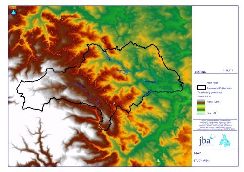
RIVER DEARNESough Dike 1:126,172RIVER DONRIVER DOVEMain RiverKnoll Beck<strong>Barnsley</strong> MBC BoundaryTopoghraphy (NextMap)Elevation (m)High : 1080.1Low : -92 ! "# !$"% ""& '!(! ) % # !*+ *% # !* !" "*+,,,-./010,,.2
RIVER DEARNESough Dike 1:126,172RIVER DOVE<strong>Barnsley</strong> MBC BoundaryRIVER DONKnoll BeckMain RiverHistorical Flood ExtentsJune 2007Autumn 2000January 1982March 1947 ! "" #$ %& "! "" #$"'%!! "%%! ($)"$ !! * & " $+,- " ""!"+ & " $+" $% " #% "+,.///.0123//14
RIVER DEARNESough DikeRIVER DONRIVER DOVEKnoll Beck Main River1:120,000Flood Zone 3<strong>Barnsley</strong> MBC Boundary !" #!$ !!% & ' ( $ " )*+ )$ " ) !!)*,---,./0121--/3
RIVER DEARNESough DikeRIVER DONRIVER DOVEKnoll Beck 1:120,000Main RiverFlood Zone 2<strong>Barnsley</strong> MBC Boundary ! "# !$"% ""& '!(! ) % # !*+, *% # !* !" "*+-...-/012..03
NorthRIVER DEARNESough DikeRIVER DONRIVER DOVEKnoll BeckLEGEND1:126,172<strong>Barnsley</strong> MBC BoundaryMain RiverExisting Flood DefencesFlood DefenceThis map is reproduced from Ordnance Surveymaterial with the permission of Ordnance Surveyon behalf of the Controller of Her Majesty’sStationary Office © Crown copyright. Unauthorisedreproduction infringes Crown copyright and maylead to prosecution or civil proceedings. 100019782 (2007)MAP 5EXISTING DEFENCES
RIVER DEARNESough DikeRIVER DONRIVER DOVEKnoll Beck Main River1:126,172<strong>Barnsley</strong> MBC BoundaryFunctional Floodplain (FZ3b) !" # $$"%!&' () $# $$"%!&'$(## $((#* +',%$' ##"- ) $"'./ $! !"$$#$. ) $"'.$ '( "!$"&(" $./0111023455113