The Multi-Modal Mobility Plan - City of Monterey
The Multi-Modal Mobility Plan - City of Monterey
The Multi-Modal Mobility Plan - City of Monterey

You also want an ePaper? Increase the reach of your titles
YUMPU automatically turns print PDFs into web optimized ePapers that Google loves.
montereyon the movemulti–modal mobility planfor the city <strong>of</strong> montereyAdopted by <strong>City</strong> Council on March 19, 2013Resolution No. 13-045Funded by the Caltrans Community-Based Transportation <strong>Plan</strong>ning Grant
acknowledgements<strong>Monterey</strong> on the MoveAdvisory CommitteeAlexander CappelliSusan Ragsdale CroninMike GallantBob GuidiTim MeehanMindy MeehanMatthew SundtMegan TolbertRena Weaver<strong>Plan</strong>ning CommissionLeon Garden – ChairWillard McCrone – Vice ChairRalph WidmarPaul W. DavisLuis OsorioMoses StitesDavid Stocker<strong>City</strong> CouncilChuck Della Sala – MayorLibby Downey – CouncilmemberAlan Haffa – CouncilmemberNancy Selfridge – CouncilmemberFrank Sollecito – CouncilmemberFred Meurer – <strong>City</strong> ManagerMike McCarthy – Assistant <strong>City</strong> ManagerParks and Recreation CommissionDennis McCarthy – ChairLouis Perske - Vice ChairMike MarottaVance BaldwinDavid CanepaSuzanne Menendez–HerbstEllen Mc EwenAl Macks – Ex Officio<strong>City</strong> <strong>of</strong> <strong>Monterey</strong> StaffAriana Green – Associate Transportation <strong>Plan</strong>nerElizabeth Caraker – Principal <strong>Plan</strong>nerRich Deal – <strong>City</strong> Traffic EngineerAndrea Renny – Associate Civil EngineerVince Pizzo – Engineering InternKevin Anderson – Environmental Regulation AnalystAnne McGrath – Communications and Outreach ManagerLaurie Huelga – Communications AssistantEric Palmer – Media AssistantMI3 CommitteeOther AcknowledgementsTransportation Agency for <strong>Monterey</strong> County (TAMC)TAMC Bike and Pedestrian Committee<strong>Monterey</strong>–Salinas Transit (MST)Presidio <strong>of</strong> <strong>Monterey</strong>Association <strong>of</strong> <strong>Monterey</strong> Bay Area Governments (AMBAG)Walter Colton Middle School<strong>City</strong> <strong>of</strong> <strong>Monterey</strong> NIP Committee<strong>Monterey</strong> Bay AquariumOld <strong>Monterey</strong> Business AssociationNew <strong>Monterey</strong> Business AssociationNew <strong>Monterey</strong> Neighborhood AssociationScholze Park Community CenterCasanova Oak Knoll Neighborhood AssociationCasanova Oak Knoll Community Center<strong>Monterey</strong> Vista Neighborhood AssociationGreen Pedal CouriersEcology Action
contentsIntroduction<strong>Plan</strong> Organization 9<strong>Plan</strong>ning Process 9Demographics 11Land Use 15Long Range <strong>Plan</strong>ning 17Objectives & ProgramsIntroduction 23Health, Safety, Education & Enforcement 23Connectivity & Access 25Encouragement & Convenience 26Wayfinding & Visitor Serving & Supportive Amenities 27Design Construction & Maintenance 28Funding & Implementation 29BicyclesIntroduction 33Benifits to Bicycling 34Bicycle Toolbox 35Existing CondItions 41Needs Analysis 49Proposed Bicycle Programs and Projects 49PedestriansIntroduction 69Existing Conditions 70Needs Analysis 74Safe Route to SchoolIntroduction 81Existing Conditions & Needs Analysis 81Active Schools 82Walk/Bike to School Program 83<strong>Multi</strong>modal Level <strong>of</strong> Service 87Funding & Implementation 95Appendix A - Master Projects List 99Appendix B - Bicycle Transportation <strong>Plan</strong> Checklist 103Appendix C - Federal Highway Administration Grants 107monterey on the move 4 adopted march 19, 2013
01introduction
introductionThis page left intentionally blank.monterey on the move 6 adopted march 19, 2013
01<strong>The</strong> <strong>City</strong> <strong>of</strong> <strong>Monterey</strong> (hereinafter, “<strong>City</strong>”) is committedto supporting and promoting alternative modes <strong>of</strong>transportation such as bicycling, walking and transit.In 2009 the <strong>City</strong> Council adopted a Bicycle Transportation<strong>Plan</strong> which, due to budget constraints, did notaddress pedestrian facilities and circulation and end<strong>of</strong> use bicycle facilities. In recognition <strong>of</strong> the need toenhance mobility options for residents and visitors,the 2009 Bicycle Transportation <strong>Plan</strong> has been expandedto address all bicycle, pedestrian and transitrider needs. In February 2012, the <strong>City</strong> receiveda Community–Based Transportation <strong>Plan</strong>ning grantfrom Caltrans to develop a <strong>Multi</strong>–<strong>Modal</strong> <strong>Mobility</strong> <strong>Plan</strong>.<strong>The</strong> result <strong>of</strong> this effort is “<strong>Monterey</strong> on the Move”.Generally, the <strong>City</strong>’s major arterials are saturated andcannot be easily expanded to improve vehicle level<strong>of</strong> service (LOS). <strong>The</strong>refore, to address impacts <strong>of</strong>future growth, the General <strong>Plan</strong> Circulation Elementgoals focus the expansion and improvements <strong>of</strong> the<strong>City</strong>’s circulation system on increasing accessibilityby bicycles, pedestrians, and transit. <strong>The</strong> CirculationElement provides thresholds <strong>of</strong> significance to measureimpacts to the <strong>City</strong>’s circulation system using a<strong>Multi</strong>–<strong>Modal</strong> Level <strong>of</strong> Service (MMLOS) that is determinedby specific criteria or “measures <strong>of</strong> effectiveness”.This plan:• Defines target MMLOS for certain areas <strong>of</strong> the<strong>City</strong>;• Identifies projects that, once implemented,will achieve the target;introduction• Defines the measures <strong>of</strong> effectiveness used todetermine whether the target is met; and,• Defines the monitoring that is required to measurethe overall progress <strong>of</strong> the multi–modalmobility plan towards achieving the General<strong>Plan</strong> goals.<strong>The</strong> General <strong>Plan</strong> Circulation Element Vision is that<strong>Monterey</strong> will be a <strong>City</strong> where alternative forms <strong>of</strong>transportation are so attractive that the use <strong>of</strong> an automobileis a choice, not a necessity. <strong>The</strong> transportationsystem will be safe for all users, and support the localeconomy while maintaining the historic character <strong>of</strong>the <strong>City</strong>. Circulation Element goals, policies and programsare intended to reduce the overall duration andfrequency <strong>of</strong> traffic congestion and parking shortageswithout relying on expansive infrastructure projects. Thisrequires a multi–modal transportation system thatprovides an excellent level <strong>of</strong> service, defined as onethat is easily available, efficient, and well coordinated.monterey on the move 7 adopted march 19, 2013
introductionCirculation Element policies require that the <strong>City</strong> adopta Travel Demand Management program to reduce thenumber <strong>of</strong> auto trips made during peak travel times;and, direct visitors to attractive transportation alternativesas they park at satellite sites served by the localtransit system.<strong>The</strong>se policies also require the development <strong>of</strong> a multi–modal mobility plan that identifies a pedestrian, bicycle,and local transit system that provides connectivity betweenneighborhoods and major destinations, such asparks, public facilities, schools, commercial service andemployment centers, residential neighborhoods, andparking structures.On September 30, 2008 Governor Arnold Schwarzeneggersigned Assembly Bill 1358, the CaliforniaComplete Streets Act. <strong>The</strong> Act states: “In order to fulfillthe commitment to reduce greenhouse gas emissions,make the most efficient use <strong>of</strong> urban land andtransportation infrastructure, and improve publichealth by encouraging physical activity, transportationplanners must find innovative ways to reduce vehiclemiles traveled (VMT) and to shift from short tripsin the automobile to biking, walking and use <strong>of</strong> publictransit. <strong>The</strong>refore, the <strong>Monterey</strong> General <strong>Plan</strong> alreadymeets these requirements and <strong>Monterey</strong> on the Movefurthers the <strong>City</strong>’s identifycation and implementation<strong>of</strong> complete streets that equally serve automobiles, bicycles,pedestrians, and transit.<strong>The</strong> <strong>City</strong> must update the multi–modal mobility planevery five years to ensure that it continues to establishdefined benchmarks or objectives; monitor andmeasure policy impacts and results; and, develop responsestrategies should the <strong>City</strong> begin moving in adirection away from the Vision Statement.Once established, these indicators must tell us whena circulation system is in place that provides safe, efficient,convenient, and inviting connections betweenmost origins and destinations that are designed forpedestrians, bicyclists, and transit riders. This systemmust be effective to a level that causes people’sdecision to drive their car to be a choice and not anecessity. Such measures <strong>of</strong> effectiveness were usedto identify and develop projects outlined in this multi–modal mobility plan.<strong>The</strong> project area includes the <strong>City</strong> <strong>of</strong> <strong>Monterey</strong>. <strong>Monterey</strong>on the Move maximizes linkages between surroundingregional facilities, the <strong>City</strong>’s mixed–use areas,visitor destinations, recreation and open spaceareas, educational facilities, and residential neighborhoods.<strong>The</strong> plan will create a comprehensive,citywide plan that will further the goals to maintain,manage, and enhance the movement <strong>of</strong> goods andpeople; and to spur the economic development andgrowth, job creation, and trade. <strong>The</strong> main plan objectivesare to:• Improve pedestrian circulation <strong>City</strong>wide byproviding safe convenient connections betweenresidential, commercial and recreationalareas;• Update the 2009 <strong>City</strong> <strong>of</strong> <strong>Monterey</strong> BicycleTransportation <strong>Plan</strong> and identify ways tomonterey on the move 8 adopted march 19, 2013
introductionstrengthen the connection between bicycling,walking and transit;• Ensure that the plan serves the diverse needs<strong>of</strong> the community while contributing to economicgrowth;• Ensure that the plan supports local, regionaland State goals to reduce greenhouse gasemissions; and,• Engage all relevant stakeholders in the planningprocess including those who are traditionally under–represented.PLAN ORGANIZATION<strong>Monterey</strong> on the Move is organized as follows:IntroductionDescribes the planning process and contains backgroundand demographic information specific to <strong>Monterey</strong>.Objectives and ProgramsThis chapter lists the plan objectives; and programsthat will work to measure or achieve those objectives.Objectives and programs are further supported in laterchapters.BicyclesThis chapter provides an analysis <strong>of</strong> existing infrastructureand bicyclists needs, and identifies projectsthat support plan objectives.PedestriansThis chapter provides an analysis <strong>of</strong> existing infrastructureand pedestrian needs and identifies projectsthat support plan objectives.Safe Routes To SchoolThis chapter identifies bicycle and pedestrian infrastructureimprovements that surround schools andoutlines programs that will educate and encouragestudents to walk and ride safely and frequently.<strong>Multi</strong>modal Level <strong>of</strong> ServiceThis chapter defines MMLOS targets for certain areas<strong>of</strong> the city; and the measures <strong>of</strong> effectiveness used toachieving plan objectives and programs as <strong>Monterey</strong>on the Move is implemented.Funding & ImplementationThis chapter identifies potential sources <strong>of</strong> funding forplan programs and projects.PLANNING PROCESS<strong>The</strong> planning process executed a scope <strong>of</strong> work thatincluded research, outreach, data collection, and objectives,projects, and program identification. <strong>The</strong> followingsummarizes the planning process:Formed Advisory Committee<strong>The</strong> first step <strong>of</strong> the <strong>Monterey</strong> on the Move planningprocess was to form an Advisory Committee <strong>of</strong> keystakeholders who identified and further defined theproject objectives, scope <strong>of</strong> work and schedule. <strong>The</strong>group was composed <strong>of</strong> representatives from:monterey on the move 9 adopted march 19, 2013
introduction• Transit and transportation agencies• Local bicycle and pedestrian advocacy groups• <strong>The</strong> Blind & Visually Impaired Center <strong>of</strong> <strong>Monterey</strong>• Presidio <strong>of</strong> <strong>Monterey</strong>• Bicycle commuters• <strong>City</strong> <strong>of</strong> <strong>Monterey</strong> <strong>Plan</strong>ning staff<strong>The</strong> Advisory Committee had several meetings to discussthe content and direction <strong>of</strong> the plan, develop apublic outreach strategy, and develop and execute afield work strategy.Existing Policy Review<strong>The</strong> Advisory Committee and <strong>City</strong> staff reviewed existinglocal and regional policies to ensure consistencywith <strong>Monterey</strong> on the Move.Public OutreachA multi–media public outreach strategy was developedto reach and receive input from a broad segment <strong>of</strong>the community. Staff attended and organized severalneighborhood meetings and community events, suchas farmers market and Bike to Work Week, to discusswhich pedestrian, bicycle and transit improvementsare most needed in the <strong>City</strong>. Input was also receivedthrough a community survey, which was distributedboth online, and in hard copy form.Once the draft plan was released for public review,members <strong>of</strong> the community had an opportunity toshare their ideas and comment on the draft duringpublic meetings <strong>of</strong> the Parks and Recreation Commission,<strong>Plan</strong>ning Commission, <strong>City</strong> Council and TransportationAgency <strong>of</strong> <strong>Monterey</strong> County (TAMC) Bicycleand Pedestrian Committee. <strong>The</strong> availability <strong>of</strong> theplan and the public meeting schedule were advertisedonline, through a public service announcement video,and in local newspapers and flyers.Data Collection<strong>The</strong> Advisory Committee assisted staff in surveyingexisting bicycle and pedestrian facilities throughoutthe <strong>City</strong> and conducting informal field interviews toidentify user needs and infrastructure in need <strong>of</strong> improvement.Transportation Engineering staff countedbicyclists and pedestrians at various locations toidentify popular routes, track user volumes, establishbaseline pedestrian counts, and observe behavior.Draft <strong>Plan</strong> DevelopmentStaff developed Objectives and Programs, Bicycle,Pedestrian, Safe Routes To School, <strong>Multi</strong>modal Level<strong>of</strong> Service, and Funding and Implementation chapters.<strong>The</strong> Advisory Committee reviewed and commentedon the initial draft plan.Environmental ReviewStaff prepared an environmental analysis to addressall potential environmental impacts that could resultfrom the implementation <strong>of</strong> the plan and prepared therequired environmental documentation according tothe California Environmental Quality Act.monterey on the move 10 adopted march 19, 2013
introductionPresentations to Decisionmakers<strong>The</strong> draft plan was reviewed, discussed, recommended,and/or adopted by the following advisory bodies:• <strong>City</strong> Council/<strong>Plan</strong>ning Commission Study Session(January 2013)• Parks and Recreation Commission (February2013)• <strong>Plan</strong>ning Commission (February 2013)• <strong>City</strong> Council (March 2013)• TAMC Bicycle and Pedestrian Committee(March 2013)DEMOGRAPHICS<strong>The</strong> transportation needs <strong>of</strong> a population are directlyrelated to the local general, physical and economicdemographics. Mode choice is affected by variousdifferent factors such as age, physical ability, urbanform and economic status. For example, some individualswithin the community cannot drive a car becausethey are either too young and do not have theirdriver’s license, are visually impaired or have otherphysical or mental challenges, or cannot afford one.This group <strong>of</strong> non–drivers includes youth, college students,physically and mentally disabled, seniors andlow–income individuals. In order to serve the trans-TABLE 1: CITY OF MONTEREY – AGE & GENDERGender (2010)AgeMale Female Total 2010 Total 2000 Percent ChangeUnder 10 years 1,346 1,239 2,585 2,898 –11%10 to 14 years 500 509 1,009 1,263 –20%15 to 19 years 948 724 1,672 1,961 –15%20 to 24 years 1,629 1,212 2,841 2,695 5%25 to 34 years 2,656 2,367 5,023 5,382 –7%35 to 44 years 1,793 1,658 3,451 4,638 –26%45 to 54 years 1,717 1,740 3,457 4,031 –14%55 to 64 years 1,634 1,841 3,475 2,396 45%65 to 74 years 920 1072 1,992 1,974 1%75 to 84 years 566 804 1,370 1,699 –19%85 years and over 281 654 935 737 27%Total 13,990 13,820 27,810 29,674 –6%U.S. Census Table DP–1–Geography–<strong>Monterey</strong> city, California: Pr<strong>of</strong>i le <strong>of</strong> General Population and HousingCharacteristics: 2010; Table DP–1. Pr<strong>of</strong>i le <strong>of</strong> General Demographic Characteristics: 2000monterey on the move 11 adopted march 19, 2013
introductionportation needs <strong>of</strong> all users, it is imperative that alternativesto the car such as walking, bicycling andtransit be widely available and easy to access.An analysis <strong>of</strong> U.S. Census data uncovered demographictrends in <strong>Monterey</strong>, which informed the development<strong>of</strong> citywide transportation objectives andpolicies incorporated in this plan.<strong>Monterey</strong> has a slowly shrinking population that isheavily influenced by the presence <strong>of</strong> the U.S. Navy,U.S. Army, and local colleges and universities. From2000 to 2010 the overall population <strong>of</strong> <strong>Monterey</strong> decreasedfrom 29,674 people to 27,810 (Table 1). However,the number <strong>of</strong> residents ages 20 to 24 yearsincreased by five percent which suggests that localcollege enrollment is stable. College students are lesslikely to own their own car and more likely than workingadults to utilize transit and active forms <strong>of</strong> transportationsuch as bicycling and walking. <strong>The</strong>reforeit is important that transit routes serve the needs <strong>of</strong>students. Transit can serve students by syncing serviceschedules with class schedules, providing directroutes between campus and activity centers wheremany students work, shop for essentials and/or live,and <strong>of</strong>fering schools discounted passes so that everystudent may have easy access to the bus.<strong>The</strong> national recession <strong>of</strong> 2008–2012 also impactedthe local economy and job market. From 2000 to 2010there was a seven percent reduction in employed<strong>Monterey</strong> residents (U.S. Census). A portion <strong>of</strong> thispercentage can be attributed to individuals leavingthe workforce for retirement. However, it is likely thatTABLE 2: MONTEREY COMMUTING TO WORK2000 2010 Percent ChangeEstimate Percent Estimate Percent %MODEWorkers 16 years and over 16,699 100% 15,479 100% –7%Car, truck, or van –– drove alone 10,854 65% 8,566 55% –21%Car, truck, or van –– carpooled 1,524 9% 1,257 8% –18%Public transportation (excludingtaxicab) 523 3%675 4%29%Walked 2,691 16% 2,876 19% 7%Other means (bicycle, motorcycle,taxi) 464 3%835 5%80%Worked at home 643 4% 1,270 8% 98%Mean travel time to work (minutes) 15.7 (X) 15.1 (X)U.S. Census Table DP03. Selected Economic: 2010; U.S. Census Table DP–3. Pr<strong>of</strong>ile <strong>of</strong> SelectedEconomic Characteristics: 2000monterey on the move 12 adopted march 19, 2013
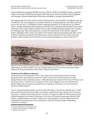
introductionFigure 1: Weekly California Retail Gasoline Prices, U.S. Energy Information Administrationlay–<strong>of</strong>fs and job scarcity are larger contributing factors.<strong>The</strong> greatest declines in population during thisperiod were seen in age groups 35 to 44 years and 10to 14 years (Table 1). Some <strong>of</strong> these individuals mayrepresent families who were victims <strong>of</strong> the economicdownturn, and had to move away in order to find workor more affordable housing.<strong>The</strong> age group 55 to 64 experienced the most substantialincrease in population from 2000 to 2010.This group represents the “Baby Boom” populationwho were born shortly after WWII. This group tendsto be more physically active than previous generationsat this age and bicycle, walk and jog for exerciseand recreation. However, Baby Boomers arealso more likely to drive a car as their primary mode<strong>of</strong> transportation for most trips. As this populationretires and ages, there will be an increased demandfor recreational bicycle and pedestrian facilities andtransit and paratransit services that are attractive toindividuals who are accustomed to convenient, directand comfortable transportation.<strong>The</strong> percentage <strong>of</strong> <strong>Monterey</strong> residents who walked,rode the bus or travelled by bicycle, motorcycle or taxito get to work increased from 2000 to 2010 (Table 2).Conversely, fewer individuals travelled to work by car,truck, van or carpool. This trend may be a result <strong>of</strong> thesteady rise in gas prices over the past decade. Since2000, gas prices have risen from $1.70 per gallon toover $4.00 per gallon in California (See Figure 1). Asgasoline–intensive transportation modes increased incost, more individuals switched to less expensive alternativemodes for more <strong>of</strong> their trips or worked fromhome. Gasoline is a finite resource and the trend <strong>of</strong> increasingcost is projected to continue on into the fore-monterey on the move 13 adopted march 19, 2013
introductionseeable future. This means the demand for alternativemodes <strong>of</strong> transportation such as transit, bicycling andwalking will necessarily increase.Advances in communication technology over the pastdecade have enabled many pr<strong>of</strong>essionals to workfrom home, and working from home has become acommonly accepted practice. <strong>The</strong> percentage <strong>of</strong><strong>Monterey</strong> workers who worked at home doubled from2000 to 2010. In order to compete with Silicon Valleyand major metropolitan areas for talent the <strong>City</strong> shouldconsider policy to allow employees the option to workfrom home when appropriate to reduce vehicle milestravelled and resulting greenhouse gas emissions.DisabledWhen planning a transportation network it is importantto consider the needs <strong>of</strong> all residents and visitorsespecially those who may have special needs such•as those with physical or cognitive disabilities. <strong>The</strong>American Disabilities Act (ADA) sets forth infrastructurerequirements to accommodate those with disabilitiesand the <strong>City</strong> has made it a priority to improve ADAaccess throughout the city. In 2011, the <strong>City</strong> began anin–depth analysis and cataloguing <strong>of</strong> ADA access atall intersections in <strong>Monterey</strong>. <strong>The</strong> final product will bea report <strong>of</strong> existing conditions and Geographic InformationSystems inventory <strong>of</strong> intersections that requirethe addition <strong>of</strong> ADA ramps.<strong>The</strong> majority <strong>of</strong> those who have physical and cognitivedisabilities in <strong>Monterey</strong> are seniors (Table 3). Mostwere not born with their disability and had to adaptlater in life. So too will the transportation networkneed to adapt to the increased demand for ADA ac-AGETABLE 3: CITY OF MONTEREY DISABILITIES BY AGE (2010)DISABILITY CHARACTERISTICHearing Vision Cognitive Ambulatory Self–Care Independent livingUnder 5 years 0 0 NA NA NA NA5 to 17 years 0 59 135 40 51 NA18 to 64 years 191 162 466 584 134 41565 years andover 541 219 338 789 390 652TOTAL 732 440 939 1413 575 1067U.S. Census Table S1810: Disability Characteristics. 2008–2010 American Community Survey 3–Year Estimatesmonterey on the move 14 adopted march 19, 2013
introductioncess, maintenance <strong>of</strong> pedestrian facilities and transit/paratransit service.<strong>The</strong> Blind and Visually Impaired Center <strong>of</strong> <strong>Monterey</strong>County is a valued resource in the community and<strong>of</strong>fers orientation and mobility training and support.In addition to teaching those with low or no vision toadapt to the existing environment, pedestrian infrastructurecan be enhanced or redesigned to make itsafer or easier to navigate. For example audible countdowndevices at signalized intersections let those whocannot see the pedestrian display how much timethey have left to cross. Improvements such as thisinstill confidence in those who are blind and visuallyimpaired and enable mobility and ultimately personalindependence.Low–Income HouseholdsLow–income households are less likely to have accessto a personal vehicle and more likely to spend ahigh percentage <strong>of</strong> their household income on gasolineif they do own a car. In 2010, those who lived inlow–income households were more likely to carpool,walk and work from home than moderate and high–incomehouseholds. A higher percentage <strong>of</strong> those wholived in moderate–income households rode publictransportation and bicycles than other income groups(Table 4).LAND USETransportation and land use are intrinsically connected.<strong>The</strong> goal <strong>of</strong> transportation is to serve landTABLE 4: COMMUTE MODE CHOICE BY ECONOMIC STATUSEconomic StatusModeBelow100% <strong>of</strong>100%to 149%At or abovePovertyLevel% OfGroup<strong>of</strong> PovertyLevel% OfGroup150% <strong>of</strong> PovertyLevel% OfGroupCar, truck, or van – drove alone 294 44% 400 58% 7,795 68%Car, truck, or van – carpooled 72 11% 52 8% 1,083 9%Public transportation (excludingtaxicab): 32 5% 48 7% 284 2%Walked 119 18% 75 11% 807 7%Taxicab, motorcycle, bicycle, orother means 21 3% 62 9% 697 6%Worked at home 123 19% 56 8% 791 7%TOTAL 661 (X) 693 (X) 11,457 (X)U.S. Census Table B08122: Means <strong>of</strong> Transportation to work by Poverty Status in the Past 12 Months.2006–2010 American Community Survey 5–Year Estimatesmonterey on the move 15 adopted march 19, 2013
introductionuses, and land uses can be organized to maximizemobility and overall efficiency <strong>of</strong> a transportation network.Historically, the available and dominate mode<strong>of</strong> transportation greatly influenced urban form. <strong>The</strong>older portions <strong>of</strong> <strong>Monterey</strong> near downtown and thewaterfront were developed when most people walkedfor daily transportation. This resulted in a compact“grid” network <strong>of</strong> narrow streets and residences locatedwithin ½ to 1 mile <strong>of</strong> shops, entertainment andemployment.<strong>The</strong> transportation network is heavily influenced bytravel behavior, user preferences and land use. Certainland use patterns such as those that allow mixed–use development and transit–oriented developmentgenerate high volumes <strong>of</strong> pedestrian and bicycle activity.Low–density residential and commercial landuses are spaced further apart and are more dependentupon motorized transportation.Most trips either originate or end at the home, whichmeans the organization <strong>of</strong> residential land uses in relationto other trip generators is vital to creating an efficienttransportation network. In order to reduce trafficcongestion, improve air quality and enable multimodaltransportation, residential areas should be locatedwithin walking distance (¼ to ½ mile) <strong>of</strong> job centers,academic institutions, shopping, parks, entertainmentand transit.Most land uses identified in the <strong>City</strong>‘s General <strong>Plan</strong>are organized to maximize mobility. However, existinglow density, single land–use development such asthose along Ragsdale Drive, Ryan Ranch Road and inthe Skyline Forest neighborhood present a challengeto providing multimodal transportation.<strong>The</strong>se areas are further than 1/2 mile to major activitycenters in <strong>Monterey</strong> and rely heavily on motorizedtransportation. Although they are outside <strong>of</strong> the comfortablewalking distance for most people, they arewithin an acceptable bicycling range <strong>of</strong> two to threemiles from major trip generators and transit. Futureplans to allow for mixed–use development will encouragemore pedestrian and bicycle activity within thearea. Private transit or carpool programs provided byemployers could also reduce single–occupant vehicletrips to and from these areas.<strong>The</strong> land uses identified in the General <strong>Plan</strong> are shownin Figure 2 and are described as follows:ResidentialVery Low Density ResidentialSingle–family residences may be developed at anaverage density <strong>of</strong> fewer than two dwelling units peracre. This type <strong>of</strong> development is solely residentialand focuses on highlighting and preserving natural resources.<strong>The</strong> topography <strong>of</strong> the area under this designationas well as the desire to maintain privacy has resultedin narrow winding roads with little connectivity.Low Density ResidentialSingle–family residences may be developed at an averagedensity <strong>of</strong> two to eight dwellings per acre.monterey on the move 16 adopted march 19, 2013
introductionMedium Density ResidentialSingle–family residences, duplexes, condominiumsand apartments may be developed at an average density<strong>of</strong> eight to thirty dwelling units per acre.Public/Semi–PublicThis category applies to all publicly owned facilitiesand those private facilities operated to serve the generalpublic except for parks and recreation facilities,which are a separate category. Included in this categoryare: public and private schools, military facilities,airports, cemeteries, large public parking facilitieshospitals, museums, conference centers and publicly–ownedhistoric buildings.Parks, Recreation and Open Space – This categoryapplies to all parks and recreation facilities such asneighborhood, community and county parks, communitycenters, greenbelts and other open space areas.IndustrialThis category applies to existing and future industrialareas in the city. <strong>The</strong>re are four areas in this categoryin the Land Use <strong>Plan</strong>. In most cases, industrial areasare taking the form <strong>of</strong> business parks with a combination<strong>of</strong> <strong>of</strong>fice and industrial uses.CommercialThis category applies to all types <strong>of</strong> commercial areasand allows the full range <strong>of</strong> commercial uses includingretail, <strong>of</strong>fice, visitor commercial and pr<strong>of</strong>essional <strong>of</strong>fices.Commercial areas are also a primary resourcefor new housing in mixed use or apartment developments.LONG RANGE PLANNINGLong range development is greatly influenced by the<strong>City</strong>’s planning documents, which include the General<strong>Plan</strong>, Area <strong>Plan</strong>s, Specific <strong>Plan</strong>s and Master <strong>Plan</strong>s.<strong>The</strong> General <strong>Plan</strong> goals set the overall tone for landuse and transportation in the <strong>City</strong>. All other implementationtools must serve to further the General <strong>Plan</strong>goals.Each planning document contains a transportationcomponent that determines how land uses withineach planning area will be served. <strong>Monterey</strong> on theMove was developed to tie together the <strong>City</strong>’s landuse documents to create a citywide, comprehensivemulti–modal transportation system that serves as animplementation tool for the <strong>City</strong>’s overall transportationgoals, policies, and objectives.<strong>The</strong> purpose <strong>of</strong> <strong>Monterey</strong> on the Move is to implementthe General <strong>Plan</strong> Circulation Element.<strong>The</strong> primary role <strong>of</strong> the Circulation Element is to providepolicy guidance for planning and implementingthe transportation system needed to serve proposeddevelopment as defined in the Land Use element <strong>of</strong>the General <strong>Plan</strong>. <strong>The</strong> transportation system affectsthe growth patterns, environment, and quality <strong>of</strong> life <strong>of</strong><strong>Monterey</strong>’s residents and workers. Much <strong>of</strong> <strong>Monterey</strong>’scharm for both residents and visitors springs from itshistoric buildings, irregular street pattern, old plazas,and waterfront views. Through the 2005 General <strong>Plan</strong>update process, <strong>Monterey</strong> citizens recognized that tryingto solve traffic problems by simply widening roadsmonterey on the move 17 adopted march 19, 2013
introductionwill negatively impact the quality <strong>of</strong> life that residentsenjoy. Building expensive parking improvements toserve peak seasonal demand will lead to facilities beingunderutilized most <strong>of</strong> the year when demand isnot at peak. <strong>The</strong> Circulation Element’s policies andprograms are intended to reduce the overall durationand frequency <strong>of</strong> traffic congestion and parking shortageswithout relying on expansive infrastructure projects.Instead, the focus is on developing alternative modes<strong>of</strong> transportation to reduce auto use but also identifyinglong term roadway solutions along the principalarterial streets. Specifically, <strong>Monterey</strong> on the Movestrives to implement the following Circulation ElementGoals:Goal a. Improve transportation and parking systemsby managing them more effectively before investingin costly roadway and parking expansion projects.Goal c. Provide a safe, efficient, well–maintained,and environmentally sound roadway system thatsupports the “complete streets” concept <strong>of</strong> equality<strong>of</strong> choice among all modes <strong>of</strong> transportation.Goal d. Promote a pedestrian/bicycle–friendly environmentwhere public spaces, streets, and <strong>of</strong>f–streetpaths <strong>of</strong>fer a level <strong>of</strong> convenience, safety, and attractivenessthat encourage and reward the use <strong>of</strong> alternativemodes <strong>of</strong> transportation.Goal f. Provide an attractive and convenient transitservice for <strong>Monterey</strong> citizens, especially those in thecommunity who cannot or choose not to own a privateautomobile.Goal j. Measure the effectiveness <strong>of</strong> the transportationsystem and its ability to safely and effectivelymove people and goods, not simply vehicles.In order to provide accessible, convenient, and efficienttransportation options throughout the <strong>City</strong>, popularorigins and destinations must be identified, andthen connections designed and implemented.Major origins and destinations throughout the <strong>City</strong> include:• Residential neighborhoods• <strong>Monterey</strong> Bay Aquarium• Downtown – shops, restaurants, conferencecenter, farmers markets, events, walk <strong>of</strong> history• Schools• Universities – Naval Postgraduate School, DefenseLanguage Institute, <strong>Monterey</strong> PeninsulaCollege, <strong>Monterey</strong> Institute <strong>of</strong> InternationalStudies• Parks, community centers, trails, and openspace areas• Recreation Trail• Airport• Major employment centers – Garden Road,Ryan Ranch, Del Monte Shopping Center, <strong>City</strong>Hall• Other commercial areas – Lighthouse/CanneryRow, Del Monte Avenue, North Fremont Street.monterey on the move 18 adopted march 19, 2013
introductionmonterey on the move 19 adopted march 19, 2013
introductionThis page left intentionally blank.monterey on the move 20 adopted march 19, 2013
&02objectives programs
objectives &programsThis page left intentionally blank.monterey on the move 22 adopted march 19, 2013
02INTRODUCTIONTo best implement the General <strong>Plan</strong> goals, policies,and programs, specific objectives were developed for<strong>Monterey</strong> on the Move. <strong>The</strong>se objectives are measurableand will help gauge whether the community isachieving its goal <strong>of</strong> developing a multimodal transportationnetwork. <strong>The</strong> six major categories <strong>of</strong> objectivesare:• Health, Safety, Education & Enforcement• Connectivity & Access• Encouragement & Convenience• Wayfinding, Visitor Serving & Supportive Amenities• Construction & Maintenance• Funding & ImplementationPrograms and projects designed to meet these objectivesare listed below and supported by the needsanalyses in the following chapters. <strong>The</strong> objectives arealso used to establish a system for prioritizing projectsfor funding (Appendix A). A matrix showing the methodfor measuring the effectiveness <strong>of</strong> each project canbe found in the <strong>Multi</strong>modal Level <strong>of</strong> Service chapter.objectives &programsProgram 1.1 – Analyze collision data biannually, documentpatterns and prioritize projects to address safetyissues.Program 1.2 – Study all marked uncontrolled midblockcrosswalks and develop warrants to install or removemidblock crosswalks. Use the California Vehicle Codepublic notification procedure for removing crosswalks.Objective 2: Create safe environments for youthwalking and bicycling to school.Program 2.1 – Support a volunteer crossing guardprogram to assist students walking to school.Program 2.2– Work with Parent Teacher Associations,school administrations and local organizations toestablish a volunteer network <strong>of</strong> walk/bike to schoolchaperones.HEALTH, SAFETY, EDUCATION ANDENFORCEMENTObjective 1: Reduce the number <strong>of</strong> collisions involvingpedestrians and bicyclists each year.monterey on the move 23 adopted march 19, 2013
objectives &programsProgram 2.3– Establish permanent drop–<strong>of</strong>f and walk locationsone-half to one mile away from schools and informparents and guardians.Program 2.4– Coordinate with <strong>Monterey</strong> High Schoolto establish a buddy program.Program 2.5– Develop Safe Routes To School walkingmaps that identify preferred walking and bicyclingroutes for all public schools within the city; updatemaps as pedestrian and bicycle infrastructure is constructedand safer routes become available.Project 2.1 – Construct a roundabout at the intersection<strong>of</strong> Soledad/Soledad/Mar Vista to calm traffic andprovide a safer and more comfortable walking route forstudents travelling to and from school.Project 2.2 – Construct an ADA accessible sidewalk onthe north side <strong>of</strong> Via Gayuba from Mar Vista Drive toWalter Colton Drive to close the gap between existingsidewalks on Walter Colton Drive and Mar Vista Drive.Project 2.3 – Construct a concrete sidewalk with verticalcurb along Soledad Drive from Via Descanso to ViaParaiso to increase the safety <strong>of</strong> these common routes.Objective 3: Ensure that all pedestrian and bicycleinfrastructure and crossings are safe and well lit.Program 3.1– Inventory the condition <strong>of</strong> existing lighting;continue to identify and prioritize necessary upgrades.Project 3.1– Sloat Ave/Fifth Street Curb Extensionscrossing treatments and lighting.Project 3.2 – Cannery Row/New <strong>Monterey</strong> RecreationTrail Crossing Safety and Lighting Improvements.Project 3.3 – Casa Verde/Recreation Trail Bicyclecrossing Improvements.Project 3.4 – Park Avenue/Recreation Trail CrossingImprovements.Project 3.5 – Figueroa/Recreation Trail Crossing Improvements,re–route recreation trail/roundabout.Project 3.6 – Audible count–down at all signalized intersections.Project 3.7 – All pedestrian phase “Pedestrian scramble”at the intersection <strong>of</strong> Alvarado and Del Monte.Objective 4: Reduce obesity rates and increaseoverall health in the <strong>City</strong> <strong>of</strong> <strong>Monterey</strong>.Program 4.1 – Partner with health providers and advocatesto lead the effort on a public awareness campaignabout obesity and the benefits to walking andbicycling in combating excessive weight gain.Program 4.2– Work with local health advocates to developa community fitness challenge program to meetor exceed the U.S. Department <strong>of</strong> Health and HumanServices minimum requirement for physical activity(60 minutes/day for youth, 20 minutes/day for adults).Encourage participants to reach their fitness goal bywalking and bicycling to school, work or lunch.monterey on the move 24 adopted march 19, 2013
Objective 5: Educate the community how to safelyand legally operate a bicycle and practice safe pedestrianbehavior.Program 5.1 – Develop and execute a multi–mediaeducation and safety campaign.Program 5.2 –Continue to provide school resources<strong>of</strong>ficers who teach laws and safety to youth.Program 5.3 – Conduct bicycle “rodeos” at schools toteach bicycle operation skills.Program 5.4 – Increase enforcement <strong>of</strong> pedestrianand bicyclist violations such as jaywalking or walkingor bicycling during the red phase at a signalized intersection;<strong>of</strong>fer bicycle/pedestrian traffic school as analternative to a monetary fine.Program 5.5 – Increase enforcement <strong>of</strong> code violationsthat have to do with blocking pedestrian and bicycleright–<strong>of</strong>–way (ex//vehicles parked in/on sidewalkor bicycle lane).Program 5.6 – Instruct waste management not toblock sidewalks or bicycle lanes with garbage and recyclingbins.CONNECTIVITY AND ACCESSObjective 6: Enhance connections between modes<strong>of</strong> transportation to reduce congestion and provideflexibility within the transportation network.Program 6.1 – Install bicycle racks on <strong>City</strong> Carpool/Vanpool vehicles.objectives &programsProgram 6.2 – Install secure/weatherpro<strong>of</strong> bicycleparking at or near transit stations and stops.Program 6.3 – Work with <strong>Monterey</strong> Salinas Transit(MST) to add larger bicycle racks to buses that do nottravel on the freeway or an additional rack to the back<strong>of</strong> the busses; also encourage the installation <strong>of</strong> bicycleracks on trolleys when the demand exists.Program 6.4 – Design and install a pedestrian and bicyclewayfinding system to and from transit.Program 6.5 – Provide on–demand access to bicycles.• Research the feasibility <strong>of</strong> a bicycle share programfocused on connections to transit andacademic institutions.• Purchase bicycles and electric bicycles for the<strong>City</strong> vehicle pool. Encourage employees touse pool bicycles for trips <strong>of</strong> 2 miles or less forfield work and inspections.Program 6.6 – Investigate the possibility <strong>of</strong> establishinga zero interest loan program to assist employeesin purchasing bicycles from local bike shops. Requirerecipients to compete a bicycle safety component eitherthrough written test or video.Program 6.7 – Continue to identify, prioritize and fundbicycle and pedestrian projects that connect majoractivity centers, employment centers, parks and openspace and residential areas.Program 6.8 – Continue to identify and prioritize andfund projects that improve bicycle and pedestrian accessand network connectivity.monterey on the move 25 adopted march 19, 2013
objectives &programsProgram 6.9 – Continue to identify locations and installbicycle parking at building entrances. Survey bicyclistsannually to determine a need and locations foradditional bicycle parking. Work with business ownersto install bicycle racks and bicycle lockers in thepublic right–<strong>of</strong>–way near businesses and inform them<strong>of</strong> other resources such as the TAMC Bicycle ProtectionProgram to purchase and install racks on privateproperty.Program 6.10 – Encourage the development <strong>of</strong> bicyclecorrals in the downtown area; develop a process forconverting an on–street parking space to a bicyclecorral.Program 6.11 – Encourage the use <strong>of</strong> bicycle valet servicesat public events.Project 6.1 – Construct bikeways and end <strong>of</strong> use facilitiesas identified in Figures 5–7 according to the prioritylisted in Appendix AObjective 7: Improve ADA access and accommodationsthroughout the city.Program 7.1 – Update the <strong>City</strong> <strong>of</strong> <strong>Monterey</strong> ADA Transition<strong>Plan</strong> to include sidewalks near transit, seniorhousing, schools and other major trip generators.Program 7.2 – Update all signalized intersections with audiblecountdown pedestrian phases.Program 7.3 – Work with PG&E to modify utility pole wiresso they are out <strong>of</strong> the path <strong>of</strong> blind and visually impairedpedestrians.Project 7.1 –Improve the Van Buren/Artillery Road connectionin two phases: install a curb ramp to provideaccess to the sidewalk on Artillery Road; replace theexisting bridge (Figure 5) with one that will expand overthe creek and above the existing stairs to provide ADAand bicycle access from Artillery Road to Van BurenStreet.Project 7.2 – Hawthorne/Bolio Bicycle/Pedestrian Connection(See Bicycles Chapter, pg 32).ENCOURAGEMENT & CONVENIENCEObjective 8: Promote active transportation andincrease mode share by improving user convenienceand through encouragement activities andprograms.Program 8.1 – Provide bicycle detection at signalizedintersections along bicycle routes.• Test existing bicycle detection annually.• Update wide intersections with video detectionor detection technology that can distinguishbetween bicyclists and other vehicles toallow for an extended green cycle.• Install bicycle detection equipment that willdetect bicycles in the left–turn lane.• When feasible, install detection that additionallycounts pedestrians and bicyclists so thatdata may be collected regularly.Program 8.2 – Encourage <strong>City</strong> employees to lead byexample and commute by alternative transportation.monterey on the move 26 adopted march 19, 2013
• Develop an incentive–based alternative commuteprogram that encourages <strong>City</strong> employeesto commute to work by walking, bicycling,transit, carpool or hybrid vehicle.• Provide discounted transit passes to employees.• Provide priority carpool/vanpool parking at<strong>City</strong> Hall.• Develop a bicycle commute facility with showerat <strong>City</strong> Hall.Program 8.3 – Organize/Support Bicycle CommuteGroups. Partner with local organizations, schools andbusinesses to organize bicycle commute groups. Potentialorganizers/facilitators <strong>of</strong> these groups are <strong>City</strong>staff, PTA members, <strong>Monterey</strong> Bay Bicycle Coalition,<strong>Monterey</strong> Bay Aquarium, Velo Club <strong>of</strong> <strong>Monterey</strong>, NavalPostgraduate School, Presidio <strong>of</strong> <strong>Monterey</strong>, <strong>Monterey</strong>Institute <strong>of</strong> international Studies and <strong>Monterey</strong> PeninsulaCollege.Program 8.4 – Organize/Support <strong>City</strong>wide Active LifestyleEncouragement Events.• Temporarily close down certain streets to automobiletraffic to celebrate active transportationand fitness activities examples from othercities are CycLAvia in Los Angeles, CA andSummer Streets in New York <strong>City</strong>, NY.• Distribute health and safety equipment, suchas water bottles, reflective pant straps, bicyclelights, and wheel lights.• Hold the event at the end <strong>of</strong> the <strong>Monterey</strong> Bike/Walk to Work & School Week (April/October).objectives &programs• Incorporate the Path <strong>of</strong> History in the festivitiesby developing a scavenger hunt.Program 8.5 – Hire or work with a Safe Routes toSchool Coordinator to plan, seek funding for and executeprograms and events for all <strong>Monterey</strong> schools.WAYFINDING, VISITOR SERVING &SUPPORTIVE AMENITIESObjective 9 – Encourage tourists to walk, bicycleand ride transit to explore <strong>Monterey</strong>.Program 9.1 – Work with TAMC to update the <strong>Monterey</strong>portion <strong>of</strong> the <strong>Monterey</strong> County Bike Map.Program 9.2 – Develop a user–friendly bicycle and pedestrianguide map that highlights visitor destinations,bicycle parking and connections to transit. Distributeguide to local hotels and bicycle rental shops.Program 9.3 – Research and develop policy allowingand regulating pedicab businesses in <strong>Monterey</strong>.Program 9.4 – Develop wayfinding signage along theRecreation Trail, popular pedestrian routes and bicycleroutes that have distance and travel time information,and are consistent with Master <strong>Plan</strong>s and Specific<strong>Plan</strong>s.Program 9.5 – Install interactive kiosks with isochronemaps that show distances and travel times in locationsdowntown, Cannery Row and the Del Monte ShoppingCenter, and are consistent with Master <strong>Plan</strong>s andSpecific <strong>Plan</strong>s.monterey on the move 27 adopted march 19, 2013
objectives &programsProgram 9.6 – Provide pedestrian infrastructure nearvisitor–serving land uses to encourage visitors to walkto their destinations instead <strong>of</strong> driving.Project 9.1 – Install public toilets in the downtown/waterfrontarea and Lighthouse/Cannery Row area.Objective 10 – Create engaging and pleasurablepedestrian environments that enhance the visitorexperience.Program 10.1– Establish a public art competition toenhance pedestrian facilities near activity centers andalong the Recreation Trail. Focus on “playable” publicart that is accessible, interactive and iconic.Program 10.2 – Support businesses along Alvaradothat would like to provide pedestrian infrastructuresuch as outdoor seating.sidewalk replacement/maintenance for areas with potentialtripping hazards.Program 11.4 – Apply the following design standardsto all projects:Bicycle parking shall be permitted within the sidewalkright–<strong>of</strong>–way permitted it does not prevent or inhibit pedestrianaccess. A minimum <strong>of</strong> four feet <strong>of</strong> sidewalk shallremain to preserve ADA access.Bicycle parking shall be located as close to the frontentry <strong>of</strong> the destination as possible and be well–lit andvisible.Bicycle racks shall <strong>of</strong>fer at least two points at whichthe bicycle can be secured and preferably support atleast one wheel. Develop a comprehensive list <strong>of</strong> acceptablebicycle rack designs.DESIGN, CONSTRUCTION AND MAIN-TENANCEObjective 11: Apply design standards and maintenanceprograms for bicycle and pedestrian facilitiesto ensure safety and longevity <strong>of</strong> facilities.Program 11.1 – Add or improve on–street bicycle facilitieswhen repaving/restriping. Grind down seam betweenpavement and concrete gutters.Program 11.2 – Merge bicycle striping project list withstreet resurfacing schedule.Program 11.3 –Survey all sidewalks in the city annuallyto identify facilities in need <strong>of</strong> maintenance. PrioritizeBicycle racks shall support the wheel and provide atleast two points at which the bicycle can be securedto the rack.Indoor bicycle parking areas shall be well lit and havecontrolled and secure access.<strong>The</strong> conversion <strong>of</strong> one on–street parking space to abicycle corral should be designed hold 10 or more bicycles.All future rail plans, public transit stations and car poollocations shall incorporate bicycle parking and storageareas in their design.monterey on the move 28 adopted march 19, 2013
objectives &programsBicycle lanes shall be 6’. In restricted locations bicyclelanes may be reduced to 5’.In residential neighborhoods or near small parks,sidewalks shall be a minimum width <strong>of</strong> 5’ (4’ unobstructedfor adequate ADA access). Wider sidewalks(6’ minimum) are recommended for commercial areasthat have higher volumes <strong>of</strong> pedestrians.Objective 12 – Provide advanced warning <strong>of</strong> bicyclelane closure and provide alternative routes or accommodationfor bicycles during road work/construction.Program 12.1 – Apply standards from the Manual onUniform Traffic Control Devices.FUNDING & IMPLEMENTATIONObjective 13 – Secure funding to implement bicycle,pedestrian and safe routes to school projects.Program 13.1– Apply for grants annually to fund programsand projects identified in <strong>Monterey</strong> on theMove.Program 13.2 – Establish a funding mechanism t<strong>of</strong>und programs and projects identified in <strong>Monterey</strong> onthe Move.Program 13.3 – Work with neighborhood representativesto fund programs and projects identified in <strong>Monterey</strong>on the Move or provide grant matches throughthe Neighborhood Improvement Program.monterey on the move 29 adopted march 19, 2013
objectives &programsThis page left intentionally blank.monterey on the move 30 adopted march 19, 2013
03bicycles
icyclesThis page left intentionally blank.monterey on the move 32 adopted march 19, 2013
03INTRODUCTIONThis chapter embodies and expands upon the 2009<strong>City</strong> <strong>of</strong> <strong>Monterey</strong> Bicycle Transportation <strong>Plan</strong>. It containsan analysis <strong>of</strong> bicyclist needs, describes existingprograms and infrastructure and identifies tools,programs and projects that will improve bicycling in<strong>Monterey</strong>. As <strong>Monterey</strong> on the Move will replace the2009 Bicycle Transportation <strong>Plan</strong>, the plan satisfiesthe requirements set forth in the California Street andHighway Code Section 891.2 and is consistent withlocal, regional and state law and planning documents.Additionally, the policies and programs herein seek toachieve the 5 E’s as recognized by the Safe Routes toSchool National Partnership and League <strong>of</strong> AmericanBicyclists: Evaluation, Engineering, Education, Encouragementand Enforcement.Since their invention in the early 1800s bicycles havemade a lasting impact on human mobility, culture andexperience. Before automobiles became affordableand widely used, bicycles were one <strong>of</strong> the most popularmodes <strong>of</strong> private transportation. Testament to thisfact the initial paving <strong>of</strong> roads in many cities was donenot to benefit motorists, but instead to provide bicyclistsa smooth surface to ride.<strong>The</strong> history <strong>of</strong> bicycling in America and across theglobe demonstrates the direct relationship betweenincreased mobility and economic growth, social equityand individual freedom. Bicycles specifically havecontributed to the enhanced mobility <strong>of</strong> traditionallydisenfranchised groups such as women, children andlow–income households because they are affordable,bicyclesaccessible and safe. In the late 1800s, women suffragistsin the U.S. encouraged bicycling as means toempowerment.“Let me tell you what I think <strong>of</strong> bicycling. I think it hasdone more to emancipate women than anything elsein the world. It gives women a feeling <strong>of</strong> freedom andself–reliance. I stand and rejoice every time I see awoman ride by on a wheel... the picture <strong>of</strong> free, untrammeledwomanhood” – Susan B. Anthony, 1896Post World War II the automobile succeeded the bicycle asthe dominant private mode <strong>of</strong> transportation in the UnitedStates, and planningfor bicyclingdid not significantlyreemergeuntil the late1970s during theU.S. energy crisis.Nationally thebicycle has seena resurgence inpopularity overthe past decade,especially in majormetropolitan areas such as Portland Oregon, MinneapolisMinnesota, New York New York, and San FranciscoCalifornia. Today bicycles remain affordable, efficient, emission–freeand uniquely fun.President John F. Kennedy once famously said“nothing compares to the simple pleasure <strong>of</strong> riding abike”. A sort <strong>of</strong> hybrid between walking and drivingmonterey on the move 33 adopted march 19, 2013
icyclesbicycling is one <strong>of</strong> the safest, healthiest and most accessiblemodes <strong>of</strong> transportation. Equally suited forrecreational, shopping and commute trips, not onlycan bicycling replace driving as a primary mode <strong>of</strong>transportation for many local trips, it can enhancemulti–modal trips as well. As an alternative to walking,bicycling can reduce the time it takes to accesstransit. When bicycles are carried aboard transit it isalso possible to reduce the travel time from transit toa final destination.A bicyclist is both a driver <strong>of</strong> a vehicle and a pedestrianand must know where and when to act like oneor the other. When riding on the street the CaliforniaVehicle Code requires that bicyclists must act and betreated as a vehicle. However, when a bicyclist dismountsthey instantly become a pedestrian and areprotected as one under the law.This adaptability can be both a blessing and a curse.As a driver, a bicyclist can take advantage <strong>of</strong> the fastestpath <strong>of</strong> travel and can then access their destinationmore directly as a pedestrian than someone drivinga car who must first locate parking before walkingto their destination. However, when bicyclists do notbehave like either a vehicle or a pedestrian they puttheir safety and the safety <strong>of</strong> others at risk.and the 2009 Bicycle Transportation <strong>Plan</strong>. Increasingthe number <strong>of</strong> trips taken by bicycle would help the<strong>City</strong> reach important goals ranging from transportationdemand management to greenhouse gas emissionsreduction.BENEFITS TO BICYCLINGBicycling promotes and improves a community’shealth, environment, economy, congestion, synergyand social equity, and transportation as follows:Health – bicycling is a low–impact form <strong>of</strong> aerobic exercisethat can help reduce obesity rates.Environmental – bicycles do not produce any greenhousegas emissions when operated, and thereforedo not contribute to air pollution, water pollution orclimate change. Bicycles also do not produce noisepollution as motorized transportation does.Economy – bicyclists spend less money per trip thanmotorists, but make more frequent trips. Propertiesnear bicycle facility projects see an increase in valueafter completion. Reduced demand for automobileparking frees up valuable land for more pr<strong>of</strong>itable endeavorsthan parking.Traffic – a bicycle is a much smaller vehicle than a carIn summary, for all <strong>of</strong> the potential economic, health, or truck and takes up less space on the roadway. Replacingand environmental benefits, bicycling remains a highlycommute trips taken by car or truck with tripsvalued mode <strong>of</strong> transportation. <strong>The</strong> <strong>City</strong> has a historytaken by bicycle would significantly increase road-<strong>of</strong> supporting and encouraging bicycling through way capacity and reduce traffic congestion on localpolicies and programs such as the <strong>City</strong>’s General streets.<strong>Plan</strong>, Climate Action <strong>Plan</strong>, Area <strong>Plan</strong>s, Specific <strong>Plan</strong>smonterey on the move 34 adopted march 19, 2013
icyclesSocial Equity – Most low–income persons who cannot afforda car for personal transportation can afford a bicycle.Bicycles enhance mobility for disadvantaged groups. Bicyclesare accessible to many non–drivers and providefreedom and opportunity especially in the case <strong>of</strong> youth.Transportation Synergy – Bicycling can be a stand–alone mode <strong>of</strong> transportation or be used to enhanceanother mode such as transit.BICYCLE TOOLBOXCalifornia bicycle facilities are subject to the CaliforniaManual on Uniform Traffic Control Devices. Californiaalso maintains its own Highway Design Manual, whichincludes a chapter on bikeways. All planned facilitiesand design standards in <strong>Monterey</strong> on the Move areconsistent with these two sets <strong>of</strong> guidelines.BikewaysBikeways are on–street or <strong>of</strong>f–street rights–<strong>of</strong>–waydesignated for bicycle transportation and designed tomeet the needs <strong>of</strong> bicyclists. According to the CaliforniaHighway Design Manual, the role <strong>of</strong> a bikeway isto “improve bicycling safety and convenience”. <strong>The</strong>reare three types <strong>of</strong> bikeway facilites: class I, class II andclass III. Each type <strong>of</strong> bikeway has a place and purpose,and all types are necessary to a comprehensivebicycle network. <strong>The</strong>re are over 25 miles <strong>of</strong> existingclass I bicycle paths and class II bicycle lanes in <strong>Monterey</strong>(Table 5).Class I Bicycle PathA class I bicycle path is physically separated from motorizedtraffic either vertically, by barrier or both. Bicyclepaths are best suited along corridors with fewinterruptions from cross–traffic. <strong>The</strong>y are primarilydesigned to improve mobility and <strong>of</strong>fer recreationalopportunities, but provide limited access to on–streetfacilities, businesses and residences. Class I bicyclepaths can greatly enhance a bicycle network, however,they should be used in addition to and not in place<strong>of</strong> on–street bicycle facilities. A functional bicycle networkrequires both on–street and <strong>of</strong>f–street facilities toaccommodate users <strong>of</strong> all experience levels.Mark Thomas Drive Class II Bicycle Lanes<strong>The</strong>re are several existing class I bicycle paths in<strong>Monterey</strong>. <strong>The</strong> best–known and most used path is theRecreation Trail which hugs the <strong>Monterey</strong> Bay coastlinefor 18 miles from Pacific Grove to Castroville. <strong>The</strong>Recreation Trail meets the State designated designstandards <strong>of</strong> a class I bicycle path but operates as amonterey on the move 35 adopted march 19, 2013
icyclesmulti–use trail and is shared between bicyclists, pedestriansand skaters.Other class I paths in the city are much smaller thanthe Recreation Trail, but still provide important connectionswithin the bicycle network. <strong>The</strong> path thatruns adjacent to Munras Avenue from El Dorado toSoledad Dr provides a direct connection between twomajor activity centers (downtown and the Del MonteShopping Center). <strong>The</strong> short class I path along MarkThomas from Santa Catalina School to the Old SalinasHighway <strong>of</strong>fers a corridor that may feel safer andmore comfortable for inexperienced bicyclists due tothe physical separation from motorized traffic.Class II Bicycle LaneSome class I paths exist to <strong>of</strong>fer scenic detours away fromthe street. <strong>The</strong> path along Aguajito Rd from Allen Dr toFarragut Rd is an example <strong>of</strong> this, as well as the RecreationTrail.A class II bicycle lane is an on–street facility markedby a striped line on the pavement, symbols and lettering.<strong>The</strong> preferred width <strong>of</strong> bicycle lanes alongcollector and arterial streets is six feet, however aminimum width <strong>of</strong> five feet is acceptable if the site isconstrained. Bicycle lanes are desirable on streetswith high volumes <strong>of</strong> fast–moving traffic as separationbetween slower moving vehicles (bicycles) and motoristsis critical to preserving speedy travel for bothmodes. Bicyclists particularly benefit from bicyclelanes during peak travel times when collector and arterialstreets are congested. While travel lanes for motoristsare stopped, bicycle lanes remain unaffectedby the congestion and <strong>of</strong>ten enable bicyclists to travelmonterey on the move 36 adopted march 19, 2013
icyclesBicycle boulevards provide important connectionsbetween residential areas and popular destinations.<strong>Monterey</strong> on the Move identifies two bicycle boulevardsthat will provide safe passage for bicyclistsbetween key residential and commercial areas andthe three future growth areas identified in the General<strong>Plan</strong>: North Fremont, Downtown and Lighthouse/Foam. <strong>The</strong>se future growth areas and nearby residentialneighborhoods are divided by three majorgeopolitical barriers: the Presidio <strong>of</strong> <strong>Monterey</strong>, NavalPostgraduate School and Lake El Estero/Cemetery.Bicycle boulevard safety enhancements, such assharrows and traffic calming devices are key elementsfor transitioning a roadway to a safe and functional bicycleboulevard. Specific safety enhancements havebeen identified and will be implemented as fundingbecomes available.Table 8: Bicycle TreatmentsTreatmentColored Lane MarkingsSharrowsBicycle BoxesMileage and DestinationSignsBicycle DetectionFloating Bicycle LaneLocationMadison St and Pacific StMark Thomas Drive at Josselyn Canyon Road and Old Salinas HwyAll Class III bikewaysDel Monte Ave/Camino AguajitoFremont St/Camino AguajitoAlvarado St/Pearl StMunras/El DoradoAlong N. FremontRecreation TrailAquarium/Cannery RowSports CenterAlvarado Street/DowntownFisherman’s WharfFairgroundsAcademic InstitutionsSignalized intersections along bicycle routesCamino El Esteromonterey on the move 38 adopted march 19, 2013
icyclesBicycle Treatments<strong>The</strong> following bikeway design treatments are intendedto enhance the safety and usability <strong>of</strong> bikeways. <strong>The</strong>ywill be used in accordance with the Manual on UniformTraffic Control Devices guidelines, issued by theFederal Highway Administration, and other relevantexisting laws and regulations. Treatments that arenot currently in the Manual on Uniform Traffic ControlDevices, such as colored lane markings and bicycleroute wayfinding signs, are considered “experimental”and will require Federal Highway AdministrationExperimental Project Approval before implementing.A summary <strong>of</strong> proposed locations for bikeway designtreatments is provided in Table 8.Colored Lane MarkingsColored pavement markings at selected bikeway locationsalert motorists and bicyclists <strong>of</strong> potential conflictareas and assign the right–<strong>of</strong>–way to bicyclists. Increasingthe visibility <strong>of</strong> bikeways reduces the numberand severity <strong>of</strong> incidents between motor vehicles andbicycles. Examples <strong>of</strong> potential areas for this treatmentin <strong>Monterey</strong> include Madison Street and PacificStreet where motorists traveling north on Pacific Streethave poor visibility when turning right onto MadisonStreet; and Mark Thomas Drive at Josselyn Canyonroad and Old Highway Road where cyclists re–enterthe roadway with motorists.Wayfinding and SignsBicycle mileage markers and wayfinding signs indicatethe distance and direction to popular destinations.<strong>The</strong>se are similar to mileage markers used onroadways for cars. <strong>The</strong>y provide a resource for cycliststo estimate travel time to destinations, they alsobenefit athletic riders who use the markers for training.Key destinations such as the Aquarium, Sports Center,Alvarado Street/Downtown, Cannery Row, Fisherman’sWharf, Fairgrounds and all major educationalinstitutions should be included on wayfinding signs.<strong>Monterey</strong> has many narrow streets that do not allowfor expansion, which creates challenges to developingnew bicycle facilities. Where on–street parkingis allowed, bicyclists are presented with the potentialsafety hazard <strong>of</strong> car doors opening and obstructingthe path <strong>of</strong> the bicyclist. By state law, bicyclists arepermitted to ride with traffic away from hazardousconditions. Signs can remind motorists that bicyclistshave this right. Signs that remind motorists to sharethe road are proposed on the downward side <strong>of</strong> steepstreets listed in the proposed routes.Bicycle DetectionBicycle Detection at signalized intersections alongbicycle routes increase convenience and encouragecorrect placement <strong>of</strong> bicyclists at the intersection. Bicycledetection technologies sense bicycles in a travellane and trigger the green phase at a signalized intersection.Currently the <strong>City</strong> uses “E” loops (inductive),which are installed below the pavement and markedby a bicycle symbol and line to show optimal alignmentfor detection. Inductive loop sensors are theleast expensive to install typically, but are not easy tomonterey on the move 39 adopted march 19, 2013
icyclesmaintain or repair and may not detect bicycles thatare made mostly <strong>of</strong> carbon fiber.Bicycle BoxInductive Loop pavement markings and signageMicrowave and video sensors are other bicycle detectionoptions. Both are more expensive up–front,but are easier to access for maintenance and repairs.Most video detection can distinguish between bicyclesand other vehicles and can monitor multiplelanes.Bicycle Boxes<strong>The</strong> bicycle box provides bicyclists a protected spacein front <strong>of</strong> queued motor vehicles at traffic signals, givingthem a head start and extra visibility when the lightturns green. This treatment is particularly helpful forbicyclists trying to turn left at a busy intersection. Proposedlocations for this treatment in <strong>Monterey</strong> includethe intersections <strong>of</strong> Del Monte Avenue and CaminoAguajito, Fremont Street and Aguajito Road, AbregoStreet and El Dorado Street and along North FremontStreet.Floating Bicycle Lane in San Franciscomonterey on the move 40 adopted march 19, 2013
icyclesFloating Bicycle LaneFloating bicycle lanes are used to meet the demandfor travel during peak commute hours and that <strong>of</strong> on–street parking during <strong>of</strong>f–peak hours. Essentially bicyclistsand parked cars share the same right–<strong>of</strong>–wayjust during different times <strong>of</strong> the day. <strong>The</strong> markingscan cause some confusion for those who have neverused floating bicycle lanes, but they <strong>of</strong>fer an opportunityfor new bicycle lanes where they have been rejectedin the past due to the desire to keep on–streetparking. This treatment is identified as a project alongCamino El Estero.Bicycle Parking<strong>The</strong> location <strong>of</strong> bicycle racks largely determines howmuch they are used. Bicyclists prefer to park as closeto their destination as possible and in a highly visiblelocation to reduce the chance <strong>of</strong> theft. Observation <strong>of</strong>bicycle rack use in the downtown area has revealedthat bicycle racks that are far away from the entranceto businesses and are partially hidden by foliage orstructures are used infrequently if at all. Instead <strong>of</strong> usingthese existing racks, bicyclists lock their bicyclesto lampposts, telephone poles, benches and railingssometimes blocking or inhibiting pedestrian access.Bicycle rack design also affects use. Some bicycleracks, such as the wheel rack design provide insufficientsupport and can damage wheels. Other rackssuch as the serpentine style racks are difficult to securea bicycle to with certain types <strong>of</strong> locks and do notuse space efficiently. <strong>The</strong>re are several different types<strong>of</strong> existing bicycle racks in <strong>Monterey</strong>, some are moredesirable than others due to superior support and securityfeatures. <strong>The</strong> most desirable bicycle designsare those that <strong>of</strong>fer multiple points to lock to, wheelsupport and frame support. Peak Racks and Inverted–Uracks best meet this criteria. Serpentine racksand wheel racks are the least desirable and their useshould be limited or discontinued.<strong>The</strong> conversion <strong>of</strong> on–street parking to bicycle parkinghas been successful in Europe and the United States.This is a cost–effective way to provide equitable parkingopportunities in the downtown area while maintainingvisibility and safety for bicyclists. A formal processshould be developed to handle requests to converton–street parking spaces to bicycle corrals. Bicyclecorrals that do not involve a loss <strong>of</strong> on–street parkingmay be installed at the discretion <strong>of</strong> the <strong>City</strong> Traffic Engineer.Bicycle valet service should be available at any publicevent if resources are available. Bicycle valets providea secure area for bicyclists to park for the duration <strong>of</strong>an event. Local bicycle clubs and community groups<strong>of</strong>fer bicycle valet services for interested venues.EXISTING CONDITIONSSince the adoption <strong>of</strong> the 2009 Bicycle Transportation<strong>Plan</strong> the following projects have been completed:• Class II Bicycle lanes on Camino Aguajito from MarkThomas Drive to Del Monte Avenue• Class II Bicycle lanes on the south side <strong>of</strong> FremontStreet from Mesa Road to Aguajito Roadmonterey on the move 41 adopted march 19, 2013
icycles• Class II Bicycle lanes on Figueroa Street fromE. Franklin Street to Wharf II• Class II Bicycle lanes on Mark Thomas Drivefrom Sloat Avenue to Aguajito Road• Class II Bicycle lanes on English Avenue fromEncina Avenue to Del Monte Avenue• Class II\III Bicycle lanes on the uphill portions<strong>of</strong> Glenwood Circle• Design <strong>of</strong> Bicycle Ramp at Hawthorne Street/Private Bolio Road• Installation <strong>of</strong> bicycle racks in the downtownareaExisting Parking and Changing FacilitiesAutomobile parking consumes an enormous amount<strong>of</strong> land and is typically the limiting factor in modernurban development. In downtown <strong>Monterey</strong> alone,roughly 1.7 million square feet <strong>of</strong> developed area isdevoted to on–street and <strong>of</strong>f–street parking, consisting<strong>of</strong>:• 320 sf/parking space in surface lots• 500 sf/single–family home <strong>of</strong>f–street parking• 160 sf/on–street parking spaceBicycles are much smaller than cars, but similarly requiresecure storage space at the end <strong>of</strong> a trip or destination.For reference, an average sized on–streetparking space can accommodate eight bicycles. Despitethe small size and low–cost <strong>of</strong> bicycle parking,the availability <strong>of</strong> automobile parking far outweighsthat <strong>of</strong> available bicycle parking in the city.Throughout the cmmunity there are over 100 bicycleparking racks and lockers. Each rack or locker issuited to fit between one and ten or more bicycles dependingon the type <strong>of</strong> rack used. Bicycle rack locationsare shown on Figures 5–7 and Table 6.<strong>The</strong> majority <strong>of</strong> bicycle racks are concentrated in thedowntown and Cannery Row areas. Currently, theonly existing changing location for bicyclists that isopen to the public is located at the Coast Guard Pier.Table 5: Existing Bikeway Miles 2012Location Facility TypeDistance(mi)Aguajito Rd Class II 3Camino Aguajito Class II 0.8Canyon Del Rey Blvd Class II 3.8Casa Verde Way Class II 0.08Garden Rd Class II 2.6Mark Thomas Dr Class II 1.33Monholland Rd Class II 3.9Ragsdale Dr Class II 3.56Sloat Ave Class II 1Total Class II Lanes = 20.07 milesAguajito Rd Class I 0.25Munras Ave Class I 0.8Recreation Trail Class I 4.75Total Class I Paths = 5.8 milesmonterey on the move 42 adopted march 19, 2013
icyclesEXISTING BIKEWAYSStreet Limits ClassAguajito Rd Allan Dr to Farragut Rd I & IIAguajito Rd Farragut to Castro Rd IIAguajito Rd Mark Thomas Dr to Allen Dr IIAguajito RdMark Thomas Dr to FremontAveIICamino AguajitoFremont St to Del MonteAveIIEnglish AveEncina Ave to Del MonteAveIIFigueroa St E. Franklin to Wharf I IIFremont St Mesa Rd to Aguajito Rd IIGarden RdFairgrounds Rd to OlmsteadRdIIHarris Ct Ragsdale Dr to end IIJustin Ct Ragsdale Dr to end IILower Ragsdale Dr Ragsdale Dr to Wilson Rd IIMark Thomas Dr Aguajito Rd to Sloat Ave IIMark Thomas Dr Sloat Ave to School Rd IIMark Thomas DrSchool Rd to Old <strong>Monterey</strong>Salinas HighwayI/II<strong>Monterey</strong> RecreationPacific Grove <strong>City</strong> Limit toTrailSeaside <strong>City</strong> LimitIMunras Ave El Dorado to Soledad IPearl St Bridges IIRagsdale Dr Hwy 69 to Wilson Rd IISloat AveDel Monte Ave to MarkThomas DrIIOwens Way Harris Ct to end IIViejo Rd Caltrans Right <strong>of</strong> Way IWilson Rd Ragsdale Dr to York Rd IIMonhollan Dr Aguajito Rd to Hwy 68 II<strong>The</strong>re are additional changing locations at privatecompanies and institutions, such as the Naval PostgraduateSchool, <strong>Monterey</strong> Institute <strong>of</strong> InternationalStudies, and <strong>Monterey</strong> Peninsula College, and at publiclocations that can be accessed through membership,such as the Sports Center. Public restrooms arealso sometimes used for changing, however they lackshowers.In 2012 the <strong>City</strong> installed two Peak Rack bicycle racksin the Trader Joe’s shopping center. <strong>The</strong> Peak Rackdesign is simple, but uses space efficiently, <strong>of</strong>fersgood wheel support and a security bar that accommodatesmost if not all types <strong>of</strong> locks. Several otherpotential peak rack locations have been identified inthe downtown area (Figure 6).Existing ProgramsExisting programs are in effect that relate to health,safety, education and enforcement. <strong>The</strong> safest placefor a bicyclist to ride is on the street where they aremore visible to motorists, have further separation fromdriveway entry and exit points and do not conflict withpedestrian activity. Of course, not everyone feelscomfortable riding with motorized traffic, which is whymonterey on the move 43 adopted march 19, 2013
icyclesClass I facilities such as the Recreation Trail, are sopopular. Unfortunately when used improperly, eventhe Recreation Trail can feel unsafe, especially whencrowded with a mix <strong>of</strong> user types and speeds.Community Action TeamBecause multi–use trails such as the Recreation Trailare shared by several different modes, the <strong>City</strong> adoptedrules <strong>of</strong> conduct to mitigate user conflict. Whenthe rules are followed, the facility operates smoothly.<strong>The</strong> <strong>Monterey</strong> Police Department currently has tw<strong>of</strong>ull time <strong>of</strong>ficers assigned to the Community ActionTeam who conduct patrol by bicycle. <strong>The</strong>se <strong>of</strong>ficerspatrol the Recreation Trail and the Old <strong>Monterey</strong> BusinessDistrict day and night. <strong>The</strong>se <strong>of</strong>ficers have thesame responsibilities as <strong>of</strong>ficers inside a patrol car.In addition, the Community Action Team <strong>of</strong>ficers educatethe public on proper bicycle safety laws. <strong>The</strong>sesafety laws include riding with a helmet for youth under18 years <strong>of</strong> age and proper equipment function(such as breaks or lights). <strong>The</strong>y also educate motoristson sharing the road with bicyclists and the rules<strong>of</strong> the road.Community Action Team’s goal is to provide the communityand its visitors with a police presence in areasthat are not easily accessible by patrol car.Bicycle Rodeos<strong>The</strong> Community Action Team works closely with the<strong>Monterey</strong> Police Department School Resource Officerto educate students on bicycle safety and laws. In theSpring <strong>of</strong> 2008, <strong>Monterey</strong> Police Department and theTABLE 6: EXISTING BICYCLE RACKSBicycle RacksLocationCannery Row 2Aquarium 1Coast Guard Lot and Navy Pier 2Wave Street 2Foam Street and Drake Avenue 1Hilltop Park 1<strong>Monterey</strong> Hostel (778 Hawthorne) 3<strong>Monterey</strong> Bay Coastal Trail 20+Harbormaster’s Office 1<strong>Monterey</strong> Sports Center 3Franklin Street and Figueroa Street 1Dennis the Menace Park 3Alvarado Street 7Pacific Avenue 4Custom House/Portola Plaza 3Calle Principal Garage 3<strong>Monterey</strong> Transit Plaza 1East Village C<strong>of</strong>fee House and Plaza 3Peet’s C<strong>of</strong>fee/Trader Joe’s 5Peter B’s 1Constuction Management Office 1Colton Hall (580 Pacific Street) 2Library (625 Pacific Street) 2Human Resources (735 Pacific Street)2 (3 wallmount)Post Office 1Macy’s 2Whole Foods 3<strong>Monterey</strong> Peninsula College (MPC) 5monterey on the move 44 adopted march 19, 2013
icyclesTraffic Engineering Department held a Bicycle rode<strong>of</strong>or elementary school students. <strong>The</strong> <strong>Monterey</strong> PoliceDepartment also participated in a BMX bicycle showat Bay View Elementary School, introducing studentsto the Community Action Team <strong>of</strong>ficers and the <strong>Monterey</strong>Police Department, while reviewing safe bicyclingtechniques. Ecology Action, a local non–pr<strong>of</strong>itorganization continued this effort in Spring <strong>of</strong> 2012during Bike to School Week.NEEDS ANALYSISBicyclists have varying levels <strong>of</strong> experience and abilities,different socio–economic backgrounds, and assorteddestinations. All <strong>of</strong> these factors contribute totravel behavior and may also present barriers to bicycling.A community survey was conducted on–lineand in person at events. Survey results reveal theneeds <strong>of</strong> this diverse group, which include the followingcategories:• Commuters• Safety• Connectivity & AccessCommutersMost people in <strong>Monterey</strong> bicycle for recreation andfitness, however a growing number <strong>of</strong> residents arebicycling to work or school (Table 7). Commuter tripsare the biggest contributor to regular traffic congestionin <strong>Monterey</strong>. If more people commuted by bicycletwo or more days per week, it would equate to realhealth and environmental benefits and reduce trafficcongestion. Despite the known benefits, most peopledo not commute by bicycle (less than 5% in 2010).Some <strong>of</strong> the common perceived issues with commutingby bicycle:• Don’t have time, takes too long• Don’t want to get sweaty before work• Don’t own a bicycle• Not comfortable riding in traffic• Not comfortable riding at night after work• Poor weather – too hot or cold, humid, or raining• Carrying too much stuff• Have to drop <strong>of</strong>f/pick up childrenMany <strong>of</strong> the aforementioned barriers to commuting bybicycle can be remedied through incentive programs,organized commute group rides and access to publicshower/changing facilities. However, the underlyingissue may be that travel behavior is simply difficult tochange. It is a slow process, but communities thathave methodically incorporated bicycling into localculture through improved infrastructure, outreach andsupportive programs and events have seen an increasein overall trips by bicycle.For those who bicycle already, it is important to continueto improve and maintain facilities and grow themonterey on the move 45 adopted march 19, 2013
icyclesexisting network so that popular destinations becomemore accessible and convenient to get to. <strong>The</strong> majority<strong>of</strong> survey respondents stated that they rode a bicyclefor recreation to access parks and open space aswell as restaurants and retail stores (Figure 3). <strong>The</strong>reforeit is important to have adequate bicycle accessand parking at these types <strong>of</strong> destinations.SafetyWhen asked “where don’t you enjoy bicycling”, themost commonly named locations were streets withhigh volumes <strong>of</strong> fast–moving vehicular traffic whereriders feel uncomfortable or unsafe. Many survey respondentsalso reported that they do not enjoy ridingon the Recreation Trail when it is crowded. <strong>The</strong>y listedthe following streets as the least bicycle–friendlyin <strong>Monterey</strong>:• Del Monte Avenue• Lighthouse Avenue• Pacific Street• Fremont Street• North Fremont StreetPolice recordsconfirm that thesestreets have thehighest rate <strong>of</strong> collisionsinvolving abicyclists or pedestrian,although mostincidents occurredat or near an intersection. Additionally there were afew reported collisions at Recreation Trail crossings(Casa Verde and Cannery Row) but none actuallyalong the length <strong>of</strong> the facility.Although it is usually the bicyclist who is injured in acollision with a motorized vehicle, the driver <strong>of</strong> the motorizedvehicle is not always at fault. Pedestrians haveright <strong>of</strong> way at marked crosswalks such as the RecreationTrail Crossings provided they practice due carewhen crossing. Bicyclists who dismount and walk inthe crosswalk are also considered pedestrians underthe law. However, if bicyclists ride through the intersectionthey are considered vehicles under the lawand must yield to motorists (CA Vehicle Code Section21950).<strong>The</strong> majority <strong>of</strong> survey respondents wanted moreClass II bicycle lanes and well–marked bicycle routeson streets with less vehicular traffic (Figure 4). <strong>The</strong>setypes <strong>of</strong> bicycle projects should be given high priorityalong with Recreation Trail crossing improvements, intersectionimprovements and traffic calming projects.Connectivity & Access<strong>The</strong> major barriers to bicycle access and connectivityin <strong>Monterey</strong> are one–way streets, jurisdictional boundaries,inadequate on–street and end <strong>of</strong> use facilities,and lack <strong>of</strong> bicycle detection at signalized intersections.One–way streets force travelers, especiallyInverted–U RackPeak RackHitching Post Rackmonterey on the move 46 adopted march 19, 2013
icyclesSerpentine RackWheel Rackthose unfamiliar with the street network, to take longer,indirect routes to reach their desired destination.Long–range planning efforts have identified transportationissues and opportunities related to existingand proposed land uses across the city. <strong>The</strong> <strong>City</strong>’sspecific/master plans seek to improve mobility. <strong>Monterey</strong>on the Move serves as an implementation toolfor such improvements.New <strong>Monterey</strong> / Cannery Row<strong>The</strong> Lighthouse Avenue corridor is an important connectionfrom the New <strong>Monterey</strong> neighborhood toDowntown and other areas <strong>of</strong> the city. Due to restrictedaccess through the Presidio <strong>of</strong> <strong>Monterey</strong> which liesbetween New <strong>Monterey</strong> and the rest <strong>of</strong> the city, LighthouseAvenue is heavily impacted during peak hours.Given the high volumes <strong>of</strong> traffic, bicycle lanes wouldbe the most appropriate facility to improve safety.However, unless on–street parking along LighthouseAvenue was eliminated, the right–<strong>of</strong>–way is too constrainedto accommodate Class II bicycle lanes. If,at some point in the future, the <strong>City</strong> Council decidesto eliminate on–street parking along Lighthouse Avenueor otherwise change the circulation pattern,bicycle lanes should be installed in between PrivateBolio Road and David Avenue. <strong>The</strong>refore, to completea multi–modal corridor through New <strong>Monterey</strong>, <strong>Monterey</strong>on the Move identifies bicycle travel routes onalternative streets to connect to other destinations inthe <strong>City</strong>.<strong>The</strong> Recreation Trail is the main route for cyclists andpedestrians between Cannery Row and the Down-TABLE 7: MONTEREY COMMUTING TO WORK2000 2010 PercentEstimate Percent Estimate Percent ChangeMODE%Workers 16 years and over 16,699 100% 15,479 100% –7%Car, truck, or van –– drove alone 10,854 65% 8,566 55% –21%Car, truck, or van –– carpooled 1,524 9% 1,257 8% –18%Public transportation (excluding taxis) 523 3% 675 4% 29%Walked 2,691 16% 2,876 19% 7%Other means (bicycle, motorcycle, taxi) 464 3% 835 5% 80%Worked at home 643 4% 1,270 8% 98%Mean travel time to work (minutes) 15.7 (X) 15.1 (X)U.S. Census Table DP03. Selected Economic: 2010; U.S. Census Table DP–3. Pr<strong>of</strong>i le <strong>of</strong> Selected EconomicCharacteristics: 2000monterey on the move 47 adopted march 19, 2013
icyclestown. During the high tourist season and weekends,the Recreation Trail can be congested and occasionallyconflicts may arise between the faster movingcyclists and the meandering visitors. Recreation Trailcrossings also pose a potential conflict between thetrail users and street traffic. Commuters <strong>of</strong>ten bypassthe most congested sections <strong>of</strong> the trail and use WaveStreet as an alternative route. <strong>The</strong>refore, alternativeFigure 3: Community Survey Resultsmonterey on the move 48 adopted march 19, 2013
icyclesroutes that connect this portion <strong>of</strong> the <strong>City</strong> to destinationsare necessary to maintain the safety and enjoyment<strong>of</strong> the Recreation Trail for all user groups.Downtown and Waterfront AreasOne–way streets and the Alvarado Mall in the downtownarea limit bicycle access to and from the RecreationTrail and other desired destinations. Currently,cyclists are prohibited from riding along the AlvaradoMall. For a bicyclist to legally access Alvarado Streetfrom the Recreation Trail, they must ride along OlivierStreet, Scott Street, Pacific Street, and Franklin Streetor ride down to access Figueroa Street then PearlStreet or dismount and walk to Alvarado Street alongthe Alvarado Mall. In practice, many bicyclists havebeen observed illegally riding along the Alvarado Mallor down the sidewalk on Alvarado Street.Bicyclists are prohibited from riding on the sidewalkalong Alvarado Street for safety reasons. Bicycliststravel at higher speeds than pedestrians and thereforehave less time to react to obstacles as they appear.Additionally, pedestrians and drivers do not expect bicycliststo be riding on the sidewalk and may not lookfor them when turning out <strong>of</strong> shops or driveways. Inshort, when bicyclists ride on sidewalks they increasetheir chances <strong>of</strong> being involved in a collision with a pedestrianor motor vehicle especially in areas with highvolumes <strong>of</strong> pedestrian traffic such as Alvarado Streetand Downtown.<strong>The</strong> circulation chapter <strong>of</strong> the Downtown Specific<strong>Plan</strong> requires the conversion <strong>of</strong> the one–way streetsto two–way to improve circulation and access. Consistentwith this concept, bicycle facilities should beadded in each direction to Alvarado Street and EastFranklin Street. <strong>The</strong> Specific <strong>Plan</strong> also proposes partiallyclosing Polk and Pearl streets, allowing limitedvehicular traffic access, and creating a bicycle and pedestrianconnection between significant historic buildingsdowntown. <strong>The</strong> Specific <strong>Plan</strong> also recommendsallowing limited vehicular access through the AlvaradoMall to improve connectivity to the Recreation Trail andthe waterfront.Major opportunities for improved bicycle circulationhave also been proposed in the Waterfront Master<strong>Plan</strong>. One such improvement would be a pedestrianand bicycle promenade along the harbor. Additionalbicycle parking and bicycle sharing are also recommendedin the plan. Concepts for improving pedestrianand bicycle access between the waterfront andDowntown across the Del Monte Avenue/WashingtonStreet intersection will continue to evolve. When adopted,such concepts will be incorporated into <strong>Monterey</strong>on the Move.Bicycle parking in the downtown area does not meetcurrent needs. During busy times, such as the weeklyfarmers market and special events, as many as 40parked bicycles have been counted. At these timesbicycles are chained to trees and handrails due to lack<strong>of</strong> available bicycle parking. <strong>The</strong> average number <strong>of</strong>bicycles parked on Alvarado Street is between 20–30during farmer’s market and 10–15 at any given timeduring the week.monterey on the move 49 adopted march 19, 2013
icyclesA downtown multimodal center is envisioned in thevicinity <strong>of</strong> Franklin Street and Washington Street. Thisstation will be a major transportation hub and transfercenter. To encourage both visitors and residentsto use alternative modes <strong>of</strong> transportation to travel in<strong>Monterey</strong>, it is important that the station be easily accessibleby walking and bicycling. When the locationFigure 4: Community Survey Resultsmonterey on the move 50 adopted march 19, 2013
icycles<strong>of</strong> the multimodal station has been finalized, this planshall be revised as necessary to ensure its implementation.North Fremont / Highway 68North Fremont Street is an arterial street with a generousright–<strong>of</strong>–way width that connects <strong>Monterey</strong> andthe cities <strong>of</strong> Seaside and Del Rey Oaks. Canyon DelRey provides a class II bicycle lane that accessesGeneral Jim Moore Boulevard, South Boundary Road,and Highway 68, which provide connections to RyanRanch and other destinations within the County, Seaside,Marina, and Salinas.PROPOSED BICYCLE PROGRAMSAND PROJECTSThis section expands upon the bicycle related programsand projects identified in the Objectives Chapter.<strong>The</strong>se programs and projects for bicycle facilities,which together with the pedestrian programs and projects,and the related design standards, serve as theimplementation mechanism to achieve General <strong>Plan</strong>vision. <strong>The</strong> bicycle projects (bikeways, bicycle parkingand other end <strong>of</strong> use facilities) have been identifiedand prioritized (see Appendix A) based on the objectiveslisted in the previous chapter, and are discussedbelow by area. New bikeways will connect to the existingbicycle network and accommodate current andfuture ridership patterns, consistent with future growthpatterns described in the General <strong>Plan</strong>. Figures 5–7identify existing and proposed bikeway and bicycle facilitylocations. Table 9 provides a comprehensive list<strong>of</strong> proposed bicycle lanes.New <strong>Monterey</strong> / Cannery RowBikeways<strong>The</strong> New <strong>Monterey</strong> Bicycle Boulevard, and specificallythe connection from Private Bolio Road to HawthorneStreet, provides an alternate connection between New<strong>Monterey</strong> and Downtown that does not require crossingLighthouse Avenue to access the Recreation Trail.This connection also complements the Army’s goal <strong>of</strong>improving bicycle access to the Presidio.<strong>The</strong> New <strong>Monterey</strong> Bicycle Boulevard includes classIII lanes on Laine Street, H<strong>of</strong>fman Avenue, and HawthorneStreet. <strong>The</strong> route travels southeast on LaineStreet from David Avenue, turns left at Reeside, righton Hawthorne and then connects to the lower Presi-Hawthorne/Bolio Ramp Renderingmonterey on the move 51 adopted march 19, 2013
icyclesdio. This connection requires construction <strong>of</strong> a rampfrom Hawthorne Street to Private Bolio Road, due tosignificant elevation change. <strong>The</strong> Hawthorne/Bolio bicycleramp has been designed and will proceed withconstruction when funding becomes available.<strong>The</strong> route continues through the lower Presidio andconnects to Van Buren Street. To make this connectionbicycle–friendly, construction <strong>of</strong> a new path willbe required near the existing stairs between SeenoStreet and Artillery Street. After reaching Van BurenStreet, riders will have the option <strong>of</strong> turning left ontoeither Scott Street or Franklin Street to connect withAlvarado Street or continuing on to Madison Streetwhere it is possible to turn left to connect to the EastDowntown Bicycle Boulevard or right to travel toward<strong>Monterey</strong> High School.A contra–flow lane along Reeside Avenue betweenHawthorne and Foam Street would provide connectionacross Lighthouse Avenue to the Recreation Trail.Bicycle detection is also necessary at the intersection<strong>of</strong> Reeside Avenue and Lighthouse Avenue.Wave Street is <strong>of</strong>ten used by commuters and fastercyclists as an alternative route to the Recreation Trailduring the trail’s more congested times. A class IIIroute is proposed along Wave Street to increase thesafety <strong>of</strong> this alternative route.<strong>Monterey</strong> on the Move addresses Recreation Trailsafety and congestion a number <strong>of</strong> ways. Construction<strong>of</strong> the New <strong>Monterey</strong> bicycle boulevard and theWave Street bicycle route will provide locals, commuters,and faster cyclists an alternative route to theRecreation Trail. Once these alternative routes are inplace, the relocation <strong>of</strong> these user groups from theRecreation Trail will relieve congestion and decreaseconflicts that may arise between the faster movingcyclists and the meandering pedestrians. RecreationTrail crossing safety and lighting improvements areproposed at all intersections between Reeside Avenueand David Avenue. Also, where feasible, theRecreation Trail may be widened at locations betweenWharf 1 and the Aquarium.Bicycle Parking<strong>The</strong> Cannery Row/Aquarium area is a popular destinationfor bicyclists as it is easily accessed by the RecreationTrail. Bicycle parking in front <strong>of</strong> the Aquariumregularly overflows, especially on weekend days. Additionalracks along Cannery Row are poorly placedand <strong>of</strong>ten overlooked by residents and visitors alike.A bicycle corral is recommended for this area on CanneryRow as well as additional racks near the entranceto the Aquarium.Downtown and WaterfrontBikeways<strong>The</strong> Downtown Bicycle Boulevard will connect two keyareas <strong>of</strong> the <strong>City</strong> and provide a much needed bicyclelink through the downtown area that will increase safetyand encourage use. <strong>The</strong> Downtown Bicycle Boulevardwill extend the class III route from Van BurenStreet to Camino Aguajito, traveling east on JeffersonStreet, Pearl Street and Third Street. It will then turnmonterey on the move 52 adopted march 19, 2013
icyclessouth onto Camino Aguajito onto an existing class IIroute towards <strong>Monterey</strong> Peninsula College and continueunder Highway 1. At Mark Thomas Drive, theclass II route turns east to connect to the North FremontBikeway.One–way lanes would be developed to match existingtraffic flows (such as Polk, between Alvarado Streetand Hartnell Street). <strong>The</strong> Pearl Street and Polk Streetlimited access streets proposed in the DowntownSpecific <strong>Plan</strong> will add great value to this section <strong>of</strong>the bicycle boulevard. A bicycle box (a designatedarea for bicycles to stop, increasing their visibility anda vehicle’s visibility <strong>of</strong> cyclists) will be located at thePearl/Alvarado intersection. This will allow cyclists tomove to the center <strong>of</strong> the lanes for improved visibility.Bicycle detection will be provided at all signalized intersectionsalong the route.Areas benefiting from this bikeway include the residentialareas <strong>of</strong> Old Town, Casanova–Oak knoll, JosselynCanyon/Deer Flats, La Mesa, and Oak Grove as wellas three major educational institutions. Businessesand residents in Downtown and along North Fremontwill benefit from increased bicycle access. In addition,<strong>City</strong> <strong>of</strong>fices, businesses, such as Trader Joes,and many residential dwellings are located along ornear this route.Other proposed projects will increase safety andconnectivity between Downtown <strong>Monterey</strong> and theRecreation Trail. Two new routes include Abrego/Washington Street between El Dorado Road and theRecreation Trail (class II) and a transitional bicyclelane along Camino El Estero between Fremont Streetand the Recreation Trail. Safety improvements for DelMonte Avenue crossings are proposed at Camino ElEstero, Camino Aquajito, Sloat Avenue, and EnglishAvenue. <strong>The</strong>se improvements include bike detection,ADA ramps, audible pedestrian detection, and classI bicycle paths from Del Monte Avenue to the RecreationTrail. <strong>The</strong> English Avenue crossing also includeselimination <strong>of</strong> the eastbound free right from EnglishAvenue to Del Monte Avenue.Pacific Street provides another north/south route betweenSoledad Drive and the Waterfront and accessesresidential neighborhoods, schools, public facilities,and commercial services. Class III bicycle facilitiesare proposed between Scott Street and Grove Street.Between Grove Street and Soledad Drive, class IIsouthbound and class III northbound facilities are proposed.<strong>The</strong> Downtown Specific <strong>Plan</strong> recommends allowingbicycle access through the Alvarado Mall to accessthe Recreation Trail. Limited vehicle access may alsobe permitted at certain times, subject to future <strong>City</strong>Council consideration.Within the Waterfront area, Recreation Trail wideningis proposed between La Playa Street and Wharf II,where feasible. Safety improvements will be incorporatedwhere the Recreation Trail intersects FigueroaStreet and Park Avenue. An alternative bicycle route/pedestrian plaza is proposed between Wharf I andWharf II that follows the shoreline/harbor.monterey on the move 53 adopted march 19, 2013
icyclesA lesser–known class I bicycle path connects El Doradoand Munras Avenue with the Del Monte ShoppingCenter. Improvements to the El Dorado/Munrasintersection will increase safety and visibility for cyclistsmaking the transition between the street and thebicycle path, which include colored bicycle lanes, abicycle box, and bicycle detection.Traffic traveling westbound along Fremont Street runsadjacent to El Estero Park. A class I connection couldbe accommodated between Camino Aguajito andCamino El Estero. If space permits, a class II facilityshould be added to both sides <strong>of</strong> Fremont betweenCamino El Estero and Abrego Street.Bicycle Parking and FacilitiesFigure 5 shows proposed locations for bicycle parkingin the downtown area, including throughout thecommercial areas and within Jack’s Park, Dennis theMenace Park, and the Waterfront/Window on the Bay.Shower/changing facilities would encourage increasedbicycling/walking commutes if located withinthe vicinity <strong>of</strong> <strong>City</strong> Hall and the proposed Downtown<strong>Multi</strong>modal Station. Such enhancements to the existingCalle Principal restroom or <strong>City</strong> Hall restroomswould provide this incentive.Transit and Transit Station FacilitiesBicyclists <strong>of</strong>ten depend on combining alternativemodes <strong>of</strong> transportation to reach their destination andtherefore require that forms <strong>of</strong> transit, such as buses,light rail and commuter rail, accommodate bicycles.<strong>Monterey</strong>–Salinas Transit buses provide the primarytransit service in <strong>Monterey</strong>. Currently, the <strong>Monterey</strong>MST transit hub is located at Simoneau Plaza betweenTyler Street, Munras Avenue and Pearl Street.A multimodal station has been proposed in the vicinity<strong>of</strong> Washington Street and East Franklin Street. <strong>The</strong>station would serve bus, bus rapid transit, light rail,and bicycle transportation. AMTRAK and Greyhoundbus connections may also be possible. All future railplans, public transit stations and car pool locationsshould incorporate bicycle parking and storage areasin their design.All MST buses are equipped with bicycle racks andfolding bicycles may also be brought aboard at thedriver’s discretion. On–board bicycle carrying capacityshould be maximized on all modes <strong>of</strong> transit wherefeasible by installing larger racks on buses that do notdrive on the freeway or by adding a rack to the back <strong>of</strong>the bus. Some transit stops <strong>of</strong>fer bicycle racks (short–term parking) or bicycle lockers (longer–term parking)however additional parking facilities are needed.North Fremont / Highway 68Bikeways<strong>The</strong> North Fremont Bikeway is a Class II bikeway thatwill run along North Fremont Street from Canyon DelRey Boulevard to Casa Verde Way (Figure 7). Thisroute will <strong>of</strong>fer safe transport opportunities for commutersand tourists. At Casa Verde Way, a bicyclebox will provide cyclists with a safe option <strong>of</strong> turningsouth towards the fairgrounds and then west alongMark Thomas Drive to connect to the East Downtownmonterey on the move 54 adopted march 19, 2013
icyclesTABLE 9: PROPOSED BICYCLE LANESStreet Limit 1 Limit 2 ClassNew <strong>Monterey</strong>Laine St David Ave Reeside Ave IIIH<strong>of</strong>fman Ave Laine St Recreation Trail IIIReeside Ave Laine St Hawthorne St IIIReeside Ave Hawthorne St Foam St contra-flowHawthorne St Reeside Ave Private Bolio III/IIHawthorne St terminus Corporal Ewing ICorporal Ewing Private Bolio Artillery St IIOld Town/Downtown/East DowntownVan Buren St Artillery St Seeno St IVan Buren St Seeno St Madison St II or IIIMadison St Pacific St Hartnell St IIMadison St Pacific St Herrmann Dr II (uphill); III (downhill)Herrmann Dr Larking Via Paraiso II/IIIJefferson Ave Alvarado St Veterans Dr IIFranklin St Presidio Gate Van Buren II (uphill); III (downhill)Scott St Van Buren Oliver/Rec Trail IIIPolk St Hartnell St Alvarado St IIAlvarado St Pearl St Recreation Trail II or IIIPearl St Alvarado St Camino Aguajito IIIFigueroa St Pearl St Wharf 2 II/IIICamino El Estero Fremont St Del Monte Ave II/III/FloatingAbrego St El Dorado Pearl St IIWashington St Pearl St Recreation Trail II3rd St Camino Aguajito Sloat Ave IIIStreet Limit 1 Limit 2 ClassNorth Fremont /Hwy 68Josselyn Canyon Mark Thomas Dr Hwy 68 IIIMark Thomas Dr Sloat Ave Garden Rd IIFairground Rd Garden Rd Airport Rd IIIGarden Rd Fairground Rd Existing class II IIOlmsted Rd Garden Rd Hwy 68 IICasa Verde Ave Fairground Rd Del Monte Ave III/IINorth Fremont Canyon Del Rey Casa Verde Ave IIAirport/Euclid North Fremont Casanova Ave IIIOther AreasFremont St E/B Munras Mesa Rd IIFremont St W/B Camino Aguajito Camino El Estero IEnglish Ave Hwy 1 <strong>of</strong>framp Montecito Ave IIIMontecito Ave English Ave Casa Verde Ave IIICasanova Ave Montecito Ave Euclid IIIMunras Ave Soledad El Dorado IIEl Dorado Pacific St St Munras Ave IIPacific St Artillery Grove St IIIPacific St Grove St Soledad Dr II (uphill); III (downhill)Soledad Dr Munras Ave Pacific St IISoledad Dr Munras Ave Viejo Rd IIViejo Rd <strong>City</strong> Limit Soledad Dr IIBarnet Segal Leahy Rd Soledad Dr II/IIISkyline Forest Holman Hwy 68 Skyline Dr IIISkyline Dr Skyline Forest Chatswood Pl IIIVeterans Dr Chatswood Pl Johnson Ave IIIS. Boundary Rd York Rd Gen Jim Blvd IIYork Rd Hwy 68 S. Boundary Rd II/IIImonterey on the move 55 adopted march 19, 2013
icyclesBicycle Boulevard. Alternatively, the cyclist may turnnorth onto Casa Verde Way and travel along CasaVerde Way to connect to the Recreation Trail. A safetysolution at the Casa Verde Way and Recreation Trailcrossing is also being developed. Class III facilitiesare also proposed through the Casanova Oak Knolland Villa Del Monte neighborhoods along CasanovaAvenue, Airport Road, Casa Verde, English Avenue,and Montecito Avenue. Bicycle detection is proposedat Casanova Avenue at North Fremont Street, andFairgrounds Road at Garden Road.<strong>The</strong> North Fremont Specific <strong>Plan</strong> and <strong>Monterey</strong> on theMove place new bicycle facilities along this corridor asit is the most direct route for many bicycle commuters.Once the multi–modal improvements are complete,North Fremont will serve as a complete street, providingbus rapid transit service, class II bicycle lanes,and pedestrian friendly sidewalks. <strong>The</strong> North FremontBikeway will also implement components <strong>of</strong> the NorthFremont Streetscape plan to improve pedestrian safetyand further the vision <strong>of</strong> the North Fremont Specific<strong>Plan</strong> to be a multimodal mixed–use neighborhoodand encourage alternative modes <strong>of</strong> transit to eventsat the fairgrounds.Within former Fort Ord, Del Rey Oaks and <strong>Monterey</strong>own adjacent land along South Boundary Road. Asthis land develops, improvements to South BoundaryRoad will be constructed to include class II bicyclelanes. Proposed improvements to Garden Road willincrease access to the <strong>Monterey</strong> Municipal Airport andemployment centers along Garden Road. Proposedimprovements to Mark Thomas Drive will completea vital connection between many key destinations,including the Downtown, North Fremont, GardenRoad, the Fairgrounds, churches, hotels, and SantaCatalina School. A proposed class III facility alongJocelyn Canyon Road provides an alternative routeconnecting Mark Thomas Drive to Highway 68.Bicycle Parking and FacilitiesDue to the frequency and large scale <strong>of</strong> events thatoccur at the Fairgrounds, there is a regular demandfor bicycle parking. This demand could be metthrough the addition <strong>of</strong> new bicycle racks or by providingbicycle valet service at all events.Suggested changing/shower facility locations includewithin the Ryan Ranch Complex and alongGarden Road.Other AreasAdditional proposed bikeways provide vital connectionsthroughout the <strong>City</strong> (Figures 5–8). <strong>The</strong>se linksconnect the two bicycle boulevards and the NorthFremont Bikeway to residential neighborhoods, educationalfacilities and parks. <strong>The</strong>se routes includeGlenwood Circle class II/III, Viejo Road class II fromSoledad Drive to the existing class I bike path, improvementsto the Soledad Drive/Munras Avenue intersection,and a class II facility along Barnet Segalfrom Soledad Drive to Iris Canyon.A key proposed changing/shower facility locationis the Del Monte Shopping Center, which would encourageemployees to bicycle or walk to work.monterey on the move 56 adopted march 19, 2013
icyclesmonterey on the move 57 adopted march 19, 2013
icyclesThis page left intentionally blank.monterey on the move 58 adopted march 19, 2013
icyclesEARDLEY<strong>City</strong> <strong>of</strong> <strong>Monterey</strong>BRUCE ARISSProposed and Existing Bicycle FacilitiesFigure 6 - New <strong>Monterey</strong> Bicycle BoulevardFebruary 2013CANNERYWAVELINEIRVINGLANTERNLAINEFOAMLIGHTHOUSEDAVIDPRESCOTTHOFFMANARCHERBELDENSPENCERWITHERSPINEDRAKEOAKALICELILYHAWTHORNEFeet0 412.5 825 1,650LegendExisting Class 1Existing Class 1-3Existing Class 2Existing Class 3Proposed Class 1Proposed Class 2Proposed Class 2-3Proposed Class 3North Fremont Bicycle BlvdEast Downtown Bicycle BlvdNew <strong>Monterey</strong> Bicycle BlvdMCCLELLANCYPRESSFILMOREBicycle Parking - ExistingGRACEDICKMANTERRYPRIVATE BOLIOTAYLORLOTTIENEWTONBicycle Parking - ProposedPARCELIRVINGREESIDEBike Detection - ExistingLYNDONFITCHCANNERYMCCLELLANBike Detection - ProposedARMYLOBOSChanging Facilities - ExistingCORPORAL EWINGKIT CARSONPLUMMERKIT CARSONLAWTONChanging Facilities - ProposedKIT CARSONJESSIETM ExistingFORT MERVINEPATTONSERRASERGEANT BEANSPRIVATE BOLIOINFANTRYLEWISDIVISADEROTM ProposedCABRILLOMASONARTILLERYCORPORAL EVANSSTILLWELLSEENOPACIFICRIFLE RANGESEAVIEWAirportWHARF #1BISHOPHospitalMARGARETHELLAMHIGHCLAYFRANKLINVAN BURENDEL MONTELARKINMONROEWATSONROOSEVELTHARRISONWAINWRIGHTSCOTTWHARF #2OLIVIERVETERANSCAMINO AGUAJITOCAMINO EL ESTEROWASHINGTONPIERCEJEFFERSONJOHNSONVIA DEL REYFIGUEROATYLERCALLE PRINCIPALCORTESALVARADOORDCOOPERADAMSPEARLALMAPOLKDUTRAANITASSG FRONIUS<strong>City</strong> HallCollegeSchoolLibraryGeneral <strong>Plan</strong> Land UseCommercialIndustrialMedium Density ResidentialLow Density ResidentialVery Low Density ResidentialPublic / Semi-publicOpen SpaceSpecial <strong>Plan</strong>ning AreaEDDIE BURNSCEDARCAFREYBOWENAIR FORCEORDJACKSONPORTOLATAUFNERLAKEPEBBLEYERBA BUENAFIRSTUNIONCHATSWOODEL CAMINITO DEL NORTEROBINSONMADISONEL CAMINITO DEL SURWEBSTERABREGOMUNRASSKYLINEFOREST RIDGECRAMDENCHURCHHARTNELLHERRMANNPINEHILLHOUSTONEL CAMINITOVIA CHIQUITAOVERLOOKFIFTHCHUALARVICTORIAFREMONTCASSMANZANITAHERRMANNEL CALLEJONEVIA DEL PINARDRY CREEKmonterey on the move 59 adopted march 19, 2013
icyclesThis page left intentionally blank.monterey on the move 60 adopted march 19, 2013
icyclesmonterey on the move 61 adopted march 19, 2013
icyclesThis page left intentionally blank.monterey on the move 62 adopted march 19, 2013
icyclesmonterey on the move 63 adopted march 19, 2013
icyclesThis page left intentionally blank.monterey on the move 64 adopted march 19, 2013
icyclesmonterey on the move 65 adopted march 19, 2013
icyclesThis page left intentionally blank.monterey on the move 66 adopted march 19, 2013
04pedestrians
pedestriansThis page left intentionally blank.monterey on the move 68 adopted march 19, 2013
04INTRODUCTIONDeveloping new pedestrian facilities and programsin addition to maintaining existing infrastructure areessential steps toward increasing the walkability <strong>of</strong><strong>Monterey</strong>. This chapter identifies the needs <strong>of</strong> pedestriansand projects and tools that will improve thesafety, walkability and accessibility <strong>of</strong> streets in thecity. A “walkable” street is one that is comfortable forpedestrians and will vary depending on the volumeand speed <strong>of</strong> vehicular traffic and the age and ability<strong>of</strong> those walking. For instance, a street without sidewalksmay still be considered walkable in a residentialarea with little traffic. Conversely, streets in busy commercialor downtown areas that serve high volumes<strong>of</strong> traffic require more infrastructure and amenitiesto define and preserve the pedestrian space such assidewalks, crosswalks, crossing signals and signage.Streets that serve schools, health care centers or seniorhousing may also require pedestrian infrastructureeven if located in a residential area to accommodatethe special needs <strong>of</strong> children, disabled andseniors.Walking is the oldest mode <strong>of</strong> transportation and continuesto influence urban form and function to this day.Cities or portions <strong>of</strong> cities that were developed duringa time when walking was the predominate mode <strong>of</strong>transportation were shaped to best serve the needs <strong>of</strong>pedestrians, in other words homes were located withinwalking distance to shops, schools, libraries, parksand other living essentials. Downtown <strong>Monterey</strong> andthe Old Town neighborhood were developed at a timepedestrianswhen walking was the dominant mode <strong>of</strong> transportation,and are therefore some <strong>of</strong> the most “walkable”parts <strong>of</strong> <strong>Monterey</strong>.Benefits to WalkingWalking is one <strong>of</strong> the most popular and affordableforms <strong>of</strong> exercise because it does not require specialequipment or skill, is low impact on joints, and canbe done practically anywhere. Some other benefitsinclude:Fosters social interaction – Most people do not walkalone but instead with another person or pet. Eventhose who walk alone will most likely encounter anotherpedestrian during their trip with whom they willhave an opportunity to communicate with.Improves health – Walking has been proven to reducecardiovascular disease, type II diabetes and obesity. Ifevery adult in the U.S. walked two or more miles eachday it would lower the mortality rate by 50%. <strong>The</strong>sehealth benefits can mean significant health care costsavings.Improves cognitive function and increases productivityEnables multimodal transportation – Many do notrealize that even if they drive or ride the bus, they muststill walk to access their car or the bus stop, and theymust walk from the parking lot or bus stop to reachtheir final destination.monterey on the move 69 adopted march 19, 2013
pedestriansBenefits EconomyPedestrians and bicyclists shop more frequently thancustomers who arrive by car and similarly, more walkablecommercial sites and neighborhoods are associatedwith higher property values.EXISTING CONDITIONSWe are all pedestrians during some portion <strong>of</strong> the dayand rely on safe well–connected pedestrian facilitiesto access our destinations. Inviting and appropriatelyproportioned pedestrian infrastructure encourageswalking and also enhances the use and functionality<strong>of</strong> all modes within a transportation system.<strong>Monterey</strong> supports diverse pedestrian activity througha variety <strong>of</strong> different types <strong>of</strong> infrastructure, which canbe divided into four distinct categories: crossings,path <strong>of</strong> travel adjacent to roadways, pedestrian orientationand places for pause or gathering. <strong>The</strong> design<strong>of</strong> this infrastructure as well as the speeds andvolumes <strong>of</strong> other modes <strong>of</strong> transportation affect thepedestrian experience.Path <strong>of</strong> TravelSidewalks provide safe pedestrian access to urbanland uses and special development such as schools,parks, community centers and senior housing facilities.A distinct right–<strong>of</strong>–way for pedestrians that runsadjacent to the roadway separate from motorized vehicletraffic is necessary in areas with high volumes <strong>of</strong>traffic or speed limits over 25 miles per hour.Sidewalks are typically composed <strong>of</strong> concrete andhave a vertical or rolled curb. Vertical curbs are superiorto rolled curb as they create a more defined barrierbetween the pedestrian right–<strong>of</strong>–way and vehicleright–<strong>of</strong>–way. Cars can easily mount sidewalks withrolled curbs. When parked, side mirrors and doorscan encroach on and even block the pedestrian path<strong>of</strong> travel. Most sidewalks in <strong>Monterey</strong> have a verticalcurb, but some rolled curb can be found in residentialneighborhoods. All new sidewalks should have verticalcurb to preserve the pedestrian right–<strong>of</strong>–way.In addition to sidewalks, trails and multiuse paths canprovide pedestrian access to parks and open spaceand activity centers away from vehicular traffic.Recreation Trail – <strong>The</strong> Recreation Trail is the mostpopular multi–use trail in <strong>Monterey</strong> and is shared withbicyclists.El Estero Park Path – <strong>The</strong> El Estero path circles LakeEl Estero and provides opportunities for recreationalactivities and access to open space and parks.Munras Path – <strong>The</strong> Munras Avenue multi–use trailthat runs from El Dorado to the Del Monte ShoppingCenter provides an important pedestrian connectionbetween major commercial areas and schools, andprovides access to the State Historic Park.Sidewalk maintenance is key to providing safe pedestrianfacilities throughout the city, especially for seniorswho are more susceptible to tripping. <strong>The</strong> <strong>City</strong>monterey on the move 70 adopted march 19, 2013
pedestriansSidewalk Inspection Program ensures that the conditions<strong>of</strong> facilities throughout <strong>Monterey</strong> are tracked annually.Public Works staff conducts inspections anddefects are abated through the open–end sidewalksand streets contracts using funds from the CapitalOutlay in the Capital Improvement Projects budget.Residents may also call the Code Compliance Officerto report sidewalk maintenance issues including over-Figure 8: Community Survey Resultsmonterey on the move 71 adopted march 19, 2013
pedestriansgrown brush encroaching on the walkway. <strong>The</strong> CodeCompliance <strong>of</strong>ficer coordinates and oversees repairsmade by private property owners.CrossingsSidewalks are important in achieving safe and comfortablepedestrian travel, however, for some userssidewalks without ADA ramps are useless. Where noramps exist at an intersection, pedestrians in wheelchairsare forced to travel in the street in order to cross.<strong>The</strong> <strong>City</strong> is in the process <strong>of</strong> updating their ADA transitionplan that identifies existing and needed rampsat all major intersections. Once the plan is finishedthe <strong>City</strong> will begin installing ADA ramps at major intersectionsand along routes to medium–high densityhousing, community centers, parks and employmentcenters.Curb ramps provide access to sidewalks for thosewith ambulatory disabilities, but also aid those whoare blind or visually impaired in preparing to cross thestreet. A blind person relies on tactile cues to properlyalign themselves at intersections. <strong>The</strong>y must positionthemselves to best hear oncoming traffic so they canfind a gap in traffic. At wide busy signalized intersectionssuch as those along Del Monte Ave, it can bedifficult for a blind person to know when it is safe tocross or how much time they have to do so safely. <strong>The</strong>installation <strong>of</strong> audible countdown signals in several locationsaround the city have been helpful in mitigatingthis issue for the blind and visually impaired.Midblock CrossingsPedestrians are the most vulnerable to injury whenthey cross a street and most collisions involve pedestriansat or near an intersection. Pedestrian crossingsmust be carefully designed and located to avoid suchincidents. Drivers must also be aware <strong>of</strong> the rules <strong>of</strong>the road and right–<strong>of</strong>–way laws as stated in the CaliforniaVehicle Code. Many do not fully understandwhen pedestrians must yield to drivers and vice versa.Drivers must yield to pedestrians at all crosswalksmarked and unmarked, however, pedestrians mustpractice due care when crossing. Midblock crossingscan be dangerous when there is confusion overwho has the right–<strong>of</strong>–way. In practice what <strong>of</strong>tentimes happens is that pedestrians assume they will besafe when crossing at a crosswalk and will neglect tolook for approaching vehicles before entering into thestreet. Conversely, drivers will fail to yield to pedestriansat a marked midblock crossing if not controlledby a stop sign. <strong>The</strong> <strong>City</strong> Traffic Engineering Divisionis currently conducting a study <strong>of</strong> all midblock crossingsin the city and developing criteria that will justifyremoval or addition <strong>of</strong> such crossings in the future.WayfindingWay–finding signage, informational kiosks and landmarksassist pedestrians, and visitors in particular, innavigating certain areas <strong>of</strong> the city. Currently theremonterey on the move 72 adopted march 19, 2013
pedestriansis some pedestrian way–finding signage in the downtownarea, but it could be more visible and lead toother modes <strong>of</strong> transportation such as bicycle parkingand transit. <strong>The</strong> Path <strong>of</strong> History is a sort <strong>of</strong> wayfinding that directs residents and visitors to attractions<strong>of</strong> cultural and historic importance. <strong>The</strong> DowntownSpecific <strong>Plan</strong> and Waterfront Master <strong>Plan</strong> address theneed for signature wayfinding systems within eachplanning area.Figure 9: Community Survey Resultsmonterey on the move 73 adopted march 19, 2013
pedestriansFigure 10: Pedestrian ScrambleFigure 11: Wayfinding Signage and Kiosks from the DowntownStreetscape <strong>Plan</strong>Figure 12: Pedestrian Bridge on Artillery RdPedestrian Places & PlazasA key feature <strong>of</strong> successful pedestrian environments isa place or plaza where people can gather, sit, observeand play. Portola Plaza is currently a pedestrian–onlyfacility that is used for seasonal events like the annualcar show and ice–skating. Every Tuesday afternoon/evening Alvarado Street is closed to vehicular traffic forthe Downtown Farmers Market. This weekly event isvery popular and has raised interest in the communityto provide more permanent pedestrian–only streets inother parts <strong>of</strong> the city. <strong>The</strong> Downtown Specific <strong>Plan</strong>identifies improvements to Simoneau Plaza, PortolaPlaza, and Custom House Plaza to increase their useas popular gathering places.NEEDS ANALYSISWhen analyzing the pedestrian network and judginghow well it functions, it is important to consider theneeds <strong>of</strong> all users. For example, a sidewalk that isto serve pedestrians with strollers or those in wheelchairsmust have curb ramps to provide easy access.A bus stop that is located across the street from apopular destination should be near a crosswalk to provideriders a safe and convenient crossing. In general,when designing pedestrian facilities it is reasonable t<strong>of</strong>ocus on the needs <strong>of</strong> seniors and disabled as theyare amongst the more vulnerable users and many improvementsfor them will benefit all pedestrians.Sometimes improving pedestrian infrastructure detractsfrom other modes <strong>of</strong> transportation. For example,installing curb extensions at an intersection andmonterey on the move 74 adopted march 19, 2013
pedestriansreducing the curb radius shortens pedestrian crossingsbut slows down vehicles and makes turning morechallenging especially for older drivers.It is challenging to balance the needs <strong>of</strong> all users <strong>of</strong> aroadway. However, to increase the accessibility andattractiveness <strong>of</strong> walking, certain areas <strong>of</strong> the cityshould prioritize pedestrian travel over others such asin the downtown area and near schools and seniorliving facilities.<strong>The</strong> sidewalk network in <strong>Monterey</strong> is generally wellconnected which allows for many different types<strong>of</strong> trips to be taken by foot. Most people surveyedstated that they walk for exercise and recreation, andthat they do so with at least one other person. Popularwalking destinations are restaurants, retail stores,grocery stores, parks, and community centers.<strong>The</strong>re are very few gaps in the <strong>City</strong>’s existing sidewalknetwork. However, the <strong>Monterey</strong> Vista neighborhoodarea has the most gaps in pedestrian infrastructure.Typically neighborhood streets have low traffic volumes,operate at low speeds and do not require sidewalksto support pedestrian travel. However, severalstreets in <strong>Monterey</strong> Vista connect the neighborhoodto commercial areas, schools and parks and experiencehigher vehicle speeds and volumes. Via Gayuba,Soledad Drive and Skyline Drive are streets thatserve as pedestrian routes but are missing sidewalksor have gaps in existing sidewalks and require measuresto reduce vehicle speeds.Community survey respondents stated they do notlike to walk in the following areas:• Pacific Street• Munras Ave• Soledad Dr• Via Gayuba• Lighthouse Ave• Fremont St• N. Fremont St• Del Monte Ave• Iris Canyon RdAreas <strong>of</strong> the city along collector or arterial streets mayhave existing sidewalks, but those sidewalks are eithertoo narrow or do not provide an adequate bufferbetween pedestrians and speeding vehicles. <strong>The</strong>selarge streets have few intersections and therefore fewopportunities for pedestrians to cross. Safety is alsoa common concern along streets that <strong>of</strong>fer poor lighting.When asked what improvements would make it morefun and convenient to walk in <strong>Monterey</strong>, the most popularresponse was to widen sidewalks followed by installingpublic toilets and public art (Figure 10), thoughwater may be a constraint to meeting this need.monterey on the move 75 adopted march 19, 2013
pedestriansSidewalks in the <strong>City</strong>’s three mixed–use neighborhoods(Downtown, Lighthouse/Foam, and North Fremont)and along arterials and collectors should be aminimum <strong>of</strong> 10 feet, and preferably wider to accommodatemore pedestrian traffic, amenities such asbenches and lighting, and a buffer zone between pedestriansand cars. Such improvements are identifiedin each specific plan.Field Observations<strong>The</strong> <strong>Monterey</strong> on the Move Advisory Committee and<strong>City</strong> staff conducted a series <strong>of</strong> six field walks, eachin a different neighborhood, to observe the existingpedestrian infrastructure and identify gaps and potentialaccess issues. Each neighborhood was foundto have unique pedestrian needs although severalcommon issues emerged throughout several or allneighborhoods. Field walks were conducted alongpopular pedestrian routes near major trip generatorssuch as commercial areas, medium to high–densityresidential neighborhoods, schools, senior facilitiesand parks. Table 10 lists the necessary improvementsto meet safety and access objectives.monterey on the move 76 adopted march 19, 2013
pedestriansTABLE 10: PEDESTRIAN INFRASTRUCTURE PROJECTSAreaNew <strong>Monterey</strong>ADA Ramps / AudibleDetection (other)Reeside/HawthorneMcClellan/LaineBelding & IrvingCracked/Uneven SidewalkDickman/LaineH<strong>of</strong>fman/LaineDavid/LaineNarrow SidewalkDavid near HawthorneH<strong>of</strong>fman/FoamMcClellan/LaineNo Sidewalk/GapFoam/Irving (Foam sidewalk gap)Laine/DrakeDowntownDel Monte/TylerCalle Principal/PearlCalle Principal/FranklinCalle Principal/Del MontePacific/Del MontePacific/ScottVan Buren/FranklinLarkin/Franklin (funded)Watson/FranklinWatson/JeffersonMunras/El DoradoDel Monte crossings at English,Sloat, Camino Aguajito, andCamino El EsteroFremont/El Estero (near CarWash)Franklin/MonroeLarkin between Jefferson andMadisonMonroe - chipped water coverBonifacioDel MonteFranklinAbrego/WebsterPearl/AbregoCamino El EsteroChurch StOak Grove<strong>Monterey</strong> VistaSload/Fifth (curb extensions,crossing treatments and lightingSoledad/MunrasMunras/Via ArbolesN/A Sloat/Eighth Pearl/Third St (near cemetery)N/AMartin/PacificSoledad (overgrownbrush)MunrasSoledad (Munras to Pacific Vista Pl)Soledad (Pacific Vista Pl to MonteVista)Soledad (Via Encino to Via Descanso)Soledad (Via Descanso to ViaParaiso)Munras (Cass St to Soledad Dr)Casanova Oak-KnollCasanova/Melway curb extensionsand crosswalkFremont/AirportCasanovaN. FremontRamonaGlenwood/MarkThomasN/A N/A south side <strong>of</strong> MarkThomas between Sloatand Gardenboth sides <strong>of</strong> Glenwoodmonterey on the move 77 adopted march 19, 2013
pedestriansThis page left intentionally blank.monterey on the move 78 adopted march 19, 2013
to05safe routes school
safe routes toschoolThis page left intentionally blank.monterey on the move 80 adopted march 19, 2013
05INTRODUCTIONIn recent years there has been a national push to reducechildhood obesity in the United States throughhealthy diet and increased physical activity. In 2010,17% <strong>of</strong> children ages 2 – 19 in the United States wereobese (2009–2010 National Health and Nutrition ExaminationSurvey) 1 . In correlation with this statistic,fewer children are walking to and from school. In 1969nearly 50% <strong>of</strong> children aged 5–14 walked to school. In2009 only 13% <strong>of</strong> children under the age <strong>of</strong> 18 walkedor rode a bicycle to school.Walking and bicycling to school are two <strong>of</strong> the bestlow–impact forms <strong>of</strong> exercise that can improve healthand cognitive function. A study by Dr Richard Jacksonand Stacy Sinclair found that walking to school“improves children’s concentration, boosts moodsand alertness, and enhances memory, creativity andoverall learning” (Jackson, Dr. Richard; Sinclair, Stacy.Designing Healthy Communities. USA: John Wiley &Sons, 2012). <strong>The</strong> Department <strong>of</strong> Health recommendschildren get a minimum <strong>of</strong> 420 minutes <strong>of</strong> exerciseeach week or 60 minutes <strong>of</strong> physical activity eachday (U.S. Department <strong>of</strong> Health and Human Services.Physical Activity Guidelines for Americans. Fact Sheetfor Pr<strong>of</strong>essionals. 2008. http://health.gov/paguidelines/factSheetPr<strong>of</strong>.aspx). By walking or bicycling to schoola student can meet or come close to meeting their1 Ogden, Cynthia L.; et. al. Prevalence <strong>of</strong> Obesity in the United States,2009–2010. National Center for Health Statistics Data Brief. No. 82. January 2012. http://www.cdc.gov/nchs/data/databriefs/db82.pdfsafe routes toschoolrequired daily exercise. A student who lives one mileaway from school will get approximately 40 minutes<strong>of</strong> moderate exercise if they walk to and from school.On a bicycle a student can cover more ground in thesame amount <strong>of</strong> time which makes bicycling a goodoption for those who live further than one mile fromschool.EXISTING CONDITIONS & NEEDSANALYSISChildren make up a special group <strong>of</strong> pedestrianswhose needs are different than those <strong>of</strong> adults. Additionalsafety considerations must be made when planningpedestrian and bicycle infrastructure for youth asthey have lower inhibitions, do not necessarily know touse peripheral vision or listen for oncoming vehicles,are smaller and therefore more difficult for motorists tosee, and do not yet understand driver behavior.ObesityAccording to <strong>Monterey</strong> County Health Departmentrecords, in 2009 approximately 29% <strong>of</strong> teens (12–17)in <strong>Monterey</strong> County were considered overweight orobese. Walking and bicycle to and from school couldprovide students a guaranteed form <strong>of</strong> daily exercise.BarriersIn 2010 there were approximately 6,000 studentsgrades 1 – College or graduate school that were oldenough to walk or ride a bicycle to school. “32% <strong>of</strong><strong>Monterey</strong> County teens reported that they walked,biked or skated to and from school in the prior week”monterey on the move 81 adopted march 19, 2013
safe routes toschool(<strong>Monterey</strong> County Health Department Health Brief,2011). This statistic is higher than the national average,yet the majority <strong>of</strong> students still drove or weredriven to school. <strong>The</strong> health benefits to walking andbicycling are well known and have been for quitesome time, so why aren’t more students walking andbicycling to school? According to a national survey <strong>of</strong>1,588 parents, the most common barriers to childrenwalking to school are:• Distance to school 61%• Traffic–related danger – 30.4%• Weather – 18.6%• Crime danger – 11.7%• Opposing school policy – 6%• Other – 15%(U.S. Centers for Disease Control and Prevention)<strong>The</strong>se barriers need to be addressed through on–goingprograms and infrastructure improvements surroundingschools.ACTIVE SCHOOLS<strong>The</strong>re are ten active K–12 schools in <strong>Monterey</strong> (seebelow). Walter Colton Middle School and <strong>Monterey</strong>High School are both located in the hilly <strong>Monterey</strong> Vistaneighborhood and serve all <strong>of</strong> <strong>Monterey</strong> and parts<strong>of</strong> Seaside. Many students live further than two milesaway which is approximately a 40 minute walk or 10to 15 minute bicycle ride. Distance and topographyTABLE 11: SCHOOL ENROLLMENT – RESI-DENTS OF MONTEREYSchool Estimate PercentPopulation 3 years and 6,532 100%over enrolled in schoolNursery school, preschool251 4%Kindergarten 147 2%Elementary school 1,555 24%(grades 1–8)High school (grades 897 14%9–12)College or graduate 3,682 56%schoolU.S. Census Table DP02: Selected Social Characteristicsin the United States 2006–2010 AmericanCommunity Survey Selected Population Tablesare two <strong>of</strong> the greatest barriers to walking to theseschools and as a result the majority <strong>of</strong> students aredriven instead <strong>of</strong> walking or riding a bicycle. MonteVista Elementary is also located in the <strong>Monterey</strong> Vistaneighborhood and shares topographical barriers.<strong>The</strong> following is a list <strong>of</strong> active schools in <strong>Monterey</strong>:• Monte Vista Elementary• Walter Colton Middle School• <strong>Monterey</strong> High School• Foothill Elementary• La Mesa Elementarymonterey on the move 82 adopted march 19, 2013
• San Carlos (K–8)• Trinity Christian High School• Santa Catalina (Pre–K–12)• Hilltop School• Bay View Elementary (K–7)WALK/BIKE TO SCHOOL PROGRAMCurrently most students arrive at school by bus, MSTbus or by car. Some <strong>of</strong> the barriers to walking andbicycling to Walter Colton and other schools in the<strong>City</strong> are the steep topography, distance, insufficientpedestrian infrastructure surrounding the school andlack <strong>of</strong> adult supervision. To address all barriers, itis necessary to both improve bicycle and pedestrianinfrastructure surrounding schools and develop ongoingprograms that teach safety and encourage activetransportation.safe routes toschoolIn October 2012 the <strong>City</strong> used a Safe Routes to Schoolgrant to fund the first Walk To School Week at WalterColton Middle School to call attention to these issues.<strong>The</strong> event lasted five days from October 1 through October5, ,2012. Healthy snacks and water were providedeach morning to those who participated. Studentswho walked all or most days were entered into a raffleto win prizes such as gift certificates to local eateries,movie theaters, laser tag, and iTunes gift cards. Studentswere provided pedometers to track their mileagethroughout the day and were encouraged to walkfor more <strong>of</strong> their trips.Projects<strong>The</strong> following projects have been identified to improvesafety along pedestrian routes to schools in the <strong>Monterey</strong>Vista neighborhood. Further outreach to otherschools within the city should be coordinated to identifyadditional safe routes to school projects.Soledad/Soledad/Mar Vista RoundaboutRoundabouts are designed to reduce speeds to 15–20 mph and decrease the number <strong>of</strong> potential conflictpoints from 32 to eight at a four–way intersection.<strong>The</strong> intersection <strong>of</strong> Soledad/Soledad/Mar Vista currentlylacks pedestrian infrastructure and is a challengingplace for pedestrians to cross due to shortsight distances created by topography and streetgeometry. Speeding is also an issue in that locationand has contributed to several collisions over the pastdecade.<strong>The</strong> intersection is less than 500 feet away from MonteVista Elementary School. A roundabout and pedestrianinfrastructure improvements would calm traffic andprovide a safer and more comfortable walking routefor students travelling to and from school.Via Gayuba SidewalkVia Gayuba provides access to Monte Vista ElementarySchool and to Walter Colton Middle School Construction<strong>of</strong> an ADA accessible sidewalk on the northmonterey on the move 83 adopted march 19, 2013
safe routes toschoolside <strong>of</strong> Via Gayuba from Mar Vista to Walter Colton Drwould close the gap between existing sidewalks onWalter Colton Dr and Mar Vista Dr.Soledad Drive SidewalkSoledad Drive provides access from the <strong>Monterey</strong>Vista neighborhood to the Del Monte Shopping Centerand access to <strong>Monterey</strong> Vista Elementary, WalterColton Middle School and Via Paraiso ParkConstruction <strong>of</strong> a concrete sidewalk with vertical curbalong Soledad Drive from Via Descanso to Via Paraisowould increase the safety <strong>of</strong> these common routes.monterey on the move 84 adopted march 19, 2013
06multimodal LOS
multimodal level<strong>of</strong> serviceThis page left intentionally blank.monterey on the move 86 adopted march 19, 2013
06INTRODUCTIONAs required by the General <strong>Plan</strong>, this chapter establishesa MMLOS “standard” by which we can useas a tool to help achieve the General <strong>Plan</strong> vision <strong>of</strong>establishing a transportation system that serves theneeds <strong>of</strong> automobiles, transit, bicyclists and pedestrians.<strong>The</strong> first step towards achieving this vision isto implement the <strong>Monterey</strong> on the Move projects andprograms. A MMLOS will be met when the multi–modaltransportation network outlined in this plan is constructedan in place.<strong>The</strong> next step is to update <strong>Monterey</strong> on the Move to developa more comprehensive methodology for quantifyingand predicting how future projects will impactthe MMLOS at intersections and street segments. <strong>The</strong>Highway Capacity Manual contains a methodologyfor developing these types <strong>of</strong> quantifiable objectives.<strong>The</strong> Highway Capacity Manual methodology can beused to determine how an improvement or developmentscenario may affect future LOS for each distinctmode, or uncover trade <strong>of</strong>fs in LOS between modes.For example, extending the pedestrian walk phase ata signalized intersection would improve the LOS forpedestrians by giving them more time to cross thestreet, but increase delays for drivers thereby degradingautomobile LOS. <strong>The</strong>se trade<strong>of</strong>fs are inherent inany roadway project that seeks to meet the needs <strong>of</strong> allusers. This step will involve reclassifying <strong>Monterey</strong>’sroadways to prioritize service to specific transportationmodes with and an assigned MMLOS value formultimodal level<strong>of</strong> serviceeach mode. <strong>The</strong> MMLOS can then be used to identifythe trade<strong>of</strong>fs and enable decision–makers to choosethe alternative that best meet the policy vision for thearea.Currently, the General <strong>Plan</strong> establishes the followingacceptable LOS standards for automobiles within thecontext <strong>of</strong> a multimodal transportation network:LOS D: Roadway segments that are not a part <strong>of</strong> acompleted multi–modal corridor as defined in thischapter.LOS E and LOS F: Roadway segments that are a part<strong>of</strong> a completed multi–modal corridor as defined in thischapter.<strong>Monterey</strong> on the Move defines those roadway segmentsthat are a part <strong>of</strong> a completed multi–modalcorridor as those roadway segments within the Lighthouse/Foam,Downtown, or North Fremont Specific<strong>Plan</strong> area.Traffic Impact Analysis<strong>The</strong> General <strong>Plan</strong> requires the preparation <strong>of</strong> a trafficimpact analysis where project traffic is expected toincrease the existing traffic by two percent or more. Aproject’s traffic impact to any given roadway segmentor section <strong>of</strong> a multi–modal system is considered significantif the project reduces an identified LOS to anunacceptable level or further degrades an already unacceptableLOS under cumulative traffic conditionsduring typical (i.e., non–summer) weekday traffic conditions.monterey on the move 87 adopted march 19, 2013
multimodal level<strong>of</strong> serviceAll significant traffic impacts must be mitigated. <strong>The</strong>project developer may build or fund a pro–rata sharetoward improvements necessary to mitigate significanttraffic impacts, as defined by the <strong>Monterey</strong> on theMove plan or the General <strong>Plan</strong> Environmental ImpactReport. <strong>The</strong> General <strong>Plan</strong> requires adoption <strong>of</strong> a trafficimpact fee ordinance used to define the pro–ratashare <strong>of</strong> a development’s impact on the transportationsystem. <strong>The</strong> traffic impact fee will be used towards:• Roadway improvements identified in the General<strong>Plan</strong> EIR;• Bicycle infrastructure, and pedestrian infrastructureimprovements or programs as definedin <strong>Monterey</strong> on the Move; and/or• Transit improvements.For example, if a project will add trips on LighthouseAvenue degrading the LOS to an F, improvements tothe bicycle and pedestrian connections to New <strong>Monterey</strong>,as identified in <strong>Monterey</strong> on the Move may becompleted to mitigate the significant impact. Alternately,the project developer could pay an impact feethat would go towards construction <strong>of</strong> the appropriatemulti–modal project identified in the <strong>Monterey</strong> onthe Move for Lighthouse Avenue or alternative routein New <strong>Monterey</strong>. If the plan is fully implemented andno projects have been identified that could further reducethe impact <strong>of</strong> additional Lighthouse Avenue traffic,then no impact is assumed and no developmentfee is required.monterey on the move 88 adopted march 19, 2013
Measures <strong>of</strong> Effectiveness<strong>The</strong> measures <strong>of</strong> effectiveness must be an accurateindicator <strong>of</strong> how well a circulation system is servingall users. <strong>The</strong> Advisory Committee spent many hoursin the field walking, bicycling, and considering transitoptions to design the optimal multi–modal citywidenetwork that is reflected in <strong>Monterey</strong> on the Move. Asdiscussed in previous chapters, the Advisory Committee:• Set certain criteria for achieving an exceptionalmulti–modal system;multimodal level<strong>of</strong> serviceevolves to ensure that it meets the changing environmentaland physical conditions and the evolvingneeds <strong>of</strong> the community.Monitoring<strong>The</strong> measures <strong>of</strong> effectiveness mirror the criteria usedby the Advisory Committee when identifying and designingthe citywide multi–modal network. <strong>The</strong> methodologyfor measuring and monitoring the effectiveness<strong>of</strong> the plan is summarized in Table 12 below. Foreach plan objective, the table lists the tools for measuringand monitoring as follows:• Identified optimal routes and connections;• Identified barriers / gaps throughout the <strong>City</strong>that require removal/filling in to complete theidentified routes and connections; and,• Designed a modal system to measure MMLOSfor the <strong>City</strong>.Implementation <strong>of</strong> the <strong>Monterey</strong> on the Move plan anddevelopment <strong>of</strong> the multimodal network will occurover time through the acquisition <strong>of</strong> grants, programming<strong>of</strong> funds from the capital improvement programor neighborhood improvement program, or application<strong>of</strong> development impact fees. Once the networkis complete, the MMLOS will be redefined to measureeffectiveness through performance. <strong>Monterey</strong> on theMove will be updated to establish measures <strong>of</strong> effectivenessthat will strive to add quality to the network.<strong>Monterey</strong> on the Move updates will reflect a plan thatmonterey on the move 89 adopted march 19, 2013
monterey on the move 90 adopted march 19, 2013multimodal level<strong>of</strong> service
multimodal level<strong>of</strong> service monterey on the move 91 adopted march 19, 2013
multimodal level<strong>of</strong> serviceThis page left intentionally blank.monterey on the move 92 adopted march 19, 2013
& 07funding implementation
funding &implementationThis page left intentionally blank.monterey on the move 94 adopted march 19, 2013
07FUNDINGIn 2012, the federal transportation bill MAP 21 cutfunding for pedestrian and bicycle projects and madeit more difficult to obtain. MAP 21 sunsets in 2014 anduntil then efforts should be focused on finding localsources <strong>of</strong> funding for bicycle, pedestrian and transitprojects.Local, Regional, State and Federal Funding• <strong>City</strong> <strong>of</strong> <strong>Monterey</strong> – Neighborhood ImprovementProgram• <strong>City</strong> <strong>of</strong> <strong>Monterey</strong> – Capital Improvement Program• TAMC – Transportation Development Act 2%(TDA 2%)• TAMC – Transportation Enhancements• TAMC – Regional Surface Transportation Program• <strong>Monterey</strong> Bay Unified Air Pollution Control District– California Assembly Bill 2766 Grant• Recreational Trails Program (Federal)• US Centers for Disease Control & Prevention –Community Transformation Grants• US Centers for Disease Control & Prevention– Healthy Community Design Initiative (HealthImpact Assessments)• Foundations• Development Impact Feesfunding &implementation• California DOT – Bicycle Transportation Account• State and Federal Safe Routes to School• Federal Highway Administration Grants (AppendixC and http://www.fhwa.dot.gov/environment/bicycle_pedestrian/guidance/bp-guid.cfm#bp4)IMPLEMENTATION<strong>Monterey</strong> on the Move projects have been ranked andprioritized based on meeting plan objectives includingsafety, closing gaps within the network, improvingaccess orx terey Police Department collision data andcommunity survey results)Highway Capacity Manual – Does the project linktwo or more existing or proposed paths?Connectivity & Accessibility – Does the project improveconnectivity or access to the following trip generatorslikely to have high pedestrian and bicycle volumesor serve special needs users:Academic Institutions – K–12 schools, colleges, universitiesCommunity Facilities – libraries, community centers,post <strong>of</strong>fices, parks, beaches, wharfsHealth Services – hospitals, health clinics, child carecenters, senior centers, senior housingRetail – restaurants and storesmonterey on the move 95 adopted march 19, 2013
funding &implementationEntertainment centers – movie theaters, conventioncenters, museums, aquarium, fairgrounds, performancehallsHousing – apartments, condominiums, senior housingTransportation Facilities – transit stations/stops, pedestrianplazas, Recreation trail<strong>Multi</strong>modal – Does the project positively affect multiplemodes <strong>of</strong> transportation in an area or along acorridor?Encouragement – Does the project or program containan encouragement component that will increasebicycling, walking or riding transit? Does it enhancethe attractiveness <strong>of</strong> an area for pedestrians or bicyclists?Readiness/Funding Availability – Does the projectrequire multiple steps and processes to implementsuch as surveying, design, environmental review, etc?Is the project eligible to receive funding from a sourceoutside <strong>of</strong> the <strong>City</strong> such as a state or federal grant, privatefoundation or association? <strong>The</strong> complexity <strong>of</strong> theproject and funding will determine how long it will taketo implement. Some projects such as striping bicyclelanes and installing bicycle racks will be easier to implementthan constructing sidewalks, curb extensionsor roundaboutsmonterey on the move 96 adopted march 19, 2013
aappendix masterproject list
appendix aThis page left intentionally blank.monterey on the move 98 adopted march 19, 2013
appendix amonterey on the move 99 adopted march 19, 2013
appendix a monterey on the move 100 adopted march 19, 2013
appendix bicycletransportation plan checklist
appendix bThis page left intentionally blank.monterey on the move 102 adopted march 19, 2013
appendix bBicycle Transportation <strong>Plan</strong> ChecklistBTP TITLE: _____________________________________________________________________________________________________________________<strong>Monterey</strong> on the MoveLOCAL AGENCY: _____________________________________________________________________________ADOPTED <strong>City</strong> <strong>of</strong> <strong>Monterey</strong> Y ✘ N DATE: 03/05/2013TRANSPORTATION PLANNING AGENCY: ______________________________________________________ Transportation Agency for <strong>Monterey</strong> CountyAPPROVED Y N DATE:BFU REVIEW: APPROVED DISAPPROVED DATE:Yes No Requirement Pages Comments(a) <strong>The</strong> estimated number <strong>of</strong> existing bicycle commuters in the plan area and the estimatedincrease in the number <strong>of</strong> bicycle commuters resulting from implementation <strong>of</strong> the plan.(b) A map and description <strong>of</strong> existing and proposed land use and settlement patterns which shallinclude, but not be limited to, locations <strong>of</strong> residential neighborhoods, schools, shopping centers,public buildings, and major employment centers.(c) A map and description <strong>of</strong> existing and proposed bikeways.(d) A map and description <strong>of</strong> existing and proposed end-<strong>of</strong>-trip bicycle parking facilities. <strong>The</strong>seshall include, but not be limited to, parking at schools, shopping centers, public buildings, andmajor employment centers.(e) A map and description <strong>of</strong> existing and proposed bicycle transport and parking facilities forconnections with and use <strong>of</strong> other transportation modes. <strong>The</strong>se shall include, but not be limitedto, parking facilities at transit stops, rail and transit terminals, ferry docks and landings, parkand ride lots, and provisions for transporting bicyclists and bicycles on transit or rail vehicles orferry vessels.(f) A map and description <strong>of</strong> existing and proposed facilities for changing and storing clothesand equipment. <strong>The</strong>se shall include, but not be limited to, locker, restroom, and showerfacilities near bicycle parking facilities.(g) A description <strong>of</strong> bicycle safety and education programs conducted in the area includedwithin the plan, efforts by the law enforcement agency having primary traffic law enforcementresponsibility in the area to enforce provisions <strong>of</strong> the Vehicle Code pertaining to bicycleoperation, and the resulting effect on accidents involving bicyclists.(h) A description <strong>of</strong> the extent <strong>of</strong> citizen and community involvement in development <strong>of</strong> theplan, including, but not limited to, letters <strong>of</strong> support.(i) A description <strong>of</strong> how the bicycle transportation plan has been coordinated and is consistentwith other local or regional transportation, air quality, or energy conservation plans, including,but not limited to, programs that provide incentives for bicycle commuting.(j) A description <strong>of</strong> the projects proposed in the plan and a listing <strong>of</strong> their priorities forimplementation.(k) A description <strong>of</strong> past expenditures for bicycle facilities and future financial needs forprojects that improve safety and convenience for bicycle commuters in the plan area.monterey on the move 103 adopted march 19, 2013
appendix bThis page left intentionally blank.monterey on the move 104 adopted march 19, 2013
cappendix federal hwyadminstration grants
appendix cThis page left intentionally blank.monterey on the move 106 adopted march 19, 2013
appendix cAPPENDIX C FEDERAL HIGHWAY ADMINISTRATION GRANTSThis table indicates potential eligibility for pedestrian and bicycle projects under funding programs, but specific program requirements must be met, andeligibility must be determined on a case-by-case basis. For example, NHS funds must benefit NHS corridors, HSIP funds must benefit safety, CMAQ fundsmust benefit air quality, FLH funds must provide access to or within Federal lands, etc. See also more information about Bikes and Transit and Eligibility <strong>of</strong>Pedestrian and Bicycle Improvements Under Federal Transit Law.NHS STP HSIP SRTS TEA CMAQ RTP FTA TE BRI 402 PLA TCSP JOBS FLH BYWBicycle and pedestrian plan * * * *Bicycle lanes on roadway * * * * * * * * * * * *Paved Shoulders * * * * * * * * * *Signed bike route * * * * * * * * *Shared use path/transportation trail * * * * * * * * * * * *Recreational trail * * *Spot improvement program * * * * * * *Maps * * * * * *Bike racks on buses * * * * * *Bicycle parking facilities * * * * * * * *Bicycle share* * * * * * * * *(capital costs only, operations not eligible)Bicycle storage/service center * * * * * * * *Sidewalks, new or retr<strong>of</strong>it * * * * * * * * * * * *Crosswalks, new or retr<strong>of</strong>it * * * * * * * * * * *Trail/highway intersection * * * * * * * * * *Signal improvements * * * * * * * *Curb cuts and ramps * * * * * * * *Traffic calming * * * * *Coordinator position * * *Safety/education position * * *Police Patrol * *Helmet Promotion * * * *Safety brochure/book * * * * * *Training * * * * * *KEYNHS National Highway System BRI BridgeSTP Surface Transportation Program 402 State and Community Traffic Safety ProgramHSIP Highway Safety Improvement Program PLA State/Metropolitan <strong>Plan</strong>ning FundsSRTS Safe Routes to School Program TCSP Transportation and Community and System Preservation Pilot ProgramTEA Transportation Enhancement Activities JOBS Access to Jobs/Reverse Commute ProgramCMAQ Congestion Mitigation/Air Quality Program RTP Recreational Trails ProgramFLH Federal Lands Highway Program FTA Federal Transit Administration Capital Fundsmonterey on the move 107 adopted march 19, 2013