Aug-Sep-Oct, Nov-Dec 1971-Jan 1972 - Navy League of Australia
Aug-Sep-Oct, Nov-Dec 1971-Jan 1972 - Navy League of Australia
Aug-Sep-Oct, Nov-Dec 1971-Jan 1972 - Navy League of Australia
- No tags were found...

You also want an ePaper? Increase the reach of your titles
YUMPU automatically turns print PDFs into web optimized ePapers that Google loves.
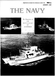
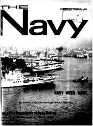
MrrCHELLU«MYp i v a l cereals with great flavourcanmake'emPace Four THE NAVY <strong>Nov</strong>ember-<strong>Dec</strong>ember-<strong>Jan</strong>uary, <strong>1971</strong>/72HYDROGRAPHtRSCOURSE— the survey <strong>of</strong>ficers who areexpected to carry out oceanographictasks with little or nosupervision, and the surveyrecorders who initially assist the<strong>of</strong>ficers and later, as seniorrecorders. shoulder moreresponsibility.The term oceanography covers amultitude <strong>of</strong> fields connected withthe ocean including its physicaldimensions and properties, itschemical composition, biology,meteorology and geologicalproperties.The detailed study <strong>of</strong> all thesesections, many <strong>of</strong> them scientificallynew. is beyond the scope <strong>of</strong> oneman. But the <strong>of</strong>ficer's course in 5months endeavours to cover asmany <strong>of</strong> these subjects as possibleso that students can select somefacet to study further.Additionally, as the HydrographicService <strong>of</strong> the R.A.N, is the primarycharting authority for the waters <strong>of</strong><strong>Australia</strong>. New Guinea and southernareas <strong>of</strong> the Pacific Ocean, emphasisis placed on the teaching <strong>of</strong> hydrographicsurveying at the school.The final product <strong>of</strong> the hydrographicsurvey is the published chartwhich goes on sale to internationalship owners and to a public withinterests such as yachting, fishing,skin diving or quiet Sunday boating.The hydrographic surveyor mustbe capable <strong>of</strong> producing a contouredpicture <strong>of</strong> the sea bed. delineatingthe coast line, accurately fixing theposition <strong>of</strong> submerged rocks andreefs — especially those dangerousto navigation. He must recogniseand chart all topographic featureswhich may help a mariner determinehis position.He must also understand tidaltheory and be able to analyse andpredict heights, and the times <strong>of</strong>high and low waters.He must record tidal stream andocean currents. The survey must beaccurately located on the earth'ssurface and the true meridian (northpoint) determined by astronomicalobservations <strong>of</strong> extreme precision.While a chart probably exists <strong>of</strong> anarea, it could be based on a surveyundertaken more than 100 years agoby surveyors undersail using aweight on a marked line todetermine the depth.For all their painstaking care andlong hours <strong>of</strong> work, surveyors <strong>of</strong>bygone days could not survey aseffectively or as accurately as is nowpossible with electronic echosounders, radio fixing systems andmechanical propulsion.The survey recorder has beendefined as a man among men and asailor among sailors. He is expectedto work long hours in the field <strong>of</strong>tenunder difficult and trying conditions.He may be a member <strong>of</strong> asounding boat's crew detached fromthe parent ship for extended periods,or based in a shore camp on aremote coral island operatingmodern electronic position-fixingequipment so that the survey ship— possibly 200 miles away — canaccurately and continuouslydetermine her position.To "The <strong>Navy</strong>",SUBSCRIPTION FORMBox C178, Clarence Street Post Olflce,Sydney. N.S.W., 2M0. <strong>Australia</strong>Alternatively, he<strong>of</strong> that ship's sur ey telin the collection o informsto advance scienti c knowlj^j^This could laU a i H j "observations, the measurement otthe intensity <strong>of</strong> the earth's magneticfield, characteristics <strong>of</strong> sea water atvarious depths, cores and dredgesamples <strong>of</strong> the bottom <strong>of</strong> the sea andplankton hauls.It is the business <strong>of</strong> the HydrographicSchool to ensure that themen conducting these tasks do sowith the pr<strong>of</strong>essionalism expectedby other world oceanographicauthorities.It may be said that the marinerplaces boundless confidence in thepublished chart and almostinvariably assumes that, where nodangers are shown, none in factexist.It is the surveyor's business to seethat this trust is not misplaced.I eadoie SI JO being '