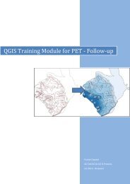
GIS-Training for Tsunami Evacuation Maps - GITEWS
GIS-Training for Tsunami Evacuation Maps - GITEWS
GIS-Training for Tsunami Evacuation Maps - GITEWS

Create successful ePaper yourself
Turn your PDF publications into a flip-book with our unique Google optimized e-Paper software.
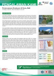
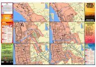
TRAINING MANUAL & REFERENCESThe documentation of the <strong>GIS</strong> training module contains a training manual <strong>for</strong>Quantum <strong>GIS</strong>, exercise data and additional in<strong>for</strong>mation regarding tsunami evacuationplanning.The related guideline “Recommendation <strong>for</strong> the layout of tsunami evacuation maps”provides a detailed description of elements to be considered in the maps as well asrespective symbols and colour codes.PRACTICAL EXPERIECES SO FARIn the frame of the PROTECTS project, one training course was implementedtargeting participants from NTB, Bali, Yogyakarta and East Java. It resulted in aconsiderable number of mapping products at district and sub-district levels.In addition to the hands-on approach during the training, the participants benefitedmost from establishing a network <strong>for</strong> continuous sharing and learning amongthemselves and the backstopping provided by technical advisors during the mapdevelopment. The backstopping was provided both via online communication as wellas in a follow up training session with the trainer.FURTHER IMPLEMENTATION OF TRAININGSDue to the fact that most Indonesian communities still lack a solid tsunami evacuationplan, there is definitely still a need to support evacuation planning processes,including the training of local professionals to strengthen mapping skills.To facilitate the further implementation of similar trainings, the <strong>Training</strong>Documentation and the Reference Document on the Layout of <strong>Evacuation</strong> <strong>Maps</strong> aremade available <strong>for</strong> interested parties. These materials will enable experienced <strong>GIS</strong>trainers (on Quantum <strong>GIS</strong> software) with basic background knowledge on tsunamievacuation planning to implement the developed module without further assistance.Nevertheless, it is to be asserted that <strong>for</strong> transfer and adaptation, it is recommendedto seek the assistance of experienced trainers. A list of trainers who played activeroles in implementing the manual <strong>for</strong> the PROTECTS project is provided below. The<strong>Training</strong> Module and related documentation was also handed over to BNPB.ACKNOWLEDGEMENTThe training module was developed and conducted by Patrick Oswald and RetnoAstrini (GIZ DeCGG & Bappeda NTB). The Reference Document on the Layout of<strong>Evacuation</strong> <strong>Maps</strong> is a joint ef<strong>for</strong>t led by Dewi Anggraeni from the PROTECTS team.The training was implemented in a joint program together with our partners from theBPBDs and working groups at provincial and district levels in Java, Bali and NTB.Authors:Published by:Further In<strong>for</strong>mation:Experienced Trainers:Harald Spahnharald.spahn@giz.deRahmi Yunitarahmi.yunita@giz.deDeutsche Gesellschaftfür InternationaleZusammenarbeit (GIZ)GmbHPhotos by:© GIZ IS – PROTECTSRetno AstriniGIZ Office JakartaMenara BCA 46 th FloorJln. M.H. Thamrin no. 1Jakarta 10310Tel.: +62 21 2358 7571Fax.: +62 21 2358 7570E: giz-indonesia@giz.deI: www.giz.de/indonesiawww.gitews.org/tsunami-kitBNPBPusdiklat PBKepala PusdiklatIr. B. Wisnu Widjaja, M.Sc.B.wisnu.w@bnpb.go.idB.wisnu.w@gmail.comwww.bnpb.go.idPatrick OswaldPatrick.Oswald@giz.deRetno Astriniretno.astrini@giz.de<strong>GITEWS</strong>/PROTECTSwww.gitews.org