GIS-Training for Tsunami Evacuation Maps - GITEWS
GIS-Training for Tsunami Evacuation Maps - GITEWS
GIS-Training for Tsunami Evacuation Maps - GITEWS

You also want an ePaper? Increase the reach of your titles
YUMPU automatically turns print PDFs into web optimized ePapers that Google loves.
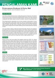
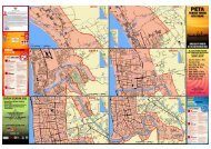
<strong>GIS</strong>-<strong>Training</strong> <strong>for</strong> <strong>Tsunami</strong> <strong>Evacuation</strong> <strong>Maps</strong>Strengthening Mapping Skills and Refining LayoutBACKGROUNDThe main outputs of any tsunami evacuation planning process are an evacuation mapand the related procedures. The evacuation maps explain about evacuation zones andstrategies, and are used <strong>for</strong> public in<strong>for</strong>mation. Most commonly, they are provided inprinted <strong>for</strong>m as maps, posters, flyers and billboards or are made available as digitalmedia (online). <strong>Evacuation</strong> maps must be easy to understand and presented in a waythat key in<strong>for</strong>mation is easy to memorize. There<strong>for</strong>e the design and layout of the maps isimportant.Although tsunami evacuation maps can be drawn manually, usually, digital maps arepreferred as they are more versatile in terms of presentation and modification in casechanges are needed.As part of the PROTECTS capacity development program, a training module has beenimplemented to support local stakeholders in producing good quality digital evacuationmaps.The basic Quantum <strong>GIS</strong>trainingABOUT THE TRAININGThe 5-day training is targeted to local stakeholders with some experience in <strong>GIS</strong> toimprove their mapping skills with special attention on the requirements of tsunamievacuation maps.The training is most effective when it is implemented back to back to on-going tsunamievacuation planning processes as participants can work on their own cases alreadyduring the training and apply the learning directly after the training in the on-goingprocesses.The topics covered by the training include a general understanding of geographicin<strong>for</strong>mation systems (<strong>GIS</strong>), working with spatial data and principles of cartography.Those topics are put into context by linking them to on-going tsunami evacuationplanning processes and explaining the use of digital maps in the different steps of suchplanning processes. When addressing the 5 step approach of evacuation planning theunderlying local tsunami hazard maps are reviewed and the concept of evacuationmaps is explained in more detail, including scale and generalization issues, necessaryelements to be shown on the map, the use of symbols and appropriate map layout.A major part of the training consists of a direct familiarization (hands on) with the <strong>GIS</strong>open source software, Quantum <strong>GIS</strong>, using evacuation planning outputs as exercisedata. The intensive one-week training shall be followed up by producing actual tsunamievacuation maps by the participants.The follow up trainingTechnical backstoppingIt is recommended to establish a mechanism <strong>for</strong> technical backstopping to supportparticipants when they implement the new skills back home in their working processesand to provide feedback and technical advice on the respective mapping products theypresent.Quantum <strong>GIS</strong> is free open source <strong>GIS</strong> software and is promoted together with OpenStreet Map and the plugin InaSAFE by BNPB / AIFDR.Billboard with evacuation mapproduced using Quantum <strong>GIS</strong>
TRAINING MANUAL & REFERENCESThe documentation of the <strong>GIS</strong> training module contains a training manual <strong>for</strong>Quantum <strong>GIS</strong>, exercise data and additional in<strong>for</strong>mation regarding tsunami evacuationplanning.The related guideline “Recommendation <strong>for</strong> the layout of tsunami evacuation maps”provides a detailed description of elements to be considered in the maps as well asrespective symbols and colour codes.PRACTICAL EXPERIECES SO FARIn the frame of the PROTECTS project, one training course was implementedtargeting participants from NTB, Bali, Yogyakarta and East Java. It resulted in aconsiderable number of mapping products at district and sub-district levels.In addition to the hands-on approach during the training, the participants benefitedmost from establishing a network <strong>for</strong> continuous sharing and learning amongthemselves and the backstopping provided by technical advisors during the mapdevelopment. The backstopping was provided both via online communication as wellas in a follow up training session with the trainer.FURTHER IMPLEMENTATION OF TRAININGSDue to the fact that most Indonesian communities still lack a solid tsunami evacuationplan, there is definitely still a need to support evacuation planning processes,including the training of local professionals to strengthen mapping skills.To facilitate the further implementation of similar trainings, the <strong>Training</strong>Documentation and the Reference Document on the Layout of <strong>Evacuation</strong> <strong>Maps</strong> aremade available <strong>for</strong> interested parties. These materials will enable experienced <strong>GIS</strong>trainers (on Quantum <strong>GIS</strong> software) with basic background knowledge on tsunamievacuation planning to implement the developed module without further assistance.Nevertheless, it is to be asserted that <strong>for</strong> transfer and adaptation, it is recommendedto seek the assistance of experienced trainers. A list of trainers who played activeroles in implementing the manual <strong>for</strong> the PROTECTS project is provided below. The<strong>Training</strong> Module and related documentation was also handed over to BNPB.ACKNOWLEDGEMENTThe training module was developed and conducted by Patrick Oswald and RetnoAstrini (GIZ DeCGG & Bappeda NTB). The Reference Document on the Layout of<strong>Evacuation</strong> <strong>Maps</strong> is a joint ef<strong>for</strong>t led by Dewi Anggraeni from the PROTECTS team.The training was implemented in a joint program together with our partners from theBPBDs and working groups at provincial and district levels in Java, Bali and NTB.Authors:Published by:Further In<strong>for</strong>mation:Experienced Trainers:Harald Spahnharald.spahn@giz.deRahmi Yunitarahmi.yunita@giz.deDeutsche Gesellschaftfür InternationaleZusammenarbeit (GIZ)GmbHPhotos by:© GIZ IS – PROTECTSRetno AstriniGIZ Office JakartaMenara BCA 46 th FloorJln. M.H. Thamrin no. 1Jakarta 10310Tel.: +62 21 2358 7571Fax.: +62 21 2358 7570E: giz-indonesia@giz.deI: www.giz.de/indonesiawww.gitews.org/tsunami-kitBNPBPusdiklat PBKepala PusdiklatIr. B. Wisnu Widjaja, M.Sc.B.wisnu.w@bnpb.go.idB.wisnu.w@gmail.comwww.bnpb.go.idPatrick OswaldPatrick.Oswald@giz.deRetno Astriniretno.astrini@giz.de<strong>GITEWS</strong>/PROTECTSwww.gitews.org