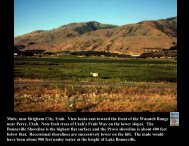
View of Snake River Plain north from Red Hill, Pocatello. Big ...
View of Snake River Plain north from Red Hill, Pocatello. Big ...
View of Snake River Plain north from Red Hill, Pocatello. Big ...

Create successful ePaper yourself
Turn your PDF publications into a flip-book with our unique Google optimized e-Paper software.
<strong>View</strong> <strong>of</strong> <strong>Snake</strong> <strong>River</strong> <strong>Plain</strong> <strong>north</strong> <strong>from</strong> <strong>Red</strong> <strong>Hill</strong>, <strong>Pocatello</strong>. <strong>Big</strong> Southern Butte is a composite rhyolite dome inleft center <strong>of</strong> view. In distance is the Lost <strong>River</strong> Range. The <strong>Snake</strong> <strong>River</strong> plain is covered with Pleistocenebasalt and sediment <strong>of</strong> the <strong>Snake</strong> <strong>River</strong> system. The ranges to the <strong>north</strong> are basin and range mountains.<strong>Pocatello</strong> is also in the Basin and Range province. The <strong>Snake</strong> <strong>River</strong> <strong>Plain</strong> cuts across the Basin and Range.
Map <strong>from</strong> Pierce and Morgan (1992), showing high topography, various zones <strong>of</strong> seismicity.Sites <strong>of</strong> calderas or volcanic fields. Topography is illustrated by color.
Map <strong>of</strong> the Eastern and western <strong>Snake</strong> <strong>River</strong> <strong>Plain</strong>, showing sites <strong>of</strong> volcanic fields.
17 Ma Columbia <strong>River</strong> basalt map. Note subdued topography <strong>of</strong> eastern Idaho andwestern location <strong>of</strong> the Continental Divide. Image courtesy <strong>of</strong> the U.S. Forest Service,Department <strong>of</strong> Agriculture.
17 Ma cross section across the western <strong>Snake</strong> <strong>River</strong> <strong>Plain</strong> Columbia <strong>River</strong> Basalt.Image courtesy <strong>of</strong> the U.S. Forest Service, Department <strong>of</strong> Agriculture.
<strong>View</strong> <strong>of</strong> Owyhee Mountains with Glenns Ferry Formation in the foreground <strong>of</strong> western<strong>Snake</strong> <strong>River</strong> <strong>Plain</strong>.
Bruneau <strong>River</strong> canyon. Pleistocene basalts lie above 15 Ma Jarbidge rhyolite,western <strong>Snake</strong> <strong>River</strong> <strong>Plain</strong>.
10 Ma map showing the Twin Falls and Picabo volcanic fields. Image courtesy <strong>of</strong> theU.S. Forest Service, Department <strong>of</strong> Agriculture.
10 Ma cross section across central <strong>Snake</strong> <strong>River</strong> <strong>Plain</strong>, showing intrusion <strong>of</strong> hot spot volcanism.Image courtesy <strong>of</strong> the U.S. Forest Service, Department <strong>of</strong> Agriculture.
<strong>View</strong> <strong>of</strong> Rock Creek Canyon south <strong>of</strong> Twin Falls. Rocks aretilted rhyolite ignimbrites <strong>of</strong> the Twin Falls volcanic field.
Rock Creek, in the Cassia Mountains. Rhyolites <strong>of</strong> Twin Falls volcanic field.
Shoshone Falls, rhyolites <strong>of</strong> late stage <strong>of</strong> Twin Falls volcanic fields.
Gooding City <strong>of</strong> Rocks. Rocks are 10 Ma rhyolites <strong>of</strong> the Twin Falls volcanic field.
Pliocene map with Heise volcanic field. Image courtesy <strong>of</strong> the U.S. Forest Service, Department <strong>of</strong>Agriculture.
4 Ma Pliocene cross section. Image courtesy <strong>of</strong> the U.S. Forest Service, Department <strong>of</strong> Agriculture.
Lithophysal rhyolites in the Walcott Tuff below the American Falls Dam. Basal vitrophyrehas devitrified.
Stratigraphic column <strong>of</strong> the Pliocene, Glenns Ferry Formation, deposited by Lake Idaho. Notevolcanic units interbedded, <strong>from</strong> the Heise Volcanic Field.
Spreading areas <strong>of</strong> <strong>Big</strong> Lost <strong>River</strong> and dike damming the <strong>Big</strong> Lost <strong>River</strong> on <strong>Snake</strong> <strong>River</strong> <strong>Plain</strong>.
<strong>Big</strong> Lost <strong>River</strong> playa system. Notice the loess and dryness <strong>of</strong> the landscape. <strong>Big</strong> SouthernButte in background.
<strong>View</strong> southwest across Lost <strong>River</strong> Playas with middle and east butte in skyline.
Windblown silt on a fire scar on <strong>Snake</strong> <strong>River</strong> <strong>Plain</strong>.
Map <strong>of</strong> basin and range faults and SRP basaltic fields.
Map showing <strong>Big</strong> Lost rift system, including the Great Rift, the Arco Rift Zone, the Lava Ridge-Hell’s Half Acre Rift Zone, and the Circular Butte-Kettle Butte Rift Zone.
False color remote image showing the Craters <strong>of</strong> the Moon lava field.
Edge <strong>of</strong> the Great Rift basaltic field.
Edge <strong>of</strong> Craters <strong>of</strong> the Moon Holocene lavas. Loess on south side <strong>of</strong> road.
Aerial view <strong>of</strong> <strong>Big</strong> Southern Butte. Also a dike along the Great Rift in mid-foreground.
Ground fissure in the King’s bowl fissure system.