GIS Seminar as a Basis for Cooperation on Teaching and ... - UMS
GIS Seminar as a Basis for Cooperation on Teaching and ... - UMS
GIS Seminar as a Basis for Cooperation on Teaching and ... - UMS

You also want an ePaper? Increase the reach of your titles
YUMPU automatically turns print PDFs into web optimized ePapers that Google loves.
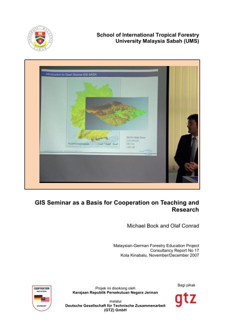
School of Internati<strong>on</strong>al Tropical Forestry<br />
University Malaysia Sabah (<strong>UMS</strong>)<br />
<str<strong>on</strong>g>GIS</str<strong>on</strong>g> <str<strong>on</strong>g>Seminar</str<strong>on</strong>g> <str<strong>on</strong>g>as</str<strong>on</strong>g> a B<str<strong>on</strong>g>as</str<strong>on</strong>g>is <str<strong>on</strong>g>for</str<strong>on</strong>g> <str<strong>on</strong>g>Cooperati<strong>on</strong></str<strong>on</strong>g> <strong>on</strong> <strong>Teaching</strong> <strong>and</strong><br />
Research<br />
Projek ini disok<strong>on</strong>g oleh<br />
Kerajaan Republik Persekutuan Negara Jerman<br />
Michael Bock <strong>and</strong> Olaf C<strong>on</strong>rad<br />
Malaysian-German Forestry Educati<strong>on</strong> Project<br />
C<strong>on</strong>sultancy Report No 17<br />
Kota Kinabalu, November/December 2007<br />
melalui<br />
Deutsche Gesellschaft für Technische Zusammenarbeit<br />
(GTZ) GmbH<br />
Bagi pihak
<str<strong>on</strong>g>GIS</str<strong>on</strong>g> <str<strong>on</strong>g>Seminar</str<strong>on</strong>g> <str<strong>on</strong>g>as</str<strong>on</strong>g> a B<str<strong>on</strong>g>as</str<strong>on</strong>g>is <str<strong>on</strong>g>for</str<strong>on</strong>g> a <str<strong>on</strong>g>Cooperati<strong>on</strong></str<strong>on</strong>g> <strong>on</strong> <strong>Teaching</strong> <strong>and</strong><br />
Research<br />
Michael Bock <strong>and</strong> Olaf C<strong>on</strong>rad<br />
November/December 2007<br />
Malaysian-German Forestry Educati<strong>on</strong> Project, School of Internati<strong>on</strong>al Tropical Forestry<br />
University Malaysia Sabah, Locked Bag 2073, 88999 Kota Kinabalu, Sabah, Malaysia<br />
Tel/Fax 0060/88/320658, Email: gtzpjb@ums.edu.my
27.-28. Nov.: Travelling<br />
Travelling from Hamburg to Kota Kinabalu via Frankfurt (Main) <strong>and</strong> Singapore.<br />
29.-30. Nov.: First C<strong>on</strong>tacts<br />
On the first day introducti<strong>on</strong> talks to the staff members were <strong>on</strong> the schedule. In the<br />
afterno<strong>on</strong> a visit to the dean Assoc. Prof. Dr. Mahmud Sudin of the SITF w<str<strong>on</strong>g>as</str<strong>on</strong>g> <strong>on</strong> the<br />
schedule. He in<str<strong>on</strong>g>for</str<strong>on</strong>g>med Mr. Bock that to his regret he is not able to take part in the 3-days<br />
<str<strong>on</strong>g>GIS</str<strong>on</strong>g> seminar because of his numerous dates. Afterwards first talks about research activities<br />
of the school <strong>and</strong> available geo data with Dr. Phua Mui-How <strong>and</strong> Dr. Andy Russel Immit<br />
Mojiol could be held.<br />
1. Dec.: Day Trip to Kli<str<strong>on</strong>g>as</str<strong>on</strong>g> Peninsula<br />
Preliminary field trip to <strong>on</strong>e possible study area (Kli<str<strong>on</strong>g>as</str<strong>on</strong>g> Peninsula). The Kli<str<strong>on</strong>g>as</str<strong>on</strong>g> Peninsula, about<br />
60km south of Kota Kinabalu, is a 40 * 30 km flat spit sticking into the South Chinese Sea. In<br />
the l<str<strong>on</strong>g>as</str<strong>on</strong>g>t decades it suffered from enormous l<strong>and</strong> use pressure, because of its good<br />
accessibleness <strong>and</strong> its flat terrain that makes it e<str<strong>on</strong>g>as</str<strong>on</strong>g>y to build up agro-<str<strong>on</strong>g>for</str<strong>on</strong>g>estry systems <str<strong>on</strong>g>as</str<strong>on</strong>g><br />
rubber <strong>and</strong> oil palm plantati<strong>on</strong>. Still Kli<str<strong>on</strong>g>as</str<strong>on</strong>g> Peninsula is also home of remaining stocks of peat<br />
swamp <str<strong>on</strong>g>for</str<strong>on</strong>g>ests, which have been declared <str<strong>on</strong>g>as</str<strong>on</strong>g> <str<strong>on</strong>g>for</str<strong>on</strong>g>est protecti<strong>on</strong> area. This <str<strong>on</strong>g>for</str<strong>on</strong>g>est type is the<br />
most important carb<strong>on</strong> storage am<strong>on</strong>g all tropical <str<strong>on</strong>g>for</str<strong>on</strong>g>est types <strong>and</strong> so in times of climate<br />
change the studying of this ecosystem to protect or even to per<str<strong>on</strong>g>for</str<strong>on</strong>g>m a re<str<strong>on</strong>g>for</str<strong>on</strong>g>estati<strong>on</strong> of the<br />
stocks is an urgent need. These facts are known in the SITF since many years. Particularly<br />
SITF staff member Dr. Phua h<str<strong>on</strong>g>as</str<strong>on</strong>g> a research focus <strong>on</strong> analysing the re<str<strong>on</strong>g>as</str<strong>on</strong>g><strong>on</strong>s <strong>and</strong><br />
repercussi<strong>on</strong>s of <str<strong>on</strong>g>for</str<strong>on</strong>g>est fires, which occur since the late 1980s in dry El Nino years. To get a<br />
first impressi<strong>on</strong> of the l<strong>and</strong>scape Dr. Fischer <strong>and</strong> Mr. Bock visited the Kli<str<strong>on</strong>g>as</str<strong>on</strong>g> Peninsula.<br />
Fig. 1: Remaining stock of peat swamp <str<strong>on</strong>g>for</str<strong>on</strong>g>est<br />
in the background<br />
Fig. 2: Typical housing <strong>on</strong> Kli<str<strong>on</strong>g>as</str<strong>on</strong>g> peninsula<br />
2. Dec.: <str<strong>on</strong>g>Seminar</str<strong>on</strong>g> Preparati<strong>on</strong><br />
Dr. C<strong>on</strong>rad arrived in the early morning short after midnight at Kota Kinabalu Internati<strong>on</strong>al<br />
Airport.<br />
This day had to be used <str<strong>on</strong>g>for</str<strong>on</strong>g> final preparati<strong>on</strong>s <strong>and</strong> adaptati<strong>on</strong>s of documents <strong>and</strong> materials<br />
<str<strong>on</strong>g>for</str<strong>on</strong>g> the <str<strong>on</strong>g>GIS</str<strong>on</strong>g> seminar. This became necessary, because it turned out that many of the seminar<br />
participants had not even <strong>on</strong>ly small or n<strong>on</strong>e <str<strong>on</strong>g>GIS</str<strong>on</strong>g> pre-knowledge but also limited computer<br />
skills in general.<br />
The computers to be used by the participants had been rented specifically <str<strong>on</strong>g>for</str<strong>on</strong>g> the seminar<br />
from an external computer hardware service. There<str<strong>on</strong>g>for</str<strong>on</strong>g>e the c<strong>on</strong>structi<strong>on</strong> of the CIP
envir<strong>on</strong>ment in the SITF’s seminar room w<str<strong>on</strong>g>as</str<strong>on</strong>g> accompanied <strong>and</strong> an inspecti<strong>on</strong> of the installed<br />
computer equipment h<str<strong>on</strong>g>as</str<strong>on</strong>g> been d<strong>on</strong>e. Minor technical hardware problems could be solved<br />
immediately. A WLAN h<str<strong>on</strong>g>as</str<strong>on</strong>g> been set up to give the seminar participants access to a comm<strong>on</strong><br />
data exchange directory. Pre-installati<strong>on</strong> of software <strong>and</strong> data materials caused no further<br />
problems.<br />
3.-5. Dec.: <str<strong>on</strong>g>Seminar</str<strong>on</strong>g><br />
One of the main t<str<strong>on</strong>g>as</str<strong>on</strong>g>ks of the c<strong>on</strong>sultancy w<str<strong>on</strong>g>as</str<strong>on</strong>g> the holding of a 3-day seminar in Geographic<br />
In<str<strong>on</strong>g>for</str<strong>on</strong>g>mati<strong>on</strong> Systems (<str<strong>on</strong>g>GIS</str<strong>on</strong>g>). The seminar aimed at introducing the participants to special<br />
<str<strong>on</strong>g>as</str<strong>on</strong>g>pects of spatial data, which are in the focus of <str<strong>on</strong>g>GIS</str<strong>on</strong>g>. It w<str<strong>on</strong>g>as</str<strong>on</strong>g> to be suggestive <strong>on</strong> <str<strong>on</strong>g>GIS</str<strong>on</strong>g><br />
techniques, particularly to dem<strong>on</strong>strate how scientific questi<strong>on</strong>s can be solved using various<br />
<str<strong>on</strong>g>GIS</str<strong>on</strong>g> analysis tools. The <str<strong>on</strong>g>GIS</str<strong>on</strong>g> software used explicitly in the seminar is the free <strong>and</strong> open<br />
source software SAGA (System <str<strong>on</strong>g>for</str<strong>on</strong>g> Automated Geoscientific Analyses) <strong>and</strong> had also an<br />
emph<str<strong>on</strong>g>as</str<strong>on</strong>g>is <strong>on</strong> acquisiti<strong>on</strong> <strong>and</strong> usage of various data available free of charge. Both had been<br />
chosen to enable the participants to per<str<strong>on</strong>g>for</str<strong>on</strong>g>m spatial analyses independently <strong>on</strong> their own <strong>and</strong><br />
to exploit free data sources relevant to <str<strong>on</strong>g>for</str<strong>on</strong>g>estry.<br />
Table 1: <str<strong>on</strong>g>Seminar</str<strong>on</strong>g> c<strong>on</strong>tents<br />
Day Topic C<strong>on</strong>tents<br />
3.Dec. General Introducti<strong>on</strong> Introducing the lecturers <strong>and</strong> their research are<str<strong>on</strong>g>as</str<strong>on</strong>g>, the<br />
University of Hamburg with the Dept. of Physical<br />
Geography, <strong>and</strong> giving a course outline.<br />
<str<strong>on</strong>g>GIS</str<strong>on</strong>g> <strong>and</strong> SAGA Theoretical backgrounds to geodata, Geographic<br />
In<str<strong>on</strong>g>for</str<strong>on</strong>g>mati<strong>on</strong> Systems (<str<strong>on</strong>g>GIS</str<strong>on</strong>g>) <strong>and</strong> the free open source <str<strong>on</strong>g>GIS</str<strong>on</strong>g><br />
software SAGA<br />
First Steps Installing <strong>and</strong> executing SAGA, functi<strong>on</strong>ality of the<br />
Graphical User Interface (GUI), loading <strong>and</strong> saving data,<br />
data visualisati<strong>on</strong><br />
Data Structures Vector <strong>and</strong> r<str<strong>on</strong>g>as</str<strong>on</strong>g>ter data, accessing different data file<br />
Cartographic<br />
Projecti<strong>on</strong>s<br />
<str<strong>on</strong>g>for</str<strong>on</strong>g>mats, special visualisati<strong>on</strong> opti<strong>on</strong>s, free data sources<br />
Why we need map projecti<strong>on</strong>s <strong>and</strong> what it is. Choosing<br />
appropriate map projecti<strong>on</strong>s. Specialities of r<str<strong>on</strong>g>as</str<strong>on</strong>g>ter data<br />
projecti<strong>on</strong>s.<br />
4.Dec. Georeferencing Applicati<strong>on</strong> of the georeferencing procedure <strong>on</strong> scanned<br />
topographic maps<br />
Digitising Creating vector data by manual <strong>and</strong> automatic<br />
Working with Vector<br />
Data<br />
digitisati<strong>on</strong><br />
St<strong>and</strong>ard tools <str<strong>on</strong>g>for</str<strong>on</strong>g> vector data analyses <strong>and</strong><br />
manipulati<strong>on</strong>s. Intersecti<strong>on</strong>, uni<strong>on</strong>, buffer z<strong>on</strong>es, c<strong>on</strong>tour<br />
line derivati<strong>on</strong>.<br />
Working with R<str<strong>on</strong>g>as</str<strong>on</strong>g>ter St<strong>and</strong>ard tools <str<strong>on</strong>g>for</str<strong>on</strong>g> r<str<strong>on</strong>g>as</str<strong>on</strong>g>ter data analyses <strong>and</strong><br />
Data<br />
manipulati<strong>on</strong>s. R<str<strong>on</strong>g>as</str<strong>on</strong>g>ter calculator, merging <strong>and</strong> splitting,<br />
5.Dec. R<str<strong>on</strong>g>as</str<strong>on</strong>g>ter Interpolati<strong>on</strong> Creating r<str<strong>on</strong>g>as</str<strong>on</strong>g>ter data from scattered point samples.<br />
Digital Terrain Models (DTM), Nearest Neighbour,<br />
Triangulati<strong>on</strong>, Inverse Distance to a Power, Modified<br />
Shepard, Spline Interpolati<strong>on</strong><br />
Image Analysis Colour composites, filter operators, vegetati<strong>on</strong> indices,<br />
supervised <strong>and</strong> unsupervised l<strong>and</strong> cover cl<str<strong>on</strong>g>as</str<strong>on</strong>g>sificati<strong>on</strong>.<br />
Terrain Analysis Digital terrain analysis, local morphometry (e.g. slope,<br />
<str<strong>on</strong>g>as</str<strong>on</strong>g>pect, curvatures), hydrologic terrain parameters, hill<br />
shading, view shed analysis.<br />
Statistical Analyses Neighbourhood analysis, single <strong>and</strong> multiple regressi<strong>on</strong><br />
analysis, variogram modelling, ordinary <strong>and</strong> universal<br />
Kriging interpolati<strong>on</strong>
Data chosen <strong>and</strong> prepared <str<strong>on</strong>g>for</str<strong>on</strong>g> the seminar have been located <str<strong>on</strong>g>for</str<strong>on</strong>g> the area of Malaysia where<br />
possible to show the participants relati<strong>on</strong>s to their pers<strong>on</strong>al situati<strong>on</strong> <strong>and</strong> research are<str<strong>on</strong>g>as</str<strong>on</strong>g>.<br />
Likewise examples have been chosen from existent projects to dem<strong>on</strong>strate the practicability<br />
of spatial analysis <str<strong>on</strong>g>as</str<strong>on</strong>g> far <str<strong>on</strong>g>as</str<strong>on</strong>g> possible. The seminar c<strong>on</strong>tents are listed in Table 1.<br />
Evaluati<strong>on</strong> Discussi<strong>on</strong><br />
The closing evaluati<strong>on</strong> discussi<strong>on</strong> gave us feedback from the participant’s seminar<br />
impressi<strong>on</strong>s. Generally a positive feedback h<str<strong>on</strong>g>as</str<strong>on</strong>g> been uttered. Some expressed that the<br />
speed of the less<strong>on</strong>s w<str<strong>on</strong>g>as</str<strong>on</strong>g> too high so they sometimes were lost. But it w<str<strong>on</strong>g>as</str<strong>on</strong>g> also menti<strong>on</strong>ed<br />
that most of the times this h<str<strong>on</strong>g>as</str<strong>on</strong>g> been recognized by the trainers, who could lead them back<br />
again. Actually, this is a situati<strong>on</strong> to be expected, when many participants with different<br />
knowledge are joined in <strong>on</strong>e course.<br />
C<strong>on</strong>clusi<strong>on</strong><br />
From the trainer’s point of view the sum up of the 3 days <str<strong>on</strong>g>GIS</str<strong>on</strong>g> seminar implies the following:<br />
The dem<strong>on</strong>strated methods <strong>and</strong> the shown data sources were relevant <str<strong>on</strong>g>for</str<strong>on</strong>g> most of<br />
the participants especially <str<strong>on</strong>g>for</str<strong>on</strong>g> m<str<strong>on</strong>g>as</str<strong>on</strong>g>ter students. In c<strong>on</strong>tr<str<strong>on</strong>g>as</str<strong>on</strong>g>t the job specificati<strong>on</strong> of<br />
some of the participants of the SITF (<str<strong>on</strong>g>for</str<strong>on</strong>g> instance members of the administrative staff)<br />
did not include activities, where the shown methods (geodata analysis) give a real<br />
benefit. This h<str<strong>on</strong>g>as</str<strong>on</strong>g> to be kept in mind in future <str<strong>on</strong>g>for</str<strong>on</strong>g> the invitati<strong>on</strong> of participants <str<strong>on</strong>g>for</str<strong>on</strong>g> similar<br />
events.<br />
The number of participants w<str<strong>on</strong>g>as</str<strong>on</strong>g> adequate, so effective teaching sessi<strong>on</strong>s could be<br />
per<str<strong>on</strong>g>for</str<strong>on</strong>g>med.<br />
The motivati<strong>on</strong> of the participants w<str<strong>on</strong>g>as</str<strong>on</strong>g> relatively high. Those who saw the benefit <str<strong>on</strong>g>for</str<strong>on</strong>g><br />
their own <str<strong>on</strong>g>as</str<strong>on</strong>g>signments or their m<str<strong>on</strong>g>as</str<strong>on</strong>g>ter thesis learned a lot in these three days.<br />
The precogniti<strong>on</strong> of the participants w<str<strong>on</strong>g>as</str<strong>on</strong>g> very different. A more homogenous group<br />
regarding the participant’s skills of computer techniques would have led to an even<br />
more effective teaching.<br />
a) b)<br />
Fig. 3: <str<strong>on</strong>g>Seminar</str<strong>on</strong>g> room during the workshop<br />
<str<strong>on</strong>g>Seminar</str<strong>on</strong>g> Finish <strong>and</strong> Graduati<strong>on</strong><br />
The closing event of the 3 days seminar <strong>on</strong> <str<strong>on</strong>g>GIS</str<strong>on</strong>g> <strong>and</strong> geodata took place in a restaurant,<br />
which created a friendly atmosphere not <strong>on</strong>ly <str<strong>on</strong>g>for</str<strong>on</strong>g> h<strong>and</strong>ing over a course certificate to each<br />
participant. After this official part a delicious meal h<str<strong>on</strong>g>as</str<strong>on</strong>g> been served <strong>and</strong> first discussi<strong>on</strong>s<br />
about a future cooperati<strong>on</strong> began.
Fig. 4: Group photo of seminar participants<br />
a) b)<br />
Fig. 5:Official seminar graduati<strong>on</strong>. Also the lecturers have been h<strong>on</strong>oured <strong>and</strong> got a small present<br />
h<strong>and</strong>ed over by Dr. Phua: a) M. Bock , b) O. C<strong>on</strong>rad<br />
6. Dec.: Discussing Future <str<strong>on</strong>g>Cooperati<strong>on</strong></str<strong>on</strong>g><br />
For further impressi<strong>on</strong>s of the <str<strong>on</strong>g>for</str<strong>on</strong>g>ests of Borneo this morning Dr. Fischer took Dr. C<strong>on</strong>rad <strong>and</strong><br />
Mr. Bock to the Kota Kinabalu Wetl<strong>and</strong> Center. This refuge of natural mangrove vegetati<strong>on</strong><br />
<strong>and</strong> wildlife is located in the direct neighbourhood of the densely populated housing area of<br />
the city <strong>and</strong> there<str<strong>on</strong>g>for</str<strong>on</strong>g>e is quite in danger. A private organisati<strong>on</strong> carries <strong>on</strong> the centre. The<br />
work is mostly d<strong>on</strong>e by volunteers, who keep the areal clean, provide in<str<strong>on</strong>g>for</str<strong>on</strong>g>mati<strong>on</strong> <str<strong>on</strong>g>for</str<strong>on</strong>g> visitors<br />
<strong>and</strong> do some research <strong>on</strong> mangrove species.<br />
In the late morning a meeting with partners from SITF about cooperati<strong>on</strong> possibilities in<br />
different research fields w<str<strong>on</strong>g>as</str<strong>on</strong>g> <strong>on</strong> the schedule. Beside the c<strong>on</strong>sultants <strong>and</strong> Dr. Michael<br />
Fischer also Dr. Phua Mui-How, Dr. Andy Russel, Dr. John Tay, Dr. Norma <str<strong>on</strong>g>as</str<strong>on</strong>g> well <str<strong>on</strong>g>as</str<strong>on</strong>g> a few<br />
SITF students attended the meeting.<br />
Assoc. Prof. Dr. John Tay <str<strong>on</strong>g>as</str<strong>on</strong>g> head of the SITF research programme gave an overview about<br />
the structure of the school <strong>and</strong> their <strong>on</strong>going research activities in different fields of <str<strong>on</strong>g>for</str<strong>on</strong>g>est<br />
sciences. After this introducti<strong>on</strong> the floor w<str<strong>on</strong>g>as</str<strong>on</strong>g> opened <str<strong>on</strong>g>for</str<strong>on</strong>g> discussi<strong>on</strong>.
As c<strong>on</strong>clusi<strong>on</strong> the attendees agreed <strong>on</strong> the fixati<strong>on</strong> of a research field that deals with several<br />
important research topics relevant <str<strong>on</strong>g>for</str<strong>on</strong>g> the SITF: changing c<strong>on</strong>diti<strong>on</strong>s <str<strong>on</strong>g>for</str<strong>on</strong>g> <str<strong>on</strong>g>for</str<strong>on</strong>g>est <strong>and</strong> <str<strong>on</strong>g>for</str<strong>on</strong>g>est<br />
management due to climate <strong>and</strong> l<strong>and</strong> use change with regard to carb<strong>on</strong> storages <strong>and</strong> carb<strong>on</strong><br />
trading, both topics that will be of utmost importance <str<strong>on</strong>g>for</str<strong>on</strong>g> tropical countries like Malaysia in the<br />
near future. A modelling perspective of the topics can be yielded by the working group of the<br />
Hamburg University with the head Prof. Dr. Jürgen Böhner.<br />
a)<br />
b)<br />
Fig. 6: Kota Kinabalu Wetl<strong>and</strong> Centre. Typical habitus of tree species in a mangrove <str<strong>on</strong>g>for</str<strong>on</strong>g>est. The<br />
roots undertake many functi<strong>on</strong>s, e.g. sustaining of the plants in the different situati<strong>on</strong>s of<br />
the tides (a, b), sign of a typical mangrove wildlife: entrance to the residence of a mud<br />
lobster (c)<br />
Such a bigger project needs a l<strong>on</strong>g <str<strong>on</strong>g>for</str<strong>on</strong>g>erun since proposals have to be written <strong>and</strong> submitted<br />
to suitable funding organisati<strong>on</strong>s, who in turn take some time to decide about the funding.<br />
There<str<strong>on</strong>g>for</str<strong>on</strong>g>e Dr. Phua <strong>and</strong> Dr. C<strong>on</strong>rad agreed to c<strong>on</strong>duct a ‘mini’ project following a proposal by<br />
Dr. Fischer.<br />
The project shall focus <strong>on</strong> <str<strong>on</strong>g>for</str<strong>on</strong>g>est fragmentati<strong>on</strong> analysis b<str<strong>on</strong>g>as</str<strong>on</strong>g>ed <strong>on</strong> satellite imagery of Kli<str<strong>on</strong>g>as</str<strong>on</strong>g><br />
Peninsula. Several dates shall be compared to point out the radical changes caused by<br />
<str<strong>on</strong>g>for</str<strong>on</strong>g>est fires during the dry El Nino year 1999. Data acquisiti<strong>on</strong>, preparati<strong>on</strong> <strong>and</strong> l<strong>and</strong> cover<br />
cl<str<strong>on</strong>g>as</str<strong>on</strong>g>sificati<strong>on</strong> shall be d<strong>on</strong>e by Dr. Phua where<str<strong>on</strong>g>as</str<strong>on</strong>g> Dr. C<strong>on</strong>rad h<str<strong>on</strong>g>as</str<strong>on</strong>g> the resp<strong>on</strong>sibility <str<strong>on</strong>g>for</str<strong>on</strong>g> the<br />
development <strong>and</strong> implementati<strong>on</strong> of the fragmentati<strong>on</strong> analysis. Figure 8 shows first results<br />
of l<strong>and</strong> cover cl<str<strong>on</strong>g>as</str<strong>on</strong>g>sificati<strong>on</strong> per<str<strong>on</strong>g>for</str<strong>on</strong>g>med by Dr. Phua. It is further planned to publish the results<br />
<str<strong>on</strong>g>as</str<strong>on</strong>g> paper <strong>and</strong> to give a presentati<strong>on</strong> at the C<strong>on</strong>ference <strong>on</strong> Applied Geoin<str<strong>on</strong>g>for</str<strong>on</strong>g>matics AGIT 2008<br />
in Salzburg, Austria, which will be held in the beginning of July 2008.<br />
c)
Fig. 7: Forest Status of Sabah (World Wildlife Fund 2005, ‘Borneo: Tre<str<strong>on</strong>g>as</str<strong>on</strong>g>ure Isl<strong>and</strong> at Risk’,<br />
http://<str<strong>on</strong>g>as</str<strong>on</strong>g>sets.p<strong>and</strong>a.org/downloads/tre<str<strong>on</strong>g>as</str<strong>on</strong>g>ureisl<strong>and</strong>atrisk.pdf )<br />
Fig. 8: L<strong>and</strong> cover cl<str<strong>on</strong>g>as</str<strong>on</strong>g>sificati<strong>on</strong> b<str<strong>on</strong>g>as</str<strong>on</strong>g>ed <strong>on</strong> satellite imagery (L<strong>and</strong>Sat) <str<strong>on</strong>g>for</str<strong>on</strong>g> the years 1985<br />
<strong>and</strong> 1999.
7.-8. Dec.: Field Trip<br />
Day 1: Kli<str<strong>on</strong>g>as</str<strong>on</strong>g> Peninsula<br />
On the first day of the field trip the focus w<str<strong>on</strong>g>as</str<strong>on</strong>g> <strong>on</strong> the lowl<strong>and</strong> <str<strong>on</strong>g>for</str<strong>on</strong>g>ests of Kli<str<strong>on</strong>g>as</str<strong>on</strong>g> Peninsula. The<br />
mangrove <strong>and</strong> peat swamp <str<strong>on</strong>g>for</str<strong>on</strong>g>ests are in heavy l<strong>and</strong> use c<strong>on</strong>flicts due to the ec<strong>on</strong>omic<br />
incentive that is offered by c<strong>on</strong>versi<strong>on</strong> into rubber or oil palm plantati<strong>on</strong>. The local <str<strong>on</strong>g>for</str<strong>on</strong>g>est<br />
authorities try to protect the remaining pristine <str<strong>on</strong>g>for</str<strong>on</strong>g>ests <strong>and</strong> also start to af<str<strong>on</strong>g>for</str<strong>on</strong>g>est degraded<br />
are<str<strong>on</strong>g>as</str<strong>on</strong>g>. These ef<str<strong>on</strong>g>for</str<strong>on</strong>g>ts but also the losses of <str<strong>on</strong>g>for</str<strong>on</strong>g>est are<str<strong>on</strong>g>as</str<strong>on</strong>g> were presented to the attendees of<br />
the field trip by local <str<strong>on</strong>g>for</str<strong>on</strong>g>est department staff <strong>on</strong> day <strong>on</strong>e.<br />
a) b)<br />
Fig. 9: a) Binsuluk Forest Reserve in the northern part of the Kli<str<strong>on</strong>g>as</str<strong>on</strong>g> Peninsula, a remaining<br />
pristine peat swamp <str<strong>on</strong>g>for</str<strong>on</strong>g>est. b) rubber plantati<strong>on</strong><br />
a) b) c) d)<br />
Fig. 10: Kli<str<strong>on</strong>g>as</str<strong>on</strong>g> Forest Reserve. Drainage ditches were laid out to prepare the <str<strong>on</strong>g>for</str<strong>on</strong>g>mer peat<br />
swamp <str<strong>on</strong>g>for</str<strong>on</strong>g>est area <str<strong>on</strong>g>for</str<strong>on</strong>g> use <str<strong>on</strong>g>as</str<strong>on</strong>g> plantati<strong>on</strong> (a), attempts to af<str<strong>on</strong>g>for</str<strong>on</strong>g>est a degraded (in this<br />
c<str<strong>on</strong>g>as</str<strong>on</strong>g>e burned) area (b, c), m<strong>on</strong>itoring of the peat thickness due to ph<str<strong>on</strong>g>as</str<strong>on</strong>g>ing out after<br />
lowering the groundwater level (d)
a) b)<br />
Fig. 11: One of the main causes <str<strong>on</strong>g>for</str<strong>on</strong>g> c<strong>on</strong>versi<strong>on</strong> of lowl<strong>and</strong> <str<strong>on</strong>g>for</str<strong>on</strong>g>ests is the earning power of<br />
plantati<strong>on</strong>s: Oil palm plantati<strong>on</strong> (a) <strong>and</strong> harvest of the fruits (b)<br />
Day 2: Crocker Range<br />
Sabah's <str<strong>on</strong>g>for</str<strong>on</strong>g>ests are also home to the largest flower in the world, the gigantic Rafflesia,<br />
usually occurring in undisturbed hill <str<strong>on</strong>g>for</str<strong>on</strong>g>est. Few locati<strong>on</strong>s exist in Sabah where these<br />
f<str<strong>on</strong>g>as</str<strong>on</strong>g>cinating plants are known to occur. Most of these sites are now fully protected to prevent<br />
the extincti<strong>on</strong> of these unique species (Sabah Forestry Department 2007,<br />
http://www.<str<strong>on</strong>g>for</str<strong>on</strong>g>est.sabah.gov.my ).<br />
Visiting the locati<strong>on</strong> of Rafflesia w<str<strong>on</strong>g>as</str<strong>on</strong>g> <strong>on</strong>e of the highlights of the sec<strong>on</strong>d day. Others were the<br />
presentati<strong>on</strong> about the Crocker Range Nati<strong>on</strong>al Park held by a Park Ranger, the short hike<br />
into the <str<strong>on</strong>g>for</str<strong>on</strong>g>est reserve <strong>and</strong> the visit to a local rice wine brewery.<br />
a) b) c)<br />
Fig. 12: Crocker Range: a) Bamboo undergrowth <str<strong>on</strong>g>as</str<strong>on</strong>g> a sign <str<strong>on</strong>g>for</str<strong>on</strong>g> beginning <str<strong>on</strong>g>for</str<strong>on</strong>g>est degradati<strong>on</strong>.<br />
b) Rafflesia spec. exemplar short after blooming. c) Also the mountainous <str<strong>on</strong>g>for</str<strong>on</strong>g>ests<br />
are in danger: laying out terraces <str<strong>on</strong>g>for</str<strong>on</strong>g> plantati<strong>on</strong> (behind the banana leafs)<br />
9.-10. Dec.: Travelling<br />
In the late morning of 9 th December travelling back to Hamburg w<str<strong>on</strong>g>as</str<strong>on</strong>g> <strong>on</strong> the schedule. The<br />
c<strong>on</strong>sultants arrived in the early morning of 10 th December.