The State of Water in Kosovo, 2010
The State of Water in Kosovo, 2010 The State of Water in Kosovo, 2010
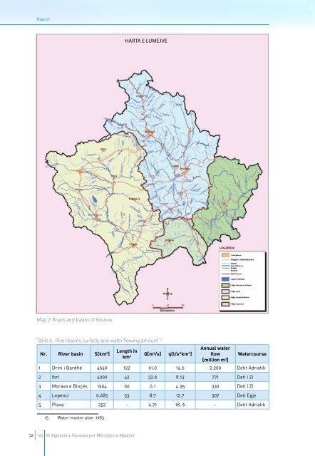
RaportHARTA E LUMEJVEMap 2: Rivers and basins of KosovoTable 6 . River basins, surface, and water flowing amount 15Nr. River basin S[km 2 ]Length inkm 2 Q[m 3 /s] q[l/s*km 2 ]Annual waterflow[million m 3 ]Watercourse1 Drini i Bardhë 4649 122 61.0 14.6 2.200 Detit Adriatik2 Ibri 4009 42 32.6 8.13 771 Deti i Zi3 Morava e Binçës 1564 60 6.1 4.35 330 Deti i Zi4 Lepenci 0.685 53 8.7 12.7 307 Deti Egje5 Plava 252 - 4.71 18. 6 - Detit Adriatik15 Water master plan 198332120 © Agjencia e Kosoves per Mbrojtjen e Mjedisit
Gjendja e Ujërave në KosovëHARTA E PELLGJEVE DHE NëNPELLGJEVE LUMOREmmph&departamenti i ujraveMap 3: River basins and sub-basins© Agjencia e Kosoves per Mbrojtjen e Mjedisit33120
- Page 3 and 4: MINISTRY OF ENVIRONMENT AND SPATIAL
- Page 10 and 11: RaportINDEX OF FIGURESFigure 1:Exte
- Page 14 and 15: Raport14 120 © Agjencia e Kosoves
- Page 16 and 17: Raport1.2.2. ReliefKosovo is a moun
- Page 18 and 19: Raport1.2.2. POPULATION STRUCTUREFo
- Page 20 and 21: Raport20 120 © Agjencia e Kosoves
- Page 22 and 23: RaportAdministrative instruction un
- Page 24 and 25: Raport2.1.5 EUROPEAN UNION DIRECTIV
- Page 26 and 27: Raport2.2.4 KOSOVO HYDRO-METEOROLOG
- Page 28 and 29: RaportDuties and responsibilities o
- Page 30 and 31: Raport30 120 © Agjencia e Kosoves
- Page 34 and 35: RaportMap 4: Map of hydrometric sta
- Page 36 and 37: RaportTable 8: Positive and negativ
- Page 38 and 39: RaportMap 5: Existing and planned w
- Page 40 and 41: Raport3.2 GROUND WATERSGroundwater
- Page 42 and 43: RaportCarstic aquifers - The carsti
- Page 44 and 45: Raport3.3 THERMAL AND MINERAL WATES
- Page 46 and 47: RaportMap 8: Some thermal-mineral w
- Page 48 and 49: Raportshimatsit manuelMap 9: Manual
- Page 50 and 51: RaportMap 10: Distribution of rainf
- Page 52 and 53: Raport52 120 © Agjencia e Kosoves
- Page 54 and 55: Raportabove, it is estimated that t
- Page 56 and 57: RaportThe spring of Drini i Bardhë
- Page 59 and 60: Gjendja e Ujërave në Kosovë4.2 T
- Page 61 and 62: Gjendja e Ujërave në KosovëIn th
- Page 63 and 64: Gjendja e Ujërave në Kosovë4.3 T
- Page 65 and 66: Gjendja e Ujërave në KosovëTable
- Page 67 and 68: Gjendja e Ujërave në KosovëMap 1
- Page 69 and 70: Gjendja e Ujërave në KosovëMap 1
- Page 71 and 72: Gjendja e Ujërave në KosovëMap 1
- Page 73 and 74: Gjendja e Ujërave në Kosovë5. ER
- Page 75 and 76: Gjendja e Ujërave në KosovëMap 1
- Page 77 and 78: Gjendja e Ujërave në KosovëMap 1
- Page 79 and 80: Gjendja e Ujërave në Kosovë6. WA
- Page 81 and 82: Gjendja e Ujërave në Kosovë6.3 W
RaportHARTA E LUMEJVEMap 2: Rivers and bas<strong>in</strong>s <strong>of</strong> <strong>Kosovo</strong>Table 6 . River bas<strong>in</strong>s, surface, and water flow<strong>in</strong>g amount 15Nr. River bas<strong>in</strong> S[km 2 ]Length <strong>in</strong>km 2 Q[m 3 /s] q[l/s*km 2 ]Annual waterflow[million m 3 ]<strong>Water</strong>course1 Dr<strong>in</strong>i i Bardhë 4649 122 61.0 14.6 2.200 Detit Adriatik2 Ibri 4009 42 32.6 8.13 771 Deti i Zi3 Morava e B<strong>in</strong>çës 1564 60 6.1 4.35 330 Deti i Zi4 Lepenci 0.685 53 8.7 12.7 307 Deti Egje5 Plava 252 - 4.71 18. 6 - Detit Adriatik15 <strong>Water</strong> master plan 198332120 © Agjencia e Kosoves per Mbrojtjen e Mjedisit


