SOIL SURVEY
SOIL SURVEY SOIL SURVEY
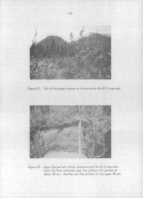
Figure 22 . Rego Gleysol soil which characterized the BC 3 map unit .Note the finer materials near the surface with gravels a t- about 30 cm . Mottles are also evident in the upper 30 cm .
-57-Table 10 . Brief description of the pedon chosen to characterize the BC 3 map unit .HorizonD (c th Est . Coars eHMoist color Fragments Texture (CoC(cm)I )(%) 2OrganicMatter(%)L-F 1-0 dark brown; partly decomposed materia lACk 0-2 dark grayish brown nil silt 7 .3 1 3Ckgl 2-7 light brownish gray nil silt 7 .2 1 . 2Ckg2 7-20 grayish brown nil very fine tracesandy loamIICkg 20-37+ dark gray 60 very gravelly 0 . 3coarse san dRego Gleyso lThe poor drainage, high watertable and frequent flooding suggest that thi ssoil has very severe limitations for most recreational and engineering uses .BG - Burgess Soilscape GroupPhysiographic Settin gBURGESS SOILSCAPEBURGESS SOILSCAP Eorl BG1 , BG 2 , T S12 BG4 NI1 1 BG 3BC I I I orBG 5of I, L Iy \~ COLLUVIUM'y~ . YFigure 23 . Sketch showing the landscape relationships betwee nBurgess and associated soilscape groups .
- Page 23 and 24: -3-The Kicking Horse River and Kick
- Page 25 and 26: -5-serves hikers in the Lake O'Hara
- Page 27 and 28: -7-mainly in the Cataract Brook - L
- Page 29 and 30: figure 3 . A cirque; typical of man
- Page 31 and 32: -11-Glacial processes are not howev
- Page 33 and 34: -13-Figure 6 . Drainage systems of
- Page 35 and 36: -15-_.iure 7 . Gentle gradients in
- Page 37 and 38: -17-The effect of altitude on clima
- Page 39 and 40: GOLDE NPR ECIP nTAT IO NRAIN + SNO
- Page 41 and 42: Table 2 . Comparison .' of mean mon
- Page 43 and 44: -23-VEGETATIO NGeneral Vegetation P
- Page 45 and 46: -25-The interaction of these soil-f
- Page 47 and 48: -27-profile development is frequent
- Page 49 and 50: -29-PART I IMETHODOLOGYMAPPINGA goo
- Page 51 and 52: Figure 13 . Oblique photo showing t
- Page 53 and 54: Figure 15 . Oblique photo showing t
- Page 55 and 56: -35-~ ♦ YOHO NATIONAL PAR K[D]Ami
- Page 57 and 58: -37-Table 3 . An outline of the loc
- Page 59 and 60: -39-The topography of each mapping
- Page 61 and 62: -41 -must be treated as an independ
- Page 63 and 64: -43-FIELD TEST S1 . Bulk Density; b
- Page 65 and 66: -45-are calcareous, stratified, med
- Page 67 and 68: -47-Organic Landform sNorco (NA) is
- Page 69 and 70: -51 -LEGENDParent material.colluviu
- Page 71 and 72: -53-Table 7 . Key criteria differen
- Page 73: -55-BC2 Map Unit (Orthic and Rego G
- Page 77 and 78: ure 24 . This photo shows the huge
- Page 79 and 80: igure 26 . Site of the pedon chosen
- Page 81 and 82: -63-Figure 28 . Site of the pedon c
- Page 83 and 84: - 65-CLI.Figui 30 . Site of the ped
- Page 85 and 86: -67-Table 15 . Brief description of
- Page 87 and 88: L-69-r_ -, _ 1 4Figure 35 . Site of
- Page 89 and 90: Figure 37 . Site of the pedon chose
- Page 91 and 92: -73-Landform and Parent Material sT
- Page 93 and 94: -75-The silty surface texture, slow
- Page 95 and 96: -77-material and/or shallowness (of
- Page 97 and 98: Figure 44 . Site of the pedon chose
- Page 99 and 100: -81-HR1 Map Unit (Degraded Eutric B
- Page 101 and 102: -83-in the solum, but may exceed 50
- Page 103 and 104: -85-KI - Kicking Horse Soilscape Gr
- Page 105 and 106: -87-Silty surficial textures provid
- Page 107 and 108: -89-Wetness, texture, and potential
- Page 109 and 110: -91 -Table 27 . Brief description o
- Page 111 and 112: Site of the pedon chosen to charact
- Page 113 and 114: -95-Table 29 . Brief description of
- Page 115 and 116: -97-NI1 Map Unit (Lithic Orthic Eut
- Page 117 and 118: -99-Figure 62 . Site of the pedon c
- Page 119 and 120: -101 -EnvironmentThe Ogden soilscap
- Page 121 and 122: -103-Table 33 . Brief description o
- Page 123 and 124: -105-Table 34 . Brief description o
Figure 22 . Rego Gleysol soil which characterized the BC 3 map unit .Note the finer materials near the surface with gravels a t- about 30 cm . Mottles are also evident in the upper 30 cm .


