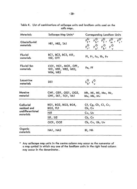
- 38-Table 4 . List of combinations of soilscape units and landform units used on th esoils maps .Materials Soilscape Map Units* Corresponding Landform Unit sGlaciofluvia lmaterialsHR1, HR2, TA1Ff, F h, F 1 , Fm, F rFF GG ~ F Fb,Fluvial BC1, BC2, BC3, KI1 ,materials KI2, OT 1Fluvial fan CO1, HO1, MO1, 011 ,materials WI1, WR1, WR2, WR3 ,WR4, WR5Fl, Ft, Fu, Fb, FvFa, FfLacustri nematerial sDS 1LG vMoraine CM1, OD1, OG1, OG2, Mh, Mi, MI, Mm, Mr,material OH1, SKI, T01, VA1 Mu, Mb, M yColluvial BG1, BG2, BG3, BG4, Cf, Cg, Ch, Ci, Cr ,residual and BG5, FL1 Cb, CvundifferentiatedmaterialsNI1Cv, UvSI1, SI2Cb, Cv001, 002 Cb, Cv, Ub, UvOrganicmaterialsNA1, NA2BI, Nh* Any soilscape map units in the centre column may occur as the numerator ofa map symbol in which any one of the landform units in the right hand colum nmay occur in the denominator .
-39-The topography of each mapping unit, with the exception of Ice, Rock ,Talus, and Recent Moraine was classified according to the guidelines presented i nThe System of Soil Classification for Canada (CSSC 1974) . The topographic classe sas used in this report are presented in Table 5 .Table 5 .Topographic classes used to designate the overall slope within th eareas outlined on the soils maps .Slope CategoriesSymbolSimple Slopes Complex Slope sRange %AC ac O to 5D d 5to 9E e 9to1 5F f 15 to 30G g 30 to 60H h >60<strong>SOIL</strong> PROFILE MORPHOLOGYPedon descriptions and taxonomic classifications were made according tothe criteria established by the System of Soil Classification for Canada (CSSC 1973) .The soil descriptions included thickness and depth of horizons, soil colors (Munsel lColor Notations), texture, structure, consistence, roots, pores, coarse fragments ,horizon boundaries and lime content as well as any other pertinent details . Sitecharacteristics such as slope, aspect, vegetation, and elevation were also noted .
- Page 1 and 2:
t, Agricultur eCanad aSOIL SURVEYof
- Page 3 and 4:
SOIL SURVEY O FYOHO NATIONA LPARK,
- Page 7 and 8: (Contents - cont . . )PageFIGURES1
- Page 10 and 11: (Contents - cont . . . )TABLES (con
- Page 12 and 13: (Contents - cant . . . )TABLES (con
- Page 15 and 16: Gleysolic and Organic soils occur i
- Page 17 and 18: PREFAC EThe soil survey of Yoho Nat
- Page 19 and 20: How to use this repor tThis report
- Page 21 and 22: PARTIGENERAL DESCRIPTION OF THE ARE
- Page 23 and 24: -3-The Kicking Horse River and Kick
- Page 25 and 26: -5-serves hikers in the Lake O'Hara
- Page 27 and 28: -7-mainly in the Cataract Brook - L
- Page 29 and 30: figure 3 . A cirque; typical of man
- Page 31 and 32: -11-Glacial processes are not howev
- Page 33 and 34: -13-Figure 6 . Drainage systems of
- Page 35 and 36: -15-_.iure 7 . Gentle gradients in
- Page 37 and 38: -17-The effect of altitude on clima
- Page 39 and 40: GOLDE NPR ECIP nTAT IO NRAIN + SNO
- Page 41 and 42: Table 2 . Comparison .' of mean mon
- Page 43 and 44: -23-VEGETATIO NGeneral Vegetation P
- Page 45 and 46: -25-The interaction of these soil-f
- Page 47 and 48: -27-profile development is frequent
- Page 49 and 50: -29-PART I IMETHODOLOGYMAPPINGA goo
- Page 51 and 52: Figure 13 . Oblique photo showing t
- Page 53 and 54: Figure 15 . Oblique photo showing t
- Page 55 and 56: -35-~ ♦ YOHO NATIONAL PAR K[D]Ami
- Page 57: -37-Table 3 . An outline of the loc
- Page 61 and 62: -41 -must be treated as an independ
- Page 63 and 64: -43-FIELD TEST S1 . Bulk Density; b
- Page 65 and 66: -45-are calcareous, stratified, med
- Page 67 and 68: -47-Organic Landform sNorco (NA) is
- Page 69 and 70: -51 -LEGENDParent material.colluviu
- Page 71 and 72: -53-Table 7 . Key criteria differen
- Page 73 and 74: -55-BC2 Map Unit (Orthic and Rego G
- Page 75 and 76: -57-Table 10 . Brief description of
- Page 77 and 78: ure 24 . This photo shows the huge
- Page 79 and 80: igure 26 . Site of the pedon chosen
- Page 81 and 82: -63-Figure 28 . Site of the pedon c
- Page 83 and 84: - 65-CLI.Figui 30 . Site of the ped
- Page 85 and 86: -67-Table 15 . Brief description of
- Page 87 and 88: L-69-r_ -, _ 1 4Figure 35 . Site of
- Page 89 and 90: Figure 37 . Site of the pedon chose
- Page 91 and 92: -73-Landform and Parent Material sT
- Page 93 and 94: -75-The silty surface texture, slow
- Page 95 and 96: -77-material and/or shallowness (of
- Page 97 and 98: Figure 44 . Site of the pedon chose
- Page 99 and 100: -81-HR1 Map Unit (Degraded Eutric B
- Page 101 and 102: -83-in the solum, but may exceed 50
- Page 103 and 104: -85-KI - Kicking Horse Soilscape Gr
- Page 105 and 106: -87-Silty surficial textures provid
- Page 107 and 108: -89-Wetness, texture, and potential
- Page 109 and 110:
-91 -Table 27 . Brief description o
- Page 111 and 112:
Site of the pedon chosen to charact
- Page 113 and 114:
-95-Table 29 . Brief description of
- Page 115 and 116:
-97-NI1 Map Unit (Lithic Orthic Eut
- Page 117 and 118:
-99-Figure 62 . Site of the pedon c
- Page 119 and 120:
-101 -EnvironmentThe Ogden soilscap
- Page 121 and 122:
-103-Table 33 . Brief description o
- Page 123 and 124:
-105-Table 34 . Brief description o
- Page 125 and 126:
-107-Figure 70 . Site of the pedon
- Page 127 and 128:
Figure 73 . Degraded Eutric Bruniso
- Page 129 and 130:
_ • _- - ~ . -. n- C . 1 - r IFig
- Page 131 and 132:
-113-YpiFigure 76, Site of the pedo
- Page 133 and 134:
-115-Figure 78 . Site of the pedon
- Page 135 and 136:
-117-OP 1 Map Unit (Cumilic Regosol
- Page 137 and 138:
-119-OT - Otterhead Soi Iscape Grou
- Page 139 and 140:
ure 82 . Site of the pedon chosen t
- Page 141 and 142:
-123-Table 44 . Key criteria differ
- Page 143 and 144:
-125-SI2 Map Unit (Lithic Humo - Fe
- Page 145 and 146:
-127-Landform and Parent Material s
- Page 147 and 148:
-129-Table 47 . Brief description o
- Page 149 and 150:
Figure 91 . Site of the pedon chose
- Page 151 and 152:
-133-Environmen tzones .The Tocher
- Page 153 and 154:
-135--The steep slopes and the rela
- Page 155 and 156:
-137-Table 50 . Brief description o
- Page 157 and 158:
Figure 97 .Site of the pedon chosen
- Page 159 and 160:
-141 -EnvironmentThe Watchtower soi
- Page 161 and 162:
-143-Table 53 . Brief description o
- Page 163:
-145-The stoniness and periodic sno
- Page 166 and 167:
Brief description of the pedon chos
- Page 168 and 169:
-150-late snowmelt areas or streams
- Page 170 and 171:
-152-The soils have been rated acco
- Page 172 and 173:
-154-Table 58 . Guides for assessin
- Page 174 and 175:
-156-Table 60. Guides for assessing
- Page 176 and 177:
-158-Table 62. Guides for assessing
- Page 178 and 179:
-160-Table 64 . Guides for assessin
- Page 180 and 181:
-162-Table 66 . Frost design soil c
- Page 182 and 183:
Table 67r Interpretations for selec
- Page 184 and 185:
(cont . )Table 67: Interpretations
- Page 186 and 187:
-168-(cont . )Table 67 : Interpreta
- Page 188 and 189:
-170-GLOSSARY'AASHO classification
- Page 190 and 191:
-172-Clay films (skins) - Oriented
- Page 192 and 193:
-174-Field capacity - The percentag
- Page 194 and 195:
-176-Humification - The process by
- Page 196 and 197:
-178-Mechanical analyses - See part
- Page 198 and 199:
- :180-Permeability, soil - The eas
- Page 200 and 201:
-182-Slump - A landslide characteri
- Page 202 and 203:
-184-organic carbon, or both .BC -R
- Page 204 and 205:
-186-Granular - More or less rounde
- Page 206 and 207:
-188-Unified Soil Classification Sy
- Page 208 and 209:
-190-Bei I, C .E . 1966 . An ecolog
- Page 210 and 211:
-192-Hutchinson, D . E . 1976. Reso
- Page 212 and 213:
-194-Soil Research and Plant Resear
- Page 214 and 215:
-196--Appendix A :Selected chanical
- Page 216 and 217:
Appendix BtEngineering test data fo
- Page 218 and 219:
Appendix B : Engineering test data
- Page 220 and 221:
Appendix B : Engineering test data
- Page 222 and 223:
-204-Appendix D :Common names and t
- Page 224 and 225:
-206-HERBS (cont )Common Name sCow
- Page 226:
-208-MOSSE SCommon Name sCladina mi