SOIL SURVEY
SOIL SURVEY SOIL SURVEY
-96-■Figure 59 . Site of the pedon chosen to characterize the NI 1 map unit .Figure 60 . Lithic Orthic Eutric Brunisol soil chosen to characteriz ethe N11 map unit . The shallow soil profile over bedroc kand removal of carbonate in the solum are typical of thi smap unit .
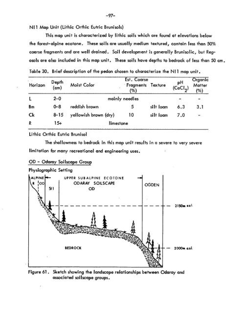
-97-NI1 Map Unit (Lithic Orthic Eutric Brunisols )This map unit is characterized by lithic soils which are found at elevations belo wthe forest-alpine ecotone . These soils are usually medium textured, contain less than 50 %coarse fragments and are well drained . Soil development is generally Brunisolic, but Regosolsare also included in this map unit . These soils have depths to bedrock of less than 50 cm .Table 30 . Brief description of the pedon chosen to characterize the NI 1 map unit .HorizonDepth(cm)Moist ColorEst . Coars eFragments Textur e(%)pH(CaCI 2)L 2-0 mainly needles - -Organi cMatte r(%)Bm 0-8 reddish brown 5 silt loam 6 .3 3 . 1Ck 8-15 yellowish brown (dry) 10 silt loam 7 .0 -R 15+ limeston eLithic Orthic Eutric Bruniso lThe shallowness to bedrock in this map unit results in a severe to very sever elimitation for many recreational and engineering uses .OD - Odaray Soilscape GroupPhysiographic Setting- 2150m a.s .l2000m as.l •Figure 61 . Sketch showing the landscape relationships between Odaray an dassociated soilscape groups .`4•
- Page 63 and 64: -43-FIELD TEST S1 . Bulk Density; b
- Page 65 and 66: -45-are calcareous, stratified, med
- Page 67 and 68: -47-Organic Landform sNorco (NA) is
- Page 69 and 70: -51 -LEGENDParent material.colluviu
- Page 71 and 72: -53-Table 7 . Key criteria differen
- Page 73 and 74: -55-BC2 Map Unit (Orthic and Rego G
- Page 75 and 76: -57-Table 10 . Brief description of
- Page 77 and 78: ure 24 . This photo shows the huge
- Page 79 and 80: igure 26 . Site of the pedon chosen
- Page 81 and 82: -63-Figure 28 . Site of the pedon c
- Page 83 and 84: - 65-CLI.Figui 30 . Site of the ped
- Page 85 and 86: -67-Table 15 . Brief description of
- Page 87 and 88: L-69-r_ -, _ 1 4Figure 35 . Site of
- Page 89 and 90: Figure 37 . Site of the pedon chose
- Page 91 and 92: -73-Landform and Parent Material sT
- Page 93 and 94: -75-The silty surface texture, slow
- Page 95 and 96: -77-material and/or shallowness (of
- Page 97 and 98: Figure 44 . Site of the pedon chose
- Page 99 and 100: -81-HR1 Map Unit (Degraded Eutric B
- Page 101 and 102: -83-in the solum, but may exceed 50
- Page 103 and 104: -85-KI - Kicking Horse Soilscape Gr
- Page 105 and 106: -87-Silty surficial textures provid
- Page 107 and 108: -89-Wetness, texture, and potential
- Page 109 and 110: -91 -Table 27 . Brief description o
- Page 111 and 112: Site of the pedon chosen to charact
- Page 113: -95-Table 29 . Brief description of
- Page 117 and 118: -99-Figure 62 . Site of the pedon c
- Page 119 and 120: -101 -EnvironmentThe Ogden soilscap
- Page 121 and 122: -103-Table 33 . Brief description o
- Page 123 and 124: -105-Table 34 . Brief description o
- Page 125 and 126: -107-Figure 70 . Site of the pedon
- Page 127 and 128: Figure 73 . Degraded Eutric Bruniso
- Page 129 and 130: _ • _- - ~ . -. n- C . 1 - r IFig
- Page 131 and 132: -113-YpiFigure 76, Site of the pedo
- Page 133 and 134: -115-Figure 78 . Site of the pedon
- Page 135 and 136: -117-OP 1 Map Unit (Cumilic Regosol
- Page 137 and 138: -119-OT - Otterhead Soi Iscape Grou
- Page 139 and 140: ure 82 . Site of the pedon chosen t
- Page 141 and 142: -123-Table 44 . Key criteria differ
- Page 143 and 144: -125-SI2 Map Unit (Lithic Humo - Fe
- Page 145 and 146: -127-Landform and Parent Material s
- Page 147 and 148: -129-Table 47 . Brief description o
- Page 149 and 150: Figure 91 . Site of the pedon chose
- Page 151 and 152: -133-Environmen tzones .The Tocher
- Page 153 and 154: -135--The steep slopes and the rela
- Page 155 and 156: -137-Table 50 . Brief description o
- Page 157 and 158: Figure 97 .Site of the pedon chosen
- Page 159 and 160: -141 -EnvironmentThe Watchtower soi
- Page 161 and 162: -143-Table 53 . Brief description o
- Page 163: -145-The stoniness and periodic sno
-97-NI1 Map Unit (Lithic Orthic Eutric Brunisols )This map unit is characterized by lithic soils which are found at elevations belo wthe forest-alpine ecotone . These soils are usually medium textured, contain less than 50 %coarse fragments and are well drained . Soil development is generally Brunisolic, but Regosolsare also included in this map unit . These soils have depths to bedrock of less than 50 cm .Table 30 . Brief description of the pedon chosen to characterize the NI 1 map unit .HorizonDepth(cm)Moist ColorEst . Coars eFragments Textur e(%)pH(CaCI 2)L 2-0 mainly needles - -Organi cMatte r(%)Bm 0-8 reddish brown 5 silt loam 6 .3 3 . 1Ck 8-15 yellowish brown (dry) 10 silt loam 7 .0 -R 15+ limeston eLithic Orthic Eutric Bruniso lThe shallowness to bedrock in this map unit results in a severe to very sever elimitation for many recreational and engineering uses .OD - Odaray Soilscape GroupPhysiographic Setting- 2150m a.s .l2000m as.l •Figure 61 . Sketch showing the landscape relationships between Odaray an dassociated soilscape groups .`4•


