41 questions - Earth Science Regents Review
41 questions - Earth Science Regents Review
41 questions - Earth Science Regents Review
- No tags were found...

You also want an ePaper? Increase the reach of your titles
YUMPU automatically turns print PDFs into web optimized ePapers that Google loves.
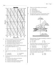
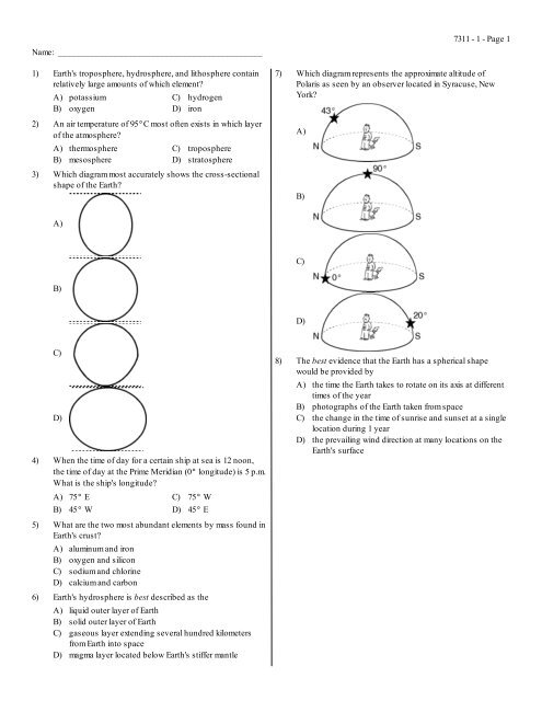
Name: ____________________________________________1) <strong>Earth</strong>'s troposphere, hydrosphere, and lithosphere containrelatively large amounts of which element?A) potassiumB) oxygenC) hydrogenD) iron2) An air temperature of 95DC most often exists in which layerof the atmosphere?A) thermosphereB) mesosphereC) troposphereD) stratosphere3) Which diagram most accurately shows the cross-sectionalshape of the <strong>Earth</strong>?7) Which diagram represents the approximate altitude ofPolaris as seen by an observer located in Syracuse, NewYork?A)B)7311 - 1 - Page 1A)C)B)D)C)D)4) When the time of day for a certain ship at sea is 12 noon,the time of day at the Prime Meridian (0D longitude) is 5 p.m.What is the ship's longitude?A) 75D EC) 75D WB) 45D WD) 45D E8) The best evidence that the <strong>Earth</strong> has a spherical shapewould be provided byA) the time the <strong>Earth</strong> takes to rotate on its axis at differenttimes of the yearB) photographs of the <strong>Earth</strong> taken from spaceC) the change in the time of sunrise and sunset at a singlelocation during 1 yearD) the prevailing wind direction at many locations on the<strong>Earth</strong>'s surface5) What are the two most abundant elements by mass found in<strong>Earth</strong>'s crust?A) aluminum and ironB) oxygen and siliconC) sodium and chlorineD) calcium and carbon6) <strong>Earth</strong>'s hydrosphere is best described as theA) liquid outer layer of <strong>Earth</strong>B) solid outer layer of <strong>Earth</strong>C) gaseous layer extending several hundred kilometersfrom <strong>Earth</strong> into spaceD) magma layer located below <strong>Earth</strong>'s stiffer mantle
9) The diagram below illustrates Eratosthenes' method offinding the circumference of a planet. At noon, when avertical stick at the Equator casts no shadow, a vertical stick2,500 kilometers away casts a shadow and makes an angle of40D with the rays of the Sun as shown.7311 - 1 - Page 210) Which graph correctly represents the three most abundantelements, by mass, in <strong>Earth</strong>'s crust?A)B)What is the circumference of this planet?A) 20,000 kmB) 45,000 kmC) 2,500 kmD) 22,500 kmC)D)
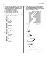
11) The diagram below illustrates Eratosthenes' method offinding the circumference of a planet. At noon, when avertical stick at the Equator casts no shadow, a vertical stick1,000 kilometers away casts a shadow and makes an angle of40D with the rays of the Sun as shown.14) How are latitude and longitude lines drawn on a globe of the<strong>Earth</strong>?A) Longitude lines are parallel and latitude lines meet atthe Equator.B) Latitude lines are parallel and longitude lines meet atthe Equator.C) Latitude lines are parallel and longitude lines meet atthe poles.D) Longitude lines are parallel and latitude lines meet atthe poles.15) Ozone is concentrated in <strong>Earth</strong>'s atmosphere at an altitudeof 20 to 35 kilometers. Which atmospheric layer contains thegreatest concentration of ozone?A) thermosphereB) mesosphereQuestions 16 and 17 refer to the following:C) troposphereD) stratosphere7311 - 1 - Page 3What is the circumference of this planet?A) 40,000 kmB) 12,000 kmC) 9,000 kmD) 4,000 km12) The diagram below represents part of <strong>Earth</strong>'s latitudelongitudesystem.The field map below shows air temperature at specific locations inan area near a school in New York State. Part of this area is ablacktop parking lot. Accurate temperature readings were taken by<strong>Earth</strong> <strong>Science</strong> students at 10 a.m. on June 1. Two reference points,A and B, are shown.What is the latitude and longitude of point L?A) 5D N, 30D EC) 5D S, 30D WB) 5D W, 30D SD) 5D E, 30D N13) At which location will the highest altitude of the star Polarisbe observed?A) EquatorB) Arctic CircleC) central United StatesD) Tropic of Cancer16) On the given field map, draw only the 15DC and the 20DCisotherms. [Isotherms must be extended to the edge of themap.]
17) Calculate the temperature gradient along a straight linebetween point A and point B on the given map by followingthe directions below.(a)(b)(c)Write the equation for determining the temperaturegradient.Substitute the correct values into the equation.Solve the equation and record your answer in decimalform. [Label the answer with the correct units.]18) Which two observers would be experiencing the sameapparent solar time?A) B and CB) A and CC) D and ED) B and E7311 - 1 - Page <strong>41</strong>9) What is the altitude of Polaris (the North Star) above thenorthern horizon for observer A?A) 0DC) 80DB) 90DD) 10DQuestions 18 and 19 refer to the following:The map below shows the latitude and longitude of fiveobservers, A, B, C, D, and E, on <strong>Earth</strong>.Questions 20 and 21 refer to the following:The temperature field map below shows temperature readings (DC) recorded by students in a science classroom. The readings weretaken at the same time at floor level. Temperature readings for points A and B are labeled on the map.
20) On the given temperature field map, use solid lines to drawthe 18DC, 20DC, and 22DC isotherms. [Isotherms mustextend to the boundary of the map. Label each isotherm toindicate its temperature.]7311 - 1 - Page 521) State the temperature (in degrees Fahrenheit [DF]) of point Ain the given map.Questions 22 and 23 refer to the following:On the topographic map of an island shown below, elevations are expressed in feet. Points A, B, C, and D are locations on the island. Atriangulation point shows the highest elevation on the island.22) On the grid below, construct a topographic profile representing the cross-sectional view between point A and point B, followingthe directions below.(a)(b)Plot the elevation of the land along line AB by marking, with a dot, the elevation of each point where a contour line iscrossed by line AB.Connect the dots with a smooth, curved line to complete the topographic profile.23) What is the average gradient, in feet per mile, along the straight line from point C to point D?
24) The map below shows a portion of a drumlin field near Palmyra, New York. Elevations are in feet.7311 - 1 - Page 6What is the contour interval of the given map?A) 25 ft B) 10 ft C) 20 ft D) 5 ftQuestions 25 through 28 refer to the following:On the topographic map below, points A, B, Y, and Z are reference points on the topographic map. The symbolhighest elevation on Aurora Hill.533 represents the25) Describe the evidence shown on the map that indicates thatthe southern side of Holland Hill has the steepest slope.
26) On the grid below, construct a topographic profile frompoint A to point B by following the directions below.7311 - 1 - Page 727) State the general compass direction in which Maple Streamis flowing.(a)(b)Plot the elevation along line AB by marking with an Xeach point where a contour line is crossed by line AB.[Points A and B have been plotted for you.]Complete the profile by correctly connecting theplotted points with a smooth, curved line.28) Calculate the gradient between points Y and Z on the map.[Label the answer with the correct units.]Questions 29 through 31 refer to the following:Points A through D are locations on the topographic map below. Elevations are in feet.
29) On the grid below, construct a profile of the land surfacebetween point C and point D by following the directionsbelow.(a)(b)Plot the elevations along line CD by marking with a doteach point where an isoline is crossed by line CD.Connect the dots to complete the profile.7311 - 1 - Page 830) Determine the gradient from point A to point B by followingthe directions below.(a)(b)(c)Write the equation for determining the gradient.Substitute data from the map into the equation.Calculate the gradient and label it with the proper units.31) Explain briefly how the map can be used to determine thatJones Creek is flowing westward into Jones Lake.
Questions 32 and 33 refer to the following:7311 - 1 - Page 9The topographic map below is of an area in New York State. Points X and Y are locations on Squab Hollow Creek.32) Describe one way to determine the direction of flow ofCoover Hollow Creek from information shown on the map.33) In the space below, determine the gradient of Squab HollowCreek between point X and point Y by following thedirections below.(a)(b)(c)Using the <strong>Earth</strong> <strong>Science</strong> Reference Tables, write theequation used to determine the gradient.Substitute values into the equation.Solve the equation and label the answer with thecorrect units.
Questions 34 through 36 refer to the following:7311 - 1 - Page 10Points X, Y, and Z are locations on the topographic map below. Elevations are expressed in meters.34) Mill River generally flows toward theA) southwestB) southeastC) northeastD) northwest35) Which profile best represents the topography along thedashed line from point X to point Y?36) What is the elevation of point Z?A) 240 mB) 220 mC) 190 mD) 250 mA)B)C)D)
7311 - 1 - Page 1137) The temperature field map below represents surface air temperatures within a park. The location of a lake within the park is alsoindicated.Which graph best represents the temperature profile along a straight line from point A to point B?A)C)B)D)
Questions 38 through <strong>41</strong> refer to the following:7311 - 1 - Page 12A group of <strong>Earth</strong> <strong>Science</strong> students decided to take an adventurous camping trip, so they rode bicycles to a New York State park thatwas located in an isolated area. They traveled up a steep hill. When they reached the top, they looked at the landscape and noticed alake at the bottom of the hill. They named it Hidden Lake. To the left of Hidden Lake was a large field with a small stream. They decidedto set up their campsite in the field near Hidden Lake. To get to the field, they cycled down a very steep slope.The map below shows the location of the bicycle trail and the students' campsite. Points P and Q are reference points on the map.38) (a) The next day the students decided to move theircampsite 1 mile directly east of their original campsite.On the given map, place another campsite symbol, ,to indicate the location of their second campsite.(b) The students decided to take a different route home toavoid riding their bicycles up the steep hill. Plan areturn route that will take the campers back to point Pand that will involve the least change in elevationduring the trip. On the given map, draw a line from thesecond campsite to point P to show the route. Placearrows on the line to show the direction that thestudents will be traveling.40) On the grid below, draw a profile of the landscape along thebicycle trail from point P to point Q by following thedirections below.39) (a) State the general compass direction in which thestream is flowing in the given map.(b) State how contour lines provide the evidence fordetermining this direction.(a)(b)Plot the elevation along line PQ by marking with a doteach point where a contour line is crossed by line PQ.Point P and point Q have been plotted for you.Connect the dots to complete the profile.<strong>41</strong>) State the evidence shown on the given map that indicatesthat the area directly north of Hidden Lake is relatively flat.