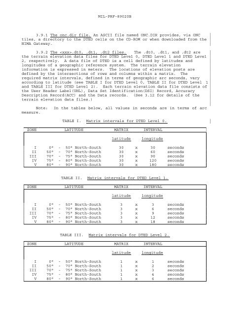
MIL-PRF-89020B3.9.1 The onc.dir file. An ASCII file named ONC.DIR provides, via ONCtiles, a directory to the DTED cells on the CD-ROM or when downloaded from theNIMA Gateway.3.9.2 The .dt0, .dt1, .dt2 files. The .dt0, .dt1, and .dt2 arethe <strong>terrain</strong> <strong>elevation</strong> <strong>data</strong> files for DTED Level 0, DTED Level 1 and DTED Level2, respectively. A <strong>data</strong> file of DTED is a cell defined by latitudes andlongitudes of a geographic reference system. The <strong>terrain</strong> <strong>elevation</strong>information is expressed in meters. The locations of <strong>elevation</strong> posts aredefined by the intersections of rows and columns within a matrix. Therequired matrix intervals, defined in terms of geographic arc seconds, varyaccording to latitude (see TABLE I for DTED Level 0, TABLE II for DTED Level 1and TABLE III for DTED Level 2). Each <strong>terrain</strong> <strong>elevation</strong> <strong>data</strong> file consists ofthe User Header Label(UHL), Data Set Identification(DSI) Record, AccuracyDescription Record(ACC) and the Data records. (See 3.12 for details of the<strong>terrain</strong> <strong>elevation</strong> <strong>data</strong> files.)Note: In the tables below, all values in seconds are in terms of arcmeasure.TABLE I. Matrix intervals for DTED Level 0.ZONE LATITUDE MATRIX INTERVALlatitudelongitudeI 0° - 50° North-South 30 x 30 secondsII 50° - 70° North-South 30 x 60 secondsIII 70° - 75° North-South 30 x 90 secondsIV 75° - 80° North-South 30 x 120 secondsV 80° - 90° North-South 30 x 180 secondsTABLE II. Matrix intervals for DTED Level 1.ZONE LATITUDE MATRIX INTERVALlatitudelongitudeI 0° - 50° North-South 3 x 3 secondsII 50° - 70° North-South 3 x 6 secondsIII 70° - 75° North-South 3 x 9 secondsIV 75° - 80° North-South 3 x 12 secondsV 80° - 90° North-South 3 x 18 secondsTABLE III. Matrix intervals for DTED Level 2.ZONE LATITUDE MATRIX INTERVALlatitudelongitudeI 0° - 50° North-South 1 x 1 secondsII 50° - 70° North-South 1 x 2 secondsIII 70° - 75° North-South 1 x 3 secondsIV 75° - 80° North-South 1 x 4 secondsV 80° - 90° North-South 1 x 6 seconds
MIL-PRF-89020B3.9.3 The .avg, .min, .max files. The .avg, .min and .max <strong>data</strong>files are unique to DTED Level 0. They contain the average, minimum andmaximum <strong>terrain</strong> <strong>elevation</strong> value associated with each DTED Level 0 <strong>elevation</strong>value. The average, minimum and maximum values are calculated from DTEDLevel 1. Each 30" x 30" area of DTED1 (11 posts x 11 posts) are searched forthe minimum and maximum value; while the average is calculated from the 121values. Notice therefore that the row and columns of posts that divide each30"x 30" area are included in the calculations for two of the values. The.avg, .min, and .max files are composed of a Motorola (i.e., SUN) Format two(2) byte integer structure. Each <strong>data</strong> file consists of the User HeaderLabel(UHL), Data Set Identification(DSI) Record, Accuracy DescriptionRecord(ACC) and the Data records. The .avg, .min, and .max files arereferenced by the subcell's center coordinate pair. A subcell of DTED Level 0is defined as equal to thirty (30") arc second by thirty (30") arc second.The latitude spacing will always be consistent based upon the DTED level ofthe <strong>data</strong>, whereas the longitude spacing is dependent upon the level of the<strong>data</strong> and geographic zone (See Table I). This file shall not cross wholedegree latitude and longitude lines.3.9.4 The Read.me file. An ASCII text file named Read.me contains adescription of the disc contents including the geographic limits of thecompact disc, a count of the cells, a location diagram (text array) showingwhich cells in the minimum bounding rectangle are resident on the disc, and auser’s guide.3.9.5 The DMED. file. The Digital Mean Elevation Data (DMED) file is anASCII text file. It contains, for each 15' x 15' area of a 1°x1° cell, theminimum and maximum <strong>elevation</strong>, the mean <strong>elevation</strong>, and the standard deviation.The DMED file is a series of 394-byte records. The first record is a headergiving the extremes of the minimum bounding rectangle (MBR) (in degrees)encompassing the cells on the CD. For example, the value: N30N36E020E032followed by 380 spaces indicates that the MBR is 6° high and 12° wide. Thenext record has the <strong>data</strong> for the extreme southwest 1° cell in the MBR. Thethird record is for the 1° cell above that, and so forth, to the top of theMBR. Moving eastwardly, and until the edge of the MBR is reached, the nextcolumn of 1°x1° cells is added to the file with placement being from south tonorth. If a cell in the MBR is not included on the CD, its DMED recordconsists of its coordinates followed by 387 spaces (ASCII blanks).3.9.5.1 Individual cell record. An individual cell record containsthe geographic coordinates of the cell’s southwest corner, the <strong>data</strong> editionnumber, the match/merge version of the cell from which the DMED is calculatedand the following information about each 15' x 15' area of the cell: theminimum and maximum <strong>elevation</strong>s, the mean <strong>elevation</strong>, and the standard deviationof the <strong>elevation</strong>s. Data are all upper-case ASCII characters. Elevationvalues are to the nearest meter. In a 1° cell, the <strong>elevation</strong>s in the threerows and three columns, which divide the 15' x 15' areas from each other, arecounted in two areas. The order in which the 16 areas of a cell follow theheader is:4 8 12 163 7 11 152 6 10 141 5 9 13Field Field Length CharacterContents in Characters Start Description9