performance specification digital terrain elevation data
performance specification digital terrain elevation data
performance specification digital terrain elevation data

Create successful ePaper yourself
Turn your PDF publications into a flip-book with our unique Google optimized e-Paper software.
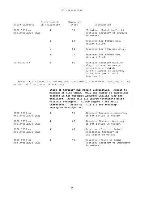
MIL-PRF-89020BField Length CharacterField Contents In Characters Start Description0000-9999 or 4 16 *Relative (Point-to-Point)Not Available (NA)Vertical Accuracy of Productin meters.4 20 Reserved for future use.(Blank filled.)1 24 Reserved for NIMA use only.31 25 Reserved for future use.(Blank filled.)00 or 02-09 2 56 Multiple Accuracy OutlineFlag. 00 = No accuracysubregions provided.02-09 = Number of accuracysubregions per 1° cell(maximum 9).Note: *If Product has subregional accuracies, the overall accuracy of theproduct will be the worst accuracy.Start of Accuracy Sub region Description. Repeat tomaximum of nine times. Only the number of subregionsdefined in the Multiple Accuracy Outline Flag arepopulated. Blank fill all unused coordinate pairswithin a subregion. (1 Sub region = 284 ASCIICharacters). Refer to 3.13.5.1 for accuracysubregion description.0000-9999 or 4 58 Absolute Horizontal AccuracyNot Available (NA)of Sub region in meters0000-9999 or 4 62 Absolute Vertical AccuracyNot Available (NA)of Sub region in meters.0000-9999 or 4 66 Relative (Point-to-Point)Not Available (NA)Horizontal Accuracy ofSub region in meters.0000-9999 or 4 70 Relative (Point-to-Point)Not Available (NA)Vertical Accuracy of Subregionin meters.28