Umrer Coalfield - Western Coalfields Limited
Umrer Coalfield - Western Coalfields Limited
Umrer Coalfield - Western Coalfields Limited

You also want an ePaper? Increase the reach of your titles
YUMPU automatically turns print PDFs into web optimized ePapers that Google loves.
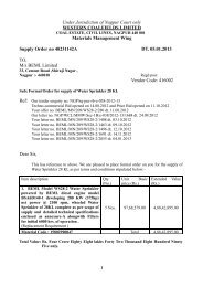
CMPDITable 3.2Land use/ cover pattern in <strong>Umrer</strong> <strong>Coalfield</strong> for the year 2011(Based on IRS-P6-LISS-III Data)Sl.Jan-11No.Land Use / Cover ClassesIRS – P6 / LISS – III DataLevel - I Level - II Km 2 %Settlement Rural 1.34 1.21Urban 0.73 0.66Industrial 0.25 0.23123456VegetationCoverMining AreaAgriculturalLandWaste LandWater BodySub-Total 2.33 2.10Open Forest 1.33 1.20Scrubs 13.57 12.26Social Forestry 0.45 0.41Plantation on OB 0.10 0.09Plantation on Backfill 0.84 0.76Sub – Total 16.29 14.71Coal Quarry 1.50 1.36Advanced Quarry Site 0.06 0.06Barren OB Dump 0.38 0.34Barren Backfill 2.77 2.50Coal Dump 0.21 0.19Water filled Quarry 0.11 0.10Sub – Total 5.04 4.55Crop Land 24.96 22.54Fallow Land 46.83 42.30Sub – Total 71.79 64.84Waste land with / withoutScrubs 8.30 7.50River, nallah, pond etc.6.97 6.29TOTAL 110.72 100.00RSC-561410027(WCL) [ Page 27 of 32 ]
![To [Name & Address of the Assured] Dear Mr./Ms.[______] Subject ...](https://img.yumpu.com/48378713/1/190x245/to-name-address-of-the-assured-dear-mr-ms-subject-.jpg?quality=85)