Umrer Coalfield - Western Coalfields Limited
Umrer Coalfield - Western Coalfields Limited
Umrer Coalfield - Western Coalfields Limited

You also want an ePaper? Increase the reach of your titles
YUMPU automatically turns print PDFs into web optimized ePapers that Google loves.
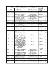
CMPDIcharacteristics, settlement and transport network, etc., and their monitoring innear real - time is very useful for environmental management planning; this ispossible only with remote sensing data.2.4 Data SourceThe following data are used in the present study:• Primary DataRemote Sensing Satellite data viz. Resourcesat-IRS-P6/LISS-III of 2011having 23.5 m. spatial resolution was used in the present study. The rawdigital satellite data was obtained from NRSC, Hyderabad, on CD-ROMmedia.• Secondary DataSecondary (ancillary) and ground data constitute important baselineinformation in remote sensing, as they improve the interpretation accuracyand reliability of remotely sensed data by enabling verification of theinterpreted details and by supplementing it with the information that cannot beobtained directly from the remotely sensed data. For <strong>Umrer</strong> <strong>Coalfield</strong>, Surveyof India topo sheet no. 55 P/1 and 55 P/5 on RF 1:50000 as well as mapshowing details of location of area boundary, block boundary and roadsupplied by WCL were used in the study.2.5 Characteristics of Satellite/SensorThe basic properties of a satellite’s sensor system can be summarised as:(a) Spectral coverage/resolution, i.e., band locations/width; (b) spectraldimensionality: number of bands; (c) radiometric resolution: quantisation;(d) spatial resolution/instantaneous field of view or IFOV; and (e)RSC-561410027(WCL) [ Page 13 of 32]
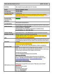
![To [Name & Address of the Assured] Dear Mr./Ms.[______] Subject ...](https://img.yumpu.com/48378713/1/190x245/to-name-address-of-the-assured-dear-mr-ms-subject-.jpg?quality=85)