Briefing Kit4.pdf - Hinze Dam Stage 3
Briefing Kit4.pdf - Hinze Dam Stage 3
Briefing Kit4.pdf - Hinze Dam Stage 3
- No tags were found...

You also want an ePaper? Increase the reach of your titles
YUMPU automatically turns print PDFs into web optimized ePapers that Google loves.
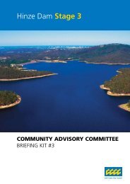
<strong>Hinze</strong> <strong>Dam</strong> <strong>Stage</strong> 3COMMUNITY ADVISORY COMMITTEE<strong>Briefing</strong> Kit #4
<strong>Hinze</strong> <strong>Dam</strong> <strong>Stage</strong> 3Contents1.0 Purpose 12.0 Project Update 12.1 Where to From Here? 12.2 Ongoing Technical Assessments 12.3 Map 3Appendix AAppendix B
<strong>Hinze</strong> <strong>Dam</strong> <strong>Stage</strong> 31.0 PurposeThis briefing kit will provide Community Advisory Committee(CAC) members with further information regarding the<strong>Hinze</strong> <strong>Dam</strong> <strong>Stage</strong> 3 upgrade specifically:<strong>Dam</strong> design short listed optionsCommunity Consultation activitiesRecreation Planning process2.0 Project Update2.1 Where to from here?Concept Design and Target Outturn Cost (TOC) Optimisation (Jan 2007) Concept design ( Jan – Feb 2007) Develop TOC (Jan – April 2007)Early Works ToR (late Jan - March 2007) EIS (Jan – August 2007)Community consultation on the ToR & EIS(Jan – July 2007) Approvals (mid 2007) Early works construction (mid 2007)Works Delivery Final approvals (late 2007) Final detailed design (late 2007) Construction (late 2007 - 2010)Handover from Gold Coast City Council (GCCC) to GoldCoast Water (GCW) for operation (ready to store water2010)2.2 Ongoing Technical Assessments<strong>Dam</strong> DesignThe <strong>Hinze</strong> <strong>Dam</strong> Alliance presented the Community AdvisoryCommittee on Tuesday January 16 2007, with an update onthe design options PS1 and AS9. Part of this design updateinvolved detailed design developments and assessments onboth the PS1 and AS9 options, and a new third option PS1Awhich is a variation of PS1 that has eliminated the needfor fuse gates. Please refer to Appendix A for an outline ofthe three selected design options. On 19 January 2007 theAlliance conducted a workshop to determine the preferreddam design option; this recommended option will bepresented to the Committee on the 30 January 2007.Recreation PlanningThe investigation into use of the dam project area duringthe construction phase and the recreation master planhas been undertaken and preparation of a RecreationContinuance Plan has commenced. During this processthere has been extensive engagement with recreationgroups, the community currently using the dam, communitystakeholders, GCCC staff and Gold Coast Water.Inspections of both the dam and catchment areas haveprovided essential information to the Alliance to enable anunderstanding of the current range of recreation uses.Feedback from the Committee meetings has given abroad direction on existing recreational use around thedam. Detailed concept designs and planning can now bedeveloped, including locations of specific facilities andrecreation access. Initial design ideas and concepts fora proposed interpretive centre and integrated parklandareas will be presented at the next meeting, in additionto discussion of a Recreation Continuance Plan that willoperate whilst construction is underway. Information onissues raised at the previous meeting (rowing, additionalboat ramp location, management of certain recreationactivities) will also be discussed.1
Geotechnical InvestigationsGeotechnical investigations re-commenced on 8 January2007 and are estimated to be completed by the end ofFebruary 2007. Residents and recreational users have beenadvised that as part of the <strong>Hinze</strong> <strong>Dam</strong> <strong>Stage</strong> 3 GeotechnicalStudies the access road across the dam will be closed to alltraffic for three weeks, commencing Saturday 20 January.The road will be re-opened across the Australia Day longweekend, from Friday 26 January until Sunday 28 January.Public Notices have been placed in the Gold Coast Bulletin,Albert and Logan News, and The Sun from Wednesday 17January 2007 to Saturday 27 January 2007. These publicnotices will also extend into February 2007.Signs along the roadside have also been placed on thecorner of Gilston and Worongary Roads, and also on thecorner of Advancetown and Normandy- MurwillumbahRoads, to advise residents and visitors of the road closure.Consultation UpdateThe <strong>Hinze</strong> <strong>Dam</strong> Alliance communication and consultationteam has commenced a number of communicationactivities to provide the community with project updates.Opportunities to offer feedback on the <strong>Hinze</strong> <strong>Dam</strong> <strong>Stage</strong> 3project will occur via:Fact SheetsCommunity Door KnocksInformation SessionsStatutory Library DisplaysInformation LineEmail and Comment FormsMedia RelationsWebsiteThe Alliance is preparing information sessions for the publicto find out more about the concept design and providecomments on the Terms of Reference (ToR). The Alliance isalso preparing the statutory displays for the ToR which willinclude displays in libraries, local venues such as schoolsand divisional offices. Dates are yet to be confirmed but thedisplays are expected to commence mid-February 2007.On 17 January 2007 Chanel 9 and NBN televised a newsitem focussing on the commencement of the geotechnicaldrilling program. CAC Deputy Chair, Cr Daphne McDonaldwas interviewed by both television stations.An editorial on the preferred option currently is also beingprepared for publication. This may generate further mediainterest.A dedicated email is now functional for public comments.All emails will be checked by the communication andconsultation team and escalated to Project Team leaders asrequired.The website is also being rebuilt with more functionality andwill be populated with more project information.A fact sheet describing the progress of the project to datewas sent as part of a mail-out to approximately 5000 peoplein the local and wider community. See Appendix B for acopy of the fact sheet and cover letters to both the local andwider community.The Alliance has also extended an invitation to over 300residents to meet with members of the communication andconsultation team. These meetings will be conducted duringthe door knock week commencing 5 February 2007.2
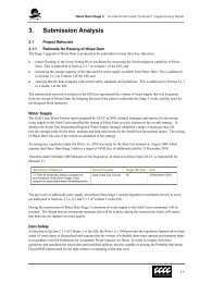
SPILLWAY ROADBEECHMONT ROADLITTLENERANG ROAD<strong>Hinze</strong> <strong>Dam</strong> <strong>Stage</strong> 32.3 MapSAN FERNANDO DRIVEEVANITA DRIVEWORONGARY ROADTHE SPURHUGH GUINEA COURTARTHUR PAYNE COURTHARRY MILLS DRIVEINCLINE DRIVEGLENAURA DRIVEGLENROWAN DRIVECHARLES KURZ DRIVENANCY YAUN COURTRANDOM WAYUPLANDS COURTLEISURE LANEVINCE HINDE DRIVEIMFELD COURTCOORUMBENE COURTXANADU COURTCORALCOAST DRIVETHE PANORAMAFOXTAIL COURTUTOPIA COURTVISCOUNT DRIVEEARLE COURTDUKE COURTDUCHESS COURTVERONICA DRIVEOTIOSE COURTTALLAI ROADRANGE ROADTOLHURST COURTBAILEYS ROADGRANDVIEW TERRACESTRIKE WAYKERALA COURTWALLANDRAROADKAGOOLA DRIVEBERRIGANS ROADRAYNER LANEMARK WAYJULIE WAYPINETREE COURTTARRANT DRIVEGILWARD DRIVEMANUKA ROADROADROADHORSESHOE DRIVETYALGUM STREETWALLABY DRIVEMONARO ROADJOHNS ROADBELMONT PARK DRIVESWANSON PLACELOWRY COURTROADAUSTINVILLE ROADBROMFIELD DRIVECAMP DRIVEDUNBAR ROADARAUCARIA LANEROADKNACK ROADSTAGHORN DRIVEDAVENPORT DRIVERED OAK DRIVEROADHINZE DAMSTAGE 3SITE PLANLegendProperty BoundaryRoadsFull Supply Level±0 425 850 1,700MetersScale - 1:20,000(at A1)Projection: MGA Zone 56ROADTALLAI ROADMOUNT NIMMEL ROADROADGILSTON ROADDUNCAN ROADTOULA COURTADVANCETOWN ROADROADROADNARROWLEAF ROADROADROADNARROWLEAF ROADROADBRUSHBOX ROADNORTH ROADLOOP ROADNERANG MURWILLUMBAH ROADROADCLOSED ROADTA RLINGTON ROADMIRANI STREETJARDINE ROADPOCKET ROADCLOSED ROADELIMBAH COURTROADROADROADROADROADROADROAD3
<strong>Hinze</strong> <strong>Dam</strong> <strong>Stage</strong> 3Appendix A
<strong>Hinze</strong> <strong>Dam</strong> <strong>Stage</strong> 3Summary of Design OptionsThe <strong>Hinze</strong> <strong>Dam</strong> Alliance commenced work on developing a number of dam design options in October 2006. A workshopheld on 6 November 2006 established a broad range of possible options for further consideration. The Alliance undertook anassessment of the spillway options and conducted a workshop on 6 December 2006 where the options were short listed to:Option 1 – PS1- Primary spillway with Fusegates for <strong>Dam</strong> SafetyOption 2 – AS9- Auxiliary spillway with Labyrinth spillway for <strong>Dam</strong> SafetyAs part of design development during late December 2006 and early January 2007, the Alliance identified a variation ofOption PS1 without Fusegates and with a higher dam crest level, designated PS1A.Comparison of AdvantagesThe comparison of the advantages of each design option are summarised in the table below:Comparison of Advantages PS1 PS1A AS9Works confined to main spillway, visual amenity, and recreation space around dam <strong>Dam</strong> Crest at 106.0 (less work to raise dam) Passive spillway for dam safety (no fusing elements) Avoids need for specialist subcontractors Gradual rise of downstream floodwaters in extreme events Minimises upgrade of downstream chute Minimal risk of foundation conditions
PS1 – FusegatesDesign Summary15m wide small spillway for flood mitigationFusegate spillway for extreme floods– 98.8 m long (13 x 7.6m wide Fusegates)– excavate into left bank to provide extra width– Fusegates 5m high – prefabricated in steel & concrete– Fusegates tip over in 10,000 year flood to increasecapacity Full Supply Level 94.5m <strong>Dam</strong> Crest Level 106.0mTraining walls to downstream chute to be raised 4mto accommodate new flows. If the fusegates did blockthe chute it is designed to allow extreme floods to passsafety.Fusegate designed to collapse after tipping, reducing therisk of blockage downstream.
<strong>Hinze</strong> <strong>Dam</strong> <strong>Stage</strong> 3PS1A – No FusegatesDesign SummaryAlternative to option PS1 to simplify design and tominimise riskNo Fusegates– Spillway similar to existing<strong>Dam</strong> crest level of 108.4 m15m wide spillway for flood mitigationUngated spillway for extreme floods55m wideOverflows in 1:200 year flood event Full Supply Level 94.5m
AS9 – Auxiliary SpillwayDesign SummaryPrimary Spillway– 15m wide spillway for flood mitigation– 35m wide high level spillway overflows in 200 yearflood eventAuxiliary Labyrinth Spillway– 8 cycle labyrinth overflows into side channel– Total length 135m and walls 4m high– Overflows in 500 year flood eventLabyrinth extended around side channelReduced depth of side channelWalls reduced from 5m to 4m height Full Supply Level increased to 94.5m– Same as other options
<strong>Hinze</strong> <strong>Dam</strong> <strong>Stage</strong> 3Appendix B
FACT SHEET 2 <strong>Hinze</strong> <strong>Dam</strong> <strong>Stage</strong> 3 (HDS3) UpgradeWorking for our future – todayProject OverviewThe Gold Coast Waterfuture Strategy lists the raising of the <strong>Hinze</strong> <strong>Dam</strong> wall as an important activity required to increasewater storage capacity and provide increased peace of mind for residents and businesses in downstream flood zones.HistoryCompleted in 1976, <strong>Stage</strong> 1 of the <strong>Hinze</strong> <strong>Dam</strong> provided astorage capacity of 42,400 million litres, which was increased to161,070 million litres with the completion of <strong>Stage</strong> 2 in 1989.The initial concept <strong>Stage</strong> 3 upgrade proposed that the damembankment wall be raised from 93.5 metres to 106 metres,providing a total water supply capacity of 286,500 millionlitres – (that’s about 763,000 Olympic sized swimming pools).In September 2006 Gold Coast City Council (GCCC) selecteda consortium of private sector partners to join them in aworking alliance to raise the height of the dam wall.This alliance brings together GCCC with three privatesector partners that are leaders in major waterinfrastructure projects. The <strong>Hinze</strong> <strong>Dam</strong> Alliance comprisesof Thiess, URS and Sinclair Knight Merz (SKM).Thiess holds extensive experience in project and financialmanagement and the construction of major dams;URS specialises in dam design, engineeringand geotechnical skills; and SKM is skilled in gaining approvals,community and stakeholder consultation, andenvironmental and recreational planning.On November 8, 2006 <strong>Hinze</strong> <strong>Dam</strong> <strong>Stage</strong> 3 was declareda “Significant Project” under the State Development andPublic Works Organisation Act (1971). The SignificantProject designation reflects the fact that the project: has a strategic significance to the region; is characterised by complex approval requirements; and meets one or more tests of environmental,economic and / or social significance.The project will require an Environmental ImpactStatement (EIS) under Part 4 of the State Developmentand Public Works Organisation Act (1971).
FACT SHEET 2 <strong>Hinze</strong> <strong>Dam</strong> <strong>Stage</strong> 3 (HDS3) UpgradeKey Objectives of the Upgrade1. Minimise potential floodingIn December 2003 the Nerang River Flood MitigationAdvisory Committee recommended that Council raise the<strong>Hinze</strong> <strong>Dam</strong> wall to help reduce flooding of the Nerang RiverCatchment. Raising the dam wall will delay the releaseof floodwater into the lower reaches of the floodplainby temporarily storing a greater volume of water.The dam raise will incorporate a new spillway (overflowoutlet), designed to reduce the flow of water from thedam following heavy rain. Peak flood levels and damagein the lower catchment will be reduced by minimisingthe rate floodwater is released from the dam.2. Increase water storage and supply capacityThe Gold Coast population is estimated to reach around1.2 million people by 2056. By this time the city willrequire approximately 465 million litres of water per day.This is more than double the volume of water currentlyrequired to meet the Gold Coast’s present needs.Raising the dam wall for additional water storage is akey component of the Gold Coast Waterfuture Strategy(2006-2056); the blueprint for developing a sustainablewater supply for the city over the next 50 years.3. Achieve compliance with all regulatoryguidelinesThe upgraded dam will comply with guidelinesand standards under the Water Act 2000.Community Advisory CommitteeCouncil has established a Community Advisory Committee(CAC) to provide a representative forum that considers aspectsof the HDS3 project that are of interest to the community.Council approved nominated CAC members on the basisof their ability to represent their specific interest group.The role of the Committee is to facilitate effective andappropriate community and stakeholder input intothe HDS3 Project, and to provide recommendations toCouncil on technical and policy issues relating to theproject, as required. Please visit www.goldcoast.qld.gov.au/hinzedamstage3 for more information.Project TimelinePhase 1: 2007Concept Design, Approvals and Target Budget:Optimise – identify the best solution to achievethe objectives of flood mitigation, additional waterstorage capacity and regulatory compliance;Concept Design – develop an initial design for the upgrade;Develop Target Outturn Cost (budget)– estimate the total project cost;Terms of Reference (ToR) for the Environmental ImpactStatement (EIS) – The ToR define the issues that mustbe addressed in the EIS. The final ToR are determinedby the Department of Infrastructure QueenslandGovernment after a formal public consultation period;EIS – After the ToR have been finalised, a draft EIS is preparedwhich is released for public comment. During the commentperiod, members of the community may make submissionsto the Coordinator General on issues addressed in the draftEIS. After this period the final EIS is then prepared and, ifall the conditions are met, (taking into consideration publicsubmissions), it is then approved by the Coordinator General;Detailed Design - Once the concept design hasbeen approved a detailed design of the damwall and spillway is undertaken. This design isthen submitted to Council for approval;Approvals – The GCCC is subject to the legislationgoverning major infrastructure projects and as such, theGCCC must gain the necessary approvals before the projectcan proceed. This includes an approval of the EIS; andEarly Construction Works – During this periodthe site would be prepared for the raising of thedam wall and building the new spillway.Phase 2: 2008 to 2010Works Delivery:Construction – Assuming the project meets all requirementsconstruction is expected to commence early in 2008with project completion expected during 2010;Handover from Alliance to Gold Coast Water- Once the project has been completed to thesatisfaction of Council, the <strong>Hinze</strong> <strong>Dam</strong> site wouldbe returned to Gold Coast Water to manage.2 Project Overview
FACT SHEET 2 <strong>Hinze</strong> <strong>Dam</strong> <strong>Stage</strong> 3 (HDS3) UpgradeEnvironmental Impact StatementGCCC will undertake an EIS during Phase 1 of theproject. The EIS will address all social, environmentaland economic issues associated with the HDS3 upgradeand must address the ToR approved by the CoordinatorGeneral (Qld Department of Infrastructure).The community is encouraged to comment on the ToR and theEIS as per the timeframes outlined below. Public Notices willbe placed in local and national newspapers inviting membersof the public to make submissions on the ToR and EIS.Phase 1Late January – March 2007Terms of Reference(ToR)How the EIS is undertaken willbe guided by the ToR.The community is encouragedto comment on the ToRbetween late Jan – March2007.For more information pleasevisit:www.goldcoastcity.com.au/hinzedamstage3Phase 2Late May – June 2007Environmental ImpactStatement (EIS)COMMUNITY CONSULATIONCommunity feedback is encouraged toascertain potential impacts, benefits andpossible mitigation strategies for inputinto the final EIS.It is anticipated that the formal EISconsultation period will occur betweenlate May – June 2007.INTEGRATED OPTION DESIGN Hydraulic Modelling Detailed Design (preferred option)ENVIRONMENTAL IMPACT STUDIES Aquatic Ecology Studies <strong>Dam</strong> Survey Cultural Heritage Studies Geotechnical Investigations Infrastructure Survey Recreational Planning Terrestrial Fauna and Flora Traffic StudiesPhase 3Late 2007ApprovalsState and Federal Governmentapprove <strong>Stage</strong> 3 upgradeoption.Project Overview 3
FACT SHEET 2 <strong>Hinze</strong> <strong>Dam</strong> <strong>Stage</strong> 3 (HDS3) UpgradeConstruction PeriodEnvironmentMinimising impacts on the environment are a priority forCouncil in the HDS3 upgrade. All project activities willbe underpinned by Environmental Management Plans inaccordance with State and Federal Government Legislation.Road AccessThe <strong>Hinze</strong> <strong>Dam</strong> is located on Council owned property withaccess gained via Advancetown Road or Gilston Road.During Phase 2 of the project, the area around the damwall will become a construction zone with limited accessto the site via Advancetown Road and/or Gilston Road.Heavy Vehicle TrafficIt is anticipated that much of the material required forconstruction will be extracted from within the <strong>Hinze</strong> <strong>Dam</strong> site.As a result the majority of total truck movement is likely tobe confined to the dam site itself (refer to diagram below).There is likely to be an increase in heavy vehicle trafficalong Advancetown Road and/or Gilston Road in theinitial stages of construction. Increased truck movementmay occur on these roads to deliver off-site constructionmaterial such as cement and fuel. Residents along truckmovement corridors will be contacted prior to construction.Quarrying ActivitiesAll quarrying activities will be confined to the <strong>Hinze</strong> <strong>Dam</strong> site.Residents in the immediate area will be provided with a detailedbriefing prior to such activity (including rock blasting activity).Accessing the <strong>Hinze</strong> <strong>Dam</strong>A number of options are currently being considered as to whatlevel of public access will be permitted during constructiondue to activities such as heavy vehicle movements and heavyblasting. No decision has been made at this point. The safety ofthe public will be a key driver in the decision making process.The GCCC welcomes feedback from the community. Pleasecontact Council if you have any issues or concerns.Contact informationTelephone: 1300 366 692Email: hds3@goldcoast.qld.gov.auIndicative map only. Subject to change.HDFS_02