

download pdf - Utah Geological Survey - Utah.gov
download pdf - Utah Geological Survey - Utah.gov
download pdf - Utah Geological Survey - Utah.gov

You also want an ePaper? Increase the reach of your titles
YUMPU automatically turns print PDFs into web optimized ePapers that Google loves.
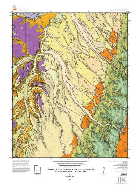
! ! ! ! ! ! ! !UTAH GEOLOGICAL SURVEYa division of<strong>Utah</strong> Department of Natural ResourcesPlate 2<strong>Utah</strong> <strong>Geological</strong> <strong>Survey</strong> Map 262DMGeologic Map of the George Mountain QuadrangleSTRATIGRAPHIC COLUMNGEORGE MOUNTAIN CORRELATION OF MAP UNITSMa2.595.323.055.865.5AGESystem Series and StageCRETACEOUSTERTIARYQUAT.HolocenePleistocenePlioceneMioceneEocene?PaleoceneUpperCampanian83.5 MaSantonian85.8 MaCon.88.6 MaTuronianPLATEMAP UNIT MAP SYMBOL THICKNESS TECTONIC DEPOSITIONALfeet (meters) SETTINGENVIRONMENTconglomerate at Boat MesaClaron FormationWahweap FormationStraight Cliffs Formationvarious surficialdepositsupper Tertiaryfan alluviumLimerock Canyonand Brian HeadFormations, undividedwhite memberupper limestonemiddle intervallower limestonepinkmemberKaiparowits Formationlower unitcapping sandstonememberupper, middle,and lower members,undividedDrip Tank MemberJohn HenryMemberSmoky HollowMemberTibbet CanyonMemberTcwQTafTlbh 290 (88)TbmTcpKklKwcsKwKsdKsjKshKstTcwuTcwmTcwlabout 350 (107)variable150 + (45 + ) alluvial fanand river channel3-15 (1-5)50-80 (15-25)160-220(50-67)40-60(12-18)800 + (245 + )200 + (60 + )200 (60)600 + (180 + )100-200 (30-60)600 + (180 + )125-140 (40-45)120-160 (35-50)Development of intermontaine basins (Paleocene-Eocene) and upliftof Western US (Eocene-Oligocene); uplift continues to present dayforedeep basin of Sevier orogenyLaramide orogenybasin-fill depositscoastal-plain environments intermontaine basinsriver channeland floodplainriver channelnon-volcanicriver and lakesediments modifiedby soil formationfloodplain andriver channelbraided riverfloodplain andriver channelriver channelfloodplainand riverlagoonalestuarinefloodplainbeachand shorefacesand, silt, clay,gravelconglomeratelocal volcaniclastic sandstone,mudstone, and conglomerateand rhyolitic ashpebble conglomeratemicriticlimestonemudstonemicriticlimestonemudstone, siltstone,sandstonesandstone and mudstonesandstone and pebblyconglemeratesandstone, mudstonesiltstonesandstone andpebble conglomeratesandstone, mudstone,siltstonemudstone, siltstonesandstone and minorcoal and coquinalimestonesandstoneDOMINANT ROCK TYPE AND WEATHERING PROFILEnot exposedHenrie Knolls lava flowunconformityunconformitylacks volcanic clastsunconformitywhite limestone ledgewhite limestone ledgeunconformitywhite pebbly sandstoneunconformitywhite sandstone ledge and conglomerateunconformityQUATERNARYTERTIARYCRETACEOUSHolocenePleistocenehistoricalprehistoric11,700upper126,000middle781,000lower2,588,000Pliocene5.3 MaMioceneandOligocene33.9 MaEocene55.8 MaPaleocene65.5 MaUpperCampanianSan.Con.TuronianQal 1QathQaly Qaf 1Qat 2Qat 5Qat 3Qat 4??Taf?unconformityTlbhunconformityTbmTcwuTcwmTcwlTcp?unconformityKwKsdKsjKshKstTcwQaf 2QafyQafoQafo 2? ?unconformityKklKwcsunconformity2?QfMAP SYMBOLSQcQms?QmtContact, dashed where approximately locatedQacQacoQacfQacfoNormal fault, dashed where approximately located, dottedwhere concealed; queried where uncertain; bar and ball ondown-dropped side where knownMarker bed (Tbm), dashed where approximately locatedLandslide main scarpStrike and dip of inclined bedding?QmtcQstQbhkKwView northeast across Johnson Canyon showing the pink member (Tcp) of the Claron Formation in the distant cliffs. The prominent ledgeof white pebbly sandstone in the middle of the photograph is the Drip Tank Member (Ksd) of the Straight Cliffs Formation; the canyonbottom is eroded into the John Henry Member (Ksj). Kw = Wahweap Formation.View north to the Sand Pass fault just southeast of George Mountain in the upper reaches of Johnson Canyon. Here, the fault (in the wash)places the pink member of the Claron Formation down on the east against variegated sandstone and mudstone of the Wahweap Formation.TcpKsdKsj3Approximate strike and dip of inclined beddingSand and gravel pitQuarry (crushed rock)SinkholeSpringGM101508-1Sample location and numberNORTHWESTElevation(feet)AP A U N S A U G U N T P L A T E A USand Pass faultSunset CliffsSOUTHEASTA'Elevation(feet)90008000700060005000Sawyer PointQafTlbhTbmU.S. Highway 89QacfKklKwcsKwKsdTcwTcpQafTlbhKklKwcsKwTcwTcpQaf and surficial depositsQafKsdKsjTcpKklKwcsKwSevier Fault zoneKsjMesozoic, undividedKsdKwTcpKklKwcsKwKsdKsj90008000700060005000Pebbly sandstone and conglomerate of the Drip Tank Member of the Straight Cliffs Formation.KsjKsdMesozoic, undivided4000Upper Cretaceous, undividedKsjsome thin surficial deposits not shown4000
GEOLOGIC MAP OF THE GEORGEMOUNTAIN QUADRANGLE, GARFIELDAND KANE COUNTIES, UTAHby Robert F. BiekMAP 262DMUTAH GEOLOGICAL SURVEYa division ofUTAH DEPARTMENT OF NATURAL RESOURCES2013
GEOLOGIC MAP OF THE GEORGEMOUNTAIN QUADRANGLE, GARFIELDAND KANE COUNTIES, UTAHby Robert F. BiekCover photo: View northeast across Johnson Canyon showing the pink member of theClaron Formation in the distant cliffs. The prominent ledge of white pebbly sandstone inthe middle of the photograph is the Drip Tank Member of the Straight Cliffs Formation; thecanyon bottom is eroded into the John Henry Member.MAP 262DMUTAH GEOLOGICAL SURVEYa division ofUTAH DEPARTMENT OF NATURAL RESOURCES2013
STATE OF UTAHGary R. Herbert, GovernorDEPARTMENT OF NATURAL RESOURCESMichael Styler, Executive DirectorUTAH GEOLOGICAL SURVEYRichard G. Allis, DirectorPUBLICATIONScontactNatural Resources Map & Bookstore1594 W. North TempleSalt Lake City, UT 84116telephone: 801-537-3320toll-free: 1-888-UTAH MAPwebsite: mapstore.utah.<strong>gov</strong>email: geostore@utah.<strong>gov</strong>UTAH GEOLOGICAL SURVEYcontact1594 W. North Temple, Suite 3110Salt Lake City, UT 84116telephone: 801-537-3300website: geology.utah.<strong>gov</strong>Although this product represents the work of professional scientists, the <strong>Utah</strong> Department of Natural Resources,<strong>Utah</strong> <strong>Geological</strong> <strong>Survey</strong>, makes no warranty, expressed or implied, regarding its suitability for a particular use, anddoes not guarantee accuracy or completeness of the data. The <strong>Utah</strong> Department of Natural Resources, <strong>Utah</strong> <strong>Geological</strong><strong>Survey</strong>, shall not be liable under any circumstances for any direct, indirect, special, incidental, or consequentialdamages with respect to claims by users of this product. For use at 1:24,000 scale.This geologic map was funded by the <strong>Utah</strong> <strong>Geological</strong> <strong>Survey</strong> and the U.S. <strong>Geological</strong> <strong>Survey</strong>, National CooperativeGeologic Mapping Program through USGS STATEMAP award number G09AC00152. The views and conclusionscontained in this document are those of the author and should not be interpreted as necessarily representing theofficial policies, either expressed or implied, of the U.S. Government.
GEOLOGIC MAP OF THE GEORGEMOUNTAIN QUADRANGLE, GARFIELDAND KANE COUNTIES, UTAHby Robert F. BiekQal 1MAP UNIT DESCRIPTIONSQUATERNARYAlluvial depositsStream alluvium (Holocene) − Moderately sortedsand, silt, clay, and pebble to boulder gravel depositedin active stream channels and floodplains of theSevier River and Mammoth and Asay Creeks; locallyincludes minor stream-terrace alluvium as muchas about 10 feet (3 m) above current stream level;probably less than 30 feet (
2<strong>Utah</strong> <strong>Geological</strong> <strong>Survey</strong>lies a surface beveled across Limerock Canyon andBrian Head Formations and the upper parts of thewhite member of the Claron Formation; maximumexposed thickness is about 300 feet (90 m).standing the location, age, and stability of landslides,and of slopes that may host as-yet unrecognizedlandslides, requires detailed geotechnicalinvestigations.Talus (Holocene and upper Pleistocene) − Poorlysorted, angular cobbles and boulders and finergrainedinterstitial sediment deposited principallyby rock fall on or at the base of steep slopes; commonlygrades downslope into colluvium; talus iscommon at the base of steep slopes across the maparea, but is only mapped where it conceals contactsor forms broad aprons below cliffs of resistant bedrockunits; typically less than 30 feet (9 m) thick.QfArtificial depositsArtificial fill (Historical) − Engineered fill and generalborrow material used for stock ponds and one areaof Highway 89; fill of variable thickness and compositionshould be anticipated in all developed or disturbedareas; typically less than 20 feet (6 m) thick.QmtColluvial depositsMixed-environment depositsQcQmsColluvium (Holocene and upper Pleistocene) − Poorlyto moderately sorted, angular, clay- to bouldersize,locally derived sediment deposited by slopewash and soil creep on moderate slopes and in shallowdepressions; commonly grades downslope intodeposits of alluvial or mixed alluvial and colluvialorigin; mapped only where it conceals contacts orfills broad depressions; typically less than 20 feet (6m) thick.Mass-movement depositsLandslides (Historical? and upper? Pleistocene) −Very poorly sorted, locally derived material depositedby rotational and translational movement; composedof clay- to boulder-size debris as well as large,partly intact bedrock blocks; characterized by hummockytopography, numerous internal scarps, chaoticbedding attitudes, and common small ponds,marshy depressions, and meadows; largest landslidecomplexes involve mudstone, siltstone, andsandstone interval of the white member (Tcwm) ofthe Claron Formation; undivided as to inferred agebecause even landslides having subdued morphology(suggesting that they are older, weathered, andhave not experienced recent large-scale movement)may continue to exhibit slow creep or are capableof renewed movement if stability thresholds areexceeded (Ashland, 2003); query indicates areas ofunusual morphology that may be due to landsliding;thickness highly variable, but typically several tensof feet or more thick.Vegetation and widespread unmapped colluviummay conceal unmapped landslides, and more detailedimaging techniques such as LiDAR may showthat many slopes host surficial deposits that revealevidence of creep or shallow landsliding. Under-QacQacfQacfoQmtcQstAlluvium and colluvium (Holocene and upper Pleistocene)− Poorly to moderately sorted, generallypoorly stratified, clay- to boulder-size, locally derivedsediment deposited in swales and small drainagesby fluvial, slope-wash, and creep processes;generally less than 20 feet (6 m) thick.Colluvium and fan alluvium (Holocene and upperPleistocene) − Poorly to moderately sorted, poorlyor non-stratified, clay- to boulder-size sediment depositedprincipally by debris flows, debris floods,and slope wash at the mouths of active drainagesand at the base of steep slopes, especially alongthe Claron outcrop belt; locally reworked by small,ephemeral streams; forms coalescing apron of fanalluvium and colluvium not practical to map separatelyat this scale; typically 10 to 40 feet (3–12 m)thick.Older colluvium and fan alluvium (Pleistocene)– Similar to Qacf, but forms incised surface in thesouthwest part of the map area; probably about 20feet (6 m) thick.Talus and colluvium (Holocene and upper Pleistocene)– Poorly sorted, angular to subangular,cobble- to boulder-size and finer-grained interstitialsediment deposited principally by rock fall andslope wash on steep slopes; mapped along the Sevierfault zone; generally less than 40 feet (12 m)thick.Spring depositsCalcareous tufa (Holocene) – Two small areas ofcalcareous spring tufa mapped on the south side ofBig Hollow and along the Sevier fault zone betweenPole and Don Canyon where it forms a thin carapaceover Upper Cretaceous strata.
Geologic map of the George Mountain quadrangle, Garfield and Kane Counties, utah 3Lava Flowquadrangle (Moore and Straub, 1995).These deposits were previously referred to as theSevier River Formation, which was named by Callaghan(1938) for partly consolidated basin-fill depositsnear Sevier, <strong>Utah</strong>, on the north side of theMarysvale volcanic complex (see, for example, Andersonand Rowley, 1975; Anderson and others,1990; Moore and others, 1994; Rowley and others,1994). The name Sevier River Formation formerlyhad value in reconnaissance-scale studies in theHigh Plateaus; in and near its type area, it containsash-fall tuffs that have fission-track and K-Ar ages of14 and 7 Ma and basaltic lava flows that have K-Arages of 9 and 7 Ma (Steven and others, 1979; Bestand others, 1980; Rowley and others, 2002), whichare older than this map unit. In later, more detailedmapping in the High Plateaus, the name Sevier RiverFormation was restricted to its type area for olderbasin-fill sediments deposited in post-20 Ma basins,but that preceded development of the present topography(Rowley and others, 2002) (later basin-filldeposits of the main phase of basin-range deformationin the northern Marysvale area were referredto as “sedimentary basin-fill deposits [QTs]”; Rowleyand others, 2002). J.J. Anderson (verbal communication,November 16, 2004) referred to these depositsas the Panguitch gravels.The Sevier River Formation and other late Tertiarybasin-fill deposits provide control on the structuraldevelopment of the High Plateaus area. Rowley andothers (1981) used K-Ar ages of mapped volcanicrocks in the Sevier Plateau to the north to constrainthe main phase of basin-range faulting to between 8and 5 Ma, during which time the Sevier Plateau wasuplifted along the Sevier fault zone at least 6000feet (2000 m). Pediment deposits preserved atopthe Spry intrusion, about 400 feet (120 m) aboveCircleville Canyon about 20 miles (32 km) northof the map area (Anderson and others, 1990), ledAnderson (1987) to suggest that basin-fill depositsonce filled the ancestral valley of the Sevier Riverto a similar depth above the modern river. However,I see no evidence for such vast exhumation oflate Tertiary fan alluvium in this area. Rather, thestructural high of the Spry intrusion and its cappingpediment deposits may be due to an inferred faultsegment boundary of the Sevier fault zone; thatis, the long-term displacement rate there may belower than that in the basins to the south and tothe north. Thus, I interpret the capping pedimentdeposits simply to be remnants stranded by continueddowncutting of the Sevier River as a result ofdifferential slip on the Sevier fault, not due to exhumationof basin-fill deposits of Circleville Valley andPanguitch valley.Limerock Canyon and Brian Head Formations, undivided(lower Miocene and lower Oligocene toQbhkTafHenrie Knolls lava flows (upper Pleistocene) – Medium-to dark-gray basalt that contains clusters ofolivine and clinopyroxene phenocrysts in an aphaniticto fine-grained groundmass; lava flow eruptedfrom a vent at one of the Henrie Knolls cinder coneswest of the map area and flowed at least 12 miles(19 km) eastward down Wilson Creek and MammothCreek to its confluence with the Sevier River(Biek and others, 2011); major- and trace-elementchemistry is available in (Biek, in preparation); ageunknown, but likely late Pleistocene because thenorth end of the flow complex is incised by TommyCreek and capped by level 4 stream-terrace deposits(Biek and others, 2012); sample HK092106-1near Henrie Knolls yielded a low-precision 40 Ar/ 39 Arage of 0.058 ± 0.035 Ma (UGS and NMGRL, 2009;Biek and others, 2012); lava flow is typically severaltens of feet thick, but is about 80 feet (25 m) thickwhere it fills paleotopography of Mammoth Creek.TERTIARYUpper Tertiary fan alluvium (Pliocene? to Miocene?)– Moderately to poorly consolidated, brownand grayish-brown sandstone, siltstone, pebblysandstone, and conglomerate that forms incised,gently east-tilted surface of low, rounded hills onMammoth Ridge; clasts are of various volcanicrocks (95%) and about 5% quartzite and sandstone(Kurlich and Anderson, 1997); clasts were derivedfrom the west and north from the Mount DuttonFormation and regional ash-flow tuffs and depositedas aggrading alluvial fans, possibly in a structurallyclosed basin later incised by through-going drainageof the Sevier River (Moore and Straub, 1995;Kurlich and Anderson, 1997); includes uncommon,thin, ash-fall tuff beds; lower part on MammothRidge was mapped by Moore and others (1994) aslate Tertiary volcaniclastic deposits that weather toa distinctive, reddish-brown earthy slope that includeschert-pebble conglomerate and pebbly sandstone;unconformably overlies Limerock Canyon/Brian Head strata on Mammoth Ridge; north of themap area, Taf is interbedded with upper Tertiary basalticlava flows (including the 5.0 Ma Rock Canyonlava flow and the 5.3 Ma Dickinson Hill lava flow)and uncommon, thin, lenticular beds of lacustrinelimestone (Biek and others, 2012); only the distaledge of deposits are exposed in the map area,where they are about 150 feet (45 m) thick; the unitis as much as 760 feet (230 m) thick to the north inthe Hatch quadrangle (Kurlich and Anderson, 1997)and at least 1000 feet (300 m) thick in the PanguitchTlbh
4middle Eocene) – Sable and Maldonado (1997b)described the difficulty of differentiating similarvolcaniclastic strata of the Limerock Canyon, BearValley, and Brian Head Formations. We remain uncertainhow to distinguish apparently similar strataof the Brian Head and Limerock Canyon Formationsat Hatch Mountain and areas to the south. The typesection of the Limerock Canyon Formation (west ofHatch, just north of the map area) contains a fewtens of feet of strata that we reassign to the BrianHead Formation, and we suggest that the limestonethat Kurlich and Anderson (1997) assigned to theBrian Head Formation at the base of this type sectionis in fact the upper white member of the ClaronFormation as originally described by Kurlich (1990).White, light-gray, and pale- to olive-green, commonlytuffaceous, volcaniclastic sandstone, pebbly sandstone,gritstone, pebbly conglomerate, mudstone,porcellanite, and minor chalcedony and tuffaceouslimestone; includes at least 10 thin beds of ash-falltuff; contains root casts and is commonly bioturbated;clasts are about 90% volcanic, but include asmuch as 10% quartzite and sandstone; Kurlich andAnderson (1997) stated that the formation lacksNeedles Range, Isom, Bear Valley, and Mount Duttonclasts, but 27- to 26-Ma Isom clasts are indeedabundant and many of the mafic volcanic clasts thatthey reported could be derived from Mount DuttonFormation; mapped at the east edge of the MarkaguntPlateau where it is unconformably overlain byupper Tertiary fan alluvium (Taf) and where it maybe preserved in a subtle basin in front of an inferredblind west-trending thrust fault (the inferred westwardcontinuation of the Ruby’s Inn thrust fault);deposited in fluvial, floodplain, and minor lacustrineenvironments (Kurlich and Anderson, 1997);two ash-fall tuff beds, about 100 feet (30 m) and200 feet (60 m) above the base of the formation atthe type section west of Hatch, respectively, yieldedK-Ar ages of 21.5 ± 0.6 Ma (biotite) and 21.0 ± 1.0Ma (sanidine), and 20.2 ± 1.4 Ma (biotite) and 19.8± 0.8 Ma (sanidine) (Sable and Maldonado, 1997);Sable and Maldonado (1997) also reported 40 Ar/ 39 Arages of 20.48 ± 0.8 Ma (biotite) and 21.0 ± 1.0 Ma(sanidine); Biek and others (2012) reported a U-Pbage on zircon from an ash-fall tuff near the middleof the formation of 20.52 ± 0.49 Ma (UGS andA2Z, Inc., 2013); as much as 290 feet (88 m) thickin a composite type section west of Hatch (Kurlich,1990; Kurlich and Anderson, 1997).unconformityTbm Conglomerate at Boat Mesa (middle Eocene) –Light-gray conglomerate, lesser light-gray to lightbrowncalcareous sandstone and conglomeratic<strong>Utah</strong> <strong>Geological</strong> <strong>Survey</strong>sandstone, and minor white to light-gray limestoneand conglomeratic limestone; clasts are roundedpebbles of black chert, and minor brown, gray, anddistinctive greenish quartzite; no volcanic or intrusiveclasts are present; in the limestone intervals,clasts commonly appear to float in a carbonate mudmatrix, but otherwise the conglomerates are clastsupported; commonly weathers to a chert-pebblecoveredbench or to a white ledge, making it difficultto distinguish from the upper white limestoneunit of the Claron Formation on aerial photographsor from a distance; unconformably overlain by whiteto light-gray volcaniclastic mudstone and sandstoneof the Limerock Canyon and Brian Head Formations(Tlbh); about 3 to 15 feet (1–5 m) thick in the maparea and so locally mapped as a marker bed, but asmuch as 100 feet (30 m) thick at its type area of BoatMesa in Bryce Canyon National Park (Bowers, 1990)and on the southern Sevier Plateau (Biek and others,2012).The conglomerate at Boat Mesa represents depositsof braided stream channels and minor floodplainsincised into deposits of the Claron Formation. Bowers(1990) suggested the conglomerate at BoatMesa was Oligocene and Davis and Pollock (2010)suggested it was Oligocene or Miocene, but a completelack of volcanic clasts suggests a latest middleEocene age, confirmed by a U-Pb age of 36.51 ± 1.69Ma for an overlying basal volcanic ash in the BrianHead Formation on the southwestern Sevier Plateau,and by a U-Pb detrital age on zircon of 37.97+1.78 -2.70 Ma (Gary Hunt, UGS, written communication,March 7, 2012) for this map unit (Tbm) onthe southwest flank of the Sevier Plateau (Biek andothers, 2012; UGS and A2Z Inc., 2013).unconformityClaron Formation (Eocene to Paleocene) – Mapped as fourinformal lithostratigraphic units following the subdivision ofBiek and others (2012) at the west edge of the MarkaguntPlateau: an upper white member (which is itself divided intoan uppermost mudstone interval not present in this maparea, an upper limestone interval, a middle mudstone andsandstone interval, and a lower limestone interval) and thelower pink member. The Claron Formation consists of mudstone,siltstone, sandstone, limestone, and minor conglomeratedeposited in fluvial, floodplain, and lacustrine environmentsof an intermontaine basin bounded by Laramide uplifts(Schneider, 1967; Goldstrand, 1990, 1991, 1992; Taylor,1993; Ott, 1999). Much of the pink member, and clastic partsof the white member, were greatly modified by bioturbationand pedogenic processes, creating a stacked series of paleosols(Mullett and others, 1988a, b; Mullett, 1989; Mullett andWells, 1990; see also Bown and others, 1997). Ott (1999) reportedcyclicity within the Claron Formation at Bryce Canyon
Geologic map of the George Mountain quadrangle, Garfield and Kane Counties, utah 5National Park, with multiple regressive cycles, each exhibitingincreasing pedogenesis toward their tops, stacked oneupon the other. Bown and others (1997) reported on tracefossils of ants, wasps, and bees in the upper part of the pinkmember and lower part of the white member, recording nestactivity during paleosol formation. Hasiotis and Bown (1997)reported on crayfish burrows in Claron strata of the MarkaguntPlateau that record relatively deep and highly fluctuatingwater tables in the pink member, and relatively shallowwater tables in alluvial parts of the white member. Detritalzircon studies of the Claron Formation from the EscalanteMountains east of the map area show that the formationthere was largely derived from erosion of lower Paleozoicsandstones exposed in surrounding Laramide uplifts (Linkand others, 2007; Larsen and others, 2010).The age of the white member is well constrained as late middleEocene (Duchesnean Land Mammal Age) based on sparsevertebrate fossils from this unit on the eastern MarkaguntPlateau (Eaton and others, 2011); by limiting ages of 35.77 ±0.28 Ma and 36.51 ± 1.69 Ma for overlying basal Brian HeadFormation on the Markagunt and Sevier Plateaus, respectively(Biek and others, 2012); and by a U-Pb detrital zircon ageof 37.97 +1.78 -2.70 Ma from the conglomerate at Boat Mesaon the southwestern Sevier Plateau (Biek and others, 2012).Middle Eocene vertebrate fossils and charophytes are alsoknown in basal Brian Head strata on the southwestern SevierPlateau (Eaton and others, 1999; Feist and others, 1997).The maximum age of the mostly nonfossiliferous pink member,however, is poorly constrained as Eocene to Paleocene(?)(Goldstrand, 1994). Goldstrand (1990) reported unspecifiedlate Paleocene palynomorphs from lower Claron strata onthe east side of the Pine Valley Mountains, and noted the Paleoceneto Eocene gastropods Viviparus trochiformis, Physasp., and Goniobasis sp. from the pink member. Goldstrand(1992, 1994) suggested that the pink member may be timetransgressive, being older in western exposures and possiblyno older than middle Eocene on the Table Cliff Plateau. Thisidea, however, was based on fission-track analysis of a singlesample from the underlying Pine Hollow Formation, whichmay be suspect. For one, such a young age seems at oddswith the time required to accummulate such a thick stackof mature paleosols. Larsen and others (2010) suggested alate Paleocene to early Eocene age for the underlying PineHollow Formation on the Table Cliff Plateau, although theynoted a complete lack of fossils, datable ash layers, or ageconstrainingdetrital zircons on which to constrain that assumption.Bowers (1972) also noted a complete lack of datablematerials in the Pine Hollow, and although he preferreda Paleocene(?) age for the formation, he correctly noted thata latest Cretaceous age cannot be ruled out, as did Andersonand Rowley (1975) and Rowley and others (1979). The lowerpart of the pink member is likely Paleocene in age, but givenits paucity of datable materials, we cannot yet rule out thepossibility they are latest Cretaceous.Tcw White member, undivided (Eocene) – Shown oncross section only; about 350 feet (107 m) thick.Tcwu Upper limestone unit of white member (Eocene)– White, pale-yellowish-gray, pinkish-gray, andvery pale orange micritic limestone and pelmicriticlimestone; locally contains intraformational rip-upclasts, sparse charophytes, and rare planispiraledsnails; typically poorly bedded and knobby weathering;locally vuggy with calcite spar and commonlycut by calcite veinlets; resistant and so forms prominentledge; upper unconformable contact with theconglomerate at Boat Mesa (Tbm) corresponds tothe first appearance of chert pebble conglomerate;about 50 to 80 feet (15–25 m) thick; Moore and others(1994) reported that the unit is 80 to 160 feet(24–50 m) thick in the adjacent Asay Bench quadrangle.Tcwm Middle mudstone, siltstone, and sandstone unit ofwhite member (upper middle Eocene) – Varicoloredand commonly mottled, pale-reddish-orange, reddish-brown,moderate-orange-pink, yellowish-gray,dark-yellowish-orange, and grayish-pink calcareousmudstone and siltstone, and minor fine-grainedcalcareous sandstone and chert-pebble conglomeratethat weathers to a poorly exposed slope; upperconformable contact corresponds to a pronouncedcolor change from brightly colored reddish-orangemudstone and siltstone below to white to very paleorange micritic limestone above; Eaton and others(2011) reported the first sparse late middle Eocene(Duchesnean Land Mammal Age) vertebrate fossilsand ostracods of Cypris sp. from this unit on theeastern Markagunt Plateau; about 160 to 220 feet(50–67 m) thick; Moore and others (1994) reportedthat their middle sandy unit is 175 to at least 220feet (54–67 m) thick in the Asay Bench quadrangle.Tcwl Lower limestone unit of white member (Eocene) –Micritic limestone similar to the upper white limestoneunit (Tcwu); appears to be less well developedin southern exposures such that it is difficult to differentiatethe middle interval (Tcwm) from the pinkmember (Tcp); typically forms cliff or steep, ledgy,white slope above more colorful but typically subduedslopes of the pink member (Tcp); containssparse charophytes; upper conformable contactcorresponds to a pronounced color change fromwhite to very pale orange micritic limestone belowto brightly colored reddish-orange mudstone andsiltstone above; about 40 to 60 feet (12–18 m) thick;Moore and others (1994) reported that their lowerwhite limestone is generally 85 to 120 feet (26–36m) thick, but as much as 180 feet (55 m) thick, in theAsay Bench quadrangle.Tcp Pink member (Eocene and Paleocene) − Alternatingbeds of varicolored and commonly mottled, palereddish-orange,reddish-brown, moderate-orange-
6<strong>Utah</strong> <strong>Geological</strong> <strong>Survey</strong>Kklpink, dark-yellowish-orange, and grayish-pink sandyand micritic limestone, calcite-cemented sandstone,calcareous mudstone and siltstone, and minor pebblyconglomerate that weathers to colluvium-coveredledgy slopes; several sinkholes are present inthe northeast part of the map area. Limestone ispoorly bedded, microcrystalline, generally sandywith 2 to 20% fine-grained quartz sand, and is locallyargillaceous; contains common calcite veinlets,calcite spar-filled vugs, calcite spar- and micritefilledburrows, and stylolites; also contains sparsesmall bivalves and planispiral gastropods; many ofthese limestone beds are calcic paleosols (Mullettand others, 1988a, b; Mullett, 1989; Mullett andWells, 1990). Sandstone is thick-bedded, fine- tocoarse-grained, calcareous, locally cross-beddedquartz arenite that typically weathers to sculpted orfluted ledges that pinch out laterally; sandstone locallycontains pebble stringers. Mudstone is generallymoderate reddish orange, silty, calcareous, containscalcareous nodules, and weathers to earthy,steep slopes between ledges of sandstone andlimestone. Pebbly conglomerate is uncommon butforms lenticular beds 5 to 15 feet (2–5 m) thick withrounded limestone, quartzite, and chert pebbles,cobbles, and, locally, small boulders; dark-gray andbluish-gray limestone clasts are common and moreabundant than in Upper Cretaceous strata. Upper,conformable contact corresponds to a pronouncedcolor and lithologic change from brightly coloredreddish-orange mudstone and siltstone below to awhite to very pale orange micritic limestone above.The pink member is mostly unfossiliferous and itsage is poorly constrained as Eocene to Paleocene(?)(Goldstrand, 1994) as described above. Only theupper few tens of feet is exposed west of Highway89; the lower 800 feet (245 m) are exposed in theSunset Cliffs in the southeast part of the map area;the complete pink member is about 1000 feet (300m) thick at Cedar Breaks National Monument andabout 600 feet (180 m) thick at Bryce Canyon NationalPark (Biek and others, 2012).unconformityCRETACEOUSKaiparowits Formation, lower unit (Upper Cretaceous,upper Campanian) – Consists of yellowishbrown,fine-grained sandstone and varicolored andmottled, reddish-brown, purplish-gray, and graymudstone; map unit is best exposed about 5 miles(8 km) to the northeast in Hillsdale Canyon, wheresandstone forms two prominent ledges at the baseand near the middle of the unit and where it is conformablyoverlain by classic blush-gray feldspathicsandstone and mudstone of the Kaiparowits Formation(Biek and others, 2012); in this map area, upper,unconformable contact placed at the base of thefirst sandy limestone bed (calcic paleosol) or pebbleto cobble conglomerate of the pink member of theClaron Formation; incomplete section is about 200feet (60 m) thick in this map area, but the unit isabout 250 feet (75 m) thick in the Hillsdale Canyonarea and thins eastward under the Claron unconformityand is absent in exposures north-northeast ofTropic (Biek and others, 2012).Although undated and lacking bluish-gray feldspathicsandstone and mudstone that characterize thebulk of the Kaiparowits Formation in the KaiparowitsBasin, I assign this interval to an informal lowerunit of the Kaiparowits Formation because it appearslithologically similar to basal Kaiparowits strataalong Henrieville Creek on the west flank of theKaiparowits Plateau (Eaton, 1991) and because it islithologically unlike the underlying capping sandstonemember of the Wahweap Formation. Welle(2008) and Lawton and Bradford (2011) showedthat the lower unit of the Kaiparowits Formation inthe Kaiparowits Basin has a different detrital zirconsignature than that of its middle and upper units,with more thrust-belt-derived grains, recording atransition in sediment source areas from the thrustbelt-sourcedcapping sandstone to arc-derived Kaiparowits.The Kaiparowits Formation was deposited as aneastward-prograding clastic wedge in a relativelywet, subhumid alluvial plain with periodic to seasonalaridity near the western margin of the Late CretaceousWestern Interior Seaway (Roberts, 2007). Itis abundantly fossiliferous, with one of the richestand most diverse terrestrial vertebrate faunas of theCretaceous Western Interior Basin (Roberts, 2007).Roberts and others (2005) reported four 40 Ar/ 39 Arages on sanidine from altered volcanic ashes thatbracket the age of the formation in the KaparowitsBasin between 76.1 and 74.0 Ma, and that demonstrateextremely rapid sediment accumulation ratesof 16 inches/kyr (41 cm/kyr). Biek and others (2012)reported a new U-Pb age on zircon of 75.62 +3.08-1.66 Ma for the bluish-gray smectitic mudstoneat the base of the formation in Johnson Canyon onthe west flank of the Paunsaugunt Plateau, about3 miles (5 km) northeast of the map area (UGS andA2Z, Inc., 2012; Gary Hunt, written communication,September 26, 2011); they also recovered late Campanianto Maastrichtian palynomorphs from this location.Wahweap Formation (Upper Cretaceous, middle Campanian)– Eaton (1991) divided the formation into four informalmembers in the Kaiparowits Basin, originally defined basedprincipally on sandstone to mudstone ratios and fluvial archi-
Geologic map of the George Mountain quadrangle, Garfield and Kane Counties, utah 7tecture. In ascending order, these include his lower, middle,upper, and capping sandstone members. Due to poor exposurein this map area, we map his lower three memberssimply as lower Wahweap Formation, undivided (Kwl). Thedistinctive capping sandstone (Kwcs) is mapped separately.The Wahweap Formation is mostly fine-grained sandstone,siltstone, and mudstone deposited in braided and meanderingriver and floodplain environments of a coastal plain (Tilton,1991; Pollock, 1999; Lawton and others, 2003; Jinnahand others, 2011). Detrital zircon and provenance studies ofEaton’s lower three members show that these rivers flowedlongitudinally to the foreland basin and tapped sources in theCordilleran magmatic arc in southern California or westernNevada and the Mogollon Highlands of southern Arizona, butthat the capping sandstone member was deposited by transversestreams that tapped Mesozoic quartzose sandstones inthe Sevier orogenic belt (Pollock, 1999; Lawton and others,2003; Eaton, 2006; Jinnah and others, 2009). Thus the basalcontact of the capping sandstone member represents anabrupt change in color, petrology, grain size, and fluvial style,documenting a major shift in depositional environmentsfrom meandering to braided rivers, and in source areas fromarc to orogenic belt.Jinnah and others (2009) reported an 40 Ar/ 39 Ar age of 80.6± 0.3 Ma (Campanian) on a devitrified volcanic ash locatedabout 130 feet (40 m) above the base of the Wahweap Formationon the Kaiparowits Plateau, and further noted thatthe formation was deposited between about 81 and 76 Ma.KwcsCapping sandstone member (Upper Cretaceous,middle Campanian) – White to very pale orange, locallyiron stained, very fine to coarse-grained, mostlymedium-grained, trough cross-bedded quartz arenitethat “caps” the Wahweap Formation in its typearea; upper part contains abundant pebble stringersand conglomeratic beds with rounded quartzite, dolomite,chert, and limestone clasts; clasts are typicallyabout 1 inch (2.5 cm) in diameter but as largeas 2 to 3 inches (5–7.5 cm), and include commonreddish-brown and purple quartzite clasts, unlikeunderlying Drip Tank strata; quartz grains are typicallywell rounded and commonly frosted, recycledfrom Mesozoic eolianites (Pollock, 1999; Lawtonand others, 2003); locally contains carbonized orpetrified plant debris, small mudstone rip-up clasts,iron concretions, and soft-sediment deformationfeatures; typically poorly cemented, forming distinctivewhite, manzanita-covered slope-and-benchtopography; Late Cretaceous age from Jinnah andothers (2009), Hunt and others (2011), and Biek andothers (2012); the member is about 200 feet (60m) thick in this map area, but attains its maximumthickness on the Markagunt Plateau of 277 feet (85m) in First Left Hand Canyon southeast of Parowan(this site was the type section of the equivalent andnow abandoned middle member of the redefinedKwGrand Castle Formation) (Biek and others, 2012).Wahweap Formation, upper, middle, and lowermembers, undivided (Upper Cretaceous, middleCampanian) – Yellowish-brown, fine-grainedsandstone and silty sandstone and interbedded,variegated and mottled, brownish-gray, light-olive-brown,pale-reddish-purple, and moderatereddish-brownmudstone and siltstone; becomesincreasingly sandy northward so that stacked oramalgamated sandstone beds make up most of thelower part of the unit north of Big Hollow; query indicatesuncertain designation along the Sevier faultzone north of Pole Canyon; thickness estimates ofthe Wahweap Formation on the west flank of thePaunsaugunt Plateau are complicated by the SandPass fault, which cuts out the middle part of the formation,but in this map area, an incomplete sectionof the Wahweap Formation is as much as about 600feet (180 m) thick; the entire Wahweap Formationis about 1000 to 1100 feet (300–335 m) thick on thewest flank of the Paunsaugunt Plateau (Biek andothers, 2012, after reassigning their map unit Kwuto Kkl).Straight Cliffs Formation (Upper Cretaceous, lower Campanianto Turonian) – Peterson (1969) divided the Straight CliffsFormation into four members in the Kaiparowits Basin: in ascendingorder, the Tibbet Canyon, Smoky Hollow, John Henry,and Drip Tank Members. The Straight Cliffs Formation formsan overall regressive sequence following the last marine incursionof the Western Interior Seaway (see, for example,Eaton and others, 2001; Moore and Straub, 2001; Tibert andothers, 2003). The Tibbet Canyon Member represents initialprogradational (overall regressive) strata of the GreenhornCycle deposited in shoreface, beach, lagoonal, and estuarineenvironments adjacent to a coastal plain (Laurin and Sageman,2001; Tibert and others, 2003). The overlying SmokyHollow, John Henry, and Drip Tank Members were depositedin fluvial and floodplain environments of a coastal plain (Peterson,1969; Eaton and others, 2001).KsdDrip Tank Member (Upper Cretaceous, lower Campanian)– White to light-gray, fine- to coarse-grainedquartzose sandstone, and, in the upper part of theunit, pebbly sandstone, and pebbly conglomerate;very thick bedded with prominent cross-stratification;clasts are subrounded to rounded, white andgray quartzite, gray Paleozoic limestone, and blackchert, and lack the abundant reddish-brown andpurple quartzite clasts found in capping sandstonestrata; locally iron stained and locally contains castsof tree limbs; lower sandstone forms distinctive,manzanita-covered slopes and saddles, but upperpart of unit tends to forms cliffs and ledges; uppercontact with the Wahweap Formation appears to beconformable and corresponds to the top of white
8KsjKshKstsandstone and pebbly sandstone, above which isyellowish-brown, fine-grained sandstone and lesserinterbedded grayish-brown mudstone; Tilton (1991)described the Drip Tank Member as the most prominentand important marker horizon in the UpperCretaceous section on the southern PaunsauguntPlateau, but it is remarkably similar in lithology andoutcrop habit to the capping sandstone member ofthe Wahweap Formation (Biek and others, 2012);deposited by east-and northeast-flowing braidedstreams (Tilton, 1991, 2001a, b); age from Jinnahand others (2009, 2011); ranges from about 100to 200 feet (30–60 m) thick in the map area; Tilton(2001a) reported that the member is 185 to 215feet (56–66 m) thick in the adjacent Alton quadrangle,probably due to differences in picking the uppercontact.unconformityJohn Henry Member (Upper Cretaceous, Santonianto upper Coniacian) – Grayish-orange to yellowishbrown,fine-grained subarkosic sandstone and siltstoneand interbedded, locally mottled, gray, brown,and reddish-brown mudstone; thin- to thick-bedded,forming ledgy slopes; sandstone is commonlybioturbated and locally stained by iron-manganeseoxides; upper unconformable contact correspondsto a break in slope at the base of the white sandstoneof the Drip Tank Member; deposited in fluvialand floodplain environments of a coastal plain(Eaton and others, 2001); incomplete section is asmuch as about 600 feet (180 m) thick in the maparea; Tilton (2001a) reported that the member isabout 670 feet (205 m) thick in the adjacent Altonquadrangle.Smoky Hollow Member (Upper Cretaceous, middleTuronian) – Not exposed, shown on cross sectiononly; Tilton (2001a, b) reported that the member is125 to 140 feet (40–45 m) thick at the south end ofthe Paunsaugunt Plateau.Tibbet Canyon Member (Upper Cretaceous, Turonian)− Not exposed, shown on cross section only; Tilton(2001a, b) reported that the member is about120 to 160 feet (37–50 m) thick at the south end ofthe Paunsaugunt Plateau.ACKNOWLEDGMENTSI thank Jeff Eaton (Weber State University) for sharing hisknowledge of Cretaceous and Tertiary sedimentary strataof southwest <strong>Utah</strong>. Colleagues Grant Willis, Paul Kuehne,Robert Ressetar, and Doug Sprinkel (UGS) provided reviewsof the map and I am grateful for their collective wisdom. Jay<strong>Utah</strong> <strong>Geological</strong> <strong>Survey</strong>Hill (UGS) vectorized the map and drafted plate 2 figures,and Basia Matyjasik (UGS) produced the resulting GIS files.This geologic map was funded by the <strong>Utah</strong> <strong>Geological</strong> <strong>Survey</strong>and U.S. <strong>Geological</strong> <strong>Survey</strong>, National Cooperative GeologicMapping Program, through USGS STATEMAP award numberG09AC00152.REFERENCESAnderson, J.J., 1987, Late Cenozoic drainage history of thenorthern Markagunt Plateau, <strong>Utah</strong>, in Kopp, K.S., andCohenour, R.E., editors, Cenozoic geology of western<strong>Utah</strong>: <strong>Utah</strong> <strong>Geological</strong> Association Publication 16, p.271–278.Anderson, J.J., and Rowley, P.D., 1975, Cenozoic stratigraphyof southwestern high plateaus of <strong>Utah</strong>, in Anderson,J.J., Rowley, P.D., Fleck, R.J., and Nairn, A.E.M., editors,Cenozoic geology of southwestern high plateaus of <strong>Utah</strong>:<strong>Geological</strong> Society of America Special Paper 160, p. 1–51.Anderson, J.J., Rowley, P.D., Blackman, J.T., Mehnert, H.H.,and Grant, T.C., 1990, Geologic map of the CirclevilleCanyon area, southern Tushar Mountains and northernMarkagunt Plateau, Beaver, Garfield, Iron, and PiuteCounties, <strong>Utah</strong>: U.S. <strong>Geological</strong> <strong>Survey</strong> MiscellaneousInvestigations Series Map I-2000, scale 1:50,000.Ashland, F.X., 2003, Characteristics, causes, and implicationsof the 1998 Wasatch Front landslides, <strong>Utah</strong>: <strong>Utah</strong> <strong>Geological</strong><strong>Survey</strong> Special Study 105, 49 p.Best, M.G., McKee, E.H., and Damon, P.E., 1980, Space-timecompositionpatterns of late Cenozoic mafic volcanism,southwestern <strong>Utah</strong> and adjoining areas: American Journalof Science, v. 280, p. 1035–1050.Biek, R.F., Moore, D.W., and Nealey, L.D., 2011, Geologic mapof the Henrie Knolls quadrangle, Garfield, Kane, and IronCounties, <strong>Utah</strong>: <strong>Utah</strong> <strong>Geological</strong> <strong>Survey</strong> Map 252DM, 2plates, scale 1:24,000.Biek, R.F., Rowley, P.D., Anderson, J.J., Maldonado, F., Moore,D.W., Eaton, J.G., Hereford, R., and Matyjasik, B., 2012,Interim geologic map of the Panguitch 30' x 60' quadrangle,Garfield, Iron, and Kane Counties, <strong>Utah</strong>: <strong>Utah</strong><strong>Geological</strong> <strong>Survey</strong> Open-File Report 599, 127 p., 2 plates,scale 1:62,500.Biek, R.F., in preparation, Whole-rock major- and trace-elementgeochemical data for the Panguitch 30' x 60' quadrangle,Garfield, Iron, and Kane Counties, <strong>Utah</strong>: <strong>Utah</strong><strong>Geological</strong> <strong>Survey</strong> Open-File Report.Bowers, W.E., 1972, The Canaan Peak, Pine Hollow, andWasatch Formations in the Table Cliff region, GarfieldCounty, <strong>Utah</strong>: U.S. <strong>Geological</strong> <strong>Survey</strong> Bulletin 1331-B, 39p.Bowers, W.E., 1990, Geologic map of Bryce Canyon NationalPark and vicinity, southwestern <strong>Utah</strong>: U.S. <strong>Geological</strong><strong>Survey</strong> Miscellaneous Investigations Series Map I-2108,15 p., 1 plate, scale 1:24,000.
Geologic map of the George Mountain quadrangle, Garfield and Kane Counties, utah 9Bown, T.M., Hasiotis, S.T., Genise, J.F., Maldonado, F., andBowers, E.M., 1997, Trace fossils of Hymenoptera andother insects, and paleoenvironments of the Claron Formation(Paleocene and Eocene), southwestern <strong>Utah</strong>, inMaldonado, F., and Nealey, L.D., editors, Geologic studiesin the Basin and Range–Colorado Plateau transitionin southeastern Nevada, southwestern <strong>Utah</strong>, and northwesternArizona, 1995: U.S. <strong>Geological</strong> <strong>Survey</strong> Bulletin2153, p. 43–58.Callaghan, E., 1938, Preliminary report on the alunite depositsof the Marysvale region, <strong>Utah</strong>: U.S. <strong>Geological</strong> <strong>Survey</strong>Bulletin 886-D, p. 91–131.Davis, G.H., and Pollock, G.L., 2010, Geology of Bryce CanyonNational Park, in Sprinkel, D.A., Chidesy, T.C., Jr.,and Anderson, P.B., editors, Geology of <strong>Utah</strong>’s parks andmonuments: <strong>Utah</strong> <strong>Geological</strong> Association and Bryce CanyonNatural History Association, <strong>Utah</strong> <strong>Geological</strong> AssociationPublication 28, third edition, p. 37–60.Eaton, J.G., 1991, Biostratigraphic framework for the UpperCretaceous rocks of the Kaiparowits Plateau, southern<strong>Utah</strong>, in Nations, J.D., and Eaton, J.G., editors, Stratigraphy,depositional environments, and sedimentary tectonicsof the western margin, Cretaceous Western InteriorSeaway: <strong>Geological</strong> Society of America Special Paper260, p. 47–63.Eaton, J.G., 2006, Late Cretaceous mammals from CedarCanyon, southwestern <strong>Utah</strong>, in Lucas, S.G., and Sullivan,R.M., editors, Late Cretaceous vertebrates from theWestern Interior: New Mexico Museum of Natural Historyand Science Bulletin 35, p. 373–402.Eaton, J.G., Hutchinson, J.H., Holroyd, P.A., Korth, W.W., andGoldstrand, P.M., 1999, Vertebrates of the turtle basinlocal fauna, middle Eocene, Sevier Plateau, south-central<strong>Utah</strong>, in Gillette, D.D., editor, Vertebrate paleontology in<strong>Utah</strong>: <strong>Utah</strong> <strong>Geological</strong> <strong>Survey</strong> Miscellaneous Publication99-1, p. 463–468.Eaton, J.G., Laurin, J., Kirkland, J.I., Tibert, N.E., Leckie, R.M.,Sageman, B.B., Goldstrand, P.M., Moore, D.W., Straub,A.W., Cobban, W.A., and Dalebout, J.D., 2001, Cretaceousand early Tertiary geology of Cedar and ParowanCanyons, western Markagunt Plateau, <strong>Utah</strong>, in Erskine,M.C., Faulds, J.E., Bartley, J.M., and Rowley, P.D., editors,The geologic transition, High Plateaus to Great Basin—asymposium and field guide (The Mackin Volume): <strong>Utah</strong><strong>Geological</strong> Association and Pacific Section of the AmericanAssociation of Petroleum Geologists, <strong>Utah</strong> <strong>Geological</strong>Association Publication 30, p. 337–363.Eaton, J.G., Tibert, N.E., and Biek, R.F., 2011, First mammalsand ostracodes from the Paleogene Claron Formation,southwestern <strong>Utah</strong> [abs.]: <strong>Geological</strong> Society of AmericaAbstracts with Programs, v. 43, no. 4, p. 77.Feist, M., Eaton, J.G., Brouwers, E.M., and Maldonado, F.,1997, Significance of Charophytes from the lower Tertiaryvariegated and volcaniclastic units, Brian HeadFormation, Casto Canyon area, southern Sevier Plateau,southwestern <strong>Utah</strong>, in Maldonado, F., and Nealey, L.D.,editors, Geologic studies in the Basin and Range–ColoradoPlateau transition in southeastern Nevada, southwestern<strong>Utah</strong>, and northwestern Arizona, 1995: U.S.<strong>Geological</strong> <strong>Survey</strong> Bulletin 2153, p. 27–42.Goldstrand, P.M., 1990, Stratigraphy and paleogeography ofLate Cretaceous and early Tertiary rocks of southwest<strong>Utah</strong>: <strong>Utah</strong> <strong>Geological</strong> <strong>Survey</strong> Miscellaneous Publication90-2, 58 p.Goldstrand, P.M., 1991, Tectonostratigraphy, petrology, andpaleogeography of the Upper Cretaceous to Eocenerocks of southwest <strong>Utah</strong>: Reno, University of Nevada,Ph.D. dissertation, 205 p.Goldstrand, P.M., 1992, Evolution of Late Cretaceous andearly Tertiary basins of southwest <strong>Utah</strong> based on clasticpetrology: Journal of Sedimentary Petrology, v. 62, no. 3,p. 495–507.Goldstrand, P.M., 1994, Tectonic development of Upper Cretaceousto Eocene strata of southwestern <strong>Utah</strong>: <strong>Geological</strong>Society of America Bulletin, v. 106, p. 145–154.Hasiotis, S.T., and Bown, T.M., 1997, Crayfish (Decapoda,Cambaridae) burrows and their paleohydrologic andpaleoenvironmental significance, Paleocene-EoceneClaron Formation, Markagunt Plateau, southwestern<strong>Utah</strong> [abs.]: <strong>Geological</strong> Society of America Abstracts withPrograms, v. 29, no. 2, p. 13.Hunt, G.J., Biek, R.F., DeBlieux, D.D., Madsen, S.K., Milner,A.R.C., Roberts, E.M., and Eaton, J.G., 2011, Dinosaurtracks confirm Late Cretaceous age for the lower GrandCastle Formation, Iron County <strong>Utah</strong>―stratigraphic andtectonic implications [abs.]: <strong>Geological</strong> Society of AmericaAbstracts with Programs, v. 43, no. 4, p. 16.Jinnah, Z.A., and Roberts, E.M., 2011, Facies associations,paleoenvironment, and base-level changes in the UpperCretaceous Wahweap Formation, <strong>Utah</strong>, U.S.A.: Journalof Sedimentary Research, v. 81, p. 266–283.Jinnah, Z.A., Roberts, E.M., Deino, A.L., Larsen, J.S., Link,P.K., and Fanning, C.M., 2009, New 40 Ar/ 39 Ar and detritalzircon U-Pb ages for the Upper Cretaceous Wahweapand Kaiparowits Formations on the Kaiparowits Plateau,<strong>Utah</strong>―implications for regional correlation, provenance,and biostratigraphy: Cretaceous Research, v. 30, p. 287–299.Kurlich, R.A., III, 1990, Geology of the Hatch 7.5 minute quadrangle,Garfield County, southwestern <strong>Utah</strong>: Kent, Ohio,Kent State University, M.S. thesis, 104 p., 2 plates, scale1:24,000.Kurlich, R.A., III, and Anderson, J.J., 1997, Geologic map ofthe Hatch quadrangle, Garfield County, <strong>Utah</strong>: <strong>Utah</strong> <strong>Geological</strong><strong>Survey</strong> Miscellaneous Publication 97-5, 17 p., 2plates, scale 1:24,000.Larsen, J.S., Link, P.K., Roberts, E.M., Tapanila, L., and Fanning,C.M., 2010, Cyclic stratigraphy of the PaleogenePine Hollow Formation and detrital zircon provenance of
10Campanian to Eocene sandstones of the Kaiparowits andTable Cliff basins, south-central <strong>Utah</strong>, in Carney, S.M.,Tabet, D.L., and Johnson, C.L., editors, Geology of southcentral<strong>Utah</strong>: <strong>Utah</strong> <strong>Geological</strong> Association Publication 39,p. 194–224.Laurin, J., and Sageman, B.B., 2001, Cenomanian-Turoniancoastal record in SW <strong>Utah</strong>, U.S.A.―orbital-scale transgressive-regressiveevents during oceanic anoxic eventII: Journal of Sedimentary Research, v. 77, p. 731–756.Lawton, T.F., and Bradford, B.A., 2011, Correlation and provenanceof Upper Cretaceous (Campanian) fluvial strata,<strong>Utah</strong>, U.S.A., from zircon U-Pb geochronology andpetrology: Journal of Sedimentary Research, v. 81, no. 7,p. 495–512.Lawton, T.F., Pollock, S.L., and Robinson, R.A.J., 2003, Integratingsandstone petrology and nonmarine sequencestratigraphy―application to the Late Cretaceous fluvialsystems of southwestern <strong>Utah</strong>, U.S.A.: Journal of SedimentaryResearch, v. 73, no. 3, p. 389-406.Link, P.K., Roberts, E., Fanning, C.M., and Larsen, J.S., 2007,Detrital-zircon age populations from Upper Cretaceousand Paleogene Wahweap, Kaiparowits, Canaan Peak,Pine Hollow, and Claron Formations, Kaiparowits Plateau,<strong>Utah</strong> [abs.]: <strong>Geological</strong> Society of America Abstracts withPrograms, v. 39, no. 5, p. 7.Moore, D.W., Nealey, L.D., and Sable, E.G., 1994, Preliminaryreport, measured sections, and map of the geology ofthe Asay Bench quadrangle, Garfield and Kane Counties,<strong>Utah</strong>: U.S. <strong>Geological</strong> <strong>Survey</strong> Open-File Report 94-10, 26p., 1 plate, scale 1:24,000.Moore, D.W., and Straub, A.W., 1995, Preliminary geologicmap of the Panguitch quadrangle, Garfield County, <strong>Utah</strong>:U.S. <strong>Geological</strong> <strong>Survey</strong> Open-File Report 95-9, 13 p., 1plate, scale 1:24,000.Moore, D.W., and Straub, A.W., 2001, Correlation of UpperCretaceous and Paleogene(?) rocks beneath the ClaronFormation, Crow Creek, western Markagunt Plateau,southwest <strong>Utah</strong>, in Erskine, M.C., Faulds, J.E., Bartley,J.M., and Rowley, P.D., editors, The geologic transition,High Plateaus to Great Basin—a symposium and fieldguide (The Mackin Volume): <strong>Utah</strong> <strong>Geological</strong> Associationand Pacific Section of the American Association of PetroleumGeologists, <strong>Utah</strong> <strong>Geological</strong> Association Publication30, p. 75–95.Mullett, D.J., 1989, Interpreting the early Tertiary Claron Formationof southern <strong>Utah</strong> [abs.]: <strong>Geological</strong> Society ofAmerica Abstracts with Programs, v. 21, no. 5, p. 120.Mullett, D.J., and Wells, N.A., 1990, Soil fabrics and horizontalcracking in the Paleogene Claron Formation of southern<strong>Utah</strong> [abs.]: <strong>Geological</strong> Society of America Abstracts withPrograms, v. 22, no. 7, p. 335.Mullett, D.J., Wells, N.A., and Anderson, J.J., 1988a, EarlyCenozoic deposition in the Cedar-Bryce depocenter―<strong>Utah</strong> <strong>Geological</strong> <strong>Survey</strong>certainties, uncertainties, and comparisons with otherFlagstaff-Green River basins [abs.]: <strong>Geological</strong> Society ofAmerica Abstracts with Programs, v. 20, no. 3, p. 217.Mullett, D.J., Wells, N.A., and Anderson, J.J., 1988b, Unusuallyintense pedogenic modification of the Paleocene-Eocene Claron Formation of southwestern <strong>Utah</strong> [abs.]:<strong>Geological</strong> Society of America Abstracts with Programs,v. 20, no. 5, p. 382.Ott, A.L., 1999, Detailed stratigraphy and stable isotopeanalysis of the Claron Formation, Bryce Canyon NationalPark, southwestern <strong>Utah</strong>: Pullman, Washington StateUniversity, M.S. thesis, 130 p.Peterson, F., 1969, Four new members of the Upper CretaceousStraight Cliffs Formation in southeastern Kaiparowitsregion, Kane County, <strong>Utah</strong>: U.S. <strong>Geological</strong> <strong>Survey</strong>Bulletin 1274-J, p. 1-28.Pollock, S.L., 1999, Provenance, geometry, lithofacies, andage of the Upper Cretaceous Wahweap Formation, Cordilleranforeland basin, southern <strong>Utah</strong>: Las Cruces, NewMexico State University, M.S. thesis, 117 p.Roberts, E.M., 2007, Facies architecture and depositionalenvironments of the Upper Cretaceous Kaiparowits Formation,southern <strong>Utah</strong>: Sedimentary Geology, v. 197, p.207–233.Roberts, E.M., Deino, A.L., and Chan, M.A., 2005, 40 Ar/ 39 Arage of the Kaiparowits Formation, southern <strong>Utah</strong>, andcorrelation of contemporaneous Campanian strata andvertebrate faunas along the margin of the Western InteriorBasin: Cretaceous Research, v. 26, p. 307–318.Rowley, P.D., Cunningham, C.G., Steven, T.A., Workman, J.B.,Anderson, J.J., and Theissen, K.M., 2002, Geologic mapof the central Marysvale volcanic field, southwestern<strong>Utah</strong>: U.S. <strong>Geological</strong> <strong>Survey</strong> Geologic InvestigationsSeries Map I-2645-A, scale 1:100,000.Rowley, P.D., Mehnert, H.H., Naeser, C.W., Snee, L.W., Cunningham,C.G., Steven, T.A., Anderson, J.J., Sable, E.G.,and Anderson, R.E., 1994, Isotopic ages and stratigraphyof Cenozoic rocks of the Marysvale volcanic field andadjacent areas, west-central <strong>Utah</strong>: U.S. <strong>Geological</strong> <strong>Survey</strong>Bulletin 2071, 35 p.Rowley, P.D., Steven, T.A., Anderson, J.J., and Cunningham,C.G., 1979, Cenozoic stratigraphic and structural frameworkof southwestern <strong>Utah</strong>: U.S. <strong>Geological</strong> <strong>Survey</strong> Professionalpaper 1149, 22 p.Rowley, P.D., Steven, T.A., and Mehnert, H.H., 1981, Originand structural implications of upper Miocene rhyolites inKingston Canyon, Piute County, <strong>Utah</strong>: <strong>Geological</strong> Societyof America Bulletin, Part I, v. 92, p. 590–602.Sable, E.G., and Maldonado, F., 1997, The Brian Head Formation(revised) and selected Tertiary sedimentary rockunits, Markagunt Plateau and adjacent areas, southwestern<strong>Utah</strong>, in Maldonado, F., and Nealey, L.D., editors,Geologic studies in the Basin and Range–Colorado Pla-
Geologic map of the George Mountain quadrangle, Garfield and Kane Counties, utah 11teau transition zone in southeastern Nevada, southwestern<strong>Utah</strong>, and northwestern Arizona, 1995: U.S. <strong>Geological</strong><strong>Survey</strong> Bulletin 2153, p. 7–26.Schneider, M.C., 1967, Early Tertiary continental sediments ofcentral and south-central <strong>Utah</strong>: Brigham Young UniversityGeology Studies, v. 14, p. 143–194.Steven, T.A., Cunningham, C.G., Naeser, C.W., and Mehnert,H.H., 1979, Revised stratigraphy and radiometric agesof volcanic rocks and mineral deposits in the Marysvalearea, west-central <strong>Utah</strong>: U.S. <strong>Geological</strong> <strong>Survey</strong> Bulletin1469, 40 p.Taylor, W.J., 1993, Stratigraphic and lithologic analysis of theClaron Formation in southwestern <strong>Utah</strong>: <strong>Utah</strong> <strong>Geological</strong><strong>Survey</strong> Miscellaneous Publication 93-1, 52 p.Tibert, N.E., Leckie, R.M., Eaton, J.G., Kirkland, J.I., Colin, J.P.,Leithold, E.L., and McCormic, M.E., 2003, Recognitionof relative sea-level change in Upper Cretaceous coalbearingstrata―a paleoecological approach using agglutinatedforaminifera and ostracods to detect key stratigraphicsurfaces, in Olson, H.C., and Leckie, R.M., editors,Micropaleontological proxies for sea-level change andstratigraphic discontinuities: Society of Economic Paleontologistsand Mineralogists Special Publication no. 75,p. 263–299.Tilton, T.L., 1991, Upper Cretaceous stratigraphy of the southernPaunsaugunt Plateau, Kane County, <strong>Utah</strong>: Salt LakeCity, University of <strong>Utah</strong>, Ph.D. dissertation, 162 p., scale1:28,160.Tilton, T.L., 2001a, Geologic map of the Alton quadrangle,Kane County, <strong>Utah</strong>: <strong>Utah</strong> <strong>Geological</strong> <strong>Survey</strong> MiscellaneousPublication 01-4, 22 p., 2 plates, scale 1:24,000.Tilton, T.L., 2001b, Geologic map of the Podunk Creek quadrangle,Kane County, <strong>Utah</strong>: <strong>Utah</strong> <strong>Geological</strong> <strong>Survey</strong>Miscellaneous Publication 01-3, 18 p., 2 plates, scale1:24,000.<strong>Utah</strong> <strong>Geological</strong> <strong>Survey</strong> and Apatite to Zircon, Inc, 2013, U-Pbgeochronology results for the Panguitch 30' x 60' quadrangle,<strong>Utah</strong>: <strong>Utah</strong> <strong>Geological</strong> <strong>Survey</strong> Open-File Reportxxx, variously paginated.<strong>Utah</strong> <strong>Geological</strong> <strong>Survey</strong> and New Mexico GeochronologyResearch Laboratory (UGS and NMGRL), 2009, 40 Ar/ 39 Argeochronology results for the Blind Lake, Deer CreekLake, Flat Top, Henrie Knolls, Tabbys Peak, Tabbys PeakSW, Wig Mountain, and Wig Mountain NE quadrangles,<strong>Utah</strong>: <strong>Utah</strong> <strong>Geological</strong> <strong>Survey</strong> Open-File Report 547, variouslypaginated.Welle, B.A., Lawton, T.F., Valencia, V.A., Burns, S., and Middleton,L.T., 2008, Testing the Late Cretaceous Kaiparowits-Mesaverdefluvial conection—a detrital zircon U-Pband petrographic provenance approach [abs.]: <strong>Geological</strong>Society of America Abstracts with Programs, v. 40, no.1, p. 56.


