OXFORD EMPLOYMENT LAND STUDY APPENDICES March 2006
OXFORD EMPLOYMENT LAND STUDY APPENDICES March 2006
OXFORD EMPLOYMENT LAND STUDY APPENDICES March 2006

Create successful ePaper yourself
Turn your PDF publications into a flip-book with our unique Google optimized e-Paper software.
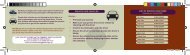
Site: Reference Area (ha)<br />
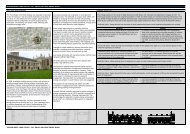
HARROW ROAD INDUSTRIAL ESTATE,<br />
WATLINGTON ROAD<br />
23<br />
4.08<br />
Criteria Comment Score<br />
(out of 5)<br />
Strategic Access<br />
Approximately 11 km. from M40 Junction 8; adjoins A4142 at Cowley<br />
Roundabout; within 3 km. of Headington Roundabout and 5km. to<br />
Hinksey Hill Interchange (for A34)<br />
3<br />
Local Road Access Poor internal road layout, with on-street parking and limited turning<br />
space; junction onto Garsington Road is difficult<br />
2<br />
Public Transport Access Range of bus routes, although frequency is limited (1 per 60 mins) 3<br />
Access to services &<br />
labour<br />
Proximity to incompatible<br />
uses<br />
Site characteristics<br />
Development constraints<br />
General attractiveness<br />
Planning Factors<br />
[Scoring: 5 = best, 1 = worst]<br />
Close to residential areas, but few local services in vicinity, except for 2<br />
Tesco superstore<br />
Within wider industrial / employment location, although some 4<br />
residential areas to south<br />
Large site of regular shape, and generally level 4<br />
No known constraints 4<br />
Small site with reasonably prominent location, but current 2<br />
appearance and condition is poor<br />
Designated as Protected Key Employment Site 4<br />
TOTAL SCORE: 28