Pen Cerrig-calch prehistoric cairns - Clwyd-Powys Archaeological ...
Pen Cerrig-calch prehistoric cairns - Clwyd-Powys Archaeological ...
Pen Cerrig-calch prehistoric cairns - Clwyd-Powys Archaeological ...

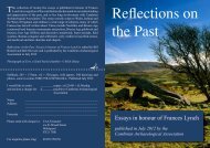
Create successful ePaper yourself
Turn your PDF publications into a flip-book with our unique Google optimized e-Paper software.
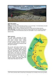
<strong>Pen</strong> <strong>Cerrig</strong>-<strong>calch</strong> <strong>prehistoric</strong> <strong>cairns</strong>Walk Information:Maps: OS Explorer OL13Distance: 8 miles / 13 kilometresDuration: Allow at least 6 hours for the circular walkDifficulty: medium. Some narrow paths, occasionally rough underfootStart and finish: SO 23422027Walk summaryThe walk takes advantage of publicfootpaths and open access land, visiting anumber of <strong>prehistoric</strong> burial <strong>cairns</strong>, and anIron Age hillfort. This is a dramatic ridgewalk with spectacular views across theUsk Valley, the Brecon Beacons and theBlack Mountains.The walk follows a lane before taking a footpath ontothe open moorland and up to Crug Hywel hillfort.Ascending onto the summit of <strong>Pen</strong> <strong>Cerrig</strong>-<strong>calch</strong> theroute passes two burial <strong>cairns</strong> and then follows theeastern edge of the plateau to <strong>Pen</strong> Allt-mawr,returning along the opposite edge, and then retracingthe outward route.CPAT historic landscape walks © <strong>Clwyd</strong>-<strong>Powys</strong> <strong>Archaeological</strong> Trust: available at www.cpat.org.uk/walks1
<strong>Pen</strong> <strong>Cerrig</strong>-<strong>calch</strong> <strong>prehistoric</strong> <strong>cairns</strong>IntroductionThe upland ridge which runs from <strong>Pen</strong> AlltMawr southwards to <strong>Pen</strong> <strong>Cerrig</strong>-<strong>calch</strong> ispredominantly composed of Old RedSandstone. One notable feature, however,is the outcrop of limestone close to thesummit of <strong>Pen</strong> <strong>Cerrig</strong>-<strong>calch</strong> which givesthe area both its name and its distinctivecharacter.This area has a wealth of archaeologicalsites, the earliest of which are numerousburial monuments dating from the BronzeAge (2,300 – 1,200 BC) which arescattered across the ridge top. The stonebuiltburial <strong>cairns</strong> are typical landscapefeatures of the Welsh uplands and wouldhave been erected over inhumations(usually single skeletons), and sometimescremations. There is some evidence forassociated settlement in the form of anenclosure containing a number of small,circular huts. It seems likely that thesemonuments are connected in some waywith the exploitation of upland summer grazing.Crug Hywel HillfortDuring the Iron Age (1200 BC – 74 AD) the local inhabitants built a defendedsettlement, or hillfort, on the summit of Crug Hywel (Table Mountain), a prominentoutcrop at the southern end of the main ridge.The lower slopes on either side of the ridge contain evidence of later human activity inthe form of stock enclosures, field banks, shelters and ‘summer dwellings’, or ‘hafods’,dating from the medieval period onwards. There are also a number of sandstonequarries.The WalkThere is limited parking on the roadsidenear Ty Mawr farm. From Crickhowellfollow signs for Llanbedr, turning right atthe mini roundabout and then first left.Park on the right, immediately after theturning for Llanbedr.It is also possible to start from the maincar park in Crickhowell (SO 21891836),although this would add 2.5 miles to thewalk and involves more road walking.Walk along the road, passing Ty Mawr,and follow the signed route for TableMountain and Perth-y-Pia along aconcrete track. At Perth-y-Pia cross theIron Age hut near the entrance to CrugHywel HillfortCPAT historic landscape walks © <strong>Clwyd</strong>-<strong>Powys</strong> <strong>Archaeological</strong> Trust: available at www.cpat.org.uk/walks2
<strong>Pen</strong> <strong>Cerrig</strong>-<strong>calch</strong> <strong>prehistoric</strong> <strong>cairns</strong>stile on the right of the buildings and follow the fence on the right to a gate which leadsonto the moorland.Continue straight ahead up a steep, grassy slope and bear left below a small crag. Thepath leads upslope to the entrance of Crug Hywel Iron Age hillfort (1) (SO 22602068)with its impressive rock-cut defensive ditch. Once inside the hillfort note the low stonybank of an Iron Age hut just inside the entrance on the left, partly beneath a modernshelter. Follow the top of the ramparts around the south and west sides of the hillfortwhich give spectacular views of the Sugar Loaf, and along the Usk Valley withCrickhowell to the south, as well as north-west towards <strong>Pen</strong>-y-fan in the distance. Aseries of levelled platforms inside the western ramparts mark the position of severalmore Iron Age huts.Follow a narrow path which descendsjust to the east of the northern corner ofthe hillfort. The path crosses a saddleand rises steeply to join a more majortrack rising from the right at SO2237421395. Turn left and follow thetrack, which leads to the summit of <strong>Pen</strong><strong>Cerrig</strong>-<strong>calch</strong>.From the trig point (SO 21708222361) ashort detour to the SSE leads to animpressive Bronze Age burial cairn (2)at SO 2175222233. Return to the trigpoint and continue to a second burialcairn (3), now remodelled into a shelter(SO 21662241).Burial cairn on <strong>Pen</strong> <strong>Cerrig</strong>-<strong>calch</strong>Continue N beyond the cairn and descend to a saddle, following the path around theright hand edge of the plateau, passing a small stone shelter (4) at SO 2082123895and leading to the summit of <strong>Pen</strong> Allt-mawr (SO 20692433). The trig point and shelteroccupy a badly damaged burial cairn (5). There are spectacular views N to MynyddTroed and Castell Dinas, W to <strong>Pen</strong> y Fan and E to the Black Mountains.Head S along a narrow path on the Wedge of the plateau, past anotherprominent Bronze Age burial cairn (6)(SO 2064523870) and on to a furtherburial cairn (7) at <strong>Pen</strong> Gloch-y-pibwr(SO 2020123205). This is believed to bethe site where, on 2nd July 1924, theRector of Llanfihangel Cwm-Du, Rev.W.A. Davies and two companions, tookshelter. They removed stones to a depthof 0.75 m and revealed a ruined cist.Returning the following day theyremoved the covering slab andrecovered several sherds of pottery.Burial cairn on <strong>Pen</strong> Allt MawrCPAT historic landscape walks © <strong>Clwyd</strong>-<strong>Powys</strong> <strong>Archaeological</strong> Trust: available at www.cpat.org.uk/walks3
<strong>Pen</strong> <strong>Cerrig</strong>-<strong>calch</strong> <strong>prehistoric</strong> <strong>cairns</strong>Follow the path E then SE along theplateau edge. At SO 2097022864 takethe narrow path on the right whichcontinues close to the edge, passingtwo circles of stones (8) on the leftwhich may represent <strong>prehistoric</strong>roundhuts (at SO 21012279 and SO21052271). Return to the main track andcontinue back to the summit of <strong>Pen</strong><strong>Cerrig</strong>-<strong>calch</strong>, then retrace the outwardpath across the summit. Descendingtowards Crug Hywel hillfort there are anumber of path options which will takeyou back to the field gate at Perth-y-Pia.Possible <strong>prehistoric</strong> hut below <strong>Pen</strong><strong>Cerrig</strong>-<strong>calch</strong>CPAT historic landscape walks © <strong>Clwyd</strong>-<strong>Powys</strong> <strong>Archaeological</strong> Trust: available at www.cpat.org.uk/walks4
<strong>Pen</strong> <strong>Cerrig</strong>-<strong>calch</strong> BronzeAge burial <strong>cairns</strong>Maps Ordnance Survey Outdoor Leisure 13Distance 8 miles / 13 kilometresDuration Allow at least 6 hours for the circularwalkDifficulty Medium. Some narrow paths,occasionally rough underfootStart/finish SO 23422027There is limited parking on the roadside near TyMawr. From Crickhowell follow signs for Llanbedr,turning right at the mini roundabout and then firstleft. Park on the right, immediately after the turning forLlanbedr.It is also possible to start from the main car park in Crickhowell(SO 21891836), although this would add 2.5 miles to the walkand involves more road walking.Walk along the road, passing Ty Mawr, and follow the signed route left forTable Mountain and Perth-y-Pia along a concrete track. At Perth-y-Pia crossthe stile on the right of the buildings and follow the fence on the right to a gatewhich leads onto the moorland.Continue straight ahead up a steep, grassy slope and bear left below a small crag. The pathleads upslope to the entrance of Crug Hywel Iron Age hillfort 1 (SO 22602068) with itsimpressive rock-cut defensive ditch. Once inside the hillfort, note the low stony bank of anIron Age hut just inside the entrance on the left, partly beneath a modern shelter. Follow the topof the ramparts around the south and west sides of the hillfort which give spectacular views of theSugar Loaf, and along the Usk valley with Crickhowell to the south, as well as north-west towards<strong>Pen</strong>-y-fan in the distance. A series of levelled platforms inside the western ramparts mark the positionof several Iron Age huts.Follow a narrow path which descends just to the east of the northern corner of the hillfort. The path crosses asaddle and rises steeply to join a more major track rising from the right at SO 2237421395. Turn left and followthe track, which leads to the summit of <strong>Pen</strong> <strong>Cerrig</strong>-<strong>calch</strong>.From the trig point (SO 21708222361) a short detour to the SSE leads to animpressive Bronze Age burial cairn 2 at SO 2175222233. Return to the trigpoint and continue to a second burial cairn 3, now remodelled into a shelter (SO21662241).Continue N beyond the cairn and descend to a saddle, following thepath around the right hand edge of the plateau, passing a small stoneshelter 4 at SO 2082123895 and leading to the summit of <strong>Pen</strong> Alltmawr(SO 20692433). The trig point and shelter occupy the remainsof a badly damaged burial cairn 5. There are spectacular viewsN to Mynydd Troed and Castell Dinas, W to <strong>Pen</strong> y Fan and E tothe Black Mountains.Head S along a narrow path on the W edge of the plateau,past another prominent Bronze Age burial cairn 6(SO 2064523870) and on to a further burial cairn 7at <strong>Pen</strong> Gloch-y-pibwr (SO 2020123205).Follow the path E then SE along the plateau edge.At SO 2097022864 take the narrow path on theright which continues along the edge, passingtwo small circles of stones 8 on theleft which may represent <strong>prehistoric</strong>roundhuts (at SO 21012279 and SO21052271).Return to the main track andcontinue back to the summit of<strong>Pen</strong> <strong>Cerrig</strong>-<strong>calch</strong>, then retracethe outward path across thesummit. Descending towardsCrug Hywel hillfort thereare a number of path optionswhich will take you back to thefield gate at Perth-y-Pia.For a fuller description of this walk see www.cpat.org.uk/walksCPAT historic landscape walks © <strong>Clwyd</strong>-<strong>Powys</strong> <strong>Archaeological</strong> Trust