Plan 5 - Cairns Port & Major Industrial Area - Cairns Regional Council
Plan 5 - Cairns Port & Major Industrial Area - Cairns Regional Council
Plan 5 - Cairns Port & Major Industrial Area - Cairns Regional Council

You also want an ePaper? Increase the reach of your titles
YUMPU automatically turns print PDFs into web optimized ePapers that Google loves.
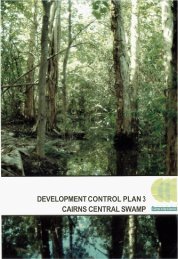
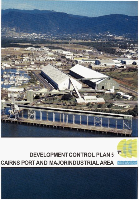
DEVELOPMENT CONTROL PLAN 5CAIRNS PORT AND MAJOR INDUSTRIAL AREA -IFF
(0014)DEVELOPMENT CONTROL PLAN 5CAIRNS PORT AND MAJOR INDUSTRIAL AREAThis Development Control <strong>Plan</strong> applies to the area shown on the Development Control<strong>Plan</strong> map, marked Development Control <strong>Plan</strong> 5 <strong>Cairns</strong> <strong>Port</strong> and <strong>Major</strong> <strong>Industrial</strong> <strong>Area</strong> andto any other areas included by way of amendment. This <strong>Plan</strong> Should be read inconjunction with the <strong>Plan</strong>ning Scheme for part of the City of <strong>Cairns</strong> and is supplementaryto that Scheme.Nothing in this Development Control <strong>Plan</strong> shall be construed to confer any rights to useland for any purpose. Such rights remain vested in the provisions of the Zoning Maps andthe <strong>Plan</strong>ning Scheme Provisions for part of the City of <strong>Cairns</strong>.The Development Control <strong>Plan</strong> includes the map described as Development Control <strong>Plan</strong> 5<strong>Cairns</strong> <strong>Port</strong> and <strong>Major</strong> <strong>Industrial</strong> <strong>Area</strong> and is divided into the following :-1. Introduction2. Definitions3 Aim4 Preferred Dominant Land Uses5 Objectives and Implementation Provisions6 Special Provisions7 Information to be provided by ApplicantsPLANNING STUDYThe <strong>Plan</strong>ning Study provides supporting information which is contained in that documentmarked Development Control <strong>Plan</strong> 5 - <strong>Plan</strong>ning Study, copies of the Study signed foridentification by the Clerk of the Executive <strong>Council</strong> are held at the office of the Director ofHousing, Local Government and <strong>Plan</strong>ning and at the office of the <strong>Cairns</strong> City <strong>Council</strong>.The <strong>Plan</strong>ning Study can be found in Part B of the <strong>Plan</strong>ning Scheme.December 1996
CONTENTSDEVELOPMENT CONTROL PLAN 5CAIRNS PORT AND MAJOR INDUSTRIAL AREA1. INTRODUCTION2. DEFINITIONS3. AIM4. PREFERRED DOMINANT LAND USES4.1 Intent of Designations4.1.1 LighVService Industry Designation4.1.2 General Industry Designation4.1.3 Waterfiont Industry Designation4.1.4 Flammable Industry Designation4.1.5 Conservation Designation4.1.6 Buffer <strong>Area</strong> Designation4.1.7 Special Uses Designation4.1.8 Road Hierarchy4.1.9 Railwayh'ossible Future Public Transport Corridor4.1.10 Landscape StripPAGE1123333333344.2Division of Development Control <strong>Plan</strong> <strong>Area</strong> into Designations5. OBJECTIVES AND IMPLEMENTATION PROVISIONS5.1 LighVService Industry Designation5.1.1 Objectives5.1.2 Implementation5.2 General Industry Designation5.2.1 Objectives5.2.2 Implementation5.3 Waterfront Industry Designation5.3.1 Objectives5.3.2 Implementation5.4 Flammable Industry Designation5.4.1 Objectives5.4.2 Implementation5.5 Conservation Designation5.5.1 Objectives5.5.2 Implementation5.6 Buffer <strong>Area</strong>5.6.1 Objectives5.6.2 Implementation5.7 Traffic and Transportation5.7.1 Objectives5.7.2 Implementation5667889101010111111111111121212
CONTENTS6. SPECIAL PROVISIONS6.1 Acceptable Risk7. INFORMATION TO BE PROVIDED BY APPLICANTS141415
-1-1. INTRODUCTIONIn 1985 the <strong>Cairns</strong> <strong>Area</strong> Development Strategy was released which recommended that, forthe proper long term management of Trinity Inlet and Trinity Bay, the preparation of amanagement plan was a high priority. A strategy covering various issues including:conservation and management of mangrove areas and habitats; port expansion; and portrelated activities was to be formulated.Furthermore, it was recommended that it would be desirable to resolve land use conflict inthe <strong>Port</strong>smith area and to provide for and protect land for waterfront industrial activitiesand rail and road corridors.The implementation proposed by these recommendations was similar and considered to beintegral. It required the preparation of a preferred strategy and Development Control <strong>Plan</strong>,followed by implementation, including declaration of reserves for various purposes. Inorder to complement the Trinity Inlet Management <strong>Plan</strong>, this Development Control <strong>Plan</strong>for the <strong>Cairns</strong> <strong>Port</strong> and <strong>Major</strong> <strong>Industrial</strong> <strong>Area</strong> has been prepared.2. DEFINITIONSIn this Development Control <strong>Plan</strong>, unless the context otherwise indicates or requires, thefollowing terms have the meaning respectively assigned, provided that these terms areapplicable in addition to definitions contained in the <strong>Plan</strong>ning Provisions of the <strong>Plan</strong>ningScheme for part of the City of <strong>Cairns</strong>, as follows :“Risk reduction program” - A written program which sets out measures to beimplemented by an operator against a specified time fiame for the reduction of risk offatality associated with a particular development to a level considered acceptable by<strong>Council</strong>.“Suitably qualijkd expert” - A person and/or organisation with credentials acceptable to<strong>Council</strong>, to undertake a safety and risk analysis of a particular development.“Total Development” - Includes all development both existing on a site and proposedwithin an application before <strong>Council</strong>.
-2-3. AIMThis Development Control <strong>Plan</strong> is intended to achieve the following :- To consolidate and rationalise existing and fume land uses, in order to reducepotential land use conflicts;-To ensure that this area continues to develop and redevelop as the principalindustrial locality for the City and region, within the constraints imposed by theTrinity Inlet Management Program;- To improve the economic and employment bases of the City, whilst ensuring highenvironmental standards for industry;- To encourage industrial development which has a high standard of amenity andfunctionality;- To encourage the orderly and proper development of industry, in accordance withthe Strategic <strong>Plan</strong>;- To encourage industrial diversity;- To promote the efficient use of industrial land; and-To improve the image of industrial areas and industry;It is intended to achieve this aim through the identification of preferred dominant land useareas and the implementation of a series of intents and development criteria, for thesedesignated areas, which will be used to guide consideration of any development proposals.
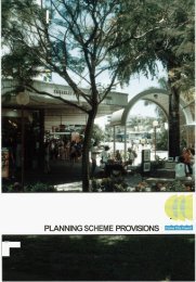
4. PREFERRED DOMINANT LAND USES-3-The location of preferred dominant land uses as described hereunder, is shown on theDevelopment Control <strong>Plan</strong> map.4.1 Intent of Designations4.1.1LightlService Industry DesignationThese areas are located generally to the north of Hartley Street. It is intendedthese areas will provide a buffer area between the General Industry areas locatedin the Development Control <strong>Plan</strong> area and other non-residential uses located inParramatta Park and Bungalow, outside the Development Control <strong>Plan</strong> area. Usesof a light or service industrial nature which conform with relevant developmentcriteria as set out in the <strong>Plan</strong>ning Scheme Provisions, will be permitted in thisdesignated area.4.1.24.1.3General Industry DesignationThis designation identifies land suitable for the development of the bulk ofindustrial uses. It will also cater for those uses which cannot meet thedevelopment criteria set out for development of lighthervice industries.Waterfront Industry DesignationIt is intended that land designated Waterfront Industry and located along TrinityInlet and Smiths Creek will provide for industries which are water orientated.Where an industry does not require direct access to the water, it will not bepermitted to establish on land within this designated area.4.1.4Flammable Industry DesignationThis designation identifies areas which are currentIy occupied by fie1 storagetanks and associated facilities and with which a known degree of risk exists.<strong>Council</strong> recognises that these uses will continue to operate on the sites asindicated in the medium term (i.e. up to the year 2019). It is intended that anyexpansion of these uses shall conform with measures required to ensure thatacceptable degrees of risk, associated with the facilities, are complied with at alltimes.4.1.54.1.6Conservation DesignationThis designation is intended to allow for the implementation of the relevantrecommendations of the Trinity Inlet Management <strong>Plan</strong>, by recognising andprotecting the large tracts of existing mangroves in the <strong>Port</strong>smith area.Development within this designation will generally be precluded.Buffer <strong>Area</strong> DesignationThe buffer area designated on the Development Control <strong>Plan</strong> map is intended tobe established to provide a visual barrier between the <strong>Cairns</strong> Central BusinessDistrict and the Development Control <strong>Plan</strong> area which is predominantly anindustrial area.It is intended that the land shown as buffer will be under the control of <strong>Council</strong>and that landscaping of the area will take place to further provide visual screening.
-4-4.1.74.1.84.1.94.1.10Special Uses DesignationSpecial Uses located within the Development Control <strong>Plan</strong> area include the<strong>Council</strong>’s Refuse Disposal <strong>Area</strong>, Queensland Railways’ shunting yards andHMAS <strong>Cairns</strong>. It is intended that development in these areas will be limited tothe purposes for which the lands are currently used.Road HierarchyThe hierarchy of the road transport system is shown on Map 3, which is containedin the document marked Development Control <strong>Plan</strong> 5 - <strong>Plan</strong>ning Study.RailwayRossible Future Public Transport CorridorThe location of the Spence Street [former] rail corridor, the railway line from theshunting yards to central <strong>Cairns</strong> and the extension of the line to Woree are shownon the Development Control <strong>Plan</strong> map.Landscape StripThe Development Control <strong>Plan</strong> map indicates a landscape strip on either side ofthe Southern Access Road west of Aumuller Street. It is intended the strip of landwill be intensively planted to screen adjacent industrial activities.4.2 Division of Development Control <strong>Plan</strong> <strong>Area</strong> into DesignationsFor the purposes of this Development Control <strong>Plan</strong> the preferred Dominant Land Usedesignations described are indicated on the Development Control <strong>Plan</strong> map with the colourand/or hatching set out in the table below :Preferred Dominant Land UseDesignationColour of HatchingLighUService IndustryGeneral IndustryWaterfront IndustryFlammable IndustryConservationBuffer <strong>Area</strong>Special UsesSouthern Access RoadRailwayPossible Future Public TransportCorridorLandscape StripLight PurpleDark PurpleLight BlueRedLight GreenDark GreenYellowFull black lineLong dashed red linesDashed black line
-5-5. OBJECTIVES AND IMPLEMENTATION PROVISIONS5.1 LiddService Industry Designation5.1.1 Objectives5.1.2 ImplementationTo provide specific areas for the establishment of industrial uses of a lightand/or service nature, as defined by the <strong>Plan</strong>ning Scheme for part of the Cityof <strong>Cairns</strong>.To ensure orderly and functionally efficient development which is readilyaccessible.To locate lightlservice industrial uses such that they form a transition fromgeneral industries to the primarily non-industridcommercial uses locatedadjacent to Mulgrave Road, thereby buffering non-industrial uses to thenorth of the Development Control <strong>Plan</strong> area.To identify the location of the Gas Works and limit expansion of theoperations in order that any risk associated with the operations of the worksis not exacerbated.To create effective buffers between industrial and residential areas byseparating , by distance, the more incompatible activities and by requiringthe provision of screen planting and landscaping around industrial buildingsand on industrial sites. On street planting will also be required.To promote the upgrading of existing industrial activities, with unacceptableenvironmental performance, located close to residences.To encourage industrial diversity by providing an area for the location ofservice based industries.To provide a visually attractive built and natural environment within thisindustrial area.To protect the amenity of adjoining and nearby residential areas.To ensure that vehicular traffic generated by industry does not conflict withlocal or through traffic, or cause detriment within the immediate vicinity orto the general community.To provide a program of improvements to industrial streets and on-streettree planting.(a)The Development Control <strong>Plan</strong> map shows areas considered suitable fordevelopment for light and/or service industries which facilitate thefulfilment of the above objectives.It is intended that land in this area will be used for lightlservice industrialtype uses, providing a transition area between the commercial uses locatedoutside the Development Control <strong>Plan</strong> area, adjacent to Mulgrave Road, andthe general industrial uses located generally south of Hartley Street.Land in this designation is zoned for light and service industries due to thesmaller allotment sizes in this area. Applications for general industries shallnot be approved as insufficient area is available on these smaller sites tobuffer them from neighbouring land.
-6-(b)(c)Other more intensive industrial uses which require larger sites will not bepermitted to establish in this designated area, in order that existing smallerunits of similar style industrial activities are not adversely affected.This designation includes the site currently developed with the Gas Works.It is <strong>Council</strong>’s intention that the Gas Works should be relocated fiom itspresent site. This intention is based on the high degree of risk associatedwith the location of the existing works. It may be that the risk of fatalitywill increase when redevelopment of the <strong>Cairns</strong> Railway Station site isundertaken, depending on the location of uses within that redevelopment.<strong>Council</strong> shall not approve expansion of the existing facility. Anyapplication for rationalisation (but not expansion) of the use will beaccompanied by a detailed Risk Analysis Report prepared by a suitablyqualified expert which shall specify appropriate risk reduction measures, inthe form of a risk reduction program.Any application which will increase the risk associated with the works willnot be approved.(d)(e)(f)Where a site in the LighVService Industry Designation has a commonboundary with the land in a Residential zone, Sport and Recreation zone,Conservation zone or Open Space zone :- no part of any building or structure above the level of adjoiningground shall be within a distance measured on a horizontal plane of:-2.5 metres; orequivalent to half the height of that part, whichever is thegreater, from a side boundary of the site;no part of any building or structure above the level of adjoiningground shall be within a distance measured on a horizontal plane of 6metres from the rear boundary of the siteWhere a site in the LighVService Industry Designation has a commonboundary with a street that abuts a Residential zone, land zoned for Sportand Recreation, an Open Space zone or a Buffer area :- no part of any building or structure shall be located within a 6 metressetback from the street; and-the setback shall be densely landscaped with advanced trees andshrubs.Other development provisions to be satisfied are contained in the <strong>Plan</strong>ningScheme Provisions and relevant Local Laws.5.2 General Industry Designation5.2.1 Objectives(a)(b)(c)To ensure orderly and functionally efficient development which is readilyaccessible.To protect from encroachment by non-industrial uses or less intensiveindustrial uses, land which is designated to provide for the establishment ofgeneral industries.To recognise the existing CIG storage facility and provide controls whichensure that risk associated with operations of the facility will not beexacerbated.
-7-(d)(e)(0(g)(h)To limit any potentially adverse effects of general industrial development onland adjoining areas designated for conservation.To accommodate a wide range of industrial and related developments asspecified in the <strong>Plan</strong>ning Scheme for part of the City of <strong>Cairns</strong>.To improve the image of general industry areas and industry.To protect the amenity of adjoining residential areas.To provide a program of improvements to industrial streets and owstreettree planting.5.2.2ImplementationThis designation includes the majority of land available for theestablishment of general industries and forms the core area for thedevelopment and continuation of general industry for the City of <strong>Cairns</strong>.Land in this designation shall not be used for purposes which in <strong>Council</strong>’sopinion would be more appropriately located in other areas providing forless intensive industrial development, such as areas designated forlighthervice industry or commercial areas.Non-industrial uses will not be permitted to establish, as specified in the<strong>Plan</strong>ning Scheme Provisions.<strong>Council</strong> may give consideration to applications for rezoning to allowHazardous or Offensive Industries , subject to the results and conclusions ofan Environmental Impact Statement, showing that a proposed use would notcause unreasonable detriment to the amenity of existing or likely futuresurrounding land uses and the area generally.<strong>Council</strong> may also permit the establishment of High-Tech Industries in thisdesignation, subject to the relevant provisions of the Town <strong>Plan</strong>ning Schemefor part of the City of <strong>Cairns</strong>.<strong>Council</strong> will not permit the establishment of any uses which in <strong>Council</strong>’sopinion generate the movement of unnecessary traffk into or through thedesignated area.Where land adjoins wetland areas designated for conservation, developmentshall not detrimentally affect neighbouring conservation areas by way ofcontaminated runoff, spillage, emissions and use of material etc. likely topollute the immediate environment.Where proposals adjoin wetland areas, <strong>Council</strong> may subject developmentsto the following types of requirements :fencingbunding- landscaped bufferingmanagement of toxic and hazardous wastesperimeter interception drains0 setbacksProposals may also require approval from the Trinity Inlet ManagementProgram and the submission of an Environmental Impact Statement mayalso be required.
-8-(g)The designated area includes the site currently developed withe the CIGfacility. <strong>Council</strong> does not favour expansion of the current facility on thissite due to the limited site area available and the degree of risk to adjacentland associated with the existing facility.Favourable consideration may be given to rationalisation (but notexpansion) of the existing facility, where an application to <strong>Council</strong> isaccompanied by a detailed report prepared by a suitably qualified expertwhich analyses risk associated with the total development on the site andspecifies an appropriate risk reduction program to the level of risk which<strong>Council</strong> considers is acceptable. Depending on the scale of the proposedworks, an Environmental Impact Statement may also be required.(h)(i)(j)Where a site in the General Industry Designation has a common boundarywith land in a Conservation zone, Sport and Recreation zone or Open Spacezone :- no part of any building or structure above the level of adjoiningground shall be within a distance measured on a horizontal plane of:-2.5 metres; orequivalent to half the height of that part, whichever is thegreater, from a side boundary of the site;no part of any building or structure above the level of adjoiningground shall be within a distance measured on a horizontal plane of 6metres from the rear boundary of the site.Where a site in the General Industry designation has a common boundarywith a street that abuts a Residential zone, land zoned for Sport andRecreation, an Open Space zone or a Buffer <strong>Area</strong> :- no part of any building or structure shall be located within a 6 metresetback from the street; and-the setback shall be densely landscaped with advanced trees andshrubs.Other development provisions to be satisfied are contained in the <strong>Plan</strong>ningScheme Provisions and relevant Local Laws.5.3 Waterfront Industry Designation5.3.1 Objectives(a)(b)(c)(d)(e)(f)To provide for the establishment of industrial uses which require directaccess or frontage to the waterfront of the <strong>Port</strong> of <strong>Cairns</strong>.To ensure that the limited supply of land with direct water frontage is notalienated by uses not requiring such frontage.To prevent any potentially adverse effects the development of waterfrontland may have on Trinity Inlet and Smith's Creek.To encourage the adoption and achievement of high environmental andhealth performance standards.To ensure orderly and functionally efficient development which is readilyacceptable.To provide a program of improvements to industrial streets and on-streettree planting.
5.3.2 Implementation-9-(a)(b)(c)Land in this designation shall only be available for water oriented industrialuses. Other uses, including other industrial uses, which do not require directfrontage to the water shall not be permitted to establish on land in thisdesignation.Developers and operators of waterfront industries fronting Trinity Inlet andSmith's Creek shall not permit any action or operation to occur which willdetrimentally affect such adjoining watercourse and/or the conservationarea. <strong>Council</strong> may impose specific conditions to ensure that neitherwatercourses or the conservation area are detrimentally affected.<strong>Council</strong> may require developments within the Waterfront Industrydesignation to obtain approval from the Trinity Inlet Management Programand to submit an Environmental Impact Statement.Where land adjoins wetland areas designated for conservation, developmentshall not detrimentally affect neighbouring conservation areas, Trinity Inlet,Smiths and Chinaman Creeks by way of contaminated run-off, spillage,emissions, and use of materials etc. likely to pollute the immediateenvironment.Where proposals adjoin wetland areas, <strong>Council</strong> may subject developmentsto the following types of requirements:-* fencingbundinglandscaped bufferingmanagement of toxic and hazardous wastesperimeter interceptor drainssetbacksIf a particular development does not satisfy the requirements of anEnvironmental Impact Statement or the requirements of the Trinity InletManagement Program, Department of Environment and Heritage, and<strong>Council</strong>, with regard to the possible impact on Trinity Inlet, Smiths andChinaman Creeks, the proposal shall not obtain approval to locate withinthis area.(d)(e)(9Where a site in the Waterfront Industry Designation has a commonboundary with land in a Conservation zone or the Buffer <strong>Area</strong>:- no part of any building or structure above the level of adjoiningground, shall be within a distance measured on a horizontal plan of :--6metres;orequivalent to half the height of that part, whichever is the greaterfrom the boundary of the site;Where a site in the Waterfront Industry Designation has a commonboundary with Trinity Inlet and/or Smiths Creek :---the setback shall be densely landscaped with mature trees.no part of any building shall be:within a distance of 10 metres from the point of the highestastronomical tide;the setback shall be landscaped with advanced trees and shrubs.<strong>Council</strong> may vary these setbacks at its discretion, however, documentationshall be submitted providing reasons to substantiate the variation.
-1 I-(d)(e)<strong>Council</strong> may require, as a condition of approval, that an annual audit of fuelstorage facilities and other flammable facilities be undertaken, to ensurecompliance with all requirements.All development proposals shall be referred to the Technical Committee ofthe Trinity Inlet Management Program for consideration and therecommendations of the Trinity Inlet Management Program will be takeninto account by <strong>Council</strong> when considering the proposal.5.5 Conservation Designation5.5.1. Objectives(a)(b)5.5.2. Implementation(a)To protect the existing wetland areas which fringe Smiths and ChinamanCreeks from encroachment by industrial development;To implement the provisions of the Trinity Inlet Management <strong>Plan</strong>, insofaras they relate to existing undisturbed wetland areas.<strong>Council</strong> will not approve industrial development in the area designated asConservation.(b)(c)(d)Notwithstanding (a) above, <strong>Council</strong> may approve minor developments suchas interpretive walks or interpretive centres where <strong>Council</strong> is satisfied thatthe wetland area will not suffer deleteriously from any proposedconstruction.Wetland areas within the area designated as Conservation shall not becleared nor shall filling be placed on any wetland areas, except pursuant toany approval issued by <strong>Council</strong> pursuant to (b) above.Developments such as those specified in Section 5.5.2.(b) shall be referredto the Technical Committee of the Trinity Inlet Management Program forconsideration and the recommendations of the Trinity Inlet ManagementProgram will be taken into account by <strong>Council</strong> when considering theproposal.5.6 Buffer <strong>Area</strong>5.6.1. Objectives(a)@)(c)(d)5.6.2. ImplementationTo provide an area of visual screening between the Central Business Districtand industrial development, located within the Development Control <strong>Plan</strong>area.To delineate an identifiable boundary beyond which the business area shallnot intrude into the principle industrial area of the City.To improve the visual image of industrial areas.To provide a program of improvements to industrial streets and on-streettree planting.(a)It is <strong>Council</strong>’s intention that control of a strip of land, with a minimumwidth of 8 metres and located generally adjacent to the eastern boundary ofDutton Street between Kenny Street and Spence Street, should betransferred to <strong>Council</strong>.
-12-The area shall be planted and landscaped to provide a visual and physicalbuffer between industrial uses to the west and the Central Business Districtto the east. The area between Dutton Street and the new alignment of therailway line, between Kenny Street and Spence Street, is a suitable locationfor this section of the Buffer <strong>Area</strong>.(b)A strip of land, with a minimum width of 6 metres and located at thefrontage of the properties to Kenny StreeVWharf Street and across thenorthern edge of the Development Control <strong>Plan</strong> area, as shown on theDevelopment Control <strong>Plan</strong> map, shall be provided as a landscaped bufferbetween the port operations and the Central Business District. <strong>Council</strong> mayrequire or negotiate the transfer of this land to <strong>Council</strong>’s control.5.7 Traffic and Transportation5.7.1. Objectives(a)(b)(c)(d)To ensure high standards of mobility and accessibility within and throughthe Development Control <strong>Plan</strong> area.To ensure a proper relationship between the type and intensity of land useand the existing and future road and rail systems.To maintain the integrity of the <strong>Cairns</strong> Southern Access Road.To minimise on-street carparking, by ensuring adequate off-streetcarparlung.(e)(95.7.2 ImplementationTo ensure that vehicular traffic generated by industry does not conflict withlocal or through traffic, or cause detriment within the immediate vicinity orto the general community.To ensure the preservation of the Spence Street rail corridor.(a) Map 3, contained in the document marked Development Control <strong>Plan</strong> 5 -<strong>Plan</strong>ning Study, identifies the preferred hierarchy for roads within theDevelopment Control <strong>Plan</strong> area.(b)(c)(d)(e)<strong>Council</strong> intends to safeguard the existing and future capacity of the roadsystem, within the Development Control <strong>Plan</strong> area, by limiting andcontrolling vehicle access from sites fronting heavily traffklced roads and byrestricting the layout and intensity of development along such roads.The need for the provision of adequate on-site parking is recognised andrequired by the <strong>Plan</strong>ning Scheme Provisions. The design and layout ofmanoeuvring and parlung areas shall ensure that such areas are attractive touse. A significant proportion of the required amount of parlung forcommercial and industrial development shall be provided at a visiblelocation at the front or side of the site.The Development Control <strong>Plan</strong> map identifies the Woree to <strong>Cairns</strong> route ofthe Main North Line of the Queensland Railways. This line will service themarshalling yards located west of Aumuller Street and the <strong>Port</strong> areagenerally.The Development Control <strong>Plan</strong> map identifies the Spence Street [former]rail corridor. This corridor is to be preserved to enable future publictransport access to the Centrd Business District.
-13-(f)(g)The Development Control <strong>Plan</strong> map identifies the <strong>Cairns</strong> Southern AccessRoad (CSAR) which connects the Central Business District to the BruceHighway at Woree. Wherever possible, <strong>Council</strong> will require developmentwith frontage to this road to gain access via alternative streets. In this way,and by requiring combined access points, <strong>Council</strong> will endeavour to limitdirect access onto this road.It shall be a requirement of all development on land west of Aumuller Streetand with frontage to the <strong>Cairns</strong> Southern Access Road, that a six (6) metrewide landscape area shall be established across the whole of the frontage ofthe land. The landscape area shall be planted and maintained to <strong>Council</strong>’ssatisfaction, in accordance with a landscape plan prepared by a suitablyqualified landscape architect, and approved by <strong>Council</strong> at the time of issuinga building approval.
~ Land-14-6.6.1UseRisk of fatality criteriaper million per person per yearHospitals, schools, old age housing andchild care facilitiesResidentialOpenspace - Passive- ActiveCommercialPublic Roads<strong>Industrial</strong>Up to 0.5up to 1up to 10up to 5up to 5up to 20Up to 50 per employeeIn detail, the criteria are as follows :-Hospitals, schools, child-care facilities and old age housing development shouldnot be exposed to individual fatality risk levels in excess of half in one million peryear.Residential developments and places of continuous occupancy, such as hotels andtourist resorts should not be exposed to individual fatality risk levels in excess ofone in one million per year.Commercial developments, including offices, retail centres, warehouses withshowrooms, restaurants and entertainment centres, should not be exposed toindividual fatality risk levels in excess of five in one million per year.Sporting complexes and active open space areas should not be exposed toindividual fatality risk levels in excess of ten in one million per year.Individual fatality risk levels for industrial sites at levels of 50 in one million peryear should, as a target, be contained within the boundaries of the site whereapplicable.
-15-7. INFORMATION TO BE PROVIDED BY APPLICANTS- Five (5) copies of site layout plan, showing details of all buildings and works,both existing and proposed.----Internal layout of all buildings showing plant and equipment.Details and plans, where applicable, of any emissions either to air, water or land,including means of discharge and control.Complete details of the total operation or processes carried out, includingmaterials used, products produced and any by-products produced, includingdetails of the method of their disposal and/or treatment.Details of any potential risk or hazard in either the processes carried on ormaterials stored or ultimately produced.- Hours of operation.- Numbers of staff, including office, manufacturing, warehouse, salesrepresentatives and the like.-------Details of the transportation of raw materials, finished products, by-products orwaste to and from the site, including the means of transport and the frequency ofvehicle movements.Any example of a similar activity or process operating elsewhere which could beinspected by <strong>Council</strong> if need be.If relocating from elsewhere, the location and zoning of the exiting site and thereasons for relocation.Details of any discussions held with other authorities, such as Department ofEnvironment and Heritage or Department of Primary Industries, regarding thisapplication.Details (if any) of ultimate scale of development proposed for the site.Any other comment or information that you consider would assist <strong>Council</strong> in thedetermination of the application.Any additional documentation specified within the Development Control <strong>Plan</strong>.Upon receipt of the above information, the application together with the material supplied,may be referred to a number of relevant authorities, including the Department ofEnvironment and Heritage and the Trinity Inlet Management Program, for advice on theproposal.
DEVELOPMENT CONTROL PLAN 5CAIRNS PORTMAJOR IND JSTRIAINDJ AREALEGENDDCP <strong>Area</strong>Lig h t/Service IndustryGeneral IndustryWaterfront IndustryFlammable IndustryConservationBuffer <strong>Area</strong>Special Use<strong>Area</strong> of <strong>Regional</strong> Significancefor Business and IndustryDevelopment....... i..........---Southern Access RoadLandscape StripRailway/Possible FuturePublic Transport CorridorPossible Future Marina SiteLAND USEDESIGN AT1 ONSI W - W I7m 0 uolmm4wswc.nScale 1 : 15,000 December, 1996DO NOT SCALE