

Calibration of a Terrestrial Laser Scanner - Institute of Geodesy and ...
Calibration of a Terrestrial Laser Scanner - Institute of Geodesy and ...
Calibration of a Terrestrial Laser Scanner - Institute of Geodesy and ...

Create successful ePaper yourself
Turn your PDF publications into a flip-book with our unique Google optimized e-Paper software.
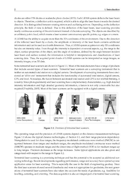
2 1. Introductiondiodes are either PIN diodes or avalanche photo diodes (APD). Each LiDAR system deflects the laser beamto objects. Therefore, a deflection unit is required, which is able to alignthe laser beam towards the desireddirection. It is distinguished between rotating mirrors <strong>and</strong> oscillating mirrors. Dependingon the deflectionprinciple, the field <strong>of</strong> view is defined. Due to this deflection <strong>of</strong> the laser beam, laser scanning providesnearly continuous scanning <strong>of</strong> the environment instead <strong>of</strong> discrete surveying. The objects are described byan arbitrary point cloud, which means a laser scanner cannot survey specific points, e.g. edgesA LiDAR has the ability to acquireor corners.more than the 3D coordinates <strong>of</strong> the environment. Due to the detection<strong>of</strong> the reflected laser beam by a diode, the amplitude or intensity<strong>of</strong> the laser beam contains additionalinformation <strong>and</strong> can be used as a fourth dimension. Thus, a LiDAR system acquires not only 3D coordinatesbut also an intensity value. Even though the intensity is dependent on several aspects, e.g. the rangeobject, surface properties <strong>of</strong> the object, <strong>and</strong> the angle <strong>of</strong> incidence, defined by the angleto thebetween incidentlaser beam <strong>and</strong> surface normal, the information is helpful in interpretations <strong>and</strong> classifications <strong>of</strong> laserscanning data.intensity images,Thus, the acquired point clouds <strong>of</strong> LiDAR systems can be interpreted as range images, asor as 3D data.Some terrestrial laser scanners are shown in Figure 1.1. Most <strong>of</strong> the manufacturers have a range <strong>of</strong> productsthat include several types<strong>of</strong> laser scanners. <strong>Terrestrial</strong>laser scanners are a surveyinginstrument that isneither an automated total station nor a digital camera. Development <strong>of</strong> surveyinginstruments have envi¬sioned an 'all-in-one' instrument that includes the functionality <strong>of</strong> automated total station, digital camera,GPS, <strong>and</strong> level. Nowadays, the fusion between automated total station <strong>and</strong> GPS is not wishful thinking, itis reality. Since photogrammetry <strong>and</strong> laser scanning have complementary characteristics, e.g. high detailedintensity information <strong>and</strong> high detailed geometry information, a fusion isnot onlyconceivable but alsorequired [Przybilla, 2005]. Most <strong>of</strong> the laser scanners can be equipped with a digital camera.HDS 3000Leica GeosystemsGXTrimbleLMS-Z420iRieglIMAGER 5003Zoller+FröhlichLS 420 HE 20Faro TechnologiesCPW 8000CallidusFigure 1.1:Overview <strong>of</strong> terrestrial laser scanners.The operating range <strong>and</strong> the precision <strong>of</strong> LiDAR systems depend on the distance measurement technique.Figure 1.2 shows the typical distance technologies, cf. Section 2.1, <strong>and</strong> their range-precision-dependency.Triangulation is used for close ranges, the frequency-modulated continuous wave method (FMCW) is cat¬egorized between close ranges <strong>and</strong> medium ranges, the amplitude-modulatedcontinuous wave method(AMCW) operates in medium ranges <strong>and</strong> the direct time-<strong>of</strong>-flight method (TOF) is for medium ranges upto long ranges. Precision decreases as the range increases. Some typical applications are also given <strong>and</strong>categorized with respect to the range in Figure 1.2.<strong>Terrestrial</strong> laser scanning is a promising technique <strong>and</strong> has the potential to be acceptedas additional sur¬veying technology. Recent developments regarding performance, range <strong>and</strong> accuracy have opened up newapplication areas for laser scanning. This is especially the case in the field <strong>of</strong> engineering geodesy. Sincethe first laser scanners showed several drawbacks <strong>and</strong> were not appropriate for geodesists, the next gener¬ations <strong>of</strong> terrestrial laser scanners have also taken into account the needs <strong>of</strong> geodesists, e.g. feasibility forlevelling, centering, <strong>and</strong> orienting. The data acquisition is also an integral part <strong>of</strong> terrestrial laser scanning.


