Filter BermsGabionsGeotextilesGradient TerracesGrass-Lined ChannelsGrid PaversL<strong>and</strong> GradingLog CribbingMulchingPreserving NaturalVegetationReinforced ConcreteRiprapSediment Basins <strong>and</strong>Rock DamsA gravel or stone filter berm is a temporary ridge made up of loose gravel, stone, orcrushed rock that slows, filters, <strong>and</strong> diverts flow from an open traffic area <strong>and</strong> acts asan efficient form of sediment control. A specific type of filter berm is the continuousberm, a geosynthetic fabric that encapsulates s<strong>and</strong>, rock, or soil.Gabions consist of coarse aggregates set in wire gabion baskets <strong>and</strong> are aligned in aterraced wall formation. They are installed to prevent non-desired fish passagebetween water bodies while maintaining water flow <strong>and</strong> to control erosive seasonalwater flows.Geotextiles are porous fabrics also known as filter fabrics, road rugs, syntheticfabrics, construction fabrics, or simply fabrics. Geotextiles are manufactured byweaving or bonding fibers made from synthetic materials such as polypropylene,polyester, polyethylene, nylon, polyvinyl chloride, glass, <strong>and</strong> various mixtures ofthese materials. As a synthetic construction material, geotextiles are used for avariety of purposes such as separators, reinforcement, filtration <strong>and</strong> drainage, <strong>and</strong>erosion control.Gradient terraces are made of either earthen embankments or ridge <strong>and</strong> channelsystems that are properly spaced <strong>and</strong> are constructed with an adequate grade. Theyreduce damage from erosion by collecting <strong>and</strong> redistributing surface runoff to stableoutlets at slower speeds <strong>and</strong> by increasing the distance of overl<strong>and</strong> runoff flow.Grass-lined channels convey storm water runoff through a stable conduit. Vegetationlining the channel reduces the flow velocity of concentrated runoff. Grassedchannels usually are not designed to control peak runoff loads by themselves <strong>and</strong> areoften used in combination with other BMPs, such as subsurface drains <strong>and</strong> riprapstabilization.Cement or plastic grid pavers can be used to line ditches or stream bottoms wherevehicles cross in order to control erosion, stabilize stream bottoms, <strong>and</strong> minimizerutting or shifting of material. Grid pavers also reduce storm water runoff, helpprevent flooding, reduce non-point source pollution, reduce imperviousness of thearea, <strong>and</strong> minimize site disturbance.L<strong>and</strong> grading involves reshaping the ground surface to planned grades as determinedby an engineering survey, evaluation, <strong>and</strong> layout. L<strong>and</strong> grading provides moresuitable topography for buildings, facilities, <strong>and</strong> other l<strong>and</strong> uses <strong>and</strong> helps to controlsurface runoff, soil erosion, <strong>and</strong> sedimentation during <strong>and</strong> after construction.Log cribbing is an erosion control technique specifically used to retain soil or gravelfirmly to its original place or to confine it as much as possible within the siteboundary.Mulching is a temporary erosion control practice in which materials such as grass,hay, wood chips, wood fibers, straw, or gravel are placed on exposed or recentlyplanted soil surfaces.The principal advantage of preserving natural vegetation is the protection ofdesirable trees, vines, bushes, <strong>and</strong> grasses from damage during project development.Vegetation provides erosion control, storm water detention, biofiltration, <strong>and</strong>aesthetic values to a site during <strong>and</strong> after construction activities.Reinforced concrete can be used to control erosion at stream crossings, or toreinforce specific erosion prone areas along roadways or within the training areas.Riprap is a permanent, erosion-resistant layer made of stones. It is intended toprotect soil from erosion in areas of concentrated runoff. Riprap may also be used tostabilize slopes that are unstable because of seepage problems.Sediment basins <strong>and</strong> rock dams are two ways to capture sediment from storm waterrunoff before it leaves a construction site. Both structures allow a shallow pool toform in an excavated or natural depression where sediment from storm water runoffcan settle._____________________________________________________________________________________________Environmental AssessmentUnited States Army Alaska, <strong>Integrated</strong> <strong>Training</strong> <strong>Area</strong> <strong>Management</strong> Program<strong>Management</strong> Plan B-2
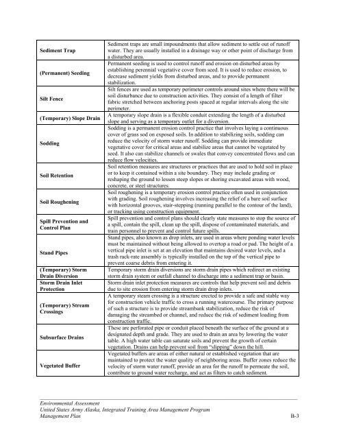
Sediment Trap(Permanent) SeedingSilt Fence(Temporary) Slope DrainSoddingSoil RetentionSoil RougheningSpill Prevention <strong>and</strong>Control PlanSt<strong>and</strong> Pipes(Temporary) StormDrain DiversionStorm Drain InletProtection(Temporary) StreamCrossingsSubsurface DrainsVegetated BufferSediment traps are small impoundments that allow sediment to settle out of runoffwater. They are usually installed in a drainage way or other point of discharge froma disturbed area.Permanent seeding is used to control runoff <strong>and</strong> erosion on disturbed areas byestablishing perennial vegetative cover from seed. It is used to reduce erosion, todecrease sediment yields from disturbed areas, <strong>and</strong> to provide permanentstabilization.Silt fences are used as temporary perimeter controls around sites where there will besoil disturbance due to construction activities. They consist of a length of filterfabric stretched between anchoring posts spaced at regular intervals along the siteperimeter.A temporary slope drain is a flexible conduit extending the length of a disturbedslope <strong>and</strong> serving as a temporary outlet for a diversion.Sodding is a permanent erosion control practice that involves laying a continuouscover of grass sod on exposed soils. In addition to stabilizing soils, sodding canreduce the velocity of storm water runoff. Sodding can provide immediatevegetative cover for critical areas <strong>and</strong> stabilize areas that cannot be vegetated byseed. It also can stabilize channels or swales that convey concentrated flows <strong>and</strong> canreduce flow velocities.Soil retention measures are structures or practices that are used to hold soil in placeor to keep it contained within a site boundary. They may include grading orreshaping the ground to lessen steep slopes or shoring excavated areas with wood,concrete, or steel structures.Soil roughening is a temporary erosion control practice often used in conjunctionwith grading. Soil roughening involves increasing the relief of a bare soil surfacewith horizontal grooves, stair-stepping (running parallel to the contour of the l<strong>and</strong>),or tracking using construction equipment.Spill prevention <strong>and</strong> control plans should clearly state measures to stop the source ofa spill, contain the spill, clean up the spill, dispose of contaminated materials, <strong>and</strong>train personnel to prevent <strong>and</strong> control future spills.St<strong>and</strong> pipes, also known as drop inlets, are used in areas where ponding water levelsmust be maintained without being allowed to overtop a road or pad. The height of avertical pipe inlet is set at an elevation that maintains desired water levels, <strong>and</strong> atrash rack-rate assembly is typically installed on the top of the vertical pipe toprevent coarse debris from entering it.Temporary storm drain diversions are storm drain pipes which redirect an existingstorm drain system or outfall channel to discharge into a sediment trap or basin.Storm drain inlet protection measures are controls that help prevent soil <strong>and</strong> debrisdue to site erosion from entering storm drain drop inlets.A temporary steam crossing is a structure erected to provide a safe <strong>and</strong> stable wayfor construction vehicle traffic to cross a running watercourse. The primary purposeof such a structure is to provide streambank stabilization, reduce the risk ofdamaging the streambed or channel, <strong>and</strong> reduce the risk of sediment loading fromconstruction traffic.These are perforated pipe or conduit placed beneath the surface of the ground at adesignated depth <strong>and</strong> grade. They are used to drain an area by lowering the watertable. A high water table can saturate soils <strong>and</strong> prevent the growth of certainvegetation. Drains can help prevent soil from “slipping” down the hill.Vegetated buffers are areas of either natural or established vegetation that aremaintained to protect the water quality of neighboring areas. Buffer zones reduce thevelocity of storm water runoff, provide an area for the runoff to permeate the soil,contribute to ground water recharge, <strong>and</strong> act as filters to catch sediment._____________________________________________________________________________________________Environmental AssessmentUnited States Army Alaska, <strong>Integrated</strong> <strong>Training</strong> <strong>Area</strong> <strong>Management</strong> Program<strong>Management</strong> Plan B-3
- Page 1:
DEPARTMENT OF THE ARMYUNITED STATES
- Page 5 and 6:
TABLE OF CONTENTSCHAPTER 1: PURPOSE
- Page 7 and 8:
Table 3.9 Summary of Impacts to Hum
- Page 9 and 10:
and Training Land Program, the rang
- Page 11 and 12:
• Establish a defined land condit
- Page 13:
Donnelly Training AreaDonnelly Trai
- Page 17 and 18:
determine whether additional NEPA a
- Page 19 and 20:
Table 2.2 Summary of Environmental
- Page 21 and 22:
CHAPTER 3: DESCRIPTION OF THE AFFEC
- Page 23 and 24:
Maneuver Trail Maintenance and Upgr
- Page 25 and 26:
Mungoven 2001). Engineering soil ty
- Page 27 and 28:
projects and would result in wide,
- Page 29 and 30:
growth. Wind and sand fences would
- Page 31 and 32:
iological impacts of military train
- Page 33 and 34:
willow scrub communities are common
- Page 35 and 36:
disturbed. Further, hardening low w
- Page 37 and 38:
disturbance or removal, best manage
- Page 39 and 40:
SRAThrough the SRA program, soldier
- Page 41 and 42:
Ship Creek (from the Glenn Highway
- Page 43 and 44:
effective site drainage. Required p
- Page 45 and 46:
Game 1998). More information on wil
- Page 47 and 48: Fort Wainwright and associated land
- Page 49 and 50: Long-term beneficial impacts to wil
- Page 51 and 52: 1998).The Alaska Interagency Wildla
- Page 53 and 54: Prescribed burns, mechanical thinni
- Page 55 and 56: unplanned fires, soldiers are direc
- Page 57 and 58: USARAK also implemented the USARTRA
- Page 59 and 60: LRAM projects beneficial to public
- Page 61 and 62: Cumulative ImpactsPast military act
- Page 63 and 64: Two surveys conducted on Yukon Trai
- Page 65 and 66: LRAM activities under Alternative 1
- Page 67 and 68: 3.9.1 Affected EnvironmentFort Rich
- Page 69 and 70: SRA program, which educates soldier
- Page 71 and 72: 3.10.2 Environmental ConsequencesAl
- Page 73 and 74: Fort Richardson receives few compla
- Page 75 and 76: Table 3.11 Summary of Impacts 1 to
- Page 77 and 78: oads and hauling fill and rock mate
- Page 79 and 80: CHAPTER 4: PREPARERS AND CONTRIBUTO
- Page 81 and 82: Benson, A.M. 1999. Distribution of
- Page 83 and 84: Neely, R. J. 2001. Early Mining His
- Page 85 and 86: CHAPTER 6: AGENCIES AND INDIVIDUALS
- Page 87 and 88: Project NameBulldog TrailWidening P
- Page 89 and 90: Project NameYukon TrainingArea Demo
- Page 91 and 92: Project NameYukon TrainingArea Firi
- Page 93 and 94: Project NameEddy Drop ZoneVegetatio
- Page 95 and 96: Project Name33 Mile LoopRoad Shortc
- Page 97: APPENDIX B: BEST MANAGEMENT PRACTIC
- Page 101 and 102: APPENDIX C: SAMPLE RECORD OF ENVIRO
- Page 103 and 104: APPENDIX D: ITAM PROJECT ASSESSMENT
- Page 105 and 106: Fire ManagementYes No□ □ Could
- Page 107 and 108: APPENDIX E: AGENCY COMMENTSThe foll
- Page 109 and 110: ___________________________________
- Page 111 and 112: ___________________________________
- Page 113 and 114: Sent: Monday, June 13, 2005 5:00 PM
- Page 115 and 116: Second paragraph - I do not underst
- Page 117 and 118: sentence could read, "The trees are
- Page 119 and 120: The third paragraph seems too speci
- Page 121: USARAK does not have a current five