Project NameBrigadier RoadUpgradeCharlie BatteryForwardOperations BaseYukon <strong>Training</strong><strong>Area</strong> ConvoyLive Fire RangePhase 1Yukon <strong>Training</strong><strong>Area</strong> ConvoyLive Fire RangePhase 2Digital Multi-Purpose <strong>Training</strong>Range/InfantryPlatoon BattleCourse ForwardOperations BasePhase 1Digital Multi-Purpose <strong>Training</strong>Range/InfantryPlatoon BattleCourse ForwardOperations BasePhase 2Digital Multi-Purpose <strong>Training</strong>Range/InfantryPlatoon BattleCourse ForwardOperations BasePhase 3Yukon <strong>Training</strong><strong>Area</strong> Firing Point11 UpgradeYukon <strong>Training</strong><strong>Area</strong> Firing Point12 UpgradeProject DescriptionThis project is located in the YTA <strong>and</strong> will improve a 1200 m section of existing road. This road is amajor access route for the eastern portion of the YTA <strong>and</strong> is characterized by a steep grade exceeding an18% slope, significant concentrated rill erosion <strong>and</strong> unsafe winter driving condition, including trackedvehicles. This project will re-establish a hardened road base with a maximum slope of 12% by installingre-routes, geotextile material <strong>and</strong> fill material <strong>and</strong> will improve access <strong>and</strong> erosion control throughgrading, ditching <strong>and</strong> the confinement of activity to hardened surfaces. In addition, this project willsignificantly improve safety during winter driving conditions.This project is located in the YTA adjacent to Johnson Road will improve a 4.5-acre section associatedwith FP Charlie by hardening a 30 m by 30 m pad <strong>and</strong> a 300 m access road <strong>and</strong> thinning a 2-acre tentarea. A latrine will be constructed on site along with several bermed areas for POL <strong>and</strong> maintenanceactivities. This project will improve access <strong>and</strong> control erosion by improving drainage through grading,establishing ditches, installing geotextile <strong>and</strong> fill material <strong>and</strong> confining activities to hardened surfaces.This project is located in the YTA adjacent to the Stuart Creek Impact <strong>Area</strong> <strong>and</strong> will upgrade a 4 kmsection of existing road by spot hardening, clearing lines of sight <strong>and</strong> installing 2 target objective areas.This area is characterized by steep slopes, rill erosion, poor drainage <strong>and</strong> rutting. This project willimprove access <strong>and</strong> control erosion by improving drainage through grading, establishing ditches,installing geotextile <strong>and</strong> fill material <strong>and</strong> confining activities to hardened surfaces.This project is located in the YTA adjacent to the Stuart Creek Impact <strong>Area</strong> <strong>and</strong> will upgrade a 4 kmsection of existing road by spot hardening, clearing lines of sight <strong>and</strong> installing 3 target objective areas.This area is characterized by steep slopes, rill erosion, poor drainage <strong>and</strong> rutting. This project exp<strong>and</strong>supgrades made in Convoy Live Fire Range Phase 1 <strong>and</strong> will improve access <strong>and</strong> control erosion byimproving drainage through grading, establishing ditches, installing geotextile <strong>and</strong> fill material <strong>and</strong>confining activities to hardened surfaces.This project is located in the YTA within an area formally known as Lower Winter Camp. This projectwill include initial road/pad base hardening of a 500 m by 10 m access trail <strong>and</strong> a 150 m by 150 m pad.The DMPTR/IPBC FOB will exp<strong>and</strong> upgrades made on previous Lower Winter Camp projects <strong>and</strong> willsupport bivouac activities associated with the DMPTR <strong>and</strong> IPBC Ranges. This project will improveaccess <strong>and</strong> control erosion by improving drainage through grading, establishing ditches, installinggeotextile <strong>and</strong> fill material <strong>and</strong> confining activities to hardened surfaces.This project is located in the YTA within an area formally known as Lower Winter Camp. This projectwill exp<strong>and</strong> upgrades from DMPTR/IPBC Fob Phase 1 by installing an intermediate cap on a 500 m by10 m access trail <strong>and</strong> a 150 m by 150 m pad. This project will improve access <strong>and</strong> control erosion byimproving drainage through grading, establishing ditches, installing geotextile <strong>and</strong> fill material <strong>and</strong>confining activities to hardened surfaces.This project is located in the YTA within an area formally known as Lower Winter Camp. This projectwill complete upgrades from DMPTR/IPBC Fob Phase 1 <strong>and</strong> 2 by installing a final cap on a 500 m by 10m access trail <strong>and</strong> a 150m by 150m pad. This project will improve access <strong>and</strong> control erosion byimproving drainage through grading, establishing ditches, installing geotextile <strong>and</strong> fill material <strong>and</strong>confining activities to hardened surfaces.This project is located in the YTA TA 7 <strong>and</strong> will improve an existing firing point that is no longer inuseable condition. This project will upgrade approximately 2.5 acres by clearing vegetation <strong>and</strong> hardeninga 100 m by 100 m pad <strong>and</strong> a 100 m by 10 m access road. This project will improve access <strong>and</strong> controlerosion by improving drainage through grading, establishing ditches, installing geotextile <strong>and</strong> fill material<strong>and</strong> confining activities to hardened surfaces.This project is located in the YTA Stuart Creek Impact <strong>Area</strong> <strong>and</strong> will improve an existing firing point thatis no longer in useable condition. This project will upgrade approximately 2.5 acres by clearingvegetation <strong>and</strong> hardening a 100 m by 100 m pad <strong>and</strong> a 100 m by 10 m access road. This project willimprove access <strong>and</strong> control erosion by improving drainage through grading, establishing ditches,installing geotextile <strong>and</strong> fill material <strong>and</strong> confining activities to hardened surfaces.ApproximateAcresImpacted34.59.910.16.86.86.82.52.5_____________________________________________________________________________________________Environmental AssessmentUnited States Army Alaska, <strong>Integrated</strong> <strong>Training</strong> <strong>Area</strong> <strong>Management</strong> Program<strong>Management</strong> Plan A-5
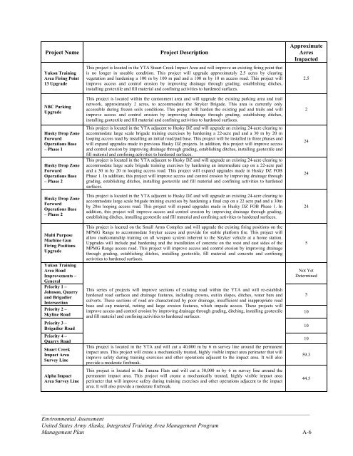
Project NameYukon <strong>Training</strong><strong>Area</strong> Firing Point13 UpgradeNBC ParkingUpgradeHusky Drop ZoneForwardOperations Base– Phase 1Husky Drop ZoneForwardOperations Base– Phase 2Husky Drop ZoneForwardOperations Base– Phase 2Multi PurposeMachine GunFiring PositionsUpgradeYukon <strong>Training</strong><strong>Area</strong> RoadImprovements –GeneralPriority 1 –Johnson, Quarry<strong>and</strong> BrigadierIntersectionPriority 2 –Skyline RoadPriority 3 –Brigadier RoadPriority 4 –Quarry RoadStuart CreekImpact <strong>Area</strong>Survey LineAlpha Impact<strong>Area</strong> Survey LineProject DescriptionThis project is located in the YTA Stuart Creek Impact <strong>Area</strong> <strong>and</strong> will improve an existing firing point thatis no longer in useable condition. This project will upgrade approximately 2.5 acres by clearingvegetation <strong>and</strong> hardening a 100 m by 100 m pad <strong>and</strong> a 100 m by 10 m access road. This project willimprove access <strong>and</strong> control erosion by improving drainage through grading, establishing ditches,installing geotextile <strong>and</strong> fill material <strong>and</strong> confining activities to hardened surfaces.This project is located within the cantonment area <strong>and</strong> will upgrade the existing parking area <strong>and</strong> trailnetwork, approximately 2 acres, to accommodate the Stryker Brigade. This area is currently onlyaccessible during frozen soils conditions. This project will harden the existing pad <strong>and</strong> trails <strong>and</strong> willimprove access <strong>and</strong> control erosion by improving drainage through grading, establishing ditches,installing geotextile <strong>and</strong> fill material <strong>and</strong> confining activities to hardened surfaces.This project is located in the YTA adjacent to Husky DZ <strong>and</strong> will upgrade an existing 24-acre clearing toaccommodate large scale brigade training exercises by hardening a 22-acre pad <strong>and</strong> a 30 m by 20 mlooping access road by installing an initial road/pad base. This project will be installed in three phases <strong>and</strong>will exp<strong>and</strong> upgrades made in previous Husky DZ projects. In addition, this project will improve access<strong>and</strong> control erosion by improving drainage through grading, establishing ditches, installing geotextile <strong>and</strong>fill material <strong>and</strong> confining activities to hardened surfaces.This project is located in the YTA adjacent to Husky DZ <strong>and</strong> will upgrade an existing 24-acre clearing toaccommodate large scale brigade training exercises by hardening an intermediate cap on a 22-acre pad<strong>and</strong> a 30 m by 20 m looping access road. This project will exp<strong>and</strong> upgrades made in Husky DZ FOBPhase 1. In addition, this project will improve access <strong>and</strong> control erosion by improving drainage throughgrading, establishing ditches, installing geotextile <strong>and</strong> fill material <strong>and</strong> confining activities to hardenedsurfaces.This project is located in the YTA adjacent to Husky DZ <strong>and</strong> will upgrade an existing 24-acre clearing toaccommodate large scale brigade training exercises by hardening a final cap on a 22 acre pad <strong>and</strong> a 30mby 20m looping access road. This project will exp<strong>and</strong> upgrades made in Husky DZ FOB Phase 1. Inaddition, this project will improve access <strong>and</strong> control erosion by improving drainage through grading,establishing ditches, installing geotextile <strong>and</strong> fill material <strong>and</strong> confining activities to hardened surfaces.This project is located on the Small Arms Complex <strong>and</strong> will upgrade the existing firing positions on theMPMG Range to accommodate Stryker access <strong>and</strong> provide for stable platform fire. This project willallow marksmanship training on all weapon system inherent to the Stryker vehicle at a home station.Upgrades will include pad hardening <strong>and</strong> the installation of concrete on the west <strong>and</strong> east sides of theMPMG Range access road. This project will improve access <strong>and</strong> control erosion by improving drainagethrough grading, establishing ditches, installing geotextile, fill material <strong>and</strong> concrete <strong>and</strong> confiningactivities to hardened surfaces.This series of projects will improve sections of existing road within the YTA <strong>and</strong> will re-establishhardened road surfaces <strong>and</strong> drainage features, including crowns, out/in slopes, ditches, water bars <strong>and</strong>culverts. These sections of road are characterized by poor drainage, insufficient <strong>and</strong> inappropriate roadbase <strong>and</strong> cap material, rutting <strong>and</strong> large erosion features, which impede access. These projects willimprove access <strong>and</strong> control erosion by improving drainage through grading, ditching, installing geotextile<strong>and</strong> fill material <strong>and</strong> confining activities to hardened surfaces.This project is located in the YTA <strong>and</strong> will cut a 40,000 m by 6 m survey line around the permanentimpact area. This project will create a mechanically treated, highly visible impact area perimeter that willimprove safety during training exercises <strong>and</strong> other operations adjacent to the impact area. It will alsoprovide a moderate firebreak.This project is located in the Tanana Flats <strong>and</strong> will cut a 30,000 m by 6 m survey line around thepermanent impact area. This project will create a mechanically treated, highly visible impact areaperimeter that will improve safety during training exercises <strong>and</strong> other operations adjacent to the impactarea. It will also provide a moderate firebreak.ApproximateAcresImpacted2.522424245Not YetDetermined510101059.344.5_____________________________________________________________________________________________Environmental AssessmentUnited States Army Alaska, <strong>Integrated</strong> <strong>Training</strong> <strong>Area</strong> <strong>Management</strong> Program<strong>Management</strong> Plan A-6
- Page 1:
DEPARTMENT OF THE ARMYUNITED STATES
- Page 5 and 6:
TABLE OF CONTENTSCHAPTER 1: PURPOSE
- Page 7 and 8:
Table 3.9 Summary of Impacts to Hum
- Page 9 and 10:
and Training Land Program, the rang
- Page 11 and 12:
• Establish a defined land condit
- Page 13:
Donnelly Training AreaDonnelly Trai
- Page 17 and 18:
determine whether additional NEPA a
- Page 19 and 20:
Table 2.2 Summary of Environmental
- Page 21 and 22:
CHAPTER 3: DESCRIPTION OF THE AFFEC
- Page 23 and 24:
Maneuver Trail Maintenance and Upgr
- Page 25 and 26:
Mungoven 2001). Engineering soil ty
- Page 27 and 28:
projects and would result in wide,
- Page 29 and 30:
growth. Wind and sand fences would
- Page 31 and 32:
iological impacts of military train
- Page 33 and 34:
willow scrub communities are common
- Page 35 and 36:
disturbed. Further, hardening low w
- Page 37 and 38:
disturbance or removal, best manage
- Page 39 and 40: SRAThrough the SRA program, soldier
- Page 41 and 42: Ship Creek (from the Glenn Highway
- Page 43 and 44: effective site drainage. Required p
- Page 45 and 46: Game 1998). More information on wil
- Page 47 and 48: Fort Wainwright and associated land
- Page 49 and 50: Long-term beneficial impacts to wil
- Page 51 and 52: 1998).The Alaska Interagency Wildla
- Page 53 and 54: Prescribed burns, mechanical thinni
- Page 55 and 56: unplanned fires, soldiers are direc
- Page 57 and 58: USARAK also implemented the USARTRA
- Page 59 and 60: LRAM projects beneficial to public
- Page 61 and 62: Cumulative ImpactsPast military act
- Page 63 and 64: Two surveys conducted on Yukon Trai
- Page 65 and 66: LRAM activities under Alternative 1
- Page 67 and 68: 3.9.1 Affected EnvironmentFort Rich
- Page 69 and 70: SRA program, which educates soldier
- Page 71 and 72: 3.10.2 Environmental ConsequencesAl
- Page 73 and 74: Fort Richardson receives few compla
- Page 75 and 76: Table 3.11 Summary of Impacts 1 to
- Page 77 and 78: oads and hauling fill and rock mate
- Page 79 and 80: CHAPTER 4: PREPARERS AND CONTRIBUTO
- Page 81 and 82: Benson, A.M. 1999. Distribution of
- Page 83 and 84: Neely, R. J. 2001. Early Mining His
- Page 85 and 86: CHAPTER 6: AGENCIES AND INDIVIDUALS
- Page 87 and 88: Project NameBulldog TrailWidening P
- Page 89: Project NameYukon TrainingArea Demo
- Page 93 and 94: Project NameEddy Drop ZoneVegetatio
- Page 95 and 96: Project Name33 Mile LoopRoad Shortc
- Page 97 and 98: APPENDIX B: BEST MANAGEMENT PRACTIC
- Page 99 and 100: Sediment Trap(Permanent) SeedingSil
- Page 101 and 102: APPENDIX C: SAMPLE RECORD OF ENVIRO
- Page 103 and 104: APPENDIX D: ITAM PROJECT ASSESSMENT
- Page 105 and 106: Fire ManagementYes No□ □ Could
- Page 107 and 108: APPENDIX E: AGENCY COMMENTSThe foll
- Page 109 and 110: ___________________________________
- Page 111 and 112: ___________________________________
- Page 113 and 114: Sent: Monday, June 13, 2005 5:00 PM
- Page 115 and 116: Second paragraph - I do not underst
- Page 117 and 118: sentence could read, "The trees are
- Page 119 and 120: The third paragraph seems too speci
- Page 121: USARAK does not have a current five