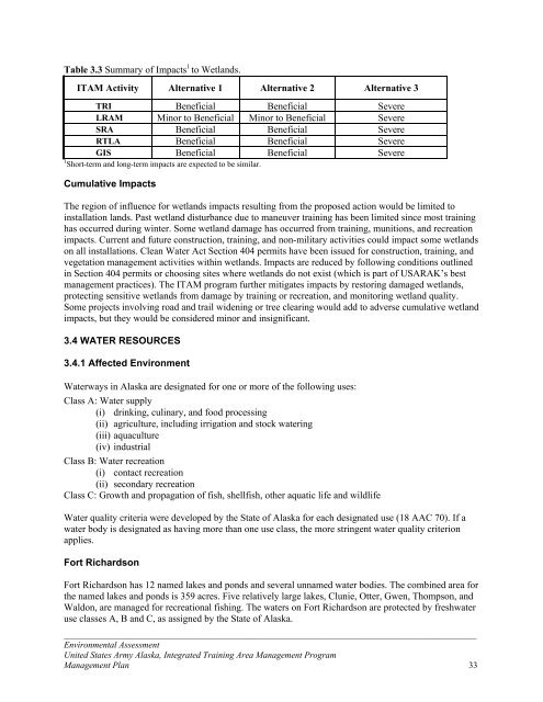
Table 3.3 Summary of Impacts 1 to Wetl<strong>and</strong>s.ITAM Activity Alternative 1 Alternative 2 Alternative 3TRI Beneficial Beneficial SevereLRAM Minor to Beneficial Minor to Beneficial SevereSRA Beneficial Beneficial SevereRTLA Beneficial Beneficial SevereGIS Beneficial Beneficial Severe1 Short-term <strong>and</strong> long-term impacts are expected to be similar.Cumulative ImpactsThe region of influence for wetl<strong>and</strong>s impacts resulting from the proposed action would be limited toinstallation l<strong>and</strong>s. Past wetl<strong>and</strong> disturbance due to maneuver training has been limited since most traininghas occurred during winter. Some wetl<strong>and</strong> damage has occurred from training, munitions, <strong>and</strong> recreationimpacts. Current <strong>and</strong> future construction, training, <strong>and</strong> non-military activities could impact some wetl<strong>and</strong>son all installations. Clean Water Act Section 404 permits have been issued for construction, training, <strong>and</strong>vegetation management activities within wetl<strong>and</strong>s. Impacts are reduced by following conditions outlinedin Section 404 permits or choosing sites where wetl<strong>and</strong>s do not exist (which is part of USARAK’s bestmanagement practices). The ITAM program further mitigates impacts by restoring damaged wetl<strong>and</strong>s,protecting sensitive wetl<strong>and</strong>s from damage by training or recreation, <strong>and</strong> monitoring wetl<strong>and</strong> quality.Some projects involving road <strong>and</strong> trail widening or tree clearing would add to adverse cumulative wetl<strong>and</strong>impacts, but they would be considered minor <strong>and</strong> insignificant.3.4 WATER RESOURCES3.4.1 Affected EnvironmentWaterways in Alaska are designated for one or more of the following uses:Class A: Water supply(i) drinking, culinary, <strong>and</strong> food processing(ii) agriculture, including irrigation <strong>and</strong> stock watering(iii) aquaculture(iv) industrialClass B: Water recreation(i) contact recreation(ii) secondary recreationClass C: Growth <strong>and</strong> propagation of fish, shellfish, other aquatic life <strong>and</strong> wildlifeWater quality criteria were developed by the State of Alaska for each designated use (18 AAC 70). If awater body is designated as having more than one use class, the more stringent water quality criterionapplies.Fort RichardsonFort Richardson has 12 named lakes <strong>and</strong> ponds <strong>and</strong> several unnamed water bodies. The combined area forthe named lakes <strong>and</strong> ponds is 359 acres. Five relatively large lakes, Clunie, Otter, Gwen, Thompson, <strong>and</strong>Waldon, are managed for recreational fishing. The waters on Fort Richardson are protected by freshwateruse classes A, B <strong>and</strong> C, as assigned by the State of Alaska._____________________________________________________________________________________________Environmental AssessmentUnited States Army Alaska, <strong>Integrated</strong> <strong>Training</strong> <strong>Area</strong> <strong>Management</strong> Program<strong>Management</strong> Plan 33
Ship Creek (from the Glenn Highway bridge to the mouth) is listed on the state’s 303 (d) list of impairedwaters due to excess fecal coliform bacteria, petroleum hydrocarbon, oil, <strong>and</strong> grease. A total maximumdaily load for fecal coliform has been determined. According to Alaska Department of EnvironmentalConservation studies, most of the pollutants entered Ship Creek as non-point sources from surface waterrunoff <strong>and</strong> groundwater downstream of the post, where the watershed is increasingly urbanized. Aftercompiling <strong>and</strong> reviewing the data, the state concluded that no cumulative or increasing water qualitydegradation was occurring in the lower portion of Ship Creek (ADEC 1996). Water from Ship Creek isdiverted for Fort Richardson, Elmendorf Air Force Base, <strong>and</strong> the Anchorage Municipality. Ship Creekleaves Fort Richardson at the border with Elmendorf Air Force Base.Eagle River is a glacial waterway that ends at Eagle River Flats, a 2,200-acre estuarine tidal marsh. EagleRiver Flats was removed from the state’s list of impaired waters after extensive remediation efforts forwhite phosphorous were shown to be successful (ADEC 2002).Industrial activities have had some effects on groundwater. Through monitoring, pollution was found tobe associated with underground storage tanks, chemical storage facilities, <strong>and</strong> chemical dumpsites. FortRichardson was identified as a CERCLA (Superfund) site. These areas are monitored intensively <strong>and</strong> noindication of deep groundwater pollution has been detected. Pollution has been minor <strong>and</strong> localized <strong>and</strong>no significant risks to human health were found. Water quality has improved recently due to Armyrestoration projects to mitigate previous damage to the groundwater quality (USARAK 2004).Fort WainwrightOverall surface water quality on Fort Wainwright is good. The Chena River has been designated for ClassA, B, <strong>and</strong> C uses. Iron concentrations, which stem from natural sources, exceed state secondary waterst<strong>and</strong>ards. The Chena River portion that runs through Fairbanks <strong>and</strong> Fort Wainwright is listed on thestate’s 303 (d) list for impaired waters. The pollutants of concern are petroleum, hydrocarbons, <strong>and</strong>sediment. The pollutant source is listed as urban runoff. A total maximum daily load for petroleum <strong>and</strong>hydrocarbons is expected this year (2005).Due to its remote location, surface water quality data are not collected for much of Tanana Flats <strong>Training</strong><strong>Area</strong>. Data for the Wood <strong>and</strong> Tanana rivers upstream <strong>and</strong> downstream of the training area are used toestimate water quality. However, since these streams are surface-water <strong>and</strong> spring-fed (not glacier-fed) itis expected that water quality would differ greatly between these rivers <strong>and</strong> the streams originating withinthe training area.Due to lack of human development <strong>and</strong> activity on the training area, surface waters on Yukon <strong>Training</strong><strong>Area</strong> are relatively pristine. Water bodies originating within Yukon <strong>Training</strong> <strong>Area</strong> flow into the ChenaRiver. The waters meet all primary drinking water st<strong>and</strong>ards, <strong>and</strong> iron is the only parameter to exceed theAlaska state secondary drinking water st<strong>and</strong>ards. All of Yukon <strong>Training</strong> <strong>Area</strong>’s surface waters have lowrates of primary <strong>and</strong> secondary productivity <strong>and</strong> high water quality.Groundwater in the Fort Wainwright area contains high levels of metals, especially iron. Elevated arseniclevels are prevalent in the upl<strong>and</strong> areas. These are naturally occurring levels <strong>and</strong> are not related to humancausedpollution (U.S. Army Corps of Engineers 1994).Industrial activity on Main Post has caused groundwater pollution associated with underground storagetanks, chemical storage facilities, <strong>and</strong> chemical dumpsites. These areas were identified <strong>and</strong> are monitoredintensively. Pollution at the sites is localized, <strong>and</strong> monitoring indicates no deep groundwater pollution._____________________________________________________________________________________________Environmental AssessmentUnited States Army Alaska, <strong>Integrated</strong> <strong>Training</strong> <strong>Area</strong> <strong>Management</strong> Program<strong>Management</strong> Plan 34
- Page 1: DEPARTMENT OF THE ARMYUNITED STATES
- Page 5 and 6: TABLE OF CONTENTSCHAPTER 1: PURPOSE
- Page 7 and 8: Table 3.9 Summary of Impacts to Hum
- Page 9 and 10: and Training Land Program, the rang
- Page 11 and 12: • Establish a defined land condit
- Page 13: Donnelly Training AreaDonnelly Trai
- Page 17 and 18: determine whether additional NEPA a
- Page 19 and 20: Table 2.2 Summary of Environmental
- Page 21 and 22: CHAPTER 3: DESCRIPTION OF THE AFFEC
- Page 23 and 24: Maneuver Trail Maintenance and Upgr
- Page 25 and 26: Mungoven 2001). Engineering soil ty
- Page 27 and 28: projects and would result in wide,
- Page 29 and 30: growth. Wind and sand fences would
- Page 31 and 32: iological impacts of military train
- Page 33 and 34: willow scrub communities are common
- Page 35 and 36: disturbed. Further, hardening low w
- Page 37 and 38: disturbance or removal, best manage
- Page 39: SRAThrough the SRA program, soldier
- Page 43 and 44: effective site drainage. Required p
- Page 45 and 46: Game 1998). More information on wil
- Page 47 and 48: Fort Wainwright and associated land
- Page 49 and 50: Long-term beneficial impacts to wil
- Page 51 and 52: 1998).The Alaska Interagency Wildla
- Page 53 and 54: Prescribed burns, mechanical thinni
- Page 55 and 56: unplanned fires, soldiers are direc
- Page 57 and 58: USARAK also implemented the USARTRA
- Page 59 and 60: LRAM projects beneficial to public
- Page 61 and 62: Cumulative ImpactsPast military act
- Page 63 and 64: Two surveys conducted on Yukon Trai
- Page 65 and 66: LRAM activities under Alternative 1
- Page 67 and 68: 3.9.1 Affected EnvironmentFort Rich
- Page 69 and 70: SRA program, which educates soldier
- Page 71 and 72: 3.10.2 Environmental ConsequencesAl
- Page 73 and 74: Fort Richardson receives few compla
- Page 75 and 76: Table 3.11 Summary of Impacts 1 to
- Page 77 and 78: oads and hauling fill and rock mate
- Page 79 and 80: CHAPTER 4: PREPARERS AND CONTRIBUTO
- Page 81 and 82: Benson, A.M. 1999. Distribution of
- Page 83 and 84: Neely, R. J. 2001. Early Mining His
- Page 85 and 86: CHAPTER 6: AGENCIES AND INDIVIDUALS
- Page 87 and 88: Project NameBulldog TrailWidening P
- Page 89 and 90: Project NameYukon TrainingArea Demo
- Page 91 and 92:
Project NameYukon TrainingArea Firi
- Page 93 and 94:
Project NameEddy Drop ZoneVegetatio
- Page 95 and 96:
Project Name33 Mile LoopRoad Shortc
- Page 97 and 98:
APPENDIX B: BEST MANAGEMENT PRACTIC
- Page 99 and 100:
Sediment Trap(Permanent) SeedingSil
- Page 101 and 102:
APPENDIX C: SAMPLE RECORD OF ENVIRO
- Page 103 and 104:
APPENDIX D: ITAM PROJECT ASSESSMENT
- Page 105 and 106:
Fire ManagementYes No□ □ Could
- Page 107 and 108:
APPENDIX E: AGENCY COMMENTSThe foll
- Page 109 and 110:
___________________________________
- Page 111 and 112:
___________________________________
- Page 113 and 114:
Sent: Monday, June 13, 2005 5:00 PM
- Page 115 and 116:
Second paragraph - I do not underst
- Page 117 and 118:
sentence could read, "The trees are
- Page 119 and 120:
The third paragraph seems too speci
- Page 121:
USARAK does not have a current five