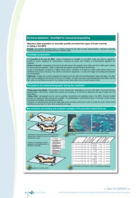
Technical datasheet - Overflight for manual photographingObjective: Data acquisition to manually quantify and determine types of boats mooringor sailing in the <strong>MPA</strong>.Remark : the method described below is entirely manual for the sake of easy implementation. High-tech automaticmethods developed by specialized firms do, however, exist.Overflight preparationIs it possible to fly over the <strong>MPA</strong> : before considering an overflight of your <strong>MPA</strong>, make sure that no regulationsprohibit or control (applying for authorisation) overflying the study zone (military or environmental regulation forexample).Choice of aircraft : irrespective of the kind of aircraft chosen, the operator must make sure that it offers good visibilityfor taking aerial photographs. ULMs or high-wing monoplanes should therefore be preferred.Choice of photography equipment: a digital camera with a resolution of at least six million pixels allows boats to beidentified during post-processing. The camera must also be responsive, i.e. with short trigger and waiting time betweentwo photographs.Flight plan : a flight plan must be prepared and approved by the pilot and the photographer before the flight. The flightplan must be adapted to the site and to the aim of the flight. The plan must also avoid photographs being taken into thelight, allow an identifiable land part to be included in each wide-angle shot and avoid double counts.Precautions for aerial photographs during the overflightFlying speed and altitude : flying speed must be reduced and, depending on the aim of the flight, the aircraft will fly atapproximately 1,000 feet for simple boat counting and locating or at 500 feet to determine the type of boats from theshots taken.Taking shots : photographs can be used to quantify, characterise and spatialise boats in the <strong>MPA</strong>. Several hundredpictures can rapidly be taken during one overflight. The photographer must therefore bear in mind that a small numberof pictures will facilitate manual post-processing.Therefore, the photographer will opt for wide-angle shots including a land part in order to locate the photo. Boats will beidentified by zooming in on them when analysing the image.Manual photo processing and analysis: example of Porquerolles Island (France)1Porquerolles IslandN0 1 Km1 234Delimitation and coding of the <strong>MPA</strong>'s mooring orsailing areas. Boats can then be counted andidentified by sector. LongueurCreation of a typology of boatsadapted to the characteristics ofthe fleet in the <strong>MPA</strong>.4Mapping by mooring sector.CodeCode1 Vedette habitable 1 < 6m2 Vedette non habitable 23 Pneumatique3 10 à 15m4 Voilier habitable4 15 à 20m5 Voilier non habitable 5 >20m6789N0 1 KmN0 1 KmJet-skiBateau de plongée...indéterminé2Counting, characterisation and location of boats using obliqueaerial views.3N°dateheuretype_comptagecode secteurtype bateaulongueur bateauxnombre bateauxvedette mot.habitable 1 samedi, août 13, 2011 14h00 survol 25115-20m 2 beau tempsvedette mot.habitable 10-15m 2 beau temps2 samedi, août 13, 2011 14h00 survol 251vedette mot.habitable moins 10m 5 beau temps3 samedi, août 13, 2011 14h00 survol 251voilierhabitable 15-20m 2 beau temps4 samedi, août 13, 2011 14h00 survol 2515 samedi, août 13, 2011 14h00 survol 251 pneumatique moins 10m 2 beau temps6 samedi, août 13, 2011 14h00 survolvoilier251 habitable 10-15m 1 beau temps7 samedi, août 13, 2011 14h00 survolvoilier261 habitable 10-15m 4 beau temps8 samedi, août 13, 2011 14h00 survolvedette mot.261 habitable 10-15m 1 beau temps9 samedi, août 13, 2011 14h00 survolvedettemoteur non261 habitable moins 10m 1 beau tempsInformation archiving in a GIS or spreadsheet database.météo TABLE OF CONTENTS 50 COLLECTION VISITOR USE OBSERVATION AND MONITORING IN MEDITERRANEAN MARINE PROTECTED AREAS
BibliographyAudouit C., 2009 - L'étude de la fréquentation et de sesimpacts sur le littoral languedocien. Thèse de Géographie,Université de Montpellier III, Montpellier, 557 p.Brigand L., Le Berre S., 2007- Joint construction and appropriationof indicators by the users, the managers and thescientists: the example of the touristic frequentation observatoryof Port-Cros and Porquerolles. International Journal ofSustainable Development, 10, 1 et 2, pp. 139-160.Brigand L., Retière D., Richez G., 2003 - Étude de la fréquentationtouristique des îles de Port-Cros et Porquerolles.Rapport Parc national de Port-Cros, Université de BretagneOccidentale, Université de Provence, 100 p.Brown, G., Koth B., Kreag G., Weber D., 2006 - ManagingAustralia's protected areas: review of <strong>visitor</strong> managementmodels, frameworks and processes. CRC for SustainableTourism, Gold Coast, Qld., 98 p.Cessford, G. & Muhar, A., 2003 - <strong>Monitoring</strong> options for numbersin national parks and protected areas. Journal of NatureConservation, n° 11, pp. 240-250.Dalias N., Lenfant P., Licari M.L., Bardelletti C., 2007 - Guided’aide à la gestion des Aires Marines Protégées : gestion etsuivi de l’activité de plongée sous-marine. Document édité parle Conseil Général des Pyrénées-Orientales dans le cadre duprogramme Interreg IIIC MEDPAN. Contrat Conseil Général desPyrénées- Orientales - EPHE - OCEANIDE. 62 pages + annexesEagles P.F.J., McCool S. F. ; Haynes C.D., 2002 - Sustainabletourism in Protected Areas. Guidelines for planning and management.IUCN Gland, Switzerland and Cambridge, UK, 183 p.Eco-Compteur - Conseils techniques et dispositifs de comptage: http://www.eco-compteur.comFoulquié M., Blouet S., Chéré E., Dupuy de la Grandrive R.,Fabre E., Dalias N., 2012 - Restauration naturelle des populationsde gorgones blanches Eunicella singularis (Esper, 1794)après installation d’ancrages écologiques Harmony, sur le sitede plongée des Tables. Site Natura 2000 « Posidonies du Capd’Agde » FR-9101414. ADENA , SEANEO 91 p.Jollit I., 2010 - Spatialisation des activités humaines et aideà la décision pour une gestion durable des écosystèmescoralliens. La pêche plaisancière dans le lagon sud-ouest dela Nouvelle-Calédonie. Thèse de doctorat en Géographie,Université de la Nouvelle-Calédonie, 558 p.Le Berre S., Brigand L., Morio A., Maurer C., 2010 - Bountîles.Un outil pour une meilleure gestion de la fréquentation.A Port-Cros, l’observatoire est aussi un outil de concertation.Espaces, 278, pp. 17-21.Le Berre S., 2008 - Les observatoires de la fréquentation, outilsd’aide à la gestion des îles et des littoraux. Brest, thèse deGéographie, Géomer LETG UMR 6554 CNRS, UBO, 745 p.Le Berre S., Brigand L., 2004 - Bountîles Port-Cros (Based’observation des usages nautiques et terrestre des îles).Méthode de suivi de la fréquentation touristique à terre et enmer. Recueil méthodologique. LETG Brest - Géomer, Universitéde Bretagne Occidentale, Brest, 36 p.Le Corre N., Le Berre S., Brigand L., Peuziat I., 2012 -« Comment étudier et suivre la fréquentation dans les espaceslittoraux, marins et insulaires ? De l'état de l'art à une visionprospective de la recherche », EchoGéo, 19 | 2012, mis enligne le 10 février 2012, http://echogeo.revues.org/12749 ;DOI : 10.4000/echogeo.12749Le Corre, N., Le Berre, S., Meunier, Brigand, L., M., Boncoeur,J., Alban, F., 2011 - Dispositifs de suivi de la fréquentation desespaces marins, littoraux et insulaires et de ses retombéessocioéconomiques : état de l’art. Rapport Géomer LETG,UMR 6554 et UMR M101 Amure, Université de BretagneOccidentale, Agence des Aires Marines Protégées, 150 p.Goeldner-Gianella L., Humain-Lamoure A.-L., 2010 - Lesenquêtes par questionnaire en géographie de l’environnement.L’Espace Géographique, 4, pp. 325-344.Griffin, T., et al., 2010 - Protected area management : collectionand use of <strong>visitor</strong> data: Vol. 1, summary and recommendations.CRC for Sustainable Tourism, Gold Coast, Qld., 50 p.Hornback, K.E., Eagles, P.FJ., 1999 - Guidelines for publicuse measurement and reporting at parks and protected areas.IUCN, Gland, Switzerland and Cambridge, UK, 90 p.Kajala, L., Almik, A., Dahl, R., Dikšaite, L, Erkkonen, J., Fredman,P., Jensen, F. Søndergaard, Karoles, K., Sievänen, T.,Skov-Petersen, H., Vistad, O. I. and Wallsten, P. 2007 - Visitormonitoring in nature areas - a manual based on experiencesfrom the Nordic and Baltic countries, Swedish EnvironmentalProtection Agency, 198 p. http://www.eceat-projects.org/tourism-manual/2-10 Visitor <strong>Monitoring</strong> in Nature areas.pdfMelville S., Ruohonen J., 2004 - The development of aremote-download system for <strong>visitor</strong> counting. Working Papersof the Finnish Forest Research Institute 2, pp. 38-44.Muhar A. et al., 2002 - Methods for Visitor <strong>Monitoring</strong> inRecreational and Protected Areas: An Overview. <strong>Monitoring</strong>and Management of Visitor Flows in Recreational and ProtectedAreas. Conference Proceedings, 6 p.Musard O., 2003 - Les pratiques subaquatiques au sein desaires marines protégées de Méditerranée française : entrepaysages sous-marins, représentations et impacts. Contributionau développement d’une géographie relative auxterritoires sous-marin. Thèse de géographie (sous la dir. de G.Richez), Université d’Aix-Marseille 1, Maison Méditerranéennedes Sciences de l’Homme, Aix-en-provence, 449 p.Muñoz N., 2007 - Utilisation de l’espace et comportement desplongeurs aux îles Medes, étude de terrain. Rapport MedPAN,137 p.Peuziat I., 2005 - Plaisance et environnement. Pratiques,représentations et impacts de la fréquentation nautique de loisirdans les espaces insulaires. Le cas de l’archipel de Glénan(France), Thèse de Doctorat en Géographie, Géomer UMR6554-FR 2195, UBO, IUEM, Brest, 336 p.Scottish natural Heritage, Visitor monitoring manual,http://archive.snh.gov.uk/vmm/aims.html TABLE OF CONTENTS 51 COLLECTION VISITOR USE OBSERVATION AND MONITORING IN MEDITERRANEAN MARINE PROTECTED AREAS