Detailed Soil Survey of the Mount Revelstoke Summit Area.
Detailed Soil Survey of the Mount Revelstoke Summit Area. Detailed Soil Survey of the Mount Revelstoke Summit Area.
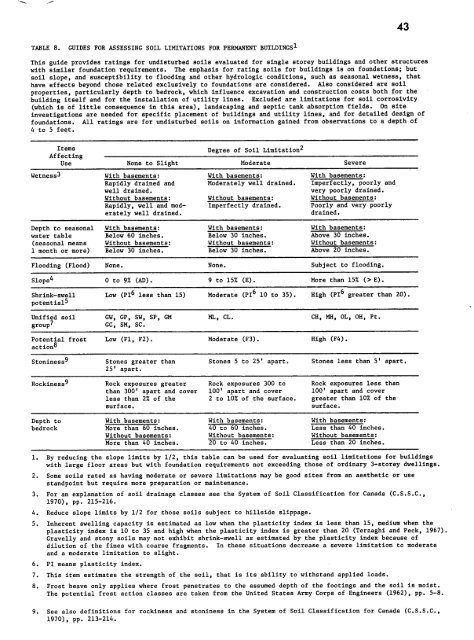
43TABLE 8 .GUIDES FOR ASSESSING SOIL LIMITATIONS FOR PERMANENT BUILDINGS'This guide provides ratings for undisturbed soils evaluated for single storey buildings and other structureswith similar foundation requirements . The emphasis for rating soils for buildings is on foundations ; butsoil slope, and susceptibility to flooding and other hydrologic conditions, such as seasonal wetness, thathave effects beyond those related exclusively to foundations are considered . Also considered are soilproperties, particularly depth to bedrock, which influence excavation and construction costs both for thebuilding itself and for the installation of utility lines . Excluded are limitations for soil corrosivity(which is of little consequence in this area), landscaping and septic tank absorption fields . On siteinvestigations are needed for specific placement of buildings and utility lines, and for detailed design offoundations . All ratings are for undisturbed soils on information gained from observations to a depth of4 to 5 feet .ItemsAffectingUseone to SlightDegree of Soil Limitation2oderateevereWetness3 With basements : With basements: With basements :Rapidly drained and Moderately well drained . Imperfectly, poorly andwell drained . very poorly drained .Without basements : Without basements : Without basements :Rapidly, well and mod- Imperfectly drained . Poorly and very poorlyerately well drained . drained .Depth to seasonal With basements : With basements: With basements :water table Below 60 inches . Below 30 inches . Above 30 inches .(seasonal means Without basements : Without basements : Without basements :1 month or more) Below 30 inches . Below 30 inches . Above 20 inches .Flooding (Flood) None . None . Subject to flooding .Slope4 0 to 9% (AD) . 9 to 15% (E) . More than 157 (> E) .Shrink-swell Low (PI6 less than 15) Moderate (PI6 10 to 35) . High (PI6 greater than 20) .potential5Unified soil GW, GP, SW, SP, GM ML, CL . CH, MH, OL, OH, Pt .group7 GC, SM, SC .Potential frost Low (F1, F2) . Moderate (F3) . High (F4) .action8Stoniness9 Stones greater than Stones 5 to 25' apart . Stones less than 5' apart,25' apart .Rockiness9 Rock exposures greater Rock exposures 300 to Rock exposures less thanthan 300' apart and cover 100' apart and cover 100' apart and coverless than 27, of the 2 to 107 of the surface. greater than 10% of thesurface . surface .Depth to With basements : With basements : With basements :bedrock More than 60 inches . 40 to 60 inches . Less than 40 inches .Without basements : Without basements : Without basements :More than 40 inches . 20 to 40 inches . Less than 20 inches .1 .2 .3 .By reducing the slope limits by 1/2, this table can be used for evaluating soil limitations for buildingswith large floor areas but with foundation requirements not exceeding those of ordinary 3-storey dwellings.Some soils rated as having moderate or severe limitations may be good sites from an aesthetic or usestandpoint but require more preparation or maintenance.For an explanation of soil drainage classes see the System of Soil Classification for1970), pp . 215-216 .4 . Reduce slope limits by 1/2 for those soils subject to hillside slippage .5 .6 .7 .8.Canada (C .S .S .C .,Inherent swelling capacity is estimated as low when the plasticity index is less than 15, medium when theplasticity index is 10 to 35 and high when the plasticity index is greater than 20 (Terzaghi and Peck, 1967) .Gravelly and stony soils may not exhibit shrink-swell as estimated by the plasticity index because ofdilution of the fines with coarse fragments . In these situations decrease a severe limitation to moderateand a moderate limitation to slight .PI means plasticity index .This item estimates the strength of the soil, that is its ability to withstand applied loads .Frost heave only applies where frost penetrates to the assumed depth of the footings and the soil is moist.The potential frost action classes are taken from the United States Army Corps of Engineers (1962), pp . 5-8 .9 . See also definitions for rockiness and stoninesp in the System of Soil Classification for Canada (C .S .S .C .,1970), pp . 213-214.
TABLE 9 .GUIDES FOR ASSESSING LIMITATIONS FOR SEPTIC TANK SOIL ABSORPTION FIELDSThis guide applies to soils to be used as an absorption and filtering medium for effluent from septictank systems . A subsurface tile system laid in such a way that effluent from the septic tank isdistributed reasonably uniformly into the natural soil is assumed when applying this guide . A ratingof severe need not mean that a septic system should not be installed in the given soil, but rather maysuggest the difficulty, in terms of installation and maintenance, which can be expected,ItemsAffectingUse None to SlightDegree ofSoil LimitationModerateSeverePermeability Moderately rapid Moderate (approx. 1 - Slow (less than approx .class (approx . 1 - 5"/hr .) . 0.5"/hr .) . 0 .5"/hr .) .Percolation rate About 20 to 45 min ./ 45 to 60 min./inch . Slower than 60 min ./inch .(Auger hole inch .method3)Depth to seasonal More than 72 inchea .5 48 to 72 inches . Less than 48 inches .water table4Flooding hazard Not subject to flooding . Not subject to flooding . Subject to flooding .Slope 0 to 9% (AD) . 9 to 15% (E) . More than 15% (> E) .Depth to bedrock Over 72 inches .6 48 to 72 inches . 6 Less than 48 inches .or other imperviousmaterials .1. The limitation ratings should be related to the permeability of soil layers at and below depth ofthe tile line .2 .3 .4 .5 .Soils having a permeability rate greater than about 5 inches/hour or percolation rate less thanabout 20 min ./inch are likely to present a pollution hazard to adjacent waters . This hazard shouldbe noted but the degree of hazard must, in each case, be assessed by examining the proximity of theproposed installation to water bodies, water table and related features .Refer to Alberta Dept . of Manpower and Labour (1972) or U. S. Dept . of Health, Education and Welfare(1969) for details of this procedure.Seasonal means for more than one month . It may, with caution, be possible to make some adjustmentfor the severity of a water table limitation in those cases where seasonal use of the facility doesnot coincide with the period of high water table .A seasonal water table should be at least 4 feet below the bottom of the trench at all times forsoils having a slight limitation (U .S . Dept . of Health, Education and Welfare, 1969) . The depthsused to water table or bedrock are based on an assumed tile depth of 2 feet . Where relief permits,the effective depth above a water table or rock can be increased by adding appropriate amounts offill .6. Where slope is greater than 9% a depth to bedrock of 48 to 72 inches is a severe limitation .
- Page 2 and 3: DETAILED SOIL SURVEYOF THEMOUNT REV
- Page 4 and 5: PageSOIL PRODUCTIVITY 53BIBLIOGRAPH
- Page 6 and 7: LIST OF PLATESPagePLATE 1 . Humo-Fe
- Page 8 and 9: INTRODUCTIONIn recent years Parks C
- Page 10 and 11: THE STUDY AREAGeographic LocationTh
- Page 12 and 13: calcareous rocks in the study area
- Page 14 and 15: Mount Copeland (6,060 feet ASL) .At
- Page 16 and 17: METHODS OF INVESTIGATIONField Techn
- Page 18 and 19: 116 . Pyrophosphate-Extractable Alu
- Page 20 and 21: 13FIGURE 2 .DIAGRAM OF A SOIL PROFI
- Page 22 and 23: 15Soils of the Summit AreaThe soils
- Page 24 and 25: MISCELLANEOUS MAPPING UNITSRBedrock
- Page 26 and 27: AhBhf20 cm-Plate l .The Humo-Ferric
- Page 28 and 29: 21extremely sloping land surfaces o
- Page 30 and 31: Soil Map Unit 3(Orthic and Cumulic
- Page 32 and 33: 25These soils have severe limitatio
- Page 34 and 35: 27Horizon Depth (cm) Color Texture
- Page 36 and 37: 295-a20 cm-5 -bPlate 5 .The hummock
- Page 38 and 39: 31stands are made up of Abies lasio
- Page 40 and 41: 6-aAeBfR20 cm-6 -bPlate 6 .The Lith
- Page 42 and 43: 37INTERPRETATIONSSoil Properties an
- Page 44 and 45: 39TABLE 4,GUIDES FOR ASSESSING SOIL
- Page 46 and 47: 41TABLE 6 .GUIDES FOR ASSESSING SOI
- Page 50 and 51: 45especially where bedrock is close
- Page 52 and 53: TABLE 10 . DEGREE AND NATURE OF SOI
- Page 54 and 55: 49The soils of map units 1, 8 and 9
- Page 56 and 57: 51compounds thus inhibiting percola
- Page 58 and 59: 53PRODUCTIVITYProductivity ratings
- Page 60 and 61: S4 XTABLE 11 . DISTRIBUTION OF SOIL
- Page 62 and 63: 57BIBLIOGRAPHYAlberta Department of
- Page 64 and 65: 59Terzaghi, K . and R .B . Peck . 1
- Page 66 and 67: 61ecosystem .While the activities i
- Page 68 and 69: TABLE A. CLASSES OF FRAGILITY FOR P
- Page 70 and 71: TABLE B. CLASSES OF FRAGILITY FOR S
- Page 72 and 73: 67than to channel use to a rarer ty
- Page 74 and 75: 69approximately 10 cm thickness and
- Page 76 and 77: 71ANALYTICAL DATA 1HorizonDepthcmCa
- Page 78 and 79: 73several species of common occurre
- Page 80 and 81: 75Soil Map Unit 3The imperfectly to
- Page 82 and 83: 77Soil Classification :Orthic Regos
- Page 84 and 85: 79ANALYTICAL DATA 3BHorizonDepthcmC
- Page 86 and 87: 81Elevation : 6,000 ft . ASL (1,830
- Page 88 and 89: 82ANALYTICAL DATA 4HorizonDepthcmCa
- Page 90 and 91: Aspect :southeastElevation : 6,200
- Page 92 and 93: Soil Map Unit 6Hummocky microrelief
- Page 94 and 95: ANALYTICAL DATA 6HorizonDepthcmCaC1
- Page 96 and 97: Location : S-7Parent Material :glac
43TABLE 8 .GUIDES FOR ASSESSING SOIL LIMITATIONS FOR PERMANENT BUILDINGS'This guide provides ratings for undisturbed soils evaluated for single storey buildings and o<strong>the</strong>r structureswith similar foundation requirements . The emphasis for rating soils for buildings is on foundations ; butsoil slope, and susceptibility to flooding and o<strong>the</strong>r hydrologic conditions, such as seasonal wetness, thathave effects beyond those related exclusively to foundations are considered . Also considered are soilproperties, particularly depth to bedrock, which influence excavation and construction costs both for <strong>the</strong>building itself and for <strong>the</strong> installation <strong>of</strong> utility lines . Excluded are limitations for soil corrosivity(which is <strong>of</strong> little consequence in this area), landscaping and septic tank absorption fields . On siteinvestigations are needed for specific placement <strong>of</strong> buildings and utility lines, and for detailed design <strong>of</strong>foundations . All ratings are for undisturbed soils on information gained from observations to a depth <strong>of</strong>4 to 5 feet .ItemsAffectingUseone to SlightDegree <strong>of</strong> <strong>Soil</strong> Limitation2oderateevereWetness3 With basements : With basements: With basements :Rapidly drained and Moderately well drained . Imperfectly, poorly andwell drained . very poorly drained .Without basements : Without basements : Without basements :Rapidly, well and mod- Imperfectly drained . Poorly and very poorlyerately well drained . drained .Depth to seasonal With basements : With basements: With basements :water table Below 60 inches . Below 30 inches . Above 30 inches .(seasonal means Without basements : Without basements : Without basements :1 month or more) Below 30 inches . Below 30 inches . Above 20 inches .Flooding (Flood) None . None . Subject to flooding .Slope4 0 to 9% (AD) . 9 to 15% (E) . More than 157 (> E) .Shrink-swell Low (PI6 less than 15) Moderate (PI6 10 to 35) . High (PI6 greater than 20) .potential5Unified soil GW, GP, SW, SP, GM ML, CL . CH, MH, OL, OH, Pt .group7 GC, SM, SC .Potential frost Low (F1, F2) . Moderate (F3) . High (F4) .action8Stoniness9 Stones greater than Stones 5 to 25' apart . Stones less than 5' apart,25' apart .Rockiness9 Rock exposures greater Rock exposures 300 to Rock exposures less thanthan 300' apart and cover 100' apart and cover 100' apart and coverless than 27, <strong>of</strong> <strong>the</strong> 2 to 107 <strong>of</strong> <strong>the</strong> surface. greater than 10% <strong>of</strong> <strong>the</strong>surface . surface .Depth to With basements : With basements : With basements :bedrock More than 60 inches . 40 to 60 inches . Less than 40 inches .Without basements : Without basements : Without basements :More than 40 inches . 20 to 40 inches . Less than 20 inches .1 .2 .3 .By reducing <strong>the</strong> slope limits by 1/2, this table can be used for evaluating soil limitations for buildingswith large floor areas but with foundation requirements not exceeding those <strong>of</strong> ordinary 3-storey dwellings.Some soils rated as having moderate or severe limitations may be good sites from an aes<strong>the</strong>tic or usestandpoint but require more preparation or maintenance.For an explanation <strong>of</strong> soil drainage classes see <strong>the</strong> System <strong>of</strong> <strong>Soil</strong> Classification for1970), pp . 215-216 .4 . Reduce slope limits by 1/2 for those soils subject to hillside slippage .5 .6 .7 .8.Canada (C .S .S .C .,Inherent swelling capacity is estimated as low when <strong>the</strong> plasticity index is less than 15, medium when <strong>the</strong>plasticity index is 10 to 35 and high when <strong>the</strong> plasticity index is greater than 20 (Terzaghi and Peck, 1967) .Gravelly and stony soils may not exhibit shrink-swell as estimated by <strong>the</strong> plasticity index because <strong>of</strong>dilution <strong>of</strong> <strong>the</strong> fines with coarse fragments . In <strong>the</strong>se situations decrease a severe limitation to moderateand a moderate limitation to slight .PI means plasticity index .This item estimates <strong>the</strong> strength <strong>of</strong> <strong>the</strong> soil, that is its ability to withstand applied loads .Frost heave only applies where frost penetrates to <strong>the</strong> assumed depth <strong>of</strong> <strong>the</strong> footings and <strong>the</strong> soil is moist.The potential frost action classes are taken from <strong>the</strong> United States Army Corps <strong>of</strong> Engineers (1962), pp . 5-8 .9 . See also definitions for rockiness and stoninesp in <strong>the</strong> System <strong>of</strong> <strong>Soil</strong> Classification for Canada (C .S .S .C .,1970), pp . 213-214.


