Detailed Soil Survey of the Mount Revelstoke Summit Area.
Detailed Soil Survey of the Mount Revelstoke Summit Area. Detailed Soil Survey of the Mount Revelstoke Summit Area.
AhBhf20 cm-Plate l .The Humo-Ferric Podzols of map unit 1 have thin Ah andBhf horizons developed in silt loam textured aeolianmaterial overlying sandy loam glacial till .
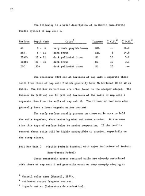
The following is a brief description of an Orthic Humo-FerricPodzol typical of map unit 1 .Horizon Depth (cm) Colorl Texture I C .F .2 I O .M .3Ah 0 - 6 very dark grayish brown SiL -- 16 .2Bhf 6 - 11 dark brown SiL 5 14 .8IIAhb 11 - 21 dark yellowish brown SL 10 5 .2IIBfb 21 - 35 dark brown SL 10 3 .1IN 35+ dark yellowish brown SL 20 --The shallower (
- Page 2 and 3: DETAILED SOIL SURVEYOF THEMOUNT REV
- Page 4 and 5: PageSOIL PRODUCTIVITY 53BIBLIOGRAPH
- Page 6 and 7: LIST OF PLATESPagePLATE 1 . Humo-Fe
- Page 8 and 9: INTRODUCTIONIn recent years Parks C
- Page 10 and 11: THE STUDY AREAGeographic LocationTh
- Page 12 and 13: calcareous rocks in the study area
- Page 14 and 15: Mount Copeland (6,060 feet ASL) .At
- Page 16 and 17: METHODS OF INVESTIGATIONField Techn
- Page 18 and 19: 116 . Pyrophosphate-Extractable Alu
- Page 20 and 21: 13FIGURE 2 .DIAGRAM OF A SOIL PROFI
- Page 22 and 23: 15Soils of the Summit AreaThe soils
- Page 24 and 25: MISCELLANEOUS MAPPING UNITSRBedrock
- Page 28 and 29: 21extremely sloping land surfaces o
- Page 30 and 31: Soil Map Unit 3(Orthic and Cumulic
- Page 32 and 33: 25These soils have severe limitatio
- Page 34 and 35: 27Horizon Depth (cm) Color Texture
- Page 36 and 37: 295-a20 cm-5 -bPlate 5 .The hummock
- Page 38 and 39: 31stands are made up of Abies lasio
- Page 40 and 41: 6-aAeBfR20 cm-6 -bPlate 6 .The Lith
- Page 42 and 43: 37INTERPRETATIONSSoil Properties an
- Page 44 and 45: 39TABLE 4,GUIDES FOR ASSESSING SOIL
- Page 46 and 47: 41TABLE 6 .GUIDES FOR ASSESSING SOI
- Page 48 and 49: 43TABLE 8 .GUIDES FOR ASSESSING SOI
- Page 50 and 51: 45especially where bedrock is close
- Page 52 and 53: TABLE 10 . DEGREE AND NATURE OF SOI
- Page 54 and 55: 49The soils of map units 1, 8 and 9
- Page 56 and 57: 51compounds thus inhibiting percola
- Page 58 and 59: 53PRODUCTIVITYProductivity ratings
- Page 60 and 61: S4 XTABLE 11 . DISTRIBUTION OF SOIL
- Page 62 and 63: 57BIBLIOGRAPHYAlberta Department of
- Page 64 and 65: 59Terzaghi, K . and R .B . Peck . 1
- Page 66 and 67: 61ecosystem .While the activities i
- Page 68 and 69: TABLE A. CLASSES OF FRAGILITY FOR P
- Page 70 and 71: TABLE B. CLASSES OF FRAGILITY FOR S
- Page 72 and 73: 67than to channel use to a rarer ty
- Page 74 and 75: 69approximately 10 cm thickness and
The following is a brief description <strong>of</strong> an Orthic Humo-FerricPodzol typical <strong>of</strong> map unit 1 .Horizon Depth (cm) Colorl Texture I C .F .2 I O .M .3Ah 0 - 6 very dark grayish brown SiL -- 16 .2Bhf 6 - 11 dark brown SiL 5 14 .8IIAhb 11 - 21 dark yellowish brown SL 10 5 .2IIBfb 21 - 35 dark brown SL 10 3 .1IN 35+ dark yellowish brown SL 20 --The shallower (


