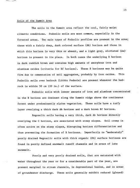
15<strong>Soil</strong>s <strong>of</strong> <strong>the</strong> <strong>Summit</strong> <strong>Area</strong>The soils in <strong>the</strong> <strong>Summit</strong> area reflect <strong>the</strong> cool,fairly moistclimatic conditions .Podzolic soils are most common, especially in <strong>the</strong>forested areas . Two main types <strong>of</strong> Podzolic pr<strong>of</strong>iles are present in <strong>the</strong> area ;those with a fairly deep, dark colored surface (Ah)horizon and those inwhich this horizon is very thin or absent, and a light gray,eluviated (Ae)horizon is present in its place .In both cases <strong>the</strong> underlying B horizonis dark reddish brown and contains high amounts <strong>of</strong> amorphous iron andaluminum oxides (criteria for Bf horizon) . These B horizons may be quitefirm due to cementation <strong>of</strong> soil aggregates, probably by iron oxides .ThinPodzolic soils over bedrock (Lithic Podzols)are present whenever <strong>the</strong> bedrockis within 50 cm (20 in .) <strong>of</strong> <strong>the</strong> surface .Podzolic soils with lesser amounts <strong>of</strong> iron and aluminum concentratedin <strong>the</strong> B horizon are dominant along <strong>the</strong> <strong>Summit</strong> ridge above <strong>the</strong> continuousforest under predominantly alpine vegetation .These soils have a turfylayer overlying a thick dark Ah horizon and a dark brown Bf horizon .Regosolic soils having a very thick, dark Ah horizon directlyoverlying <strong>the</strong> C horizon, are associated with steep slopes .<strong>Soil</strong> creep is<strong>of</strong>ten active on <strong>the</strong> steep slopes, disrupting horizon differentiation andthus preventing <strong>the</strong> formation <strong>of</strong> B horizons .Imperfectly to "moderately"poorly drained Regosolic soils with thick organic (0h)surface horizons arefound in poorly defined snoVmelt run<strong>of</strong>f channels and in areas <strong>of</strong> latesnowmelt .Poorly and very poorly drained soils,that are saturated withwater throughout <strong>the</strong> year or for a considerable part <strong>of</strong> <strong>the</strong> year,arepresent marginal to stream channels, in depressional basins, and in areas<strong>of</strong> groundwater discharge . These soils generally exhibit reduced (gleyed)
TABLE 3.KEY TO THE SOILS OF THE MOUNT REVELSTOKE SUMMIT AREA<strong>Soil</strong> Map Surface Topog-UnFt <strong>Soil</strong> Subgroup Parent Major Horizon raphy Dominant InternalNo . Classification Material Horizons Texture Classes Vegetation Drainage Constants,hallow Occur mostly under alpine vegetation at <strong>the</strong>1 Orthic Humo- aeolian Ah,B(h)f, Carex nigricane north end <strong>of</strong> <strong>the</strong> summit ridge in fairly stableFerric Podzol over till C SiL E,F,G Luetkea well drained slope positions. Bhf horizons <strong>of</strong> logo than 10cm thickness are <strong>of</strong>ten present .These soils occupy snow-It drainage channels3 Orthic and alluvium Oh,(AC), Luetkee imperfectly and erees <strong>of</strong> late snowmelt . Organic aurfaceCumulic Regosol slope wash C Organic C to F Carex nFgricane drained horizons contain 30 to 50% organic matter .a11uvium, poorly and <strong>Soil</strong>s occur in areas <strong>of</strong> groundwater seepage,4 Rego Gleysol lacustrine, Oh,Cg Organic B to F Carex nigricans very poorly and marginal to streams. Surface horizonsvolcanic aah drained contein 60 to 70% organic matter . Volcanic ashlayers caamionly found in pr<strong>of</strong>ile .Eriophorum Surface accumulation <strong>of</strong> peaty organic material .5 Regoalluvium Carex very poorly Occur in areas <strong>of</strong> groundwater seepage, <strong>of</strong>tenpeaty Numic Gleysol slope waeh Of,Ahg,Cg Organic F Sphagnum drained on 15 to 30% slopes .volcanic ash, imperfectly Weakly cry*turbated soils (earth hummocks) in6 Sombric Ferro- alluvium Ah,Bhf, and poorly enclosed basins developed on accumulationsHumic Podzol lacustrine Bhf2,C SiL B to C Carex nigricans drained <strong>of</strong> volcanic ash . Ponding occurs in July .Orthic SombricVa1eriana, Vera-2 Brunisol 6 minor till, Ah 10 cm trum, Heraclem. <strong>Soil</strong> creep is active on steep slopes <strong>of</strong> up toSombric Humo- colluvfum Bm,C SL F,G,H Epilobium, Abies- well drained 755 . Ah is 10 to 40 cm thick .Ferric PodzolVaccFniumAbies-Rhododend-<strong>Soil</strong> creep is very active on very7 steep slopes,Orthic and colluvium Ah (40 cm)Varatrum, causing disruption <strong>of</strong> horizons . Ah is 40 cmCumulic Regoeol till (AC),C SL F,G to,- Senecio, Erigeron, well drained thick. Map unit 7A refers to an avalanche(Graininess) track location <strong>of</strong> <strong>the</strong>se eoil . .Abies-Rhododen-B Sombric , pHumo- C to r dron, Luetkes, Ah >7 .5 cm, occasional ortatein cementationrerr c odrol till Ah,Bf,C SiLCa..iope well drained <strong>of</strong> Bf .Abiee-Rhododen-9 Ortatein Ferro- L-F,Ae(h) dron, VaccFnium The lower Bf horizon is firmly cementedHumic Podzol till Bhf,Bfc,C SL E to C membrenaceum, well drained (ortstein) . No Ah is present .Luetkea,PhyllococeAbies-Rhododend-10 Lithic Hu - till allow L-F,(Ah), ton, Vaccinium, Bedrock Contact occurs at less than 50 cm .Ferric Podzol to bedrock Ae,Bf,R SL C,N Luetkea,Arnica well drained Some <strong>of</strong> <strong>the</strong>se soils have a [hin Ah .