Appendix B - Historic Flooding Tables - Bromsgrove District Council
Appendix B - Historic Flooding Tables - Bromsgrove District Council Appendix B - Historic Flooding Tables - Bromsgrove District Council
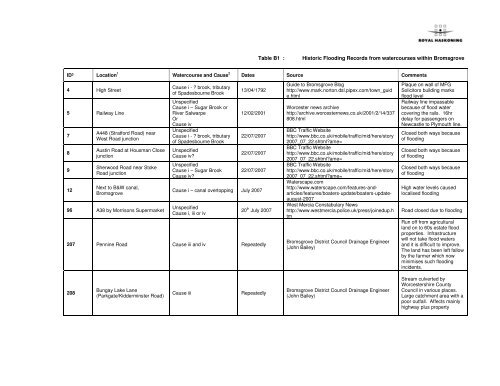
Table B1 :Historic Flooding Records from watercourses within BromsgroveID³ Location 1 Watercourse and Cause 2 Dates Source Comments4 High Street5 Railway Line78912A448 (Stratford Road) nearWest Road junctionAustin Road at Housman ClosejunctionSherwood Road near StokeRoad junctionNext to B&W canal,Bromsgrove96 A38 by Morrisons SupermarketCause i - ? brook, tributaryof Spadesbourne BrookUnspecifiedCause i – Sugar Brook orRiver SalwarpeOrCause ivUnspecifiedCause i - ? brook, tributaryof Spadesbourne BrookUnspecifiedCause iv?UnspecifiedCause i – Sugar BrookCause iv?13/04/179212/02/200122/07/200722/07/200722/07/2007Cause i – canal overtopping July 2007UnspecifiedCause i, iii or iv20 th July 2007207 Pennine Road Cause iii and iv RepeatedlyGuide to Bromsgrove Bloghttp://www.mark.norton.dsl.pipex.com/town_guide.htmlWorcester news archivehttp://archive.worcesternews.co.uk/2001/2/14/337808.htmlBBC Traffic Websitehttp://www.bbc.co.uk/mobile/traffic/mid/here/story2007_07_22.shtml?ame=BBC Traffic Websitehttp://www.bbc.co.uk/mobile/traffic/mid/here/story2007_07_22.shtml?ame=BBC Traffic Websitehttp://www.bbc.co.uk/mobile/traffic/mid/here/story2007_07_22.shtml?ame=Waterscape.comhttp://www.waterscape.com/features-andarticles/features/boaters-update/boaters-updateaugust-2007West Mercia Constabulary Newshttp://www.westmercia.police.uk/press/joinedup.htmBromsgrove District Council Drainage Engineer(John Bailey)Plaque on wall of MFGSolicitors building marksflood levelRailway line impassablebecause of flood watercovering the rails. 16hrdelay for passengers onNewcastle to Plymouth line.Closed both ways becauseof floodingClosed both ways becauseof floodingClosed both ways becauseof floodingHigh water levels causedlocalised floodingRoad closed due to floodingRun off from agriculturalland on to 60s estate floodproperties. Infrastructurewill not take flood watersand it is difficult to improve.The land has been left fallowby the farmer which nowminimises such floodingincidents.208Bungay Lake Lane(Parkgate/Kidderminster Road)Cause iiiRepeatedlyBromsgrove District Council Drainage Engineer(John Bailey)Stream culverted byWorcestershire CountyCouncil in various places.Large catchment area with apoor outfall. Affects mainlyhighway plus property
- Page 2 and 3: ID³ Location 1 Watercourse and Cau
- Page 4 and 5: ID³ Location 1 Watercourse and Cau
- Page 6 and 7: ID³ Location 1 Watercourse and Cau
- Page 8 and 9: ID³ Location 1 Watercourse and Cau
- Page 10 and 11: ID³ Location 1 Watercourse and Cau
- Page 12 and 13: Notes1. The above is not an exhaust
- Page 14 and 15: ID³ Location 1 Watercourse and Cau
- Page 16 and 17: ID³ Location 1 Watercourse and Cau
- Page 18 and 19: ID³ Location 1 Watercourse and Cau
- Page 20 and 21: ID³ Location 1 Watercourse and Cau
- Page 22 and 23: ID³ Location 1 Watercourse and Cau
- Page 24 and 25: ID³ Location 1 Watercourse and Cau
- Page 26 and 27: ID³ Location 1 Watercourse and Cau
- Page 28 and 29: ID³ Location 1 Watercourse and Cau
- Page 30: Notes1. The above is not an exhaust
Table B1 :<strong>Historic</strong> <strong>Flooding</strong> Records from watercourses within <strong>Bromsgrove</strong>ID³ Location 1 Watercourse and Cause 2 Dates Source Comments4 High Street5 Railway Line78912A448 (Stratford Road) nearWest Road junctionAustin Road at Housman ClosejunctionSherwood Road near StokeRoad junctionNext to B&W canal,<strong>Bromsgrove</strong>96 A38 by Morrisons SupermarketCause i - ? brook, tributaryof Spadesbourne BrookUnspecifiedCause i – Sugar Brook orRiver SalwarpeOrCause ivUnspecifiedCause i - ? brook, tributaryof Spadesbourne BrookUnspecifiedCause iv?UnspecifiedCause i – Sugar BrookCause iv?13/04/179212/02/200122/07/200722/07/200722/07/2007Cause i – canal overtopping July 2007UnspecifiedCause i, iii or iv20 th July 2007207 Pennine Road Cause iii and iv RepeatedlyGuide to <strong>Bromsgrove</strong> Bloghttp://www.mark.norton.dsl.pipex.com/town_guide.htmlWorcester news archivehttp://archive.worcesternews.co.uk/2001/2/14/337808.htmlBBC Traffic Websitehttp://www.bbc.co.uk/mobile/traffic/mid/here/story2007_07_22.shtml?ame=BBC Traffic Websitehttp://www.bbc.co.uk/mobile/traffic/mid/here/story2007_07_22.shtml?ame=BBC Traffic Websitehttp://www.bbc.co.uk/mobile/traffic/mid/here/story2007_07_22.shtml?ame=Waterscape.comhttp://www.waterscape.com/features-andarticles/features/boaters-update/boaters-updateaugust-2007West Mercia Constabulary Newshttp://www.westmercia.police.uk/press/joinedup.htm<strong>Bromsgrove</strong> <strong>District</strong> <strong>Council</strong> Drainage Engineer(John Bailey)Plaque on wall of MFGSolicitors building marksflood levelRailway line impassablebecause of flood watercovering the rails. 16hrdelay for passengers onNewcastle to Plymouth line.Closed both ways becauseof floodingClosed both ways becauseof floodingClosed both ways becauseof floodingHigh water levels causedlocalised floodingRoad closed due to floodingRun off from agriculturalland on to 60s estate floodproperties. Infrastructurewill not take flood watersand it is difficult to improve.The land has been left fallowby the farmer which nowminimises such floodingincidents.208Bungay Lake Lane(Parkgate/Kidderminster Road)Cause iiiRepeatedly<strong>Bromsgrove</strong> <strong>District</strong> <strong>Council</strong> Drainage Engineer(John Bailey)Stream culverted byWorcestershire County<strong>Council</strong> in various places.Large catchment area with apoor outfall. Affects mainlyhighway plus property
ID³ Location 1 Watercourse and Cause 2 Dates Source Comments209 Birmingham Road/The StrandCause iiiSEWERRepeatedly210 Market Street Cause iii Repeatedly211 Watt Close Cause iii and i Repeatedly<strong>Bromsgrove</strong> <strong>District</strong> <strong>Council</strong> Drainage Engineer(John Bailey)<strong>Bromsgrove</strong> <strong>District</strong> <strong>Council</strong> Drainage Engineer(John Bailey)<strong>Bromsgrove</strong> <strong>District</strong> <strong>Council</strong> Drainage Engineer(John Bailey)Spadesbourne passesbeneath The Strand. Largeculvert partially cleared outby Worcestershire County<strong>Council</strong> but premises areaffected by highway waternot getting away.Also the Severn Trent Waterbalancing tank off line fromthe foul water sewer,otherwise High Streetproperties affected bysurcharge within 1884combined sewer.Two hidden weirs on line ofSpadesbourne, will floodproperties at Southern endof high street if obstructed.<strong>Bromsgrove</strong> <strong>District</strong> <strong>Council</strong>land aroundSpadesbourne/BattlefieldBrook will become flooded.Is a good control point.Downstream restricted byFord Road Bridge. BrookRoad properties can beaffected by flooding.212 Worcester Road/Charford Cause iii and i Repeatedly<strong>Bromsgrove</strong> <strong>District</strong> <strong>Council</strong> Drainage Engineer(John Bailey)Bridging points hold backflows. Occasional floodingon Worcester Road.Charford Road, with theSpadesbourne by its sidehas a deep profile thusacting as a storage areaprotecting Sugarbrook areathat has limited floodingopposite public house.
ID³ Location 1 Watercourse and Cause 2 Dates Source Comments213214Old Station Road/Bank MillRoadStonehouse Road/WellingtonRoadCause iiiSEWERCause iii and iRepeatedlyRepeatedly<strong>Bromsgrove</strong> <strong>District</strong> <strong>Council</strong> Drainage Engineer(John Bailey)<strong>Bromsgrove</strong> <strong>District</strong> <strong>Council</strong> Drainage Engineer(John Bailey)Properties flood due toinadequate highway drainsalong with recentdevelopment adding stormdischarge both to the fouland highway drain.<strong>Bromsgrove</strong> <strong>District</strong> <strong>Council</strong>arranged a hydro brake ontofoul/combined. Four housespreviously affected.Stream divides properties.Lacks capacity andmaintenance. Run off fromthe highways beingunattenuated is a problem,as is the downstreamculvert. Three houses plusgardens are affected on aregular basis.215 Stoke Road (Morrisons)Cause i – Sugar BrookSEWERSRepeatedly<strong>Bromsgrove</strong> <strong>District</strong> <strong>Council</strong> Drainage Engineer(John Bailey)Traffic island area becomesflooded during high flowsand prolonged storm. Is online to the main sewerageworks. Along with numerousstorm water sewers andhighway drains to TheSugarbrook Works hassupposedly corrected maininlet to accommodate thissituation. Major works to allsewers required.
ID³ Location 1 Watercourse and Cause 2 Dates Source Comments216 Buntsford Hill/Fish House LaneCause i – River SalwarpeRepeatedly<strong>Bromsgrove</strong> <strong>District</strong> <strong>Council</strong> Drainage Engineer(John Bailey)The River Salwarpe burstsits banks onto the adjoininghighway closing off thevalley and isolating varioushouses. EA needs to put inextra storage in this are inthe way of recreating floodplans.217Fish House Lane – ManorHouseCause i and iiiRepeatedly<strong>Bromsgrove</strong> <strong>District</strong> <strong>Council</strong> Drainage Engineer(John Bailey)Subsidiary stream joins theRiver Salwarpe. Backs upinstantly to house. Recentflood defence scheme haseased the situation butupstream between therailway and canal propertyagain floods due torestrictive culverts.Notes1. The above is not an exhaustive list of flooding records.2. Causes of floodingi. Overflow of watercourses and existing flood defences including water retention facilities such as flood storage reservoirs/washlands and storm water balancingponds;ii. Breaching of flood defences (including flood storage areas)iii. Mechanical, structural or operational failure (including due to blockages) or hydraulic structures, pumps etc;iv. Localised surface water flooding (including sewer flooding and overland flooding);v. Functional Floodplains or Washlands; andvi. Groundwater flooding.3. Italic and underlined numbers indicate a general, unspecified location (e.g. an event affecting an entire town or a long stretch of river)
Table B2 :<strong>Historic</strong> <strong>Flooding</strong> Records from watercourses within RedditchID³ Location 1 Watercourse and Cause 2 Dates Source Comments17Abbotswood Close, WinyatesGreenIpsley BrookCause i, iii, ivRepeatedlyDatabase provided by Redditch Borough <strong>Council</strong>Drainage Engineer (Clive Wilson)Approximately 5 housesflooded internally fromoverland flow1 house flooded externallyfrom land drainage,highway and sewerflooding19 Allensmore Close, Matchborough20 Arley Close, Church HillIpsley BrookCause i, iii, ivChurchill BrookCause i and iv20/07/0720/07/0721 Ashperton Close, Southcrest Cause iv 20/07/0722 Ash Tree Road, Batchley24 Atcham Close, MatchboroughBatchley BrookCause i and Cause ivIpsley BrookCause i and cause iv20/07/0720/07/0725 Atherstone Close, Matchborough Ipsley Brook 20/07/0726 Batchley Road, Batchley Batchley Brook 20/07/0727 Beech Tree Close, BatchleyBatchley BrookCause i and Case ivRepeatedlyRedditch <strong>Council</strong> ‘Policy Statement on FloodDefence, Revised Dec 2005Database provided by Redditch Borough <strong>Council</strong>Drainage Engineer (Clive Wilson)Database provided by Redditch Borough <strong>Council</strong>Drainage Engineer (Clive Wilson)Database provided by Redditch Borough <strong>Council</strong>Drainage Engineer (Clive Wilson)Database provided by Redditch Borough <strong>Council</strong>Drainage Engineer (Clive Wilson)Database provided by Redditch Borough <strong>Council</strong>Drainage Engineer (Clive Wilson)Database provided by Redditch Borough <strong>Council</strong>Drainage Engineer (Clive Wilson)Database provided by Redditch Borough <strong>Council</strong>Drainage Engineer (Clive Wilson)Database provided by Redditch Borough <strong>Council</strong>Drainage Engineer (Clive Wilson)Earth Flood bundconstructed to protecthouses in AbbotswoodCloseApproximately 8 housesflooded internally and 3houses flooded externallyfrom land drainage, seweroverflow and highwaysrunoff.Approximately 3 housesflooded externally fromland drainage and brookoverflow.Approximately 10 housesflooded externally byoverland flow (landdrainage)1 house suffered externalflooding1 house flooded externallyfrom land drainageproblems1 house affected1 house affectedApproximately 11 housesaffected by internalflooding and 3 housesaffected by externalflooding as a result of landdrainage.
ID³ Location 1 Watercourse and Cause 2 Dates Source Comments29 Brinklow Close, Matchborough Not Known 20/07/0730 <strong>Bromsgrove</strong> Road, Batchley Cause iii and iv 20/07/0731 Brooklands LaneDagnell BrookCause i20/07/07FormerlyRepeatedly untilQ100 workscompleted in themid 1990s.32 Cedar Road, Batchley Cause iii and iv 20/07/0734 Cheswick Close, WinyatesCause iii(illegal works/obstructions inrear gardens)Repeatedly35 Church Road, Webheath Cause iv 20/07/0736 Crabbs Cross Lane, Crabbs Cross Cause iv 20/07/0737 Dairy Lane, Brockhill Cause iv 20/07/0738 Dolphin Road, Abbeydale Cause iii and iv 20/07/0740 Dunlop Road, Hunt EndThe WharrageCause i and iv20/07/0741 Edgmond Close, Winyates Unspecified 20/07/0742 Mason Road, Headless Cross Cause iii 20/07/0743 Exhall Close, Church HillUnspecifiedSome cause iii20/07/0744 Flanders Close, Church Hill Unspecified 20/07/0745 Forge Mill Road, Riverside Cause iii 20/07/07Database provided by Redditch Borough <strong>Council</strong>Drainage Engineer (Clive Wilson)Database provided by Redditch Borough <strong>Council</strong>Drainage Engineer (Clive Wilson)Database provided by Redditch Borough <strong>Council</strong>Drainage Engineer (Clive Wilson)Database provided by Redditch Borough <strong>Council</strong>Drainage Engineer (Clive Wilson)Database provided by Redditch Borough <strong>Council</strong>Drainage Engineer (Clive Wilson)Database provided by Redditch Borough <strong>Council</strong>Drainage Engineer (Clive Wilson)Database provided by Redditch Borough <strong>Council</strong>Drainage Engineer (Clive Wilson)Database provided by Redditch Borough <strong>Council</strong>Drainage Engineer (Clive Wilson)Database provided by Redditch Borough <strong>Council</strong>Drainage Engineer (Clive Wilson)Database provided by Redditch Borough <strong>Council</strong>Drainage Engineer (Clive Wilson)Database provided by Redditch Borough <strong>Council</strong>Drainage Engineer (Clive Wilson)Database provided by Redditch Borough <strong>Council</strong>Drainage Engineer (Clive Wilson)Database provided by Redditch Borough <strong>Council</strong>Drainage Engineer (Clive Wilson)Database provided by Redditch Borough <strong>Council</strong>Drainage Engineer (Clive Wilson)Database provided by Redditch Borough <strong>Council</strong>Drainage Engineer (Clive Wilson)1 property floodedexternallyApproximately 15properties floodedinternally – 3 from sewerand highway flooding and12 from land drainageproblems1 house flooded externally3 houses floodedexternally1 house internally floodedand 1 house externallyflooded1 house internally flooded1 house internally flooded1 house flooded internallyfrom land drainageproblems7 houses floodedexternally from sewers andhighways10 business units internallyflooded from sewers1 house externally flooded1 house flooded externallyfrom highways flooding2 houses floodedexternally.1 house flooded internallyfrom highways drainage1 house externally flooded2 houses floodedexternally from highwaysflooding
ID³ Location 1 Watercourse and Cause 2 Dates Source CommentsDatabase provided by Redditch Borough <strong>Council</strong>2 houses externally46 Foxlydiate Crescent, Batchley Cause iv 20/07/07 Drainage Engineer (Clive Wilson)flooded from land drainage47 Furze Lane, Winyates Green Cause iv 20/07/0748 Goodrich Close, Winyates West Cause iii and iv 20/07/0749 Greenlands Avenue, Greenlands Unspecified 20/07/0750 Haseley Close, Matchborough East Cause iii and iv 20/07/0751 Highley Close, Church Hill53 Hillmorton Close, Church HillChurch Hill BrookCause i and ivChurchill BrookCause i, iii and iv20/07/0720/07/0754 Hither Green Lane, Abbey Park Cause iv 20/07/0755St Bede’s School, Holloway Lane,Lakeside56 Holyoaks Close, Winyates East57 Ibstock Close, Winyates WestCause iv 20/07/07Ipsley Brook,Cause i, iii and ivBlacksoils BrookCause i, iii and iv20/07/0720/07/0758 Ilmington Close, Matchborough Unspecified 20/07/0759 Ipsley Church Lane, Ipsley Cause iv 20/07/0760Kempsey Close, Woodrow,Winyates WestUnspecified 20/07/0761 Kinnersley Close Unspecified 20/07/0762 Ladygrove Close, Greenlands Unspecified 20/07/0763 Linton Close, Matchborough Cause iii and iv 20/07/07Database provided by Redditch Borough <strong>Council</strong>Drainage Engineer (Clive Wilson)Database provided by Redditch Borough <strong>Council</strong>Drainage Engineer (Clive Wilson)Database provided by Redditch Borough <strong>Council</strong>Drainage Engineer (Clive Wilson)Database provided by Redditch Borough <strong>Council</strong>Drainage Engineer (Clive Wilson)Database provided by Redditch Borough <strong>Council</strong>Drainage Engineer (Clive Wilson)Database provided by Redditch Borough <strong>Council</strong>Drainage Engineer (Clive Wilson)Database provided by Redditch Borough <strong>Council</strong>Drainage Engineer (Clive Wilson)Database provided by Redditch Borough <strong>Council</strong>Drainage Engineer (Clive Wilson)Database provided by Redditch Borough <strong>Council</strong>Drainage Engineer (Clive Wilson)Database provided by Redditch Borough <strong>Council</strong>Drainage Engineer (Clive Wilson)Database provided by Redditch Borough <strong>Council</strong>Drainage Engineer (Clive Wilson)Database provided by Redditch Borough <strong>Council</strong>Drainage Engineer (Clive Wilson)Database provided by Redditch Borough <strong>Council</strong>Drainage Engineer (Clive Wilson)Database provided by Redditch Borough <strong>Council</strong>Drainage Engineer (Clive Wilson)Database provided by Redditch Borough <strong>Council</strong>Drainage Engineer (Clive Wilson)Database provided by Redditch Borough <strong>Council</strong>Drainage Engineer (Clive Wilson)Business premises floodedexternally from landdrainage1 house flooded fromsewer and highwayflooding1 house flooded externally1 house flooded externallyby highway drainageflooding2 houses floodedexternally from landdrainage1 house flooded externallyfrom overbank, sewer andhighway flooding1 house and golf coursesuffered external floodingSchool flooded internallyby sewersApproximately 7 housessuffered external floodingfrom land drainage, sewersand highway4 houses internally floodedfrom highways drainage.4 houses externallyflooded from land drainage1 house flooded externally1 house flooded externallyfrom land drainageApproximately 7 housesflooded externally1 house flooded2 houses externallyflooded1 house flooded by sewersand highways
ID³ Location 1 Watercourse and Cause 2 Dates Source Comments20/07/07Formerly65 Loxley Close, Church Hillrepeatedly,Approximately 11 housesprogressiveChurch Hill BrookDatabase provided by Redditch Borough <strong>Council</strong> externally flooded and 1reductions inCause i and ivDrainage Engineer (Clive Wilson)house internally floodedfrequency andfrom land drainagemagnitudefollowing variousimprovements66Middleton Close, MappleboroughGreenCause iii and iv 20/07/0767 Milcote Close, Greenlands Unspecified 20/07/0768 Milhill Road, MatchboroughIpsley BrookCause i?20/07/0769 Napton Close, Matchborough Unspecified 20/07/0771 Northleach Close, Church Hill Cause iii and iv 20/07/0772 Oak Tree Avenue, BatchleyBatchley BrookCause i and iv20/07/0773 Ombersley Close, Church Hill Cause iv 20/07/0774 Oxleasow Road, Moons Moat Unspecified 20/07/0775 Patch Lane, Oakenshaw North Unspecified 20/07/0776 Pebworth Close, Church Hill Unspecified 20/07/0777 Plymouth Road, Southcrest Unspecified 20/07/0778 Poplar Road, Batchley Unspecified 20/07/0779 Proctors Barn Lane, LakesideUnspecifiedRiver Arrow?20/07/0780 Pulman Close, Batchley Unspecified 20/07/0781 Quinton Close, Matchborough Unspecified 20/07/07Database provided by Redditch Borough <strong>Council</strong>Drainage Engineer (Clive Wilson)Database provided by Redditch Borough <strong>Council</strong>Drainage Engineer (Clive Wilson)Database provided by Redditch Borough <strong>Council</strong>Drainage Engineer (Clive Wilson)Database provided by Redditch Borough <strong>Council</strong>Drainage Engineer (Clive Wilson)Database provided by Redditch Borough <strong>Council</strong>Drainage Engineer (Clive Wilson)Database provided by Redditch Borough <strong>Council</strong>Drainage Engineer (Clive Wilson)Database provided by Redditch Borough <strong>Council</strong>Drainage Engineer (Clive Wilson)Database provided by Redditch Borough <strong>Council</strong>Drainage Engineer (Clive Wilson)Database provided by Redditch Borough <strong>Council</strong>Drainage Engineer (Clive Wilson)Database provided by Redditch Borough <strong>Council</strong>Drainage Engineer (Clive Wilson)Database provided by Redditch Borough <strong>Council</strong>Drainage Engineer (Clive Wilson)Database provided by Redditch Borough <strong>Council</strong>Drainage Engineer (Clive Wilson)Database provided by Redditch Borough <strong>Council</strong>Drainage Engineer (Clive Wilson)Database provided by Redditch Borough <strong>Council</strong>Drainage Engineer (Clive Wilson)Database provided by Redditch Borough <strong>Council</strong>Drainage Engineer (Clive Wilson)1 house externally floodedby sewer and highwaydrainage1 property internallyflooded1 house externally flooded1 house externally flooded10 houses externallyflooded by sewers andhighway flooding3 houses internally floodedfrom sewers1 house internally floodedand 8 externally floodedfrom land drainage1 house externally floodedby sewers1 business unit internallyflooded2 houses externallyflooded1 house flooded(externally?)1 house externally flooded1 house externally flooded1 house flooded1 house internally floodedand 1 house externallyflooded1 house externally flooded
ID³ Location 1 Watercourse and Cause 2 Dates Source Comments82 Salters Lane, BrockhillBatchley BrookCause i and iv20/07/07Repeatedlyfollowingconstruction ofdwellings in early2000sRegular,sporadic84 Sandhurst Close, Church Hill Cause iii and iv 20/07/0785 Snowshill Close, Church Hill Cause iii and iv 20/07/0788 Watery Lane, Greenlands Cause iii and iv 20/07/0789 Windsor Road, EnfieldRed DitchCause iFormerlyinfrequentflooding prior toBrockhillDevelopment.Enforcementactions securedimprovedperformance,neverthelessfloodingoccurred on20/07/0790 Woodland Road, Batchley Cause iii/iv 20/07/07Database provided by Redditch Borough <strong>Council</strong>Drainage Engineer (Clive Wilson)Redditch Borough <strong>Council</strong> Drainage Engineer(Clive Wilson) – anecdotal local knowledgeDatabase provided by Redditch Borough <strong>Council</strong>Drainage Engineer (Clive Wilson)Database provided by Redditch Borough <strong>Council</strong>Drainage Engineer (Clive Wilson)Database provided by Redditch Borough <strong>Council</strong>Drainage Engineer (Clive Wilson)Database provided by Redditch Borough <strong>Council</strong>Drainage Engineer (Clive Wilson)Database provided by Redditch Borough <strong>Council</strong>Drainage Engineer (Clive Wilson)1 house internally floodedby sewers and 1 houseexternally flooded bysewersHighways and Drainage –Highway flooding in excessof 700mm depthFormer farm land1 house internally and 1house externally floodedby sewer and highwaysdrainage1 house flooded externallyfrom sewers and highwaysdrainageApproximately 7 housesflooded internally fromsewers and highwaysdrainage1 business floodedinternally from landdrainage1 property externallyflooded from highwaysdrainage
ID³ Location 1 Watercourse and Cause 2 Dates Source Comments91 Plymouth Road, SouthcrestUnspecified. Assumed causei and/or ivEarly 1930sA new reliefSurface WaterSewer wasconstructed bySTWL in1978/79 whichalso significantlyimproveddrainageperformance.92 Garage, Redditch, unspecified Cause iv June 200793 Oakly Road and Station WayCause i and iii(General lack of proper gullyprovision in terms of bothnumbers and siting)November 2005Redditch Advertiserhttp://www.redditchadvertiser.co.uk/news/ranewspicturegalleries/reddnewsgalleryhistoricpictures/BBC Hereford and Worcesterhttp://www.bbc.co.uk/herefordandworcester/content/image_galleries/raw_sewage_redditch_garage_gallery.shtml?2<strong>Bromsgrove</strong> Advertiserhttp://archive.bromsgroveadvertiser.co.uk/2005/11/23/387027.html‘…severe flooding…’New seats inRemembrance Gardencarried away anddeposited on warmemorial. Car’s carriedalong in flood. Furtherdown road a waterfall fromthe road through thegarden grounds onto thetrain station platform.Some years later the roadlevel was raised whichreduced the risk of furtherflooding.Business garage floodedwith sewage – flooded 3times in 6 weeksBlocked drains causingflooding at Redditch busstation“torrents of water” pourdown Oakly road into taxirank9597A441 Dagnell End Road/WeightsLaneArrow Valley from RedditchdownstreamUnspecifiedCause i, iii or ivRiver ArrowCause i20 th July 2007December 1900(Also 1870s and1880s)West Mercia Constabulary Newshttp://www.westmercia.police.uk/press/joinedup.htmAlcester Local Pasthttp://www.alcester.dial.pipex.com/localpast/96wn/wn96flo.htmRoad closed due tofloodingTorrential Rain“…general picture ofdestruction from Redditchdownwards…”98Winyates Way,Matchborough/WinyatesUnspecifiedPossibly cause i, iii or iv23 rd July 2007Redditch Advertiserhttp://www.redditchadvertiser.co.uk/search/display.var.1565297.0.your_flood_photos.phpPhoto99 Battens Drive, South Moons MoatUnspecifiedPossibly cause i, iii or iv23 rd July 2007Redditch Advertiserhttp://www.redditchadvertiser.co.uk/search/display.var.1565311.0.your_flood_photos.phpPhoto
ID³ Location 1 Watercourse and Cause 2 Dates Source CommentsRedditch Advertiserhttp://www.redditchadvertiser.co.uk/search/display.var.1565416.0.your_flood_photos.php100http://www.redditchadvertiser.co.uk/search/displayBatchley Brook, between Brockhill Unspecified23 rd PhotoJuly 2007 .var.1565378.0.your_flood_photos.phpDrive and Batchley RoadPossibly cause i, iii or ivSee also ID82http://www.redditchadvertiser.co.uk/search/display.var.1565406.0.your_flood_photos.phphttp://www.redditchadvertiser.co.uk/search/index.var.1.20.flood.php101 Brockhill and Batchley (general)102 Bordesley Lane, RiversideUnspecifiedPossibly cause i, iii or ivUnspecifiedPossibly cause i, iii or iv23 rd July 200723 rd July 2007Redditch Advertiserhttp://www.redditchadvertiser.co.uk/search/index.var.1.20.flood.phpRedditch Advertiserhttp://www.redditchadvertiser.co.uk/search/display.var.1565491.0.your_flood_photos.phpPhotoPhoto103 Batons Drive, South Moons Moat104 Park Way, Abbeydale106Underpass at end of Beoley Roadunder Holloway Drive, LakesideUnspecifiedPossibly cause i, iii or ivUnspecifiedPossibly cause i, iii or iv23 rd July 200723 rd July 2007Cause iii 4 th June 2007108 Sedgley Close Unspecified 20/07/07109 Green Lane, Studley Cause iv 20/07/07124 Rosedale Close and Salters Lane UnspecifiedRegularly andRecentlyRedditch Advertiserhttp://www.redditchadvertiser.co.uk/search/display.var.1565376.0.your_flood_photos.phpRedditch Advertiserhttp://www.redditchadvertiser.co.uk/search/display.var.1565496.0.your_flood_photos.phpRedditch Advertiserhttp://www.redditchadvertiser.co.uk/search/display.var.1446168.0.boat_and_bath_in_underpass_flood.phpDatabase provided by Redditch Borough <strong>Council</strong>Drainage Engineer (Clive Wilson)Database provided by Redditch Borough <strong>Council</strong>Drainage Engineer (Clive Wilson)Ex-Resident – conversation125 B97 4LE, Birchfield Road Cause iii Regularly Relative of Resident – conversationPhotoSee also ID 99PhotoSeveral feet of water for 2weeks as a result of afailed pump1 house flooded externally1 house flooded internallyHouses flooded internallyand externally1 house floods externally ingarden due to blockeddrains. Neighbours are notaffected
Notes1. The above is not an exhaustive list of flooding records.2. Causes of floodingi. Overflow of watercourses and existing flood defences including water retention facilities such as flood storage reservoirs/washlands and storm water balancingponds;ii. Breaching of flood defences (including flood storage areas)iii. Mechanical, structural or operational failure (including due to blockages) or hydraulic structures, pumps etc;iv. Localised surface water flooding (including sewer flooding and overland flooding);v. Functional Floodplains or Washlands; andvi. Groundwater flooding.3. Italic and underlined numbers indicate a general, unspecified location (e.g. an event affecting an entire town or a long stretch of river)
Table B3 :<strong>Historic</strong> <strong>Flooding</strong> Records from watercourses within Other Areas in <strong>Bromsgrove</strong> <strong>District</strong>ID³ Location 1 Watercourse and Cause 2 Dates Source Comments1 Hanbury Road, Stoke Prior Cause i – canal or cause iv 30 October 20002 Houndsfield Lane, Wythall Cause i 30 October 20003Converted Barn, Dagnell EndFarm6 Railway Line at M42 Bridge10Stoney Lane near B4096 HawellLane junction, Tutnall11 MarlbrookCause ivUnspecifiedCause i – ordinarywatercourse beside lineOrCause ivUnspecifiedCause i – B&W canalOrCause ivUnspecifiedPresumed Cause i fromunnamed OrdinaryWatercourseRecently12/02/200122/07/2007July 2007Worcester News Archive onlinehttp://archive.worcesternews.co.uk/2000/11/1/350651.htmlWorcester News Archive onlinehttp://archive.worcesternews.co.uk/2000/11/1/350651.html<strong>Bromsgrove</strong> <strong>District</strong> <strong>Council</strong> DrainageEngineer (John Bailey)Worcester news archivehttp://archive.worcesternews.co.uk/2001/2/14/337808.htmlBBC Traffic Websitehttp://www.bbc.co.uk/mobile/traffic/mid/here/story2007_07_22.shtml?ame=BBC Hereford and Worcester websitehttp://www.bbc.co.uk/herefordandworcester/content/image_galleries/flash_floods_new_july_gallery.shtml?26Floods under railway bridge waisthigh.One car left floatingFloods 6ft deep at fordBarn is below road level ondownstream side. Frequent floodproblem“…there were further floods on theline near Barnt Green on the bridgeover the M42”Closed both ways because offloodingRoad flooded and flood defenceserectedHigh water levels caused localisedflooding13Next to B&W canal, Stoke PriorAdjacent to the B4091Cause i – canal overtoppingCause i – canal overtoppingand cause ivJuly 2007July 2007Waterscape.comhttp://www.waterscape.com/featuresand-articles/features/boatersupdate/boaters-update-august-2007British WaterwaysOvertopping of the Worcester andBirmingham canal in Stoke Prioradjacent to the B4091. Due to theextreme weather conditions whichresulted in water inundation of thecanal from the adjacent Hen Brookand extreme surface water volumesentering the canal.
ID³ Location 1 Watercourse and Cause 2 Dates Source Comments14151694105Land adjacent to Callow Brook(behind 141-159 New Road andA8)Beaudesert Road, Drakes Cross(open space behind library)Adjacent to 528 Groveley Lane,Cofton HackettJunction Redhill Road and A441(West Heath)The Farm Animal Sanctuary,Stoney Lane, TardebiggeUnspecifiedCause i – Callow Brook?Or Cause ivUnspecified <strong>Bromsgrove</strong> Housing Capacity 2004 <strong>Flooding</strong> IssuesCause i – stream Intermittently <strong>Bromsgrove</strong> Housing Capacity 2004 Can flood in placesUnspecified Unspecified <strong>Bromsgrove</strong> Housing Capacity 2004 Problems with floodingUnspecifiedCause i, iii or ivUnspecifiedCause iv15/06/2007July 2007107 Hanbury Road, Stoke Prior Cause i plus cause iv July 2007110House on A38 downhill from M5,Junction 4bbc.co.uk/mobile(Traffic Birmingham)Redditch Advertiserhttp://www.redditchadvertiser.co.uk/search/display.var.1601008.0.event_raises_cash_for_flood_damage.phpRedditch Advertiserhttp://www.bromsgroveadvertiser.co.uk/search/display.var.1614460.0.crunch_talks_on_flooding.phpCause iii and iv 24 July 2007 Highways Agency (Amey Mouchel)111 A456 Hagley Wood Roundabout Cause iii / iv 25 June 2007 Highways Agency (Amey Mouchel)112113114Layby on A456 between HayleyGreen and Hagley WoodRoundaboutA456 Eastbound from A491Roundabout to Wassell GroveRoundaboutM42 Northbound, Junction 1 entryslipCause iv 15 January 2008 Highways Agency (Amey Mouchel)Cause vi 15 January 2008 Highways Agency (Amey Mouchel)Cause iii 14 th June 2007 Highways Agency (Amey Mouchel)115 M42 Northbound slip at Junction 3 Cause iii 16 th June 2007 Highways Agency (Amey Mouchel)<strong>Flooding</strong> on Redditch Road (A441)both ways at Redhill Road junction inWest HeathFlash floods damaged fences andsubmerged hay fields5 cottages flooded internally. 2streams under canal overflowed intocanal, in addition to surface runoffand caused the canal to overtopM5 badly affected by heavy rain,runoff left motorway and flowed downfields, surrounding a property at thebottom. Residents had to acquire 2pumps to stop house from flooding.<strong>Flooding</strong> in Lane 1 and ontoapproach to RoundaboutWater collecting at bottom of fieldand running into laybyWater gushing from the embankment(approximately 10” wide)Known place for flooding due to gullylocation – gully is clear and water isvery slowly dispersingPossible blocked drain as waterflooding from layby opposite ERTphone and about to flood into Lane 1116 M42 Junction 2 – Junction 1 Cause iii? 20 th July 2007 Highways Agency (Amey Mouchel) Standing water due to heavy rain
ID³ Location 1 Watercourse and Cause 2 Dates Source Comments117 M42 Junction 3 – Junction 2 Cause iii and Cause iv 15 th August 2007 Highways Agency (Amey Mouchel)118M42 Northbound Junction 1 entryslipWater running off field andencroaching onto the hard shoulder.Drains further up are blocked.French drain loosened, hard shoulderclosure emplaced and gully suckerrequired.Cause iv (and iii?) 10 th March 2008 Highways Agency (Amey Mouchel) Water ponding at bottom of entry slip119 M5 Northbound, Junction 4a Cause iv (and iii?) 8 th June 2007 Highways Agency (Amey Mouchel)120121122M5 Northbound, Junction 4A toJunction 4M5 Southbound – Junction 4A –Junction 5M5 Southbound – Junction 3 toJunction 4Cause iii and iv 20 th July 2007 Highways Agency (Amey Mouchel) Standing waterUnspecified(cause iii or iv)123 Clent Road Estate Cause iv Previously126 Cobnall Road, Catshill Cause i and iii Repeatedly127 Marlbrook128 Callowbrook Lane, Rubery<strong>Flooding</strong> on hard shoulder, possiblyfrom a nearby field20 th July 2007 Highways Agency (Amey Mouchel) Reports of floodingCause iii or iv 16 th March 2008 Highways Agency (Amey Mouchel) Reports of standing waterCause iBattlefield BrookCause i and iiiCallow BrookRepeatedlyRepeatedly129 Birches Lane, Alvechurch Cause iii Recently130 Hollywood/Wythall area Cause iv Repeatedly131 Cottage Lane, Marlbrook Cause iv Repeatedly132 Fishouse Lane, Stoke PriorCause iRiver SalwarpeRepeatedly<strong>Bromsgrove</strong> Advertiserhttp://www.bromsgroveadvertiser.co.uk/search/display.var.1633631.0.residents_call_for_flood_action.php<strong>Bromsgrove</strong> <strong>District</strong> <strong>Council</strong> DrainageEngineer (John Bailey)<strong>Bromsgrove</strong> <strong>District</strong> <strong>Council</strong> DrainageEngineer (John Bailey)<strong>Bromsgrove</strong> <strong>District</strong> <strong>Council</strong> DrainageEngineer (John Bailey)<strong>Bromsgrove</strong> <strong>District</strong> <strong>Council</strong> DrainageEngineer (John Bailey)<strong>Bromsgrove</strong> <strong>District</strong> <strong>Council</strong> DrainageEngineer (John Bailey)<strong>Bromsgrove</strong> <strong>District</strong> <strong>Council</strong> DrainageEngineer (John Bailey)<strong>Bromsgrove</strong> <strong>District</strong> <strong>Council</strong> DrainageEngineer (John Bailey)Drainage problems. Fears thatproposed temporary buildings for thejunior football club may cause futuredrainage problemsThe piped watercourse cannot copeThe catchment has been infilled andthe brook can’t cope with the stormrunoff.Culvert capacity problems have ledto repeated flooding of a house.Storm culvert cannot cope and tendsto floodClay causes land drainage problemsProblems with runoffFlooded in past133 Fishouse LaneCause iRiver Salwarpe and HennBrookRepeatedly<strong>Bromsgrove</strong> <strong>District</strong> <strong>Council</strong> DrainageEngineer (John Bailey)Problems with excess storm waterfrom railway and canal causesflooding at the confluence
ID³ Location 1 Watercourse and Cause 2 Dates Source Comments134Between Morrisons and IndoorBowl CentreCause iSugar BrookRepeatedly<strong>Bromsgrove</strong> <strong>District</strong> <strong>Council</strong> DrainageEngineer (John Bailey)Flooded in past135Ford Road, Watt Close, BrookRoadBetween confluence of BattlefieldBrook and Spadesbourne Brooksouthwest to Brook road (low-lyingground)136 Stoke Prior BridgeCause iBattlefield Brook andSpadesbourne BrookCause iRiver Salwarpe<strong>Historic</strong>ally137 Birmingham Road, West Hagley Cause i and iv Repeatedly138139Hall Lane, Hagley Hall, WestHagleyCattle Market/Spencer ArmsPublic House/Birmingham Road,West HagleyCause iiiCause i and iii<strong>Bromsgrove</strong> <strong>District</strong> <strong>Council</strong> DrainageEngineer (John Bailey)Flooded in past<strong>Historic</strong>ally River Salwarpe Model Susceptible to <strong>Flooding</strong>RepeatedlyRepeatedly140 Willows Road/Oasis, West Hagley Cause iii Repeatedly<strong>Bromsgrove</strong> <strong>District</strong> <strong>Council</strong> DrainageEngineer (John Bailey)<strong>Bromsgrove</strong> <strong>District</strong> <strong>Council</strong> DrainageEngineer (John Bailey)<strong>Bromsgrove</strong> <strong>District</strong> <strong>Council</strong> DrainageEngineer (John Bailey)<strong>Bromsgrove</strong> <strong>District</strong> <strong>Council</strong> DrainageEngineer (John Bailey)Watercourse carried beneathhighway on several occasions. Willcause localised flooding to frontgardens and in particular the highwayitself.Watercourse to the rear of HagleyHall. Has several ponds, online, nowdefunct, along with a possible leek tothe other watershed served byGallows Brook. Both open andculverted as it approaches Hall LaneHighway and floods property.General maintenance would easesituation by capacity lacking.Continuation of the above. Openwatercourse piped beneath mainroad. 90° change in direction.Floods parking area and allotmentsalong with public house. Could easewith a realignment.Defunct channel meets watercourseat low point of private development.New hydro-brake designed to controlsituation before Gallows Brookbecomes involved. The latterrequired attention where systemsmeet.
ID³ Location 1 Watercourse and Cause 2 Dates Source Comments141Severn Trent Water SewerageWorks, West HagleyCause iiiSEWERRepeatedly<strong>Bromsgrove</strong> <strong>District</strong> <strong>Council</strong> DrainageEngineer (John Bailey)Works replaced by pumping station.Storm infiltration into mains cancause a back-up in various systemsthus affecting properties within thelocality.142Kidderminster Road/WorcesterRoad Junction, West Hagley143 Worcester Road, West Hagley144 Worcester Road, West Hagley145<strong>Bromsgrove</strong> Road/WoodmanLane, ClentCause i and iiiSEWERCause iiiSEWERCause iiiSEWERCause iiiRepeatedlyRepeatedlyRepeatedlyRepeatedly<strong>Bromsgrove</strong> <strong>District</strong> <strong>Council</strong> DrainageEngineer (John Bailey)<strong>Bromsgrove</strong> <strong>District</strong> <strong>Council</strong> DrainageEngineer (John Bailey)<strong>Bromsgrove</strong> <strong>District</strong> <strong>Council</strong> DrainageEngineer (John Bailey)<strong>Bromsgrove</strong> <strong>District</strong> <strong>Council</strong> DrainageEngineer (John Bailey)Gallows Brook meet the culvert thatdivides the line towards sewerageworks. Has overflow to old line butdoes not usually operate. <strong>Flooding</strong>upstream through rear gardens.Lack of maintenance andencroachment within Western Roadproperties.Storm infiltration onto foul sewerscauses mains to surcharge outsideNo. 8 and thus into stream viahighway. Difficult to correct as foulwater sewer carries out a 90° changeof direction. Also rising maininvolved.Gallows Brook, as with otherwatercourses receives a quick runofffrom the Cobhams Estates land, buthighway drainage along with storminfiltration into the foul also causesfloodingVillage drain with an outfall culvert tothe rear of the public house whichtakes runoff from below Adams hill.This can malfunction and causedamage to the rear of the pub,146 Adams Hill, ClentCause iiiSEWERRepeatedly<strong>Bromsgrove</strong> <strong>District</strong> <strong>Council</strong> DrainageEngineer (John Bailey)Storm sewer from the hillside bothpiped and open continues to fiveproblems in the immediate locality.The National Trust have tried tocontain this by Hill Tavern.
ID³ Location 1 Watercourse and Cause 2 Dates Source Comments147 Claterbach, Clent Cause iii Repeatedly148 Broome Lane – Field House, Clent Cause iii Repeatedly149 St Kenelms Cottages, Clent150 Hossill Lane, ClentCause iiiSEWERCause iiiSEWERRepeatedlyRepeatedly151 St Kenelms Road, Clent Cause iii Repeatedly152<strong>Bromsgrove</strong> Road, Hunnington,adjacent to No. 269153 Dark Lane, RomsleyCause iiiSEWERCause iiiSEWERRepeatedlyRepeatedly<strong>Bromsgrove</strong> <strong>District</strong> <strong>Council</strong> DrainageEngineer (John Bailey)<strong>Bromsgrove</strong> <strong>District</strong> <strong>Council</strong> DrainageEngineer (John Bailey)<strong>Bromsgrove</strong> <strong>District</strong> <strong>Council</strong> DrainageEngineer (John Bailey)<strong>Bromsgrove</strong> <strong>District</strong> <strong>Council</strong> DrainageEngineer (John Bailey)<strong>Bromsgrove</strong> <strong>District</strong> <strong>Council</strong> DrainageEngineer (John Bailey)<strong>Bromsgrove</strong> <strong>District</strong> <strong>Council</strong> DrainageEngineer (John Bailey)<strong>Bromsgrove</strong> <strong>District</strong> <strong>Council</strong> DrainageEngineer (John Bailey)One mill pond and embankmentdamaged and undermined, while thedownstream mill pond is filled in.Quick discharge off steep hill sidescauses flooding. The culverts alsogive problems. The area needssurveyingCulvert from pool area on line ofstream inadequate. Will surchargebut affects access track onlyThe Storm sewer is culverted atdifferent levels. It is protectedupstream, see #156Surface water run off from fieldsystems plus foul water sewer.Surcharging causes minor road toflood. Pumping station in locality hasconsented overflow and storm tankon line.Piped discharge from one of severalbranches runs over highway. Thereis a Worcestershire County <strong>Council</strong>drain to take this additional run off.Severn Trent Water weir point onpublic foul water sewer which shouldbe on the critical list. System wasdesigned in the 60’s to accommodateconsiderable storm infiltration fromRomsley village itself and upperHunnington. This is known tobecome obstructed or at leastoperates regularly and pollutes thestream. It is not immediately obviousdue to an outfall on the other side ofa Spinney.Severn Trent Water stream outfallredesigned in the 90s withattenuation and cascade. Thisoutfalls to a bratch (deep valley) andhas critical serious erosion. Thoughthe village has separate storm andfoul, on the most part surface waterrun off can be a problem to StKenelms Road./Dark Lane.
ID³ Location 1 Watercourse and Cause 2 Dates Source Comments154 South of Daleswood Farm155 Sling Common156 Galton Lane, Belbroughton157 Dark Lane, Belbroughton158159160Dark Lane/Belbroughton Road,BelbroughtonNash works complex,BelbroughtonQueens Head, Drayton Road,Belbroughton161 Drayton Road, BelbroughtonCause iiiCause iiiCause iiiCause iiiCause iiiCause iiiCause iiiCause iiiRepeatedlyRepeatedlyRepeatedlyRepeatedlyRepeatedlyRepeatedly<strong>Historic</strong>allyRepeatedly<strong>Bromsgrove</strong> <strong>District</strong> <strong>Council</strong> DrainageEngineer (John Bailey)<strong>Bromsgrove</strong> <strong>District</strong> <strong>Council</strong> DrainageEngineer (John Bailey)<strong>Bromsgrove</strong> <strong>District</strong> <strong>Council</strong> DrainageEngineer (John Bailey)<strong>Bromsgrove</strong> <strong>District</strong> <strong>Council</strong> DrainageEngineer (John Bailey)<strong>Bromsgrove</strong> <strong>District</strong> <strong>Council</strong> DrainageEngineer (John Bailey)<strong>Bromsgrove</strong> <strong>District</strong> <strong>Council</strong> DrainageEngineer (John Bailey)<strong>Bromsgrove</strong> <strong>District</strong> <strong>Council</strong> DrainageEngineer (John Bailey)<strong>Bromsgrove</strong> <strong>District</strong> <strong>Council</strong> DrainageEngineer (John Bailey)Deep valley that had the first of nineponds down towards Drayton, whichwere constructed centuries ago forindustry. It has partially collapseddue to malfunction of culverts some40years ago. It has been rebuilt butneeds checking.As #163. Retaining embankmentand culverts partially re-built. Workhalted some three years ago due to adisagreement between the NationalTrust and EA. Requires completion.As #164. Mill pond quite extensiveand now silted. Weirs and culvertsneed further attention. Culvertsaround former mill silted andrequiring regrading down to next poolarea. Factory below weir floods fromstream and highway.The stream has been bypassed tothe left of the main complex. Theweir has been destroyed and willoverflow into the road. Need toreinstate.Various leeks and weirs dividing flow.This just about works and protectsthe village area. The Highway takesthe flood water.Series of ancient culverts and millsponds partially filled in and built onwith EA permission. Former worksflooded out, usually due to majorblockages within culverts. The areais to be redeveloped which shouldimprove the situation.Double weir to major culvert by sideof road. Worcestershire County<strong>Council</strong> desilts system every 7 yearsor so. Slight restriction downstreamAs #163,. Pond recently required byParish outfall rebuilt. Road known toflood.
ID³ Location 1 Watercourse and Cause 2 Dates Source Comments162163<strong>Bromsgrove</strong> Road, DayhouseBankLodge Farm, near BartleyReservoir164 New Inns Lane, Rubery165 Gunner Lane, Rubery166Callow Brook Road, Nos 115A –117 etc, RuberyCause iiiCause iiiCause iiiCause ivCause iii, iv and i (CallowBrook)SEWERRepeatedlyRepeatedlyRepeatedlyRepeatedlyRepeatedly<strong>Bromsgrove</strong> <strong>District</strong> <strong>Council</strong> DrainageEngineer (John Bailey)<strong>Bromsgrove</strong> <strong>District</strong> <strong>Council</strong> DrainageEngineer (John Bailey)<strong>Bromsgrove</strong> <strong>District</strong> <strong>Council</strong> DrainageEngineer (John Bailey)<strong>Bromsgrove</strong> <strong>District</strong> <strong>Council</strong> DrainageEngineer (John Bailey)<strong>Bromsgrove</strong> <strong>District</strong> <strong>Council</strong> DrainageEngineer (John Bailey)Hillside stream culverted andpossibly collapsed. This floods landand the Machester Inn public house.The rest of the Hamlet suffers fromsurface water flooding off thehighway.The watercourse is bridged andculverted causing localised floodingwithin the Birmingham City <strong>Council</strong>area.Recreation ground (Birmingham citycouncil) served by ditch and outfall to60s estate. This isn’t adequate andcauses flooding to propertiesRun off from Waseley Hills, initiallyoff land into back gardens whichcauses various streams through theestate to suffer. WorcestershireCounty <strong>Council</strong> need to place incontrol points. School extension hasnew attenuation but there are stillproblemsSerious flooding to property wherethe Callow Brook passes beneathroad systems. WorcestershireCounty <strong>Council</strong> have tried to upgradethe system but with partial success.The estate upstream has problemsboth with surface water runoff, butespecially, with storm infiltration intofoul mains. Severn Trent Water haveimplemented various projects butwith limited success.167 Beacon Hill etc, Rubery Cause i and iv Repeatedly<strong>Bromsgrove</strong> <strong>District</strong> <strong>Council</strong> DrainageEngineer (John Bailey)Scarp slope off Lickey Hills on toHousing Estates. Various smallstreams all give problems to adjacentproperties.
ID³ Location 1 Watercourse and Cause 2 Dates Source Comments168 New Road/Beverley Road, RuberyCause i, iii and ivRepeatedly<strong>Bromsgrove</strong> <strong>District</strong> <strong>Council</strong> DrainageEngineer (John Bailey)As #176 but in particular the culvertsystem just before the river Reaoutfall169 Rose Hill, Cofton HackettCause i and ivSEWERRepeatedly<strong>Bromsgrove</strong> <strong>District</strong> <strong>Council</strong> DrainageEngineer (John Bailey)As #176 but stream runs adjacent tohighway. Bilberry Centre and islandbecome flooded on the odd occasion.The foul water sewer has attenuatedtanks off line. Two others downstream170 Ten Ashes Lane, Cofton HackettCause i and ivSEWERRepeatedly<strong>Bromsgrove</strong> <strong>District</strong> <strong>Council</strong> DrainageEngineer (John Bailey)One of the two other tanksmentioned above also streams downthrough back gardens to privatereservoir (built for Waterways. Willcause localised flooding to propertyand gardens.171 Plymouth Road, Barnt GreenCause i and iiiSEWERRepeatedly<strong>Bromsgrove</strong> <strong>District</strong> <strong>Council</strong> DrainageEngineer (John Bailey)Two sets of attenuation tanks withinhighways. Stream infiltration aproblem right down to Bittalllane/Road which is the responsibilityof Severn Trent Water. Varioussmall dry ditches/streams will causeinstant flooding during flash storms.172 Fiery Hill Road, Barnt GreenCause iiiSEWERRepeatedly<strong>Bromsgrove</strong> <strong>District</strong> <strong>Council</strong> DrainageEngineer (John Bailey)As above. Requires attenuation onfoul water system, in particularalthough highway drains are alsoinadequate.
ID³ Location 1 Watercourse and Cause 2 Dates Source Comments173 Bittell Lane, Barnt Green174Cofton Church Lane, CoftonHackettCause iiiSEWERCause iiiRepeatedlyRepeatedly175 Upper Bittell Reservoir Cause iii Repeatedly176 Ash Lane, Hopwood Cause iii and iv Repeatedly177 Lea End Lane, Lea End Cause iii and iv Repeatedly<strong>Bromsgrove</strong> <strong>District</strong> <strong>Council</strong> DrainageEngineer (John Bailey)<strong>Bromsgrove</strong> <strong>District</strong> <strong>Council</strong> DrainageEngineer (John Bailey)<strong>Bromsgrove</strong> <strong>District</strong> <strong>Council</strong> DrainageEngineer (John Bailey)<strong>Bromsgrove</strong> <strong>District</strong> <strong>Council</strong> DrainageEngineer (John Bailey)<strong>Bromsgrove</strong> <strong>District</strong> <strong>Council</strong> DrainageEngineer (John Bailey)As above. Requires attenuation, butstream area in and around BittellLane and downstream will giveproblems. As does small stream tothe rear of properties within HewellLane (High Street). Localisedflooding of premises off StationApproach which is a Highwaysmatter.Series of old culverts on River Arrowjust off access to Cofton RichardsFarm. Upgrade needed.Series of old culverts on River Arrowjust off access to Cofton RichardsFarm. Upgrade needed. Britishwaterways problem. Work has beencarried out on parts of the system –culverts along the trackway to BittellFarm Road,Local stream by side of road and inwaste land will cause problems.Hopwood itself suffers from highwaydrainage and run off from fieldsVarious streams conflict with highwaycausing flooding problems. Run offfrom field systems a commonproblem.178 Watery Lane, Lea End Cause iii and iv Repeatedly179 Icknield Street, Weatherhill Cause iv Repeatedly180 Goodrest Road, Headley Heath Cause i Repeatedly<strong>Bromsgrove</strong> <strong>District</strong> <strong>Council</strong> DrainageEngineer (John Bailey)<strong>Bromsgrove</strong> <strong>District</strong> <strong>Council</strong> DrainageEngineer (John Bailey)<strong>Bromsgrove</strong> <strong>District</strong> <strong>Council</strong> DrainageEngineer (John Bailey)Various streams conflict with highwaycausing flooding problems. Run offfrom field systems a commonproblem. Hence the name.The whole length of this Roman roadfrom Kings Norton to Redditch hasproblems with surface water run offfrom surrounding land. In this casethe scarp slope, road and streamcause specific problems.Stream floods road. Line infilled ondownstream side. Classic case thatrepresents the whole of this particularlocality.
ID³ Location 1 Watercourse and Cause 2 Dates Source Comments181 Gay Hill, Hollywood Cause i and iii Repeatedly182 Maypole Lane, HollywoodCause iiiSEWERRepeatedly183 Peterbrook Road/Aqueduct Lane Cause i and iii Repeatedly184 Aqueduct Lane Cause i and iii Repeatedly185 Hollywood Lane, Hollywood Cause iii and iv Repeatedly186 May Lane, Hollywood Cause iii and iv Repeatedly187Houndsfield Lane, Trueman’sHeathCause iRepeatedly188 Barkers Lane, Tanner’s Green Cause i and iv Repeatedly189190Watery Lane/Dumble Pit Lane,Birch AcreOld Rectory Lane down to ParishFields, AlvechurchCause iiiCause i – River ArrowRepeatedlyRepeatedly<strong>Bromsgrove</strong> <strong>District</strong> <strong>Council</strong> DrainageEngineer (John Bailey)<strong>Bromsgrove</strong> <strong>District</strong> <strong>Council</strong> DrainageEngineer (John Bailey)<strong>Bromsgrove</strong> <strong>District</strong> <strong>Council</strong> DrainageEngineer (John Bailey)<strong>Bromsgrove</strong> <strong>District</strong> <strong>Council</strong> DrainageEngineer (John Bailey)<strong>Bromsgrove</strong> <strong>District</strong> <strong>Council</strong> DrainageEngineer (John Bailey)<strong>Bromsgrove</strong> <strong>District</strong> <strong>Council</strong> DrainageEngineer (John Bailey)<strong>Bromsgrove</strong> <strong>District</strong> <strong>Council</strong> DrainageEngineer (John Bailey)<strong>Bromsgrove</strong> <strong>District</strong> <strong>Council</strong> DrainageEngineer (John Bailey)<strong>Bromsgrove</strong> <strong>District</strong> <strong>Council</strong> DrainageEngineer (John Bailey)<strong>Bromsgrove</strong> <strong>District</strong> <strong>Council</strong> DrainageEngineer (John Bailey)As above, but in particular streamsand ditches blocked by householdrubbish from conurbation area.Peter Brook affected by lack ofmaintenance. Land left derelict.Pollution from foul water sewer.The Peter Brook will burst its bankson a regular basis. Upstream thereis a localised restriction due to anillegal culvert (one of many).As above but the stream is carriedbeneath the canal. Capacity in thesystem is lacking.Highway culvert along with a piperestriction downstream add toflooding at this low point. The estateabove suffers both from this streamand land drainage (i.e. Simon Road)Continuation of above, but majorculvert and grid will cause seriousfloodingFord on River Cole. A good indicatorfor streams in the locality. Naturallydoes give problemsA typical surface water runoff andstream conflict within the highwayand property. The sub soil being aheavy clay and this holds water atground level.The upper reaches of the River Cole.Controlled by the WorcestershireCounty <strong>Council</strong> with weirs andculverts conflicting with the highwayand properties.The River Arrow (ordinarywatercourse) will overflow its banksonto the land due to a combination ofhigh level flows meeting a controllingleek to a former millAlso Parish Fields is a naturalholding area above the weir beforeRadford road.Downstream of here the Arrow isenmained
ID³ Location 1 Watercourse and Cause 2 Dates Source Comments191192George Road area, four housesand other landWithybed Green, five houses plusother landCause iiiCause iiiRepeatedlyRepeatedly193 Lickey Incline, Linthurst Newtown Cause iii and iv <strong>Historic</strong>ally194 Linthurst Newtown Cause iii Repeatedly195 Sand Pit Cause iii and iv Repeatedly<strong>Bromsgrove</strong> <strong>District</strong> <strong>Council</strong> DrainageEngineer (John Bailey)<strong>Bromsgrove</strong> <strong>District</strong> <strong>Council</strong> DrainageEngineer (John Bailey)<strong>Bromsgrove</strong> <strong>District</strong> <strong>Council</strong> DrainageEngineer (John Bailey)<strong>Bromsgrove</strong> <strong>District</strong> <strong>Council</strong> DrainageEngineer (John Bailey)<strong>Bromsgrove</strong> <strong>District</strong> <strong>Council</strong> DrainageEngineer (John Bailey)Stream passing through urban area.Restricted by development andculverts/grids. Will flood bothproperties and highwaysStream has a large catchment and isrestricted by culverts beneath road,canal and railway. Property affected.Difficult to ease situation on site.Cleared road culvert but still lackscapacity.Watercourse and drainage systemsenhanced by Network Rail in 2006.New estate has balancing pond(Severn Trent Water) before railway.Passes onto golf course and causeslocalised highway flooding in thevicinity.In high intensity storms surface waterwill run off on to Little Heath Laneand down Alcester Road thusaffecting the frontages of properties.Also the Spadesbourne in this localityis carried through a major culvert, forwhich <strong>Bromsgrove</strong> <strong>District</strong> <strong>Council</strong>are responsible.196 Land off little Heath Lane Cause iii Repeatedly<strong>Bromsgrove</strong> <strong>District</strong> <strong>Council</strong> DrainageEngineer (John Bailey)Field systems behind Garden Centreact as an emergency balancing pondfor motorway. Weir and cascade bynew Housing Estate.197 Long Eye, Alcester Road Cause iii Repeatedly198 Marlbrook Lane, Marlbrook Cause iii Repeatedly<strong>Bromsgrove</strong> <strong>District</strong> <strong>Council</strong> DrainageEngineer (John Bailey)<strong>Bromsgrove</strong> <strong>District</strong> <strong>Council</strong> DrainageEngineer (John Bailey)Spadesbourne carried beneath mainroad. Bridge has shallow arch. Roadfloods. Downstream is Crows Millwith various alterations toWatercourse.Restrictive culvert beneath highway,cannot cope with run off fromhighway. Infill site controlled by EA.Have left no adequate retention onbrook course
ID³ Location 1 Watercourse and Cause 2 Dates Source Comments199 Wildmoor Lane (top end) Cause iii and iv Repeatedly200 Cobnall Road, Catshill Cause iii and i Repeatedly201Green lane Balancing ponds,CatshillCause ivRepeatedly202 Mayfield Close, Catshill Cause iii and iv Repeatedly203Church Road up to Golden CrossLane, Catshill204 Dodford Road, Bournheath205Westfields/Stourbridge Road,CatshillCause iiiCause iSEWERCause iiiSEWERRepeatedlyRepeatedlyRepeatedly<strong>Bromsgrove</strong> <strong>District</strong> <strong>Council</strong> DrainageEngineer (John Bailey)<strong>Bromsgrove</strong> <strong>District</strong> <strong>Council</strong> DrainageEngineer (John Bailey)<strong>Bromsgrove</strong> <strong>District</strong> <strong>Council</strong> DrainageEngineer (John Bailey)<strong>Bromsgrove</strong> <strong>District</strong> <strong>Council</strong> DrainageEngineer (John Bailey)<strong>Bromsgrove</strong> <strong>District</strong> <strong>Council</strong> DrainageEngineer (John Bailey)<strong>Bromsgrove</strong> <strong>District</strong> <strong>Council</strong> DrainageEngineer (John Bailey)<strong>Bromsgrove</strong> <strong>District</strong> <strong>Council</strong> DrainageEngineer (John Bailey)Property and highway flooded whenstream is diverted into culvert.Upstream the run off fromhighway/motorway affects weir(Sandy Lane). Downstream throughfields not managed. EA has borehole to input into Battlefield Brook tocompensate for lack of flow south ofCatshill.Stream from Lydiate Ash altered online and by culverting duringconstruction of motorway. Lack ofmaintenance and heavy flows causeproperties to be flooded.<strong>Bromsgrove</strong> <strong>District</strong> <strong>Council</strong>constructed a series of balancingponds to protect the urban area. Runoff at this point can come fromAlvechurch Highway/Beacon Hillwhich creates problemsSeries of attenuation systems servingthe motorway before entering thewater meadows around theBattlefield Brook. At times thisaffects properties within the Close.Series of culverts and grids andpassage through back gardenscauses numerous problems topropertyVarious properties, but especiallyfour terraced houses suffer flooding.The latter at a low point where twocatchments meet plus highwaydrains and foul sewerHighway drains and storm watersewer meet at crossroads. Impactcausing highway flooding but alsoproperty in Meadow Road and belowCrown Inn206 Washingstocks, Catshill Cause iii and iv Repeatedly<strong>Bromsgrove</strong> <strong>District</strong> <strong>Council</strong> DrainageEngineer (John Bailey)Run off from Hinton Fields along withold weirs on brook causing land to beflooded.
ID³ Location 1 Watercourse and Cause 2 Dates Source Comments218 Fish House Lane, Stoke Prior219 Hanbury Road, Stoke Prior220 Brickhouse Lane, Stoke Prior221222Hanbury Road/Harris Brush, StokePriorTrading Estates off Hanbury Road,Stoke Prior223 Shaw Lane, Stoke Prior224 Astwood Lane, Stoke Prior225 Dusthouse Lane, Stoke Prior226 Brockhill Lane, Stoke PriorCause i and iiiCause iii, ivSEWERCause i – River Salwarpe andiiiCause i – Hen Brook andCause iiiCause i and iiiCause i – Hen Brook andCause iiiCause ivCause iv, iiiCause iiiRepeatedlyRepeatedlyRepeatedlyRepeatedlyRepeatedlyRepeatedlyRepeatedlyRepeatedlyRepeatedly<strong>Bromsgrove</strong> <strong>District</strong> <strong>Council</strong> DrainageEngineer (John Bailey)<strong>Bromsgrove</strong> <strong>District</strong> <strong>Council</strong> DrainageEngineer (John Bailey)<strong>Bromsgrove</strong> <strong>District</strong> <strong>Council</strong> DrainageEngineer (John Bailey)<strong>Bromsgrove</strong> <strong>District</strong> <strong>Council</strong> DrainageEngineer (John Bailey)<strong>Bromsgrove</strong> <strong>District</strong> <strong>Council</strong> DrainageEngineer (John Bailey)<strong>Bromsgrove</strong> <strong>District</strong> <strong>Council</strong> DrainageEngineer (John Bailey)<strong>Bromsgrove</strong> <strong>District</strong> <strong>Council</strong> DrainageEngineer (John Bailey)<strong>Bromsgrove</strong> <strong>District</strong> <strong>Council</strong> DrainageEngineer (John Bailey)<strong>Bromsgrove</strong> <strong>District</strong> <strong>Council</strong> DrainageEngineer (John Bailey)Subsidiary stream joins the RiverSalwarpe. Backs up instantly.Although a recent flood defencescheme has eased the situationupstream, property floods again dueto restrictive culverts. Propertiessuch as the two former mills and thecottages off Bunstford Hill need floodprevention measures.Road bridge causes fields to flood.While in the past both storm waterand sewerage has cleared landdownstream of this bridge.Former ford through the RiverSalwarpe. Water course needsclearing. Localised flooding only.The Hen Brook along with itsconfluence with the canal can causeserious flooding which is impracticalto remedy. Flood preventionundertaken during more recentplanning applications but the factremains that the valley outlet isobstructed by a fairly sizeable culvertunderneath Bayers Salt Pans.As above. Outfalls into the HenBrook or discharge into the canal andhighways drains cause flooding southof the canalBridging point on the Hen Brook.Property just upstream suffers fromlocalised flooding<strong>Flooding</strong> of highway and propertydue to relief of land and surfacewater discharge off field systems.Typical of surrounding area.<strong>Flooding</strong> of highway and property.Typical of the area with narrowhighway, damaged roadside ditchesand runoff from fields.Example of Parish lengthsmanimproving one area of flooding butpassing problem to adjoining roadsand property.
ID³ Location 1 Watercourse and Cause 2 Dates Source Comments227Agmore Lane/Warren Lane, BroadGreen228 Upper BentleyCause iv and iiiCause iv and iiiRepeatedlyRepeatedly229 Lower Park Farm area, Beoley Cause vi and iii Repeatedly230 Icknield Street, Beoley Hall231 Beoley Lane, Holt End232Ravensbank development intoRedditch233 Birmingham Road, BordesleyCause iv and iiiCause iv and iiiCause and iiiCause i and iiiRepeatedlyRepeatedlyRepeatedlyRepeatedly<strong>Bromsgrove</strong> <strong>District</strong> <strong>Council</strong> DrainageEngineer (John Bailey)<strong>Bromsgrove</strong> <strong>District</strong> <strong>Council</strong> DrainageEngineer (John Bailey)<strong>Bromsgrove</strong> <strong>District</strong> <strong>Council</strong> DrainageEngineer (John Bailey)<strong>Bromsgrove</strong> <strong>District</strong> <strong>Council</strong> DrainageEngineer (John Bailey)<strong>Bromsgrove</strong> <strong>District</strong> <strong>Council</strong> DrainageEngineer (John Bailey)<strong>Bromsgrove</strong> <strong>District</strong> <strong>Council</strong> DrainageEngineer (John Bailey)<strong>Bromsgrove</strong> <strong>District</strong> <strong>Council</strong> DrainageEngineer (John Bailey)Field systems, highways and distantmotorway along with flooding tocanal causes problems with bothproperties and highwayTypical of scattered settlement on flatlow lying land where land drainagejust does not workHigh water table. Typical conflictwith rural foul drainage (septic tanksetc) with water courses causingpollution. The situation has improvedas problem sites receive attention butrepresent a health hazard.Low lying land, ponds, infill contributeto localised flooding of property.Stream, bridge deck and highwaydrains along with run off across fieldscause problems. Several propertiesaffected.New industrial units with ownattenuation systems but there havebeen one or two incidents at the earlystage of construction of waterdischarging into adjacentunderpasses etc within the confinesof Redditch Borough <strong>Council</strong>.Significant overland flows from theland between the A441 and B4101Dagnell End Road (north-eastsector). These combine with theRiver Arrow during times of spateand, due to the fact that the A441 islower in part than the bridge over theRiver Arrow, the highway is regularlyrendered impassable due to surfaceflooding.The land may no longer be properlydrained and similar conditions werewitnessed by run-off onto the A441from the east at Bordesley, wherethere are no visible signs of channelsor former channels serving the landin question.
ID³ Location 1 Watercourse and Cause 2 Dates Source Comments234Western Road/Kidderminster<strong>Bromsgrove</strong> <strong>District</strong> <strong>Council</strong> DrainageCause i?<strong>Historic</strong>allyRoadEngineer (John Bailey)History of flooding in this locality.235 Queens Car Park, Belbroughton Cause i and cause iv September 2008 YouTubeFast flowing water down road andthrough car park236 Nash Lane, Belbroughton Cause i – Belne Brook September 2008 YouTubeBelne Brook broke banks. Videoshows flooding approximately 2ftdeep.237 Dark Lane, Belbroughton Cause i and cause iv 20 th July 2007 YouTubeVideo shows water flowing fairlyrapidly down and across road.Notes:1. The above is not an exhaustive list of flooding records.2. Causes of floodingi. Overflow of watercourses and existing flood defences including water retention facilities such as flood storage reservoirs/washlands and storm water balancingponds;ii. Breaching of flood defences (including flood storage areas)iii. Mechanical, structural or operational failure (including due to blockages) or hydraulic structures, pumps etc;iv. Localised surface water flooding (including sewer flooding and overland flooding);v. Functional Floodplains or Washlands; andvi. Groundwater flooding.3. Italic and underlined numbers indicate a general, unspecified location (e.g. an event affecting an entire town or a long stretch of river)
Table B4 :<strong>Historic</strong> <strong>Flooding</strong> Records from watercourses within Other Areas in Redditch BoroughID³ Location 1 Watercourse and Cause 2 Dates Source Comments18 Alcester Road, Feckenham Cause iv 20/07/0723 Astwood Lane, FeckenhamPlack BrookCause i, iii and iv20/07/0711/01/2008Database provided by RedditchBorough <strong>Council</strong> Drainage Engineer(Clive Wilson)Database provided by RedditchBorough <strong>Council</strong> Drainage Engineer(Clive Wilson)1 house internally flooded2 houses suffered external floodingand approximately 5 houses sufferedinternal floodingAstwood Lane closed to traffic andone property flooded28 Blaze Lane, Hunt EndWixon BrookCause i and cause iv16/03/200820/07/0733 Chestnut Road, Astwood Bank Cause iii and iv 20/07/0739 Droitwich Road, FeckenhamBow BrookCause i, iii and iv20/07/0752 High Street, Feckenham Unspecified 20/07/0764 Love Lyne, Callow Hill Cause i 20/07/0770 Norgrove Lane, Elcocks Brook83 Salt Way, Feckenham86Swansbrook Lane, Shurnock,Astwood BankSwans BrookCause i and iv?Brandon BrookCause i and iiiBow BrookCause i and iv20/07/0720/07/0720/07/0787 Western Hill Close, Astwood Bank Cause iii and iv 20/07/07Database provided by RedditchBorough <strong>Council</strong> Drainage Engineer(Clive Wilson)Database provided by RedditchBorough <strong>Council</strong> Drainage Engineer(Clive Wilson)Database provided by RedditchBorough <strong>Council</strong> Drainage Engineer(Clive Wilson)Database provided by RedditchBorough <strong>Council</strong> Drainage Engineer(Clive Wilson)Database provided by RedditchBorough <strong>Council</strong> Drainage Engineer(Clive Wilson)Database provided by RedditchBorough <strong>Council</strong> Drainage Engineer(Clive Wilson)Database provided by RedditchBorough <strong>Council</strong> Drainage Engineer(Clive Wilson)Database provided by RedditchBorough <strong>Council</strong> Drainage Engineer(Clive Wilson)Database provided by RedditchBorough <strong>Council</strong> Drainage Engineer(Clive Wilson)Astwood Lane closed to traffic1 property flooded internally due toland drainage2 properties flooded externally fromsewers and highways drainage2 houses flooded internally fromsewers and highways drainage3 houses suffered external and cellarflooding1 house internally flooded1 house internally floodedA number of houses suffered eitherinternal or external flooding by landdrainage and highways flooding2 houses flooded internally from landdrainage2 houses externally flooded fromsewers and highways drainage
Notes1. The above is not an exhaustive list of flooding records.2. Causes of floodingi. Overflow of watercourses and existing flood defences including water retention facilities such as flood storage reservoirs/washlands and storm water balancingponds;ii. Breaching of flood defences (including flood storage areas)iii. Mechanical, structural or operational failure (including due to blockages) or hydraulic structures, pumps etc;iv. Localised surface water flooding (including sewer flooding and overland flooding);v. Functional Floodplains or Washlands; andvi. Groundwater flooding.3. Italic and underlined numbers indicate a general, unspecified location (e.g. an event affecting an entire town or a long stretch of river)


