
Create successful ePaper yourself
Turn your PDF publications into a flip-book with our unique Google optimized e-Paper software.
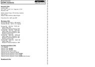
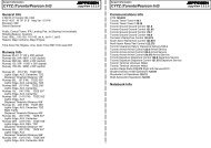
Airport Information<strong>EGPO</strong> (<strong>Stornoway</strong>)JEPPESENJeppView 3.5.2.0General Info<strong>Stornoway</strong>, GBRN 58° 12.9' W 06° 19.9' Mag Var: 7.9°WElevation: 26'Public, Control Tower, IFR, Landing Fee,Customs availble on a restrcted basisFuel: 100LL, Jet A-1Time Zone Info: GMT uses DSTRunway InfoRunway 07-25 3281' x 75' asphaltRunway 18-36 7218' x 151' asphaltRunway 07 (66.0°M) TDZE 26'Lights: Edge, Part timeRight TrafficRunway 18 (181.0°M) TDZE 16'Lights: Edge, ALSDisplaced Threshold Distance 394'Runway 25 (246.0°M) TDZE 21'Lights: Edge, Part timeRunway 36 (1.0°M) TDZE 15'Lights: Edge, ALSRight TrafficCommunications InfoATIS 115.1<strong>Stornoway</strong> Tower 123.5<strong>Stornoway</strong> Approach Control 123.5<strong>Stornoway</strong> Information 123.5 AFISNotebook Info
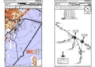
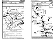
Licensed to max. Printed on 16 Feb 2008.NOTICE: PRINTED FROM AN EXPIRED REVISION. Disc 01-2008<strong>EGPO</strong>/SYYSTORNOWAY*ATIS Apt Elev Alt Set: hPa Trans level: By ATC Trans alt: 3000'26' Direct arrivals are subject to ATC approval.115.1AKIVON59 57.9W009 30.0D28 STND25 STW(IAF)D18 STW10-2JEPPESENJeppView 3.5.2.0STORNOWAY, UK.ARRIVAL.2Descend toat or aboveMSA24 SEP 04JEPPESEN119144^ FL75At or aboveMSADescend toat or above2000'.Eff.30.Sep.090^ 270^1180^ 360^RWY 18 ARRIVAL PROCEDURES2900'3700'2000'MSASTN VOR2100'1 2000' afterpassing STND20 inbound7 5D13 STWN58 24.2 W006 31.9At or above2000'4For LOC DME orNDB approach.181^171^333^R324^11 DME arcSTW42 Request ATC approvalfor direct arc arrival when3within STN 43 DME.Request ATC approval fordirect arrival when withinSTN 30 DME.STORNOWAYD115.1 STN STNN58 12.4 W006 11.0181^2000001^(IAF)STORNOWAYSAY 431 LOC DME(110.9)STWN58 12.9 W006 19.7D7001^R228^NOT TO SCALEN58 12.9 W006 19.7At 2000'4048^3D12 STNN58 03.4 W006 25.8At or aboveMSADescend toat or above2000'D8 STNN58 06.4 W006 20.9At or above2000'CHANGES:LOC DME ident.| JEPPESEN SANDERSON, INC., 2004. ALL RIGHTS RESERVED.Licensed to max. Printed on 16 Feb 2008.NOTICE: PRINTED FROM AN EXPIRED REVISION. Disc 01-2008<strong>EGPO</strong>/SYYSTORNOWAY*ATIS Apt Elev Alt Set: hPa Trans level: By ATC Trans alt: 3000'26' Direct arrivals are subject to ATC approval.115.124 SEP 04JEPPESEN10-2AJEPPESENJeppView 3.5.2.0STORNOWAY, UK.ARRIVAL.090^ 270^1180^ 360^RWY 36 ARRIVAL PROCEDURES.Eff.30.Sep.2900'3700'2000'MSASTN VOR2100'1 2000' afterpassing STND20 inboundSTORNOWAY115.1 STNR127^DN58 12.4 W006 11.0At 3000'R164^087^351^196^216^011^R228^STORNOWAYSAY 431 N58 12.9 W006 19.7LOC DMEN58 12.9 W006 19.7RONARN57 31.8 W005 39.3ULLAPN57 54.0 W005 10.2307^24MSA29MSA181^001^001^D(110.9) SOYD16 SOYN57 58.7 W006 33.43For LOC DME orNDB approach.or as directedbut not belowMSALeave holdingat or above2000'143^323^3(IAF)At or aboveMSADescend toat or above2400'D12 SOYN58 01.8 W006 28.3At or above2400'Descend to1800'At1800'N58 04.1 W006 04.3D12 SOYAt or above1800'(IAF)D17 SOYN58 08.6 W005 58.6D12 SOYAt or aboveMSADescend toat or above1800'(IAF)D17 SOYAt or aboveMSADescend toat or above1800'55344^22 MAX 210 KT afterpassing IAF.(IAF)2STN2At or above1800'2NOT TO SCALE10 DME arc2000SOY200010 DME arc048^SOY4CHANGES:LOC DME ident.| JEPPESEN SANDERSON, INC., 2004. ALL RIGHTS RESERVED.
Licensed to max. Printed on 16 Feb 2008.NOTICE: PRINTED FROM AN EXPIRED REVISION. Disc 01-2008<strong>EGPO</strong>/SYYSTORNOWAY*ATIS Apt Elev Alt Set: hPa Trans level: By ATC Trans alt: 3000'26' Direct arrivals are subject to ATC approval.115.1D14 STNN58 22.1 W006 30.1At 2000'D14 STNN58 23.6 W006 27.0At 2000'12 MAR 04JEPPESEN10-2BRWY 18 INITIAL APPROACHVIA VOR158^181^142R338^.Eff.18.Mar.CAT A & B14JEPPESENJeppView 3.5.2.0STORNOWAY, UK2900'2 For LOC DME orNDB approach..ARRIVAL.180^ 360^2000'090^ 270^3700'2100'1MSASTN VOR1 2000' afterpassing STND20 inboundLicensed to max. Printed on 16 Feb 2008.NOTICE: PRINTED FROM AN EXPIRED REVISION. Disc 01-2008<strong>EGPO</strong>/SYY26'Apt Elev 11 MAR 05 10-9N58 12.9 W006 19.906-22WesternTwyWestapronNorthern Twy(Width 49'/15m)Southern Twy(Width 49'/15m)JEPPESENJeppView 3.5.2.058-13 Western Twy58-13LctrElev 21'109'*ATIS115.106-21Marshalling guidance mandatorywhen using the Eastern apron.CAUTION should be exercisedwhen maneuvering due toproximity of lighting pylons atSouthern edge of Eastern apron.CAUTION should be exercisedusing out of hours permissionwhen SAR helicopter is operating.Rwy 07 & 36 right-hand circuit.143'WARNINGS:Only marked twys to be used.Birds.Pilots should not cross rwy 18displ thresh when lining up fordeparture.Feet010003281'1000m072000 3000 400018181^R5ARPJEPPESENR4Elev26'06-20Elev17'ControlR3 TowerR2R17218' 2200m.Eff.17.Mar.Rwy 07/25 is not available for night landings.Rwy 07/25 is available for acft exceedingMTWA 5700 kg only if crosswind componenton rwy 18/36 exceeds 15 KT or when rwy18/36 is not available.85'EastapronSTORNOWAY, UKSTORNOWAY*STORNOWAY Tower123.5WARNING: Public road crossesunder the approach. Minimumapproach angles indicated byPAPI must be strictly adhered to.Meters 0 500 1000 150058-12 78'58-12N1N206-1925066^ 246^36001^5000Elev15'LMET07^W06-18CAT C & D 321^06-2206-2106-2006-1906-18NOT TO SCALED(IAF)STN330^STORNOWAY115.1 STNN58 12.4 W006 11.0At 3000'or as directedbut not belowMSAdescend to2000'Leave holdingat or above2000'143^2000323^ADDITIONAL RUNWAY INFORMATIONUSABLE LENGTHSLANDING BEYONDRWYThreshold Glide Slope TAKE-OFF WIDTH07 RL (portable) APAPI-L (4.0^)75'25 RL (portable) APAPI-L (3.5^, MEHT 20')23m18151'HIRL HIALS PAPI (3.0^)RVR 6824' 2080m6824' 2080m36 46m.JAR-OPS.LVP must be in Force1All RwysTAKE-OFFCHANGES: New chart.| JEPPESEN SANDERSON, INC., 2004. ALL RIGHTS RESERVED.ABCD1RCLM (DAY only)or RL250m300mRCLM (DAY only)or RL400mOperators applying U.S. Ops Specs: CL required below 300m.CHANGES: Holding points.NIL(DAY only)500m| JEPPESEN SANDERSON, INC., 1999, 2005. ALL RIGHTS RESERVED.
BRIEFING STRIP TMPANS OPS 4Licensed to max. Printed on 16 Feb 2008.NOTICE: PRINTED FROM AN EXPIRED REVISION. Disc 01-2008<strong>EGPO</strong>/SYYJEPPESENSTORNOWAY24 MAR 06 11-1*ATIS *STORNOWAY Approach *STORNOWAY Tower115.1 123.5 123.5LOCFinal Procedure AltMDA(H) Apt Elev 26'STWApch Crs D6.0 STW380'(364')110.9 181^ 2000' (1984')RWY 16'MISSED APCH: Climb STRAIGHT AHEAD to 2000', then turn LEFT toLctr at 2000' to hold, or as directed.58-2058-10ABCD06-40(IAF)STORNOWAYS 431 A SAYY06-30[FL18]001^2000[3.04^][FL18]181^06-20[2~LOC][ML18]D2.0STW[2~LOC] D0.5 STW[ML18]710'JEPPESENJeppView 3.5.2.01 2000' after passingD20.0 STW/D20.0 STN inbound.Gnd speed-Kts70 90 100 120 140 160HIALSDescent gradient 5.30% orPAPI PAPI376 484 538 645 753 861Descent angle [3.04^]MAP at D0.5 STWSTRAIGHT-IN LANDING RWY 18 CIRCLE-TO-LANDMDA(H) 380'(364')ALS outRVR 1200mRVR 1500mRVR 1300mMaxKts100135180205STORNOWAY, UKNDB LOC DME Rwy 1806-10East of Rwy 18/36001^090^180^ 360^106-00[TCH displthresh 50']270^MSA SAY LctrAlt Set: hPa Rwy Elev: 1 hPa Trans level: By ATC Trans alt: 3000'1. LOC DME reads zero at rwy 18 displ thresh. 2. Procedure established outside controlled airspace.3. Lowest altitude to commence procedure from holding is 2000'.857'STW DMEALTITUDE2000'.JAR-OPS.Alternative procedure:D6.5 STW710'RVR 1400m RVR 1800mRVR 1600m1240'433'CHANGES: Circling minimums.5.0958'1680'666'D6.0 STW181^136^316^427'Extend outbound leg of holding toD9.0 STW (CAT C & D: D10.0 STW)descending to 2000', then turn RIGHTto intercept LOC.RVR 2000m522'4.01360'650'4.0181^ 001^814'D6.5 STWD6.0 STWD2.0 STWD0.5 STW3.01040'MDA1.5MDA(H) VIS500'(474') 1500m530'(504') 1600m690'(664')770'(744')LOC DME181^ S 110.9 T WSTW2400m3600m2.0710'0.5Lctr3000'2000'MDA(H) VIS500'(474') 1500m630'(604') 1600m870'(844')2400m1060' (1034') 3600m| JEPPESEN SANDERSON, INC., 2004, 2006. ALL RIGHTS RESERVED.DS2900'3700'STORNOWAY115.1 T STN NRWY 182000'1.0390'2100'16'BRIEFING STRIP TMPANS OPS 4Licensed to max. Printed on 16 Feb 2008.NOTICE: PRINTED FROM AN EXPIRED REVISION. Disc 01-2008<strong>EGPO</strong>/SYYJEPPESENSTORNOWAY24 MAR 06 11-258-20857'58-10ABCDLOCSTW110.906-40*ATIS *STORNOWAY Approach *STORNOWAY Tower115.1 123.5 123.5With R-320 With R-320Minimum AltR-320MDA(H)FinalApt ElevApch Crs1110'(1094') 610'(594')W/o R-320 W/o R-320181^Minimum AltRWYMDA(H)No FAF 1110'(1094')MISSED APCH: Climb STRAIGHT AHEAD to 2000', then turn LEFT toLctr at 2000' to hold, or as directed.Startturn atCAT A & B:3 MinCAT C & D:12 2 MinMAP at Lctr710'1240'433'958'06-30666'136^316^427'Extend outbound leg of holdingfor 3 Min (CAT C & D: 2 1 2 Min)descending to 2000', then turnRIGHT to intercept LOC.MDA(H) 610'(594')ALS out1400mRVR 1500m1500mRVRRVRRVR 1600mRVR 1800m001^522'STRAIGHT-IN LANDING RWY 18With R-320W/o R-3202000181^ 001^181^06-20MDA(H)1110'(1094')ALS outRVR 1500mRVR 1800mRVR 2000m RVR 2000mRVR 2000m814'320^001^W/o R-320East of Rwy 18/36JEPPESENJeppView 3.5.2.0STORNOWAY, UKNDB LOC Rwy 1826'16'Alt Set: hPa Rwy Elev: 1 hPa Trans level: By ATC Trans alt: 3000'.JAR-OPS.Alternative procedure:2000'(IAF)STORNOWAYS 431 A SAYY181^1 After apch w/o R-320: MDA(H) 1110'(1084').CHANGES: Circling minimums.R-320R-3201110'LOC DMES T W06-10Lctr3000'PAPI090^HIALSCIRCLE-TO-LANDMSASAY LctrPAPI06-00270^2000'MaxKts MDA(H) VISMDA(H) VIS100 1 610'(584') 1500m 1 610' (584') 1500m135 1610'(584')1600m 1 630' (604') 1600m11180 690'(664') 2400m 870'(844') 2400m11205 770'(744') 3600m 1060'(1034') 3600m1181^ 110.9 STW3.8180^ 360^12000' afterpassing D20.0 STNinbound.Lowest altitude to commenceprocedure from holding is 2000'.Procedure established outsidecontrolled airspace.| JEPPESEN SANDERSON, INC., 2004, 2006. ALL RIGHTS RESERVED.DS2900'3700'STORNOWAY115.1 T STN NRWY 1816'2000'2100'
BRIEFING STRIP TMLicensed to max. Printed on 16 Feb 2008.NOTICE: PRINTED FROM AN EXPIRED REVISION. Disc 01-2008<strong>EGPO</strong>/SYYJEPPESENSTORNOWAY24 MAR 06 11-3MISSED APCH: Climb STRAIGHT AHEAD to 2000', then turn RIGHTto Lctr at 2000' to hold, or as directed.857'58-10922'58-05LOCSOY110.9*ATIS *STORNOWAY Approach *STORNOWAY Tower115.1 123.5 123.5Final Procedure AltMDA(H) Apt Elev 26'Apch Crs D5.5 SOY350'(335')(1785')RWY710'1240'001^433'958'1800'666'001^2000001^181^181^001^[ML36](IAF)STORNOWAYS 431 A SAYY[2~LO2][FL36]136^316^JEPPESENJeppView 3.5.2.0STORNOWAY, UKNDB LOC DME Rwy 3615'090^180^ 360^1270^MSA SAY LctrAlt Set: hPa Rwy Elev: 1 hPa Trans level: By ATC Trans alt: 3000'1. LOC DME reads zero at rwy 36 threshold. 2. Procedure established outside controlled airspace.3. Lowest altitude to commence procedure from holding is 2000'.58-15D0.5 SOYD2.0 SOYD5.5 SOYD6.0 SOY1 2000' after passingD20.0 SOY/D20.0 STN inbound.LOC DME001^ S 110.9 O YSOYDS2900'3700'2000'STORNOWAY115.1 T STN N2100'BRIEFING STRIP TMLicensed to max. Printed on 16 Feb 2008.NOTICE: PRINTED FROM AN EXPIRED REVISION. Disc 01-2008<strong>EGPO</strong>/SYYJEPPESENSTORNOWAY24 MAR 06 11-4LOCSOY*ATIS *STORNOWAY Approach *STORNOWAY Tower115.1 123.5 123.5With R-235 With R-235Minimum AltR-235MDA(H)FinalApt ElevApch Crs710'(695') 350'(335')W/o R-235 W/o R-235001^Minimum AltRWYMDA(H)No FAF 710'(695')235^JEPPESENJeppView 3.5.2.0STORNOWAY, UKNDB LOC Rwy 3626'15'MISSED APCH: Climb STRAIGHT AHEAD to 2000', then turn RIGHTto Lctr at 2000' to hold, or as directed.Alt Set: hPa Rwy Elev: 1 hPa Trans level: By ATC Trans alt: 3000'857'58-1558-10922'58-05110.9Lowest altitude to commenceprocedure from holding is 2000'.Procedure established outsidecontrolled airspace.710'1240'433'958'666'001^2000001^181^181^R-235(IAF)STORNOWAYS 431 A SAYY090^1180^ 360^LOC DME001^ S 110.9 O YSOYDS2900'3700'2000'1MSASAY Lctr270^2000' afterpassing D20.0STN inbound.STORNOWAY115.1 T STN N2100'001^PANS OPS 406-40[TCH 50']1074'06-30[ML36][2~LO2][3.00^][FL36]Gnd speed-Kts 70 90 100 120 140 160HIALSDescent gradient 5.24%PAPI PAPI372 478 531 637 743 849Descent angle [3.00^]MAP at D0.5 SOYSTRAIGHT-IN LANDING RWY 36 CIRCLE-TO-LAND.JAR-OPS.ABCDRWY 36Lctr3000'15'RVRMDA(H) 350'(335')ALS out900mRVR 1500mRVR 1000mRVR 1400mCHANGES: Circling minimums.181^MDA1.5RVR 1800mRVR 2000m06-20SOY DME 1.0 2.03.04.05.0ALTITUDE380' 700' 1020'1340' 1660'D0.5 SOY0.5D2.0 SOY700'650'MaxKts1001351802053.5001^06-10East of Rwy 18/36MDA(H) VIS500'(474') 1500m530'(504') 1600m690'(664')770'(744')D5.5 SOY2400m3600mD6.0SOY06-002000'MDA(H) VIS500'(474') 1500m630'(604') 1600m870'(844')1800'2400m1060' (1034') 3600m| JEPPESEN SANDERSON, INC., 2004, 2006. ALL RIGHTS RESERVED.PANS OPS 4MAP at LctrABCD106-40RWY 36.JAR-OPS.1074' 06-30Lctr3000'15'181^W/o R-23506-20136^316^001^06-1006-00Startturn atCAT A & B:3 MinCAT C & D:12 2 Min2000'STRAIGHT-IN LANDING RWY 36With R-235W/o R-235MDA(H) 350'(335')MDA(H) 710'(695')CIRCLE-TO-LANDEast of Rwy 18/36RVR 900mMaxALS outALS out Kts MDA(H) VISMDA(H) VISRVR 1200m100 1 500'(474') 1500m 1 500' (474') 1500mRVR 1500mRVR 1500m135 1530'(504')1600m 1 630' (604') 1600mRVR 1000mRVR 1400m1RVR 1800m180 690'(664') 2400m 870'(844') 2400mRVR 2000mRVR 1400m RVR 2000m RVR 1800m205 770'(744') 3600m 1060'(1034') 3600mAfter apch w/o R-235: MDA(H) 710'(684').CHANGES: Circling minimums.3.8R-235710'1800'PAPIHIALSPAPI| JEPPESEN SANDERSON, INC., 2004, 2006. ALL RIGHTS RESERVED.
BRIEFING STRIP TMLicensed to max. Printed on 16 Feb 2008.NOTICE: PRINTED FROM AN EXPIRED REVISION. Disc 01-2008<strong>EGPO</strong>/SYYSTORNOWAYVORSTN*ATIS115.1FinalApch Crs115.1 283^24 MAR 06JEPPESEN13-1*STORNOWAY Approach123.5Minimum Alt MDA(H)VOR2000'(1974')Refer toMinimumsApt Elev 26'MISSED APCH: Climb STRAIGHT AHEAD to 1000', then climbingturn RIGHT to VOR at 2000' or as directed.Alt Set: hPa Apt Elev: 1 hPa Trans level: By ATC Trans alt: 3000'1. WARNING: Due to high ground West of the airfield do remain within appropriatecircling areas according to acft category. 2. Procedure restricted to MAX 210 KT.3. Procedure established outside controlled airspace. 4. Lowest altitude to commenceprocedure from holding is 2000'.JEPPESENJeppView 3.5.2.0STORNOWAY, UKVOR DME*STORNOWAY Tower123.52900'090^180^ 360^3700'2000'MSASTN VOR270^2100'EG(D)-712 ABRIEFING STRIP TMLicensed to max. Printed on 16 Feb 2008.NOTICE: PRINTED FROM AN EXPIRED REVISION. Disc 01-2008<strong>EGPO</strong>/SYYJEPPESENSTORNOWAY24 MAR 06 16-1*ATIS *STORNOWAY Approach *STORNOWAY Tower115.1 123.5 123.5LctrFinal Procedure AltMDA(H) Apt Elev 26'SAYApch Crs D6.0 STW420'(404')431 181^ 2000' (1984')RWY 16'MISSED APCH: Climb STRAIGHT AHEAD to 2000', then turn LEFT toLctr at 2000' to hold, or as directed.136^316^JEPPESENJeppView 3.5.2.0STORNOWAY, UKNDB DME Rwy 18090^180^ 360^270^MSA SAY LctrAlt Set: hPa Rwy Elev: 1 hPa Trans level: By ATC Trans alt: 3000'1. LOC DME reads zero at rwy 18 displ thresh. 2. Procedure established outside controlled airspace.3. Lowest altitude to commence procedure from holding is 2000'.522'814'2900'3700'2000'2100'11 2000' after passingD20.0 STW/D20.0 STN inbound.181^ 001^PANS OPS 458-1558-1058-051074'958'433'06-30APT 26'666'Intermediate approachafter holding 1 Min outbound283^D4.006-20D4.0152^127^283^(IAF)STORNOWAYS T NMHA2000152^115.1 STNVORMSA283^Gnd speed-Kts 70 90 100 120 140 160W/o DME: VOR to MAP 4.0 3:26 2:40 2:24 2:00 1:43 1:30With DME: MAP at D4.0.JAR-OPS.CHANGES: Circling minimums.32D4.0STORNOWAYS 431 A SAYY 2 CAT A & B3CAT C & D143^164^323^(IAF)D9.0283^MSAEast of Rwy 18/36MaxKts MDA(H) VISA 100 500'(474') 1500mB13506-10C & D1127^ A & B152^ C & D530'(504') 1600mC 180 690'(664')D 205 770'(744')1Lighting -Refer toAirportChartCAT A & B:127^20007 DME ArcCIRCLE-TO-LAND2400m3600m2000'120^(IAF)D9.0MSAStartturn atMDA(H) VIS(474') 1500m500'630'9.02000283^By ATC:Direct Arrival via Southeastbetween R-103 and R-164.DME required.Acft unable to receive DMEhave to use main procedurevia holding.06-00CAT A & B:1 2 MinCAT C & D:1 Min1000' 2000' STN115.1RT(604') 1600m870' (844') 2400m1060' (1034') 3600m| JEPPESEN SANDERSON, INC., 2005, 2006. ALL RIGHTS RESERVED.PANS OPS 458-2058-10ABCD857'06-40STW DMEALTITUDE2000'06-30181^001^2000STRAIGHT-IN LANDING RWY 18 CIRCLE-TO-LANDMDA(H) 420'(404')ALS outRVR 1200mRVR 1500mRVR 1300m181^06-20Gnd speed-Kts 70 90 100 120 140 160Descent Gradient 5.2% 369 474 527 632 737 843MAP at D0.5 STW.JAR-OPS.Alternative procedure:RVR 1400m RVR 1800mRVR 1600m427'Extend outbound leg of holding toD9.0 STW (CAT C & D: D10.0 STW)descending to 2000', then turn RIGHTto intercept final.D6.5 STW710'1240'433'CHANGES: Circling minimums.958'666'(IAF)STORNOWAYS 431 A SAYYLOC DME110.9 S T STWW5.01680'D6.0 STW650'4.0RVR 2000mD6.5 STWD6.0 STW4.01360'MaxKts100135180205D2.0 STWD0.5 STWD2.0STW710'MDA1.506-10East of Rwy 18/36001^MDA(H) VIS500'(474') 1500m530'(504') 1600m690'(664')770'(744')3.01040'D0.5 STW2400m3600m0.5Lctr3000'PAPIHIALSPAPI06-002000'MDA(H) VIS500'(474') 1500m630'(604') 1600m870'(844')2400m1060' (1034') 3600m| JEPPESEN SANDERSON, INC., 1999, 2006. ALL RIGHTS RESERVED.DSSTORNOWAY115.1 T STN N2.0710'RWY 1816'
BRIEFING STRIP TMPANS OPS 4Licensed to max. Printed on 16 Feb 2008.NOTICE: PRINTED FROM AN EXPIRED REVISION. Disc 01-2008<strong>EGPO</strong>/SYYJEPPESENSTORNOWAY24 MAR 06 16-258-20857'58-10LctrSAY06-40*ATIS *STORNOWAY Approach *STORNOWAY Tower115.1 123.5 123.5With R-320 With R-320Minimum AltR-320MDA(H)FinalApt ElevApch Crs1110'(1094') 610'(594')W/o R-320 W/o R-320Minimum AltRWYMDA(H)No FAF 1110'(1094')431 181^MISSED APCH: Climb STRAIGHT AHEAD to 2000', then turn LEFT toLctr at 2000' to hold, or as directed.Startturn atCAT A & B:3 MinCAT C & D:12 2 Min710'1240'433'958'136^316^(IAF)STORNOWAYS 431 A SAYY06-30666'427'Extend outbound leg of holdingfor 3 Min (CAT C & D: 2 1 2 Min)descending to 2000', then turnRIGHT to intercept final.001^522'2000181^ 001^181^06-20814'320^001^W/o R-320JEPPESENJeppView 3.5.2.0STORNOWAY, UKNDB Rwy 1826'16'Alt Set: hPa Rwy Elev: 1 hPa Trans level: By ATC Trans alt: 3000'181^06-10Lctr3000'PAPIHIALSMSASAY LctrPAPI06-002000'MAP at LctrSTRAIGHT-IN LANDING RWY 18CIRCLE-TO-LANDWith R-320W/o R-320MDA(H) 610'(594') MDA(H)1110'(1094')East of Rwy 18/36MaxALS outALS out Kts MDA(H) VISMDA(H) VISA RVR 1400m100 1 610'(584') 1500m 1 610' (584') 1500mRVR 1500mRVR 1500mB RVR 1500m135 1610'(584')1600m 1 630' (604') 1600mC11RVR 1600mRVR 1800m180 690'(664') 2400m 870'(844') 2400mRVR 2000m RVR 2000m11D RVR 1800mRVR 2000m205 770'(744') 3600m 1060'(1034') 3600m.JAR-OPS.Alternative procedure:2000'1 After apch w/o R-320: MDA(H) 1110'(1084').CHANGES: Circling minimums.R-320R-3201110'3.8090^180^ 360^1270^1 2000' afterpassing D20.0inbound.Lowest altitude to commenceprocedure from holding is 2000'.Procedure established outsidecontrolled airspace.| JEPPESEN SANDERSON, INC., 2004, 2006. ALL RIGHTS RESERVED.DS2900'3700'STORNOWAY115.1 T STN NRWY 1816'2000'2100'BRIEFING STRIP TMPANS OPS 4Licensed to max. Printed on 16 Feb 2008.NOTICE: PRINTED FROM AN EXPIRED REVISION. Disc 01-2008<strong>EGPO</strong>/SYYJEPPESEN24 MAR 06STORNOWAY 16-3MISSED APCH: Climb STRAIGHT AHEAD to 2000', then turn RIGHTto Lctr at 2000' to hold, or as directed.857'58-10922'58-05LctrSAY06-40*ATIS *STORNOWAY Approach *STORNOWAY Tower115.1 123.5 123.5Final Procedure AltMDA(H) Apt Elev 26'Apch Crs D5.5 SOY390'(375')(1785')RWY710'1240'1074'001^433'958'06-301800'666'001^2000001^181^181^001^06-20136^316^06-10JEPPESENJeppView 3.5.2.0STORNOWAY, UKNDB DME Rwy 3615'090^180^ 360^106-00270^MSA SAY LctrAlt Set: hPa Rwy Elev: 1 hPa Trans level: By ATC Trans alt: 3000'1. LOC DME reads zero at rwy 36 threshold. 2. Procedure established outside controlled airspace.3. Lowest altitude to commence procedure from holding is 2000'.Gnd speed-Kts 70 90 100 120 140 160Descent Gradient 5.2% 369 474 527 632 737 843MAP at D0.5 SOYABCD58-15431RWY 36.JAR-OPS.Lctr3000'15'RVR1 2000' after passingD20.0 SOY/D20.0 STN inbound.STRAIGHT-IN LANDING RWY 36 CIRCLE-TO-LANDMDA(H) 390'(375')ALS out900mRVR 1500mRVR 1000mRVR 1400mCHANGES: Circling minimums.LOC DMES 110.9 O SOYY181^RVR 1800mRVR 2000mMaxKts100135180205(IAF)STORNOWAYS 431 A SAYY001^East of Rwy 18/36MDA(H) VIS500'(474') 1500m530'(504') 1600m690'(664')770'(744')2400m3600mPAPIHIALSPAPI2000'MDA(H) VIS500'(474') 1500m630'(604') 1600m870'(844')2400m1060' (1034') 3600m| JEPPESEN SANDERSON, INC., 2004, 2006. ALL RIGHTS RESERVED.DS2900'3700'2000'STORNOWAY115.1 T STN NSOY DME 2.03.04.05.0ALTITUDE700'1020'1340' 1660'D0.5 SOY0.51020'MDA2.5D3.0 SOYD0.5 SOYD3.0 SOYD5.5 SOYD6.0 SOY900'2.5D5.5 SOYD6.0SOY1800'2100'
BRIEFING STRIP TMLicensed to max. Printed on 16 Feb 2008.NOTICE: PRINTED FROM AN EXPIRED REVISION. Disc 01-2008<strong>EGPO</strong>/SYYJEPPESENSTORNOWAY24 MAR 06 16-4LctrSAY431*ATIS *STORNOWAY Approach *STORNOWAY Tower115.1 123.5 123.5With R-235 With R-235Minimum AltR-235MDA(H)FinalApt ElevApch Crs720'(705') 390'(375')W/o R-235 W/o R-235001^Minimum AltRWYMDA(H)No FAF 720'(705')JEPPESENJeppView 3.5.2.0STORNOWAY, UKNDB Rwy 3626'15'MISSED APCH: Climb STRAIGHT AHEAD to 2000', then turn RIGHTto Lctr at 2000' to hold, or as directed.Alt Set: hPa Rwy Elev: 1 hPa Trans level: By ATC Trans alt: 3000'090^12900'180^ 360^3700'2000'1MSASAY Lctr270^2100'2000' afterpassing D20.0inbound.857'58-15Lowest altitude to commenceprocedure from holding is 2000'.Procedure established outsidecontrolled airspace.710'958'666'2000001^181^(IAF)STORNOWAYS 431 A SAYYDSSTORNOWAY115.1 T STN N001^1240'181^235^58-10433'R-235001^922'58-0506-401074'Lctr3000'06-30181^W/o R-23506-20R-235720'136^316^001^06-101800'06-00Startturn atCAT A & B:3 MinCAT C & D:12 2 MinRWY 3615'3.8HIALSPAPI PAPI2000'PANS OPS 4MAP at Lctr.JAR-OPS.ABCD1MDA(H) 390'(375')ALS out900mRVR 1500mRVRRVR 1000mRVR 1400mSTRAIGHT-IN LANDING RWY 36With R-235W/o R-235RVR 1800mRVR 2000mAfter apch w/o R-235: MDA(H) 720'(694').CHANGES: Circling minimums.CIRCLE-TO-LANDEast of Rwy 18/36MDA(H) 720'(705')MaxALS out Kts MDA(H) VISMDA(H) VISRVR 1200m100 1 500'(474') 1500m 1 500' (474') 1500mRVR 1500m135 1530'(504')1600m 1 630' (604') 1600mRVR 1400m1180 690'(664') 2400m 870'(844') 2400mRVR 2000mRVR 1800m205 770'(744') 3600m 1060'(1034') 3600m| JEPPESEN SANDERSON, INC., 2004, 2006. ALL RIGHTS RESERVED.