Planning Schedule Date: 10/08/2004 - Stroud District Council
Planning Schedule Date: 10/08/2004 - Stroud District Council
Planning Schedule Date: 10/08/2004 - Stroud District Council

Create successful ePaper yourself
Turn your PDF publications into a flip-book with our unique Google optimized e-Paper software.
<strong>Planning</strong> <strong>Schedule</strong> <strong>Date</strong>: <strong>10</strong>/<strong>08</strong>/<strong>2004</strong><br />
and would not cause harm to the character and appearance of that part of the settlement; the<br />
density proposed is at as high a level as is acceptable in townscape and amenity terms; the<br />
development includes dwellings of various sizes, both in respect of physical size and type; it<br />
would not cause the loss of, or damage to, features of characteristic value; and where dwellinghouses<br />
are proposed, an appropriate area of private amenity space is provided for the occupiers<br />
of each dwelling-house. Where other types of residential accommodation are proposed, an<br />
appropriate level of amenity space to serve the scheme as a whole is provided; and important<br />
views into and out of the site are protected. Policy T1 requires that appropriate levels of parking<br />
are provided in accordance with the <strong>Council</strong>'s adopted standards and may require traffic calming<br />
or highway improvements were relevant. The development will not directly affect the historic<br />
route of the canal and the relevant section of Policy R8 and requires that development relates to<br />
the canal setting. Policy G4 will not permit development on land liable to flood or where it would<br />
increase the risk of flooding. The other policies seek to ensure that no detrimental effects result<br />
either on highway safety or the amenities of the occupiers of neighbouring properties.<br />
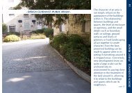
In and close to <strong>Stroud</strong> Town Centre the character of the canal corridor is that hard edge, built<br />
form abuts close to both sides of the canal. As you move in a westerly direction along the canal<br />
the proportion of built form decreases, and the relationship with open spaces and vegetation<br />
becomes more important. More specifically once you leave Wallbridge area there is built form to<br />
the southern side interspersed with significant open /soft landscaped areas with sporadic<br />
development to the north. Once the canal passes under the Dudbridge Road, the openness of<br />
the corridor has already been significantly enclosed by the Bridgeside Estate and further to the<br />
west by the more recent Chelbury and Bryant Homes developments. These recent<br />
developments have very significantly increased the hard edge of the canal corridor in this vicinity<br />
increasing the relative importance of those remaining open/landscaped parcels of land. The<br />
perception of the area with the proposed development would be hard built form along the entire<br />
side of this part of the canal, which is not in keeping with the more rural character of the<br />
surroundings (away from the ribbon development on the roads). This harm is exacerbated by the<br />
canal edge development being a substantial two and a half storey building with a historically<br />
uncharacteristic plan width, which results in a large dominating structure. The proposal would<br />
harm the character of this section of the canal corridor contrary to criteria 1, 5 & 6 of Policy H14<br />
and criteria 1, 2 and 3 of Policy B4. Concern is also expressed in the loss of views that would<br />
result from the canal corridor up to historic properties to the north, while these are not listed many<br />
are important character buildings in the vicinity. The proposal results in harm to views out of the<br />
canal corridor and its relationship to these buildings contrary to criteria 4 of Policy B4.<br />
The proposal would relate differently to the canal than the neighbouring development and refusal<br />
would not be warranted due to Policy R8. No response has been received from County<br />
Highways regarding the access to the site and highway safety. This response should be<br />
available and verbally presented at the committee meeting, and as such no comment is made<br />
regarding highway safety and Policy G5 at this stage. The proposed development is set at a<br />
lower level than those neighbouring properties fronting onto Westward Road, such that the<br />
proposal would have no significant affect on the amenities of their occupiers. Further the<br />
orientation and distance from other properties would not result in significant effects either by<br />
dominating effect, loss of light or privacy on the amenities of the occupiers of neighbouring<br />
properties in accordance with Policy G1.<br />
The Environment Agency state the site is within an area at 'high risk of flooding'. As the<br />
application is not supported by a Flood Risk Assessment the Agency objects as it may increase<br />
the risk that future residents will be cut off from dry land, place extra strain on emergency<br />
services and put lives at risk, contrary to Policy G4.<br />
Refusal is recommended.<br />
In compiling this recommendation we have given full consideration to all aspects of the Human<br />
Rights Act 1998 in relation to the applicant and/or the occupiers of any neighbouring or affected<br />
<strong>10</strong>2