

GIS Sana Sini - Malaysia Geoportal
GIS Sana Sini - Malaysia Geoportal
GIS Sana Sini - Malaysia Geoportal
- No tags were found...

Create successful ePaper yourself
Turn your PDF publications into a flip-book with our unique Google optimized e-Paper software.
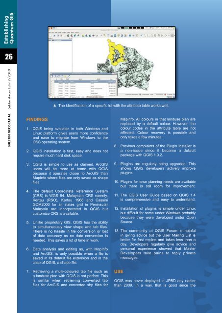
EstablishingQuantum <strong>GIS</strong>26BULETIN GEOSPATIAL Sektor Awam Edisi 2/2010FINDINGSThe identification of a specific lot with the attribute table works well.1. Q<strong>GIS</strong> being available in both Windows andLinux platform gives users more confidenceand ease to migrate from Windows to theOSS operating system.2. Q<strong>GIS</strong> installation is fast, easy and does notrequire much hard disk space.Mapinfo. All colours in that landuse plan arereplaced by a default colour. However, thecolour codes in the attribute table are notaffected. Colour recovery is possible andonly takes a few minutes.8. Previous complaints of the Plugin Installer isa non-issue since it became a defaultpackage with Q<strong>GIS</strong> 1.0.2.3. Q<strong>GIS</strong> is simple to use as claimed. Arc<strong>GIS</strong>users will be more at home with Q<strong>GIS</strong>because it operates closer to Arc<strong>GIS</strong> thanMapInfo where files are only saved as shapefiles.4. The default Coordinate Reference System(CRS) is WGS 84. <strong>Malaysia</strong>n CRS namely,Kertau (RSO), Kertau 1968 and CassiniGDM2000 for all states grid in Peninsular<strong>Malaysia</strong> are incorporated in Q<strong>GIS</strong> butcustomize CRS is available.5. Unlike proprietary <strong>GIS</strong>, Q<strong>GIS</strong> has the abilityto simultaneously view shape and tab files.There is no hassle in file conversion or lostof data accuracy as no data conversion isneeded. This saves a lot of time in work.6. Data analysis and editing as, with MapInfoand Arc<strong>GIS</strong>, is only possible when a file issaved in its default file extension and in thecase of Q<strong>GIS</strong>, a shape file.7. Retrieving a multi-coloured tab file such asa landuse plan with Q<strong>GIS</strong> is not perfect. Thisis similar when retrieving converted tabfiles for Arc<strong>GIS</strong> and converted shp files for9. Plugins are regularly being upgraded. Thisshows Q<strong>GIS</strong> developers actively improveplugins.10. Plugins for town planning needs are availablebut there is still room for improvement.11. The Q<strong>GIS</strong> User Guide based on Q<strong>GIS</strong> 1.4is comprehensive and easy to understand.12. Installation of plugins is simple under Linuxbut difficult for some under Windows probablybecause they were developed under OpenSource.13. The community at Q<strong>GIS</strong> Forum is helpfulin giving advice but the User Mailing List isbetter for fast replies and takes less than aday. Developers regularly give advice andpersonal experience showed that MasterDevelopers take pains to reply privatemessages.USEQ<strong>GIS</strong> was never deployed in JPBD any earlierthan 2009. In a way, that is good since the


