Llanarmon Dyffryn Ceiriog Conservation Area Assessment and ...
Llanarmon Dyffryn Ceiriog Conservation Area Assessment and ...
Llanarmon Dyffryn Ceiriog Conservation Area Assessment and ...

You also want an ePaper? Increase the reach of your titles
YUMPU automatically turns print PDFs into web optimized ePapers that Google loves.
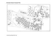
contentsPart I - Character <strong>Assessment</strong>1.0 Introduction2.0 History <strong>and</strong> Development3.0 Summary of Special Character4.0 Character in Detail5.0 Summary of Negative Features13581017Part II - Management Plan6.0 Enhancement Plan7.0 Design Guidance8.0 <strong>Conservation</strong> <strong>Area</strong> Controls9.0 Sources of Funding1920222426Appendix 1Listed Buildings27Appendix 2<strong>Conservation</strong> Policy Guidance28Appendix 3Glossary of Architectural Terms29FiguresFigure 1 - <strong>Llanarmon</strong> <strong>Dyffryn</strong> <strong>Ceiriog</strong> <strong>Conservation</strong> <strong>Area</strong>Figure 2 - <strong>Llanarmon</strong> <strong>Dyffryn</strong> <strong>Ceiriog</strong>, 1875Figure 3 - <strong>Llanarmon</strong> <strong>Dyffryn</strong> <strong>Ceiriog</strong>, Character Map4611
Part 1Character <strong>Assessment</strong>1
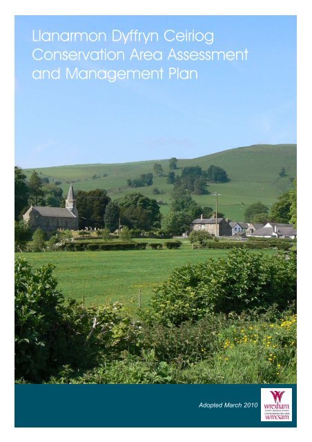
introduction<strong>Conservation</strong> <strong>Area</strong> Designation1.1 Section 69 of the Planning (Listed Buildings <strong>and</strong><strong>Conservation</strong> <strong>Area</strong>s) Act 1990 requires Local Authorities toidentify "areas of special architectural or historic interest thecharacter or appearance of which it is desirable to preserve orenhance" for designation as conservation areas.Purpose1.2 The purpose of <strong>Conservation</strong> <strong>Area</strong> <strong>Assessment</strong> <strong>and</strong> Management Plan is:●●●●●To provide a clear definition of an area's special architectural or historic interestTo identify ways in which its unique characteristics can be preserved <strong>and</strong> enhanced through the Enhancement PlanTo strengthen the justification for designationTo create a clear context for future development in accordance with conservation area policies in the development planTo provide a vehicle for engagement <strong>and</strong> awareness raising<strong>Llanarmon</strong> <strong>Dyffryn</strong> <strong>Ceiriog</strong><strong>Conservation</strong> <strong>Area</strong>1.3 This <strong>Assessment</strong> <strong>and</strong> Management Plan aims to promote<strong>and</strong> support developments that are in keeping with, or enhance,the character of the <strong>Llanarmon</strong> <strong>Dyffryn</strong> <strong>Ceiriog</strong> <strong>Conservation</strong><strong>Area</strong>. It is not an attempt to stifle change. The aim is to strike abalance so that the interests of conservation are given their fullweight against the needs for change <strong>and</strong> development. The<strong>Llanarmon</strong> <strong>Dyffryn</strong> <strong>Ceiriog</strong> <strong>Conservation</strong> <strong>Area</strong> was firstdesignated on 29 August 1975 <strong>and</strong> its boundary amended inFebruary 2000. This document is largely concerned with the1 introductionreasons for designation, defining the qualities that make up itsspecial architectural <strong>and</strong> historic interest, character <strong>and</strong>appearance. The omission of any reference to a particularbuilding, feature or space should not be taken to imply that it isof no interest.Planning Context1.4 This Statement should be read in conjunction with theadopted Wrexham Unitary Development Plan 2005, <strong>and</strong> nationalplanning policy guidance, in particular Welsh Office Circular61/96 Planning <strong>and</strong> the Historic Environment: Historic Buildings<strong>and</strong> <strong>Conservation</strong> <strong>Area</strong>s.Location1.5 <strong>Llanarmon</strong> <strong>Dyffryn</strong> <strong>Ceiriog</strong> is approximately 15km (9miles) south west of Chirk on the B4500 road. It is 11km(7miles) south west of Llangollen <strong>and</strong> 14km (9 miles) to thewest of Oswestry. The village lies almost at the head of the<strong>Ceiriog</strong> valley, approximately 870 feet above sea level in thefolds of the Berwyn Mountains. The <strong>Conservation</strong> <strong>Area</strong>encompasses the historic village centre.Geology1.6 <strong>Llanarmon</strong> <strong>Dyffryn</strong> <strong>Ceiriog</strong> is set within the upl<strong>and</strong> pastureof the <strong>Ceiriog</strong> Valley, cut through by the River <strong>Ceiriog</strong>. Theunderlying geology is that of the Berwyn Dome; a mixture ofOrdovician sedimentary silt-stones <strong>and</strong> mud-stones, which formthe principal building material of the area.Consultation1.7 Community Councils, Council members <strong>and</strong> a range oforganisations <strong>and</strong> groups with an interest in the historicenvironment <strong>and</strong> the local area were consulted on this document.Statutory bodies such as Cadw were also consulted. Publicconsultation was undertaken during December 2009 <strong>and</strong> January2010. Members of the public were invited to discuss theproposals with the <strong>Conservation</strong> Officer at the <strong>Llanarmon</strong><strong>Dyffryn</strong> <strong>Ceiriog</strong> Village Hall.3
introductionOrdnance Survey (mapping) © Crown copyright. All rights reserved. 100023429. 20104
history <strong>and</strong> development2 History <strong>and</strong> Development2.1 The history of <strong>Llanarmon</strong> suggests that from ancienttimes the village <strong>and</strong> its surrounding l<strong>and</strong>scape was a suitablelocation for food, shelter <strong>and</strong> defence. A stone axe from theMesolithic or Middle Stone Age period (8000 - 4300 BC) wasfound approximately three miles north west of the village. Alater Bronze Age axe head (2300 - 600BC) was also found,which may have been used for hunting purposes. An Iron Agesettlement (600BC - AD 43) slightly closer to the village has anearth fortification called Cerrig Gwynion (white stones) on awhite quartz feldspar outcrop with some evidence ofroundhouses remaining. Also discovered nearby were severalRoman coins dating from AD43 - 410.2.2 <strong>Llanarmon</strong> is a Welsh word which translates into Englishas 'The Parish ofGermanus'.<strong>Dyffryn</strong> <strong>Ceiriog</strong>means 'in thevalley of the<strong>Ceiriog</strong>'.Archaeologicalevidencesuggests that thecurrent villageof <strong>Llanarmon</strong><strong>Dyffryn</strong> <strong>Ceiriog</strong>began as a druid settlement which in the 5th century cameunder the leadership of Germanus, Bishop of Auxerre, (C378 448 AD), a French Christian monk <strong>and</strong> soldier who came toBritain in 429 AD to establish Christianity. He might havebeen responsible for other Christian cells in North Wales, suchas <strong>Llanarmon</strong> Mynydd Mawr, near Conwy <strong>and</strong> <strong>Llanarmon</strong> ynIal, near Ruthin. All are situated on valley slopes with achurch, cemetery <strong>and</strong> living quarters, <strong>and</strong> in <strong>Llanarmon</strong><strong>Dyffryn</strong> <strong>Ceiriog</strong> there is also a preaching mound, TomenGarmon, which is located in the current churchyard.2.3 The 12th <strong>and</strong> 13th Centuries brought about much change<strong>and</strong> unrest in North Wales as a result of the Norman Conquest<strong>and</strong> Edward I. Neither was able to penetrate the valley. TheNormans swept into the coastal areas of North Wales by thelate 11th Century after their triumphant invasion of Britain in1066. In the middle of the 12th century, they defeated theWelsh at Chirk, constructing a motte on the edge of the Deevalley to the south of St Mary's Church. This was sited tocontrol access up the valley.2.4 Henry II (1154-1189), King of Engl<strong>and</strong> <strong>and</strong> half ofpresent day France attempted to invade <strong>and</strong> conquer the Welshfor final subjugation in the valley in 1165. His army wasassembled at Shrewsbury, <strong>and</strong> then marched to a base atOswestry Castle before advancing to the <strong>Ceiriog</strong> Valley.Henry's mercenaries were attacked at various points en routethrough the valley, notably by Owain Gwynedd. The fightingfury of the Welsh <strong>and</strong> the lack of basic supplies plus terribleweather conditions, particularly around the boggy ground ofNantyr, meant that the expedition was hampered. In a rageHenry ordered his army to Chester, where his Welsh hostageswere blinded <strong>and</strong> castrated.2.5 Even the warlord Edward I was unsuccessful in his questto conquer the Welsh. His army managed only to conquerChirk, which wasbequeathed in 1272to Roger Mortimerof Wigmore.Mortimersubsequently builtthe new ChirkCastle between1295 <strong>and</strong> 1310, amile to the west ofthe Norman motte.Chirk Castle does not appear to have been placed in5
history <strong>and</strong> developmentFigure 2: <strong>Llanarmon</strong> <strong>Dyffryn</strong> <strong>Ceiriog</strong> Historic Map 1875Ordnance Survey (mapping) © Crown copyright. All rights reserved. 100023429. 2010a strategic military site, however its original gateway faced westto the <strong>Ceiriog</strong> valley, so any Welshman would be immediatelyaware of Chirk's allegiance to the English crown.2.6 Whilst wars were raging however, religion was important.The Cistercian order built 76 monasteries around Britain, the lastbeing at Valle Crucis near Llangollen in 1202. The religious cellat <strong>Llanarmon</strong>, originally dedicated to <strong>and</strong> related to Valle Crucis,became the chapelry to the mother church of St Mary's inChurch Street in Chirk, which serviced the Norman fort at Chirk.The first written record of the village is found in the Norwichtaxation of 1254 for 'Capella de Llangarnayan', a taxation onecclesiastical property in the 11th century.2.7 It was not until the 18th century that further documentaryevidence of the village surfaced. An Estate Map of c1760depicts a small village built around a crossroads. The oldestbuilding in the village today is reputed to be the West ArmsHotel, built in the 1600s <strong>and</strong> formerly known as the Eagle Inn.An Ordance Survey benchmark on the front of the building is ata height of 870 feet above sea level. The H<strong>and</strong> Hotel is alsovery old, used as both a farm <strong>and</strong> inn until the early 20thcentury. The village served as a regular halting place for droversin the days when cattle were taken to London by foot; itdeveloped organically during the 18th <strong>and</strong> 19th century, withagriculture the primary source of employment. In the mid 19thcentury the medieval church at <strong>Llanarmon</strong> was destroyed by theVictorians, who built a new one in its place. When the churchwas demolished a hoard of 15th century coins was found, whichare now in the British Museum.2.8 George Borrow, the 19th Century travel writer visited thevalley <strong>and</strong> <strong>Llanarmon</strong> <strong>and</strong> wrote in his account of 'Wild Wales'(1854): "I reached <strong>Llanarmon</strong>, another small village, situated in a valley6through which the <strong>Ceiriog</strong> flows. It is halfway betweenLlangollen <strong>and</strong> Rhaeadr, being ten miles from each. I went to asmall inn, sat down <strong>and</strong> called for ale. A waggoner was seatedat a large table with a newspaper before him on which he wasstarting intently. "What news?" said I in English. "I wish I couldtell you" he said in very broken English, "but I cannot read".2.9 However, for the children of <strong>Llanarmon</strong>, literacy <strong>and</strong>numeracy had been addressed. The Church of Engl<strong>and</strong> Nationalschool was created in 1833, for both boys <strong>and</strong> girls, whichtaught both in Welsh <strong>and</strong> English. In 1847 <strong>Llanarmon</strong> ChurchSchool was built. It was at this school that the Welsh poet<strong>Ceiriog</strong> was taught. A British school under the Quaker Bodyacting for the non-conformists opened its first school in 1870.2.10 The biggest threat to the way of life in the valley was in1922. Warrington Corporation required an improved watersupply <strong>and</strong> storage for Merseyside, <strong>and</strong> their proposal was toflood the upper <strong>Ceiriog</strong> valley of about 13,600 acres. A numberof valleys in both Engl<strong>and</strong> <strong>and</strong> Wales were flooded for thepurpose of supplying burgeoning conurbations with water, but inthis valley it stoked up more than usual racial resentmentbetween Wales <strong>and</strong> Engl<strong>and</strong>, <strong>and</strong> threatened to dispossesshundreds of people, some of whom had ancestry in the areadating back centuries. It also threatened to submerge Dolwen,reputed to be the former home of C12th Welsh Prince, OwainGwynedd. If the project had been successful it would haveinvolved the construction of two lakes, one on either side of<strong>Llanarmon</strong>. The corporation announced its intention of acquiringvirtually all the property in the village <strong>and</strong> adjoining parts of thevalley, which included one church, five chapels, two post offices,five shops <strong>and</strong> a blacksmith's forge, plus eighty two otherdwellings, of which forty five were farm houses <strong>and</strong> farmbuildings. Fortunately however, after a visit by the British PrimeMinister, David Lloyd George, who stated that the valley
history <strong>and</strong> developmentwas 'A little bit of Heaven on Earth, which must be preservedat all costs' ("Darn bach o nefoedd ar y ddaear"), alternativeproposals were eventually put forward <strong>and</strong> the valley wassaved.2.11 Today the village has a low key but thriving tourismindustry for walkers <strong>and</strong> shooting parties. All of the historicshops <strong>and</strong> services have gone, with the exception of theschool <strong>and</strong> community centre, due presumably to better roadlinks <strong>and</strong> increased mobility of the community. Some smallscale development has occurred in the village in recent years,but due to its relative remoteness, the character of the arearemains largely unchanged.7
summary of special character3 Summary of Special Character3.1 <strong>Llanarmon</strong> is a particularly picturesque village with a senseof orderly serenity, <strong>and</strong> a strong community, located in a valleywhich is enriched by mountainous view points, hidden paths,linear settlements <strong>and</strong> isolated farmsteads, <strong>and</strong> narrow roads.Topography3.2 <strong>Llanarmon</strong> has developed in a linear pattern to an areaknown as Nanty Glôg alongthe mountainroad toLlanrhaeadr ymMochnantwhich follows atributary toAfon <strong>Ceiriog</strong> on a mountainslope rising upfrom the villageto the south <strong>and</strong>providing important views within <strong>and</strong> from the village. Thetopography of the village relates to the valley plateau in theBerwyns. The <strong>Ceiriog</strong> is a significant l<strong>and</strong>scape feature,demarcating the settlement boundary to the north, <strong>and</strong> enrichingthe setting of the village. The <strong>Conservation</strong> <strong>Area</strong> is the compactvillage centre.Vernacular Detail3.3 Buildings are mostly constructed of the local stone incourses <strong>and</strong> either rendered or whitewashed. Buildings tend tobe linear in plan with low eaves, although with some notableexceptions, such as the West Arms Hotel. The roof-scape is veryimportant to the overall appearance of the area with gable endsbeing a prominent feature, seen staggering up the hill when8viewed from the north upon entering the village. Chimneystackswere probably originally built of stone but most havebeen rebuilt with clay bricks. Buildings are of an intimate scale,even the spire to the churchbeing of a shortened design,allowing trees rather thanbuildings to dominate theskyline. Façades are simplydetailed, with window <strong>and</strong>doors providing theessential architecturaldetail. Most ground <strong>and</strong>first floor windows tend toalign with each otheralthough older propertieshave a more r<strong>and</strong>omarrangement. The amountof solid wall isproportionately greater thanvoid i.e. windows <strong>and</strong> doors, giving buildings a robustappearance.Boundary Walls3.4 Stone walls, both dry-stone <strong>and</strong> mortar-bedded, areimportant boundary features within the area creating a strongstreet frontage <strong>and</strong>sense of enclosure.
summary of special characterOrganic Building Layout3.5 Within the village centre, the majority of buildingsdirectly front untothe road, the greaternumber tending todate from the 17thCentury onwards.The settlementpattern within the<strong>Conservation</strong> <strong>Area</strong> ishowever organic <strong>and</strong>comprises a mix ofhouse types, such aslarger, detached buildings with fairly extensive rear curtilages,<strong>and</strong> half storey outbuildings, of local stone with pitched slateroofs. Cottages are mostly terraced in narrow plot widths withsmall gardens. Important boundaries comprise a mixture ofhistoric dry stone walling <strong>and</strong> hedgerows.Village Square3.6 There is no formal public space within the conservationarea. The central point of the village is the informal opensquare at the crossroads from which the narrow roads lead tothe north, south, east <strong>and</strong> west.Trees <strong>and</strong>GreenSpace3.7 Green spaceswithin theconservation arearelate principally toenclosed buildingplots, the surrounding hills <strong>and</strong> the riverbanks. Trees,particularly along the road leading to the river, are importantl<strong>and</strong>scaping features easing the transition between the built <strong>and</strong>natural environment as well as defining the village centre. Anumber of public footpaths lead off from the village into thesurrounding countryside.L<strong>and</strong>mark buildings3.8 Situated approximately north, south, east <strong>and</strong> west of thevillage square, l<strong>and</strong>mark buildings comprise the Church of StGarmon, the H<strong>and</strong> Hotel, the Tabernacle chapel <strong>and</strong> the WestArms Hotel.9
character in detail4 Character in Detail4.1 Approaching the village from Glyn <strong>Ceiriog</strong>, the Church ofSt Garmon appears as a distant l<strong>and</strong>mark to the east of thevillage centre, nestled at the foot of the mountainside. Thevillage is entered along a wide road over an early 20th centurybridge, the flanking walls <strong>and</strong> stone abutment piers framing thevillage ahead <strong>and</strong> in particular the prominent H<strong>and</strong> Hotel.Beyond this the mountains rise up behind, with green pasture<strong>and</strong> many mature trees providing a backdrop to the village <strong>and</strong>affording it its picturesque setting.4.2 The river crossing is the only point of entry to the villagefrom the north of the <strong>Ceiriog</strong> Valley. The original double archedstone bridgeknown as PontFawr, the bigbridge, wasreplaced by thepresent bridge in1909, at whichtime the roadwas widened.This bridge, isconstructed oftwo spans ofsteel joists supported on s<strong>and</strong>stone abutments <strong>and</strong> a single pier atmidstream. The bridge deck is of concrete <strong>and</strong> the parpet is ofsteel; the s<strong>and</strong>stone piers have concrete pyramidal cappings.Trees on the riverbank adjacent the bridge frame the view of thevillage <strong>and</strong> together with the stone walls which line the routeinto the village, create a strong sense of arrival.4.3 After crossing the bridge, the Neuadd Ganmlwydd ('the<strong>Ceiriog</strong> Centenary Hall') is situated on the left <strong>and</strong> is reachedover a small stream, the Nant Gwrachen, Gwrachen meaning'crooked or me<strong>and</strong>ering', which runs down through the village to10the river. The NantGwrachen is a naturalfeature within the builtenvironment thatcontributes to thefeeling of tranquillityin both its movement<strong>and</strong> sound. Theentrance to the hallhas one stone pierwith pyramidal capping similar to those on the bridge. The hallitself is a fairly substantial building originally linear in plan ithas been extended at a right angle from its eastern gable <strong>and</strong> onthe north side; the roof covering is natural slate. The originalstructure is built of r<strong>and</strong>om, uncoursed stonework with brownbrick window jambs <strong>and</strong> quoins <strong>and</strong> segmental arched windowheads of local slates <strong>and</strong> emphasised keystones. This part of thebuilding has traditional vertically sliding sash windows. Eightfoundation plaques bear the names of several Welsh societiesincluding those in Manchester, London <strong>and</strong> Liverpool, <strong>and</strong>colleges <strong>and</strong> schools in Wales.The extension is modern <strong>and</strong>constructed of brown brick witha contrasting render finish <strong>and</strong>side hung casement windowscreating a distinction betweenthe new <strong>and</strong> the originalconstruction. A row ofsycamore trees <strong>and</strong> a largebeech, to the frontage of the sitegive a strong sense of identity tothe village approach <strong>and</strong>contribute to the setting of thehall.
Figure 5: <strong>Llanarmon</strong> <strong>Dyffryn</strong> <strong>Ceiriog</strong> Character <strong>Area</strong><strong>Conservation</strong> <strong>Area</strong>character in detailListed BuildingsImportant ApproachSignificant ViewImportant Stretch Stone WallsSignificant TreesTree Preservation OrderBuildings of Visual InterestScheduled Ancient MonumentWhite GateCottagePont FawrRiver <strong>Ceiriog</strong>West ArmsHotelB4500Tomen GarmonFoel WenSt Garmon’sChurchH<strong>and</strong> HotelOrdnance Survey (mapping) © Crown copyright. All rights reserved. 100023429. 201011
4.4 Turning left towards the Church, Ysgubor Ddegwm (theconverted former Tithebarn) can be seen on the left. It is a longfairly substantial two-storey property set with its front elevationparallel to the stream <strong>and</strong> facing the West Arms Hotel.Originally a tithe (tenth) of the parish's annual produce collectedfor the upkeep of the established church (then The Church ofEngl<strong>and</strong>) was stored here. It is rendered <strong>and</strong> painted white, butthe smoothness of the render is at odds with the roughness of thewhite painted or lime-washed stonework seen elsewhere in thevillage. It has a pitched slate roof with a blue brick chimneystack.Several of the windows, the lintels <strong>and</strong> guttering havebeen painted black, which is typical of a number of cottages inthe area. The windows are modern multi-paned casements in amixture of timber <strong>and</strong> metal frames. The plan ischaracteristically linear in form. It is located within a largegarden, bounded by a dry stone wall. An elm tree is asignificant feature overhanging the stream <strong>and</strong> contributing tothe setting of the West Arms Hotel from this direction.4.5 The two-storey house, located next to the YsguborDdegwm('tithebarn'), wasthe Rectory forSt Garmon'suntil the 1960's.A formerparsonage builtin 1815 wasdemolished <strong>and</strong>replaced by thecurrent one in1869, built ofr<strong>and</strong>om localstone with a slateroof. The original window openings have been greatly enlargedwhich has destroyed the traditional proportions of the façade. Abay window has been added to the ground floor with a balconyabove. These additions together with the clearly modern <strong>and</strong>stained window styles appear incongruous with the originalstructure <strong>and</strong> with other properties within the <strong>Conservation</strong> <strong>Area</strong>.A two-storey stone barn exists to the rear. The front boundarycomprises an uncapped r<strong>and</strong>om stone wall that extends to theentrance to the churchyard with a grass verge that continues torun alongside the road out beyond the village. This walltogether with the gable wall <strong>and</strong> boundary of the adjacentproperty provide a strong <strong>and</strong> continuous street frontage.4.6 On the easternedge of the village isthe Church of StGarmon. A pair ofsimple iron gatesmarks the entrance tothe Churchyard,heavily guarded by apair of substantialsycamore trees. Thepathway is flanked byveteran yew trees,which predate theexisting church <strong>and</strong>comprise some of theoldest <strong>and</strong> significanttrees in the valley;12character in detailthey are thesubject of a TreePreservationOrder. The treesovershadow thepathway <strong>and</strong>obscure all butthe Churchdoorway fromviewheightening thesense of arrival.Immediately adjacent the pathway to the west is a substantialpreaching mound. The stone set on top may be part of a sundialor preaching cross. The church was built mid 1846 on thefoundations of a 15th century church by the architect ThomasJones of Chester as a simple preaching box. The buildingunderwent a programme of restoration in 1986-7. It is situatedwithin an ancient <strong>and</strong> roughly circular churchyard <strong>and</strong> isdedicated to St Garmon who reputedly founded a Church hereduring the 4th-5th Centuries.4.7 The church is a Grade II Listed building, constructed ofpartly dressedr<strong>and</strong>om stonewith quoins,high plinth <strong>and</strong>moulded coping<strong>and</strong> raisedcoping to thegables withkneelers.Windows are oftheperpendicularstyle with segmental pointed heads. The three-stage west towersupports a short slate covered spire with weathervane atop.Internally, the Church comprises a single chamber nave <strong>and</strong>chancel with a five bay roof constructed of collar trussessupported by straight braces.4.8 Within the churchyard all the graves have the traditionalorientation, approximately West to East. Many gravestones areinscribed in Welsh, <strong>and</strong> some plots are significantly sized, somewith gr<strong>and</strong> obelisks with cast iron rails <strong>and</strong> tombs. From thegraveyard views open up in direct contrast to the darkenedpathway out beyond the Church <strong>and</strong> towards the river as itmakes its way back down the valley. Equally significant viewsare afforded into the <strong>Conservation</strong> <strong>Area</strong> from the church in itsfine <strong>and</strong> slightlyelevated ruralsetting. Acurvilinear stonewall enclosesthe Churchyard.4.9 Oppositethe entrance tothe churchyard<strong>and</strong> the YsguborDdegwm('Tithebarn') isFoel Wen, a recently completed house of modern design <strong>and</strong>construction, of two storeys with two projecting bays to itsfrontage. It is perhaps a little oversized in comparison to the
character in detailmore traditional properties in the <strong>Conservation</strong> <strong>Area</strong>. However,it is well proportioned <strong>and</strong> the black <strong>and</strong> white colour schemecompliments other buildings in the village. The white paintedrendered gate piers are somewhat out of place althoughreflecting the finishes of the house; stone gate piers <strong>and</strong> a stoneboundary wall would have helped to strengthen the frontage<strong>and</strong> assist in integrating the modern dwelling within its moretraditional setting.4.10 The H<strong>and</strong> Hotel is an important building in the village itsoverall composition <strong>and</strong> its location create an excellentadvertisement <strong>and</strong> terminate the view from the approach intothe village. It was built as a farmhouse <strong>and</strong> public house ofstone construction with horizontally sliding sash windows <strong>and</strong>cat-slide dormers. During the early 20th century these featureswere replaced with larger Edwardian windows <strong>and</strong> the pitcheddormers still visible today. A second front door was alsocreated, presumably to provide a separate pub <strong>and</strong> hotelentrance. At some point between this period <strong>and</strong> the late 1960'sthe door to the pub was removed <strong>and</strong> a later porch was addedafter 1970. A number of extensions have been added to the rearover time <strong>and</strong> theoutbuildings converted.The outbuildings range inheight, size <strong>and</strong> detailingcreating an eclectic mixof visual interest. Arecently erected 'h<strong>and</strong>'carved from wood st<strong>and</strong>sto the front of thebuilding <strong>and</strong> further addsto the character <strong>and</strong>appearance of the villagecentre.4.11 Adjacent thewestern gable of TheH<strong>and</strong> is a Grade II ListedK6 telephone call box, the style of which dates back to 1936.The call box is of feature of interest, which contributes to thecharacter of the <strong>Conservation</strong> <strong>Area</strong>. It is in need of repainting.4.12 The approach into the <strong>Conservation</strong> <strong>Area</strong> from the southwest is lined on the right by mature trees on the banks of thestream. The entrance of the <strong>Conservation</strong> <strong>Area</strong> is marked bythe contrasting stone <strong>and</strong> rendered gables of the cottages onWeaver Street. The cottages west of the H<strong>and</strong> Hotel aredensely concentrated in narrow plot widths <strong>and</strong> accessed by asingle pathway in direct contrast to the more spacious <strong>and</strong>organic arrangement of buildings surrounding the villagecentre. Many of the properties have been modernised <strong>and</strong>extended. There are few examples of original windows ordoors <strong>and</strong> several properties have been rendered. Despite thisthe intimate street pattern <strong>and</strong> the remaining small frontgardens enclosed by low stone boundaries contribute to thespecial charm of this part of the <strong>Conservation</strong> <strong>Area</strong>.4.13 The Grade II Listed OldMill Welsh Shop was formerlybuilt as a flannel mill,although according to localtradition it was actually a flaxmill, <strong>and</strong> presumably givesStryd y Gwenydd ('WeaverStreet') its name. It wasconverted to a shop in the late20th Century. It is asubstantial three storey singlebay mill constructed of rubblestone with large quoins, someof which are projecting. It is aprominent building risingabove the adjacent cottages creating an interesting <strong>and</strong> variedstreetscape. The building no longer retains any of its originalglazing. It is listed as a rare example of a very small villagemill, one of few now surviving within the <strong>Ceiriog</strong> Valley.13
character in detail4.14 Y Tabernacl is a Welsh Wesleyan chapel extended in1911, a single storey building with basement finished in aroughcast render with false cement quoins <strong>and</strong> five Ruabonbrick expressedvoussoirs to thearched entrance.Original timberframed windowshave been retainedto the roadside <strong>and</strong>gable elevation aswell as asubstantial pair oftimber boardeddoors under a gabled porch. The railings to the property areunusual in this area <strong>and</strong> were possibly introduced to give thebuilding some status.14
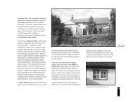
character in detail4.15 The West Arms Hotel is a prominent building in theconservation area <strong>and</strong> has many external <strong>and</strong> internal featuresof interest. It is listed Grade II as a fine hotel with somestrong 18th Century vernacular character <strong>and</strong> detail. It ismainly of 18th Century date but may originate from the 1617th centuries. It is a combination of two storey <strong>and</strong> singlestorey with attic elements; it has projecting bays to the centre<strong>and</strong> left of the front elevation. It is constructed of whitewashedrubble under a steeply pitched slate roof with largestone chimney stacks. Windows tend to be two or three lightcasements with small panes under segmental brick heads. It islikely to have originated as a farmhouse during the 17thcentury, later becoming a hotel. There are cobblesimmediately in front of the hotel <strong>and</strong> a gabled timber openporch. A row of four mature trees within the gardens providesa backdrop that contributes to its setting. Internally there is afine inglenook fireplace <strong>and</strong> some deeply chamfered beams.4.16 The barns <strong>and</strong> outbuildings to the West Arms are built ofstone <strong>and</strong> slate with black painted timber windows. Over theyears some flat roofed extensions have been constructed to therear of the hotel, to enlarge the hotel facilities <strong>and</strong> to link barnsto the main hotel. There could be scope to redevelop these inthe future to provide a less ad-hoc <strong>and</strong> more unifiedarrangement.15
character in detail4.17 Whitegate Cottage to the North of the West Arms has 4.18 The public realm has largely escaped the introductionits origins as a single storey long house. It was used for a of too much street clutter <strong>and</strong> modern highwaytime until about 2002 as ancillary accommodation to the improvements, <strong>and</strong> as a result offers a rural streetscape.West Arms Hotel but is now back in private residential use. Some pavements exist, but generally their presence isIt is constructed of white painted stone with a slate roof <strong>and</strong> minimal. The private curtilage to the front of the Westhas a simple frontage with multi-paned modern windows Arms is paved with cobbles from the river; this serves as a<strong>and</strong> large irregular stone lintels. It has a rear stone wall sample of vernacular paving which could be reproduced inwith cock <strong>and</strong> hen copings. The front concrete capped appropriate places in any enhancement scheme. Thestone wall follows the line of the road, emphasising the distinctive wooden guidepost surmounted by a lantern inlinear route from the bridge to the centre of the village. the centre adds to the village charm.16
summary of negative features5 Summary of Negative Features5.1 A number of factors have been identified as causingdetriment to the visual quality <strong>and</strong> character of the area. Theseinclude:Loss of Traditional features <strong>and</strong>Architectural Detail5.2 Unfortunately a number of small alterations over time havegradually altered the special character <strong>and</strong> appearance of thearea. There are few surviving examples of original ortraditionally detailed window or door styles. In some areastraditional stone boundary walls have been removed <strong>and</strong>replaced either in a modern alternative or have not been replacedat all. The rendering of the original building fabric in a modernhard render, the replacement of roofs incorporating ridge ventsor interlocking ridge tiles <strong>and</strong> the re-pointing of walls in hardcement mortar are all examples of minor works whichcumulatively erode <strong>and</strong> adulterate the special character <strong>and</strong>appearance of the area.Inappropriate Alterations5.3 Extensions must respect the size, scale <strong>and</strong> quality of theexisting building. Certain features such as porches, baywindows <strong>and</strong> flat roof extensions can in some instances appearincongruous with the style <strong>and</strong> period of the existing building.Parking <strong>Area</strong>s5.4 Parking does not currently appear to cause much visualintrusion within the <strong>Conservation</strong> <strong>Area</strong>. However, whereparking is provided to the rear of the West Arms Hotel <strong>and</strong> aninformal parking area is evident adjacent the bus stop, someinformal l<strong>and</strong>scaping or re-surfacing works could enhance theirappearance. However, it would be essential not to introduceincongruous urban features.Appearance of the Traffic Isl<strong>and</strong>5.5 The triangular traffic isl<strong>and</strong> in the centre of the village hasconcrete kerbs <strong>and</strong> macadam surface which appear a little harshwithin the surrounding rural environment. The guidepost at itscentre is a particular feature of interest <strong>and</strong> the isl<strong>and</strong>arrangement does nothing to enhance it.17
18summary of negative features
Part 2Management Plan19
6.1GENERALmanagement planPROPOSALS FOR PRESERVATION AND ENHANCEMENTImportant viewsTreesArchaeologyBoundary DetailsAlterations <strong>and</strong> New DevelopmentReinstatement of Lost FeaturesViews into, out of <strong>and</strong> within the <strong>Conservation</strong> <strong>Area</strong>, in particular those of the Church areessential to the special quality of place. Their protection <strong>and</strong> enhancement will be animportant consideration in the determination of any proposed development.Trees are a strong character feature within this <strong>Conservation</strong> <strong>Area</strong>, therefore the removalof significant trees within the area will be resisted. Where removal is unavoidable thenan appropriate replanting scheme must be undertaken. See section 8.1 of this document.Varying levels of archaeological mitigation may be required in response to developmentproposals within the historic core. Early consultation with the Clwyd-PowysArchaeological Trust in relation to any proposed new dwelling or extension isencouraged to prevent delay at the application submission stage.Stone boundary walls are specific character features of the <strong>Conservation</strong> <strong>Area</strong>, their totaldemolition will be resisted. The use of traditional methods of construction <strong>and</strong> materialsincluding the use of lime mortar (no cement) is encouraged in all schemes of repair <strong>and</strong>reinstatement of the traditional stone boundary walls.Proposals must be designed in accordance with Design Guidance as contained withinSection 7.0 of this document.Traditional architectural details <strong>and</strong> local materials are important to the architecturalinterest <strong>and</strong> value of the area <strong>and</strong> should be retained where possible. The repair orreinstatement of traditional features is strongly encouraged.Highway Improvements Highway work should be designed in accordance with guidelines as set out in Section 7.0of this document. Any proposed Highway works must have special regard to thedesirability of retaining the special rural character of the area by limiting the use ofunnecessary road signage, road markings <strong>and</strong> the preservation of grass verges, forexample. Any proposals for the replacement or renewal of the traffic isl<strong>and</strong> must seek toenhance the village centre in sympathy with its historic <strong>and</strong> rural setting.20
management plan6.2GENERAL PROPOSALS FOR PRESERVATION AND ENHANCEMENTThe following have been identified as opportunities for the enhancement of the <strong>Conservation</strong> <strong>Area</strong>. The undertaking of theseworks is dependent upon the availability of funding or grant assistance:ENHANCEMENT PROPOSALSCar Park <strong>and</strong> surface Improvements - Parking areas, inparticular to the side <strong>and</strong> rear of the West Arms Hotelcould benefit from some simple non-fussy l<strong>and</strong>scaping<strong>and</strong> re-surfacing in a soft <strong>and</strong> natural materialsympathetic to the rural surroundings.West Arms Hotel signage - The collection of piecemealsignage to the hotel façade detracts from the overallappearance of the building. Rationalisation of thesesigns in quality materials <strong>and</strong> style would make asignificant visual improvement.Traffic Isl<strong>and</strong> - The appearance of the traffic isl<strong>and</strong>could be greatly enhanced by the use of more appropriatesurface materials, planting <strong>and</strong> re-painting of theguidepost.RESPONSIBLE BODYPrivate L<strong>and</strong> owner/Transportation <strong>and</strong> AssetManagement Department, WCBCPrivate L<strong>and</strong> ownerTransportation <strong>and</strong> Asset Management Department,WCBC21
design guidance7 Design Guidance7.1 The character of the individual buildings <strong>and</strong> streetelevations, which together form the <strong>Conservation</strong> <strong>Area</strong>, derivesform a number of factors to which the following design guidancerelates. Within these parameters there is scope for high qualityarchitectural innovation, provided that this is sympathetic to theexisting character in terms of the following:Scale7.2 Restoration <strong>and</strong> re-development must respect traditionalplot widths <strong>and</strong> avoid massive repetitive <strong>and</strong> unrelieved facadeswhich typify so many modern designs.Proportion7.3 In most ofthe buildingswithin the<strong>Conservation</strong><strong>Area</strong>, therelationshipbetweenwindows, doors,floor heights <strong>and</strong>the relationshipof solid to voidin the design ofelevations is crucial. Traditional proportions should be emulatedin new development.Building Line7.4 Frontage development must conform to the historic streetpattern. The historic layout of the village is linear with thebuildings generally facing onto the road with their rooflinesparallel to it.Roofs7.5 The roof line is adominant feature of abuilding <strong>and</strong> retention of theoriginal height, shape, pitch,verge <strong>and</strong> eaves detail <strong>and</strong>ornamentation is essential.Flat roofs are alien to localtradition <strong>and</strong> generallyunacceptable. Chimneystacksare important featuresof the roof-scape <strong>and</strong> shouldbe retained even if no longerrequired. Where roofingmaterials are to be replacedthe new materials should match the colour, size <strong>and</strong> texture ofthose being replaced if those were traditional <strong>and</strong> historicallyappropriate. If ventilation is required, this should be achievedby inconspicuous means (e.g. Under eaves ventilation) butvisible roof vents would not be acceptable.External Walls7.6 Any alteration or repair to external walls must respect theexisting building materials <strong>and</strong> match them in texture, quality<strong>and</strong> colour. Every effort should be made to retain or re-usefacing brickwork or stonework. Re-pointing should be carriedout with a mortar to match the existing in colour, type <strong>and</strong>texture <strong>and</strong> historically would have consisted of lime <strong>and</strong> s<strong>and</strong><strong>and</strong> possibly other fine aggregates such as grit. Modern, hardcement renders are unacceptable as they prevent the evaporationof moisture, which can accumulate between the wall <strong>and</strong> therender causing damp internally <strong>and</strong> should be replaced with alime alternative.22
design guidanceRainwater Goods7.7 Rainwater goods should be repaired if original orreinstated in original materials. Plastic guttering is notappropriate to Listed Buildings <strong>and</strong> buildings in <strong>Conservation</strong><strong>Area</strong>s as it is not historically correct <strong>and</strong> it does not enhance abuilding's character.Windows7.8 Windows should be correctly proportioned, well relatedto each other <strong>and</strong> adjoining buildings <strong>and</strong> should respect theexisting openings. Retention of original windows must alwaysbe the first consideration but any repair or replacement shouldalways match the original. This includes not only structuralelements of the window but also historic glass <strong>and</strong> originalwindow furniture. Particularly important is the method ofopening, the set back within the reveal <strong>and</strong> the sections ofglazing bars. The thickness <strong>and</strong> moulding of glazing bars, thesize <strong>and</strong> arrangement of panes are vital elements indetermining appropriate replacement windows, which respectthe age of a building. Replacement of timber or iron windowsin a uPVC alternative, no matter what the pattern isundesirable. All windows should have a traditional paintedfinish rather than a modern stained alternative.Doors7.9 Original door-cases, doors <strong>and</strong> door furniture should beretained wherever possible. Replacements must match theoriginal in proportion, style <strong>and</strong> materials <strong>and</strong> should have apainted finish. Porches should be designed within the overallcontext <strong>and</strong> architectural style of the building <strong>and</strong> in referenceto any appropriate nearby styles. They should not dominatethe front elevation.Boundary Treatment7.10 The removal or alteration of boundary walls will not beviewed favourably. Repair should be carried out usingidentical materials <strong>and</strong> in the same style or bond <strong>and</strong> missingcopings replaced to match the existing. The use of a hardcement mortar to re-point joints is unacceptable as it increasesthe rate of deterioration of soft stone.Surfaces7.11 The overuse of insensitive macadam finishes should beavoided <strong>and</strong> the opportunity taken to lay traditional, naturalmaterials preferably local in origin, <strong>and</strong> whose colour, texture<strong>and</strong> pattern are in sympathy with the character of the area <strong>and</strong>sensitive to adjacent buildings.Highway Works7.12 Redundant or unnecessary street furniture such as signs,bins or poles should be removed to reduce the effects of streetclutter. Any historic features such as street signs must beretained <strong>and</strong> any new items such as bollards, street-lightingcolumns <strong>and</strong> sign-posts, etc must be carefully integrated withinthe streetscape <strong>and</strong> relate well to adjacent buildings <strong>and</strong> thearea as a whole. The number <strong>and</strong> size of road signs must bekept to a minimum <strong>and</strong> only illuminated where essential onsafety grounds. Backing plates should be grey or black <strong>and</strong>luminous yellow must be avoided. Where road lines areessential they must be of a restricted width within the<strong>Conservation</strong> <strong>Area</strong>.Micro Energy Generation7.13 Whilst the use of micro energy generation systems is tobe encouraged they are not acceptable where equipment isfixed to building frontages or main or visible elevations wherethey would have a negative visual impact upon the<strong>Conservation</strong> <strong>Area</strong> or where the fabric, character or setting of aListed Building are detrimentally affected.23
conservation area controls8 <strong>Conservation</strong> <strong>Area</strong> ControlsSpecial Controls8.1 In order to protect the special environment, stricter controlsexist within the <strong>Conservation</strong> <strong>Area</strong>. These are not intended as ahindrance to change, but as positive management to safeguardthe character of the area as a whole. These include:●●●Additional powers of control to dwelling houses forextensions, roof extensions <strong>and</strong> alterations, cladding,garages <strong>and</strong> satellite dish location.Most works involving total demolition require<strong>Conservation</strong> <strong>Area</strong> Consent. Consent for demolitionwill not normally be granted until it is known whatform redevelopment will take.Work to trees requires six weeks notice to be given tothe Council.With all proposals for development <strong>and</strong> the display ofadvertisements in a <strong>Conservation</strong> <strong>Area</strong>, greater care is necessaryto ensure that schemes enhance <strong>and</strong> preserve the area's specialcharacter. Design <strong>and</strong> choice of materials are of particularimportance in this respect.Listed Buildings8.2 A Listed Building is a building that is considered to be of'special architectural or historic interest' <strong>and</strong> as such requiresspecial protection. Once listed, a building is protected under thePlanning (Listed Buildings <strong>and</strong> <strong>Conservation</strong> <strong>Area</strong>s) Act 1990.The Listing protects the building both externally <strong>and</strong> internallyirrespective of the reason for listing as well as any object orstructure fixed to the building (whether or not mentioned in thelisting description). The listing also extends to any object orstructure within the 'curtilage' of the building, which has existedsince before 1st July 1948. This is to ensure that the specialcharacter of both the building <strong>and</strong> its setting are protected.248.3 Where works are proposed to a Listed Building, it isalways advisable to check with the Council's Planning Authoritywhether Listed Building Consent is required. In any worksproposed, special regard must be given to the desirability ofpreserving the building, its setting <strong>and</strong> special features ofinterest.8.4 In considering any works to a Listed Building the principleobjective must be to retain all original features <strong>and</strong> fabric of thebuilding wherever possible. Listed Building Consent is requiredfor the demolition of a listed building or for alteration, whichwould affect the building's character, integrity or special interest.This could include changing windows <strong>and</strong> doors, changingroofing materials, painting brickwork, moving or removinginternal walls or plasterwork, fireplaces, floorboards orstaircases. Like for like repairs may not need consent but it isalways advisable to check prior to undertaking any works as thecarrying out of works without the necessary consent is a criminaloffence with significant penalties for those involved following asuccessful prosecution.Scheduled Ancient Monuments8.5 Within the <strong>Conservation</strong> <strong>Area</strong>, the mound within theChurchyard, Tomen Garmon, is a Scheduled Ancient Monument.Scheduled Ancient Monuments are nationally important sites <strong>and</strong>monuments, which have legal protection. In some cases ListedBuildings can also be Scheduled Ancient Monuments. If youpropose to carry out any work, alteration or excavation,Scheduled Ancient Monument Consent must be obtained.Applications for consent should be made to the Welsh AssemblyGovernment.
conservation area controlsCommercial Buildings8.5 Properties in commercial use do not have PermittedDevelopment Rights under the Town <strong>and</strong> Country Planning(General Permitted Development) Order 1995. Anyexternal works to unlisted commercial buildings other thanrepair <strong>and</strong> maintenance are likely to require PlanningPermission.25
conservation area controls9 Sources of FundingA fundamental principle of all grant schemes is that grant cannotbe offered after the work has been started. All grants arediscretionary <strong>and</strong> rates may vary. Early consultation withpossible providers is essential.Cadw: Welsh Historic MonumentsCadw is the principal public agency offering grant aid forhistoric buildings in Wales. The key grant schemes summariseas:Historic Buildings Grant●For the repair <strong>and</strong> restoration of historic fabric of building's of'outst<strong>and</strong>ing' architectural or historic interest. Grants arenormally paid in instalments or on completion of the work. Thepercentage of the total eligible cost of repair payable throughgrant aid is dependent on the building type, for example:Religious 50%Trusts <strong>and</strong> Charities 40%Domestic/Private 30%Commercial/Industrial 30%Public 30%Conditions of the grant may require a specialist to undertake <strong>and</strong>oversee the works <strong>and</strong> allow a degree of public access to theproperty once works are completed. The owner must also ensurethat the property is kept in good condition <strong>and</strong> take out <strong>and</strong>maintain adequate insurance cover for the property.<strong>Conservation</strong> <strong>Area</strong>s Grant●For works to the external structure or appearance of historicbuildings, which significantly enhance a <strong>Conservation</strong> <strong>Area</strong>.Grants are again paid by instalments or on completion of thework based on the following rates:Religious 40%Trusts <strong>and</strong> Charities 30%Domestic/Private 25%Commercial/Industrial 25%Public 25%Similar to the Historic Building Grant, conditions may require aspecialist to undertake <strong>and</strong> oversee the works. The owner mustalso ensure that the property is kept in good condition <strong>and</strong> takeout <strong>and</strong> maintain adequate insurance cover for the property.26
Appendix 1Listed BuildingsListed BuildingThe West Arms HotelTelephone Call Box adjacent to W gable end of H<strong>and</strong> InnChurch of St GarmonOld Mill Welsh ShopGradeIIIIIIIIScheduled Ancient MonumentsTomen Garmon (Mound located within the Churchyard of the Church of St Garmon)27
Appendix 2<strong>Conservation</strong> Policy GuidanceMain Legislation National Policy Guidance Local PolicyTown <strong>and</strong> CountryPlanning Act 1990Planning (Listed Buildings<strong>and</strong> <strong>Conservation</strong> <strong>Area</strong>s)Act 1990Planning Policy WalesWelsh Office Circular 61/96:Planning <strong>and</strong> the Historic Environment:Historic Buildings <strong>and</strong> <strong>Conservation</strong> <strong>Area</strong>sWrexham Unitary DevelopmentPlan (LDP in preparation 2009)Local Planning Guidance Note 4:<strong>Conservation</strong> <strong>Area</strong>sAncient Monuments <strong>and</strong>Archaeological <strong>Area</strong>s Act 1979Welsh Office Circular 1/98: Planning<strong>and</strong> the Historic Environment: Directionsby the Secretary of State for WalesLocal Planning Guidance Note 30:Design: A Guide for Developers<strong>and</strong> Architects when designingResidential DevelopmentsTechnical Advice Note 12: DesignWelsh Office Circular 60/96:Planning <strong>and</strong> the Historic Environment:Archaeology28
Appendix 3Glossary of Architectural TermsAbutmentCasementCatslideChamferChancelCock <strong>and</strong> HenCopingDormerEavesGableInglenookJambLintelLong HouseNaveObeliskParapetSolid part of a pier from which an arch springs, or the extremities of a bridgeA window where the opening lights are hung on hingesAn extension of a sloping roof at the same pitch over a projection to a buildingSurface formed by cutting off the squared edge, normally at a 45-degree anglePart of the east end of a church set apart for the clergyToothed capping to a wallThe top course of a wall parapet or chimneyA window projecting from a roofThe lower, overhanging section of a pitched roof<strong>Area</strong> of wall, often triangular at the end of a pitched roofLarge recess for a hearthThe vertical side of an openingHorizontal beam used as a finishing piece over a door or windowCombined house <strong>and</strong> byre, with internal access betweenThe main body of a churchA tapering pillar of square plan <strong>and</strong> ending pyramidallyFeature used to conceal a roofPerpendicular Historical division of English Gothic architecture covering the period 1335-1530.The name is derived from the upright tracery panels used at the timePiersAn isolated mass of constructionPlinthProjecting courses at the foot of a wall or columnQuoinDressed masonry bonded to the corners of buildingsRenderThe plastering of a surface with plaster, stucco or another finishRoughcastPlaster mixed with a course aggregateSash WindowsA window which moves on vertical grooves, either with one frame fixed (singlehung) or both moving (double hung)StringcourseHorizontal stone course or moulding projecting from the surface of the wallTraceryDelicately carved stonework usually seen in the Gothic style of windowTransomA horizontal bar dividing a windowVernacularA term to describe local regional building forms <strong>and</strong> types using localmaterials without gr<strong>and</strong> architectural pretensionsReferencesThe Buildings of Wales:Clwyd, Edward Hubbard, 1986Guidance on <strong>Conservation</strong> <strong>Area</strong> Appraisals, English Heritage, 2005Guidance on the Management of <strong>Conservation</strong> <strong>Area</strong>s, English Heritage, 2005100 Years in the Valley, Y Glyn a fu, Dewi Parry Jones <strong>and</strong> Robert Owen Jones, 1998Useful ContactsThe Institute of Historic Building <strong>Conservation</strong> - www.ihbc.org.ukCadw: Welsh Historic Monuments - www.cadw.wales.gov.ukThe Royal Institute of British Architects - www.riba.orgThe Society for the Protection of Ancient Buildings - www.spab.org.ukThe Royal Institution of Chartered Surveyors - www.rics.org.ukThe Georgian Group - www.georgiangroup.org.ukThe Victorian Society - www.victorian-society.org.ukClwyd Powys Archaeological Trust - www.cpat.org.ukThe Royal Town Planning Institute - www.rtpi.ork.uk29