Earth Heritage Issue 26 - Wrexham County Borough Council
Earth Heritage Issue 26 - Wrexham County Borough Council
Earth Heritage Issue 26 - Wrexham County Borough Council

Create successful ePaper yourself
Turn your PDF publications into a flip-book with our unique Google optimized e-Paper software.
Face LiftEight years ofachievementunder grantsscheme<strong>26</strong>Summer 2006<strong>Issue</strong>GeoparksHow Fforest Fawrbecame aWelsh first
Landmark publicationsWelcome to the Summer 2006 edition of <strong>Earth</strong> <strong>Heritage</strong> – 32 pages packed witha veritable geo-diversity of news and features.Usually we review new publications at the end of the magazine, but this issuesees some significant newcomers that deserve deeper scrutiny. Among these isGeological conservation: a guide to good practice, published by EnglishNature. This important document updates and re-focusses the geoconservationeffort in England to reflect a raft of recent political, legislative and practicaldevelopments. The revised guidance is published in advance of English Naturebecoming part of a new agency – Natural England – in the autumn and signalsits successor’s continuing commitment to geoconservation. We also take a lookat the highly successful A Landscape Fashioned by Geology series, producedjointly by Scottish Natural <strong>Heritage</strong> and the British Geological Survey. Its 14published titles (six more to come) have sold over 100,000 copies and set anadmirable benchmark for anyone seeking to explain the geological foundationsof landscape in an understandable, informative way. Not to be outdone, Waleshas broken new ground by producing a user-friendly soils booklet that explainsthe principles of soil science in straightforward terms, provides numerouspossibilities for field visits and places soils in their landscape context – not aneasy task!Finally, congratulations to Fforest Fawr for becoming Wales’ first Geopark andto the NEWRIGS Group for completing its two-year-long site survey, and forestablishing a network of 127 RIGS! Reports on these and a great many moretopics lie in the pages ahead. I do hope you enjoy the issue.On other pagesOutcrops – pages 3-6Close to the edge – p 7Face Lift - Looking great at eight – p 8Fforest Fawr: A Welsh first – p 10A ton of new RIGS! – p 12Race to savefossil forest– p 14A quarry for the community – p 15Celebrating a landscape fashioned bygeology – p 16Soils: raising the profile of adowntrodden asset – p 18Breaking new ground – p 20Managing Editor<strong>Earth</strong><strong>Earth</strong> <strong>Heritage</strong> is a twice-yearly magazine produced by theJoint Nature Conservation Committee, English Nature,Scottish Natural <strong>Heritage</strong> and theheritage Countryside <strong>Council</strong> for Wales. Thevoluntary geoconservation sector is amajor contributor. We would like to thank all those who have assisted with thepreparation of the magazine. However, the opinions expressed by the contributors arenot necessarily those of the above organisations. A database listing all the articlescarried up to issue 17 is available on CD. Contact any member of the editorial board.Key articles from this and previous issues of <strong>Earth</strong> <strong>Heritage</strong> can be found on the Web at:www.seaburysalmon.com/earth.htmlOffers of articles should be directed to the relevant members of theeditorial board, who are:Managing EditorSTEWART CAMPBELL, Countryside<strong>Council</strong> for Wales, Maes-y-Ffynnon,Ffordd Penrhos, Bangor, Gwynedd LL572DN. Telephone 01248 385693, e-mail:s.campbell@ccw.gov.ukEditorsDAVID EVANS, English Nature,Northminster House, Peterborough PE11UA. Telephone 01733 455204, e-mail:david.evans@english-nature.org.ukCOLIN MACFADYEN,Scottish Natural <strong>Heritage</strong>, 2 AndersonPlace, Edinburgh EH6 5NP.Telephone 0131 446 2055,e-mail: colin.macfadyen@snh.gov.ukNEIL ELLIS,Joint Nature Conservation Committee,Monkstone House,City Road, Peterborough PE1 1JY.Telephone 01733 56<strong>26</strong><strong>26</strong>,e-mail: neil.ellis@jncc.gov.uk2MICK STANLEY, GeodiversityConsulting, Park House, 8 KingStreet, Ripon, North YorkshireHG4 1PJ. Telephone 01765 609479,e-mail: mick.stanley1@btopenworld.comCYNTHIA BUREK,UKRIGS Geoconservation Association,Centre for Science Communication,University of Chester,Parkgate Road, ChesterCH1 4BJ. Telephone 01244 375444,e-mail: cburek@chester.ac.ukProductionSeabury Salmon, Seabury Salmon &Associates, The Old Pound, Ludford,Ludlow, Shropshire SY8 1PP. Telephone01584 877442. Fax 01584 875416.e-mail: eheritage@seaburysalmon.comCirculation<strong>Earth</strong> <strong>Heritage</strong> is free. Contact yourlocal Editor to be placed on themailing list.Soft-sediment challenge – p 21The joysof caving– p 22Beyond Aust – p 24More sparkle in northern jewel – p 25Hutton Trail opens – p 28Training helps travel trade boostgeotourism – p 29Unsung heroines – p 30Latest publications – p 31Cover photoThe majesty of the Brecon Beacons – part of the FforestFawr Geopark – comes through in this view of Pen-y-Fanand Corn Du from Mynydd Illtydd.Photo courtesy Fforest Fawr Geopark
Guide to good geological conservationThere is often an understandable lack ofknowledge amongst decision makers,landowners, local planning authorities andthose involved in wildlife conservationabout the importance of geologicalconservation, the threats to geological sitesand approaches that can be taken inconserving, managing and promoting ourgeological heritage. In an attempt toimprove the situation in England, and toupdate guidance produced in 1990 (<strong>Earth</strong>Science Conservation in Great Britain –A Strategy: Nature Conservancy<strong>Council</strong>), English Nature has publishedGeological conservation: a guide togood practice.The 145-page colour document drawson the practical experience of EnglishNature’s partners in the voluntarygeological conservation sector,geological societies and local authorities aswell as our own experience managing ournetwork of nationally important geologicalSites of Special Scientific Interest.The guide to good practice is based on arevised site-type classification anddescribes the importance of our geologicalheritage and the need for its conservation.It provides management solutions to a widerange of threats and opportunities andillustrates good practice through 35 casestudies. It also includes guidance onsite condition monitoring,the preparation of site management plansand the production of Local GeodiversityAction Plans.The guide to good practice reflects themany political, policy and legislativechanges that have affected geologicalconservation in the UK since the NCCguide was published. These include:● the rise of the voluntary geologicalconservation sector;● new conservation legislation;● government targets for the managementof protected geological sites;● the inscription of the Dorset and EastDevon World <strong>Heritage</strong> Site;● the declaration of a number of EuropeanGeoparks;● the provision of resources for geologicalconservation through the AggregatesLevy Sustainability Fund;● the initiation and growth of LocalGeodiversity Action Plans; and● the recent government policy describedin Planning Policy Statement 9:Biodiversity and GeologicalConservation.Geological conservation: a guide to goodpractice, aims to capture and share goodpractice within the context of all thesechanges and is available free by visitingEnglish Nature’s website (see below) orcontacting Colin Prosser oncolin.prosser@english-nature.org.uk.It can be downloaded from www.englishnature.org.uk/pubs/publication/PDF/GeologyHandbookPart1.pdf andwww.english-nature.org.uk/pubs/publication/PDF/GeologyHandbookPart2.pdfColin ProsserHead of Geology, English NatureWelsh RIGS groups unite on leafletThe Association of Welsh RIGS Groups, currentlycomprising North East Wales RIGS Group(NEWRIGS), Gwynedd and Môn RIGS Group andCentral Wales RIGS Group, has produced a newgeneral leaflet about Regionally ImportantGeodiversity Sites (RIGS) and RIGS groups inWales.Aimed at landowners and the public, the leafletdescribes what ‘geodiversity’ and‘geoconservation’ are, what RIGS are and howthey are chosen, and what RIGS groups do andhow to get involved in their activities.The leaflet was based on the original RIGS generalleaflet, updated and made more relevant for RIGSin Wales. It follows the usual third-A4 format, isbilingual and illustrated with examples ofGeodiversity sites from the three regions coveredby the Welsh groups. All three groups havereceived Aggregates Levy Sustainability Fund(ALSF) grants, administered by the WelshAssembly Government, to establishcomprehensive networks of RIGS in their areas.The leaflet stems from the need to informlandowners and tenants of RIGS on their land,and to explain the role of RIGS groups ingeoconservation. Although NEWRIGS has nowfinished its project (see pages 12-14), theother two groups still need to contactlandowners and tenants about the geologicalfeatures on their land. The leaflets shouldmake this easier and more professional.Although the leaflet started as a NEWRIGSproject, some joined-up thinking by thegroups at their regular liaison meetingsresulted in the all-Wales leaflet. Funding forthe design of the leaflet was kindlyprovided by NEWRIGS via an ‘Awards forAll’ grant.Stewart Campbell, CCW3
Seeking your views on fossil codeFossils are an irreplaceable and finiteresource used for scientific investigation,education, recreation and commercialpurposes. However, this element ofScotland’s geological heritage is vulnerableto abuse and damage, as illustrated in thecase of Birk Knowes SSSI, andconsequently requires safeguarding andconsidered management to ensure itssurvival for future generations. To helpachieve this, Scottish Natural <strong>Heritage</strong>(SNH) has been given the task of preparingthe Scottish Fossil Code.SNH considers that continued fossilcollecting in Scotland is vital for theadvancement of palaeontology and thedevelopment of geological sciencegenerally. However, collecting should beundertaken responsibly, with due care givento the fossil resource, collected fossils andfossil collections. The Scottish Fossil Codewill therefore provide guidance on bestpractice in the collection, identification,conservation and storage of fossilspecimens found in Scotland. The Code isintended to encourage fossil collectors –institutional, academic, amateur andcommercial – to collect responsibly and tomanage collections so that they will beuseful to future generations.The Code will comprise:● an introduction to fossils, the fossilheritage of Scotland and the legalities ofcollecting;● general guidance for collectors onresponsible collecting;● further guidance for specialist groupsand others with a particular involvementwith Scotland’s fossil heritage;● advice on donating fossil specimens tomuseums and general information on therole of museum and other public bodiesin the care and maintenance of fossilcollections in Scotland;● sources of further information includingthe identification, collection and care offossils.SNH would welcome your views on a draftversion of the Scottish Fossil Code whichwill be available in the autumn of 2006 atwww.snh.org.ukColin MacFadyen, SNHNational geology festgoes annualDot com siteupgradedBegun as a listing of events for theScottish Geology Festival 2001, thewww.scottishgeology.com websitehas grown substantially to become animportant gateway to Scottish geologyon the web.Launched officially at the start ofScottish Geology Festival 2003, thesite carries a range of informationpertinent to Scottish geology including:the development of Scotland throughgeological time; ‘classic’ geologicalsites; famous Scottish geologists;RIGS in Scotland; useful web links;and information on collecting inScotland (soon to include the ScottishFossil Code – see above). During2005, there were over 3,000 ‘hits’(visits) per month to the site.4From 2006, the ‘Rock On’ ScottishGeology Festival will be run on anannual basis. Its organising partnershiphas taken the decision because of thewillingness among individualenthusiasts, geologists in industry andvarious groups, societies and museums,to organise and run events to meet thepublic’s growing appetite for geology.Throughout September 2006, there willbe the usual popular mix of fun,informal and formal geological eventsfor all ages, held across the length andbreadth of Scotland.The organising partnership behind thefestival comprises the HunterianMuseum in Glasgow, the NationalMuseums of Scotland, Scottish NaturalAt the start of 2006 the organisingpartnership behind the websitedecided to overhaul and refresh it.Users will find it easier to navigate andbrowse the site which has beenupdated with fresh information to beaugmented shortly by a new sectionon Scotland’s geoparks. It is hopedthat by early 2007, the site will containpages on geotourism in Scotland,<strong>Heritage</strong>, theBritishGeologicalSurvey, theScottish <strong>Earth</strong>ScienceEducationForum, OurDynamic<strong>Earth</strong> and thegeologicalsocieties ofGlasgow andEdinburgh. The partnership is led thisyear by the Hunterian Museum.If you wish either to host or run anevent, you can do so by filling out theregistration form onwww.scottishgeology.comwhich will list all the locations thatoffer something for the geotourist interms of interpretation, available eitheron-site or through leaflets and/orguidebooks.Check out the revitalisedwww.scottishgeology.com forevents for Scottish Geology Festival2006.
SESEF plansto continuedevelopmentThe Scottish <strong>Earth</strong> Science EducationForum (SESEF), the network whichpromotes and supports the teaching of<strong>Earth</strong> Science in Scotland’s schools, iscontinuing to develop its activities andexperience some changing faces.SESEF appointed Clare Britton as the newdevelopment officer in January 2006 tomaintain its successful projects and plannew initiatives.SESEF plans to make its ‘Continuingprofessional development’ workshops forteachers of the Scottish 5-14 curriculumInitial teacher training (ITE) Students at the University of Edinburgh, taking a close look at the resources thatSESEF offers with its Scotland's Journey workshop. Photo by Alan Dohertymore widely available. The workshops,provided in collaboration with the <strong>Earth</strong> The SESEF Steering Committee also has a Sylvia Jackson (Member of the ScottishScience Education Unit, saw their 1,000 th new chairman, Neil Clark of the Hunterian Parliament).participant in 2005.Museum in Glasgow, who hopes to involvemore teachers in its meetings, and thus All current and future projects andThe organisation has developed a new 5-14 ensure that SESEF support is constantly initiatives could be aligned with the ethosworkshop resource on landscape and tailored to meet their needs. and outcomes of A Curriculum forweather, in collaboration with the RoyalExcellence, the Scottish Executive’s currentMeteorological Society and Edinburgh An <strong>Earth</strong> Sciences Trust has been comprehensive review of the ScottishDistrict <strong>Council</strong>. This is now being piloted. established to facilitate initiatives and curriculum. SESEF is working to ensureA new project, funded by the Petroleum resources that support and promote geology that the curriculum review incorporatesExploration Society of Great Britain, is in the secondary curriculum. Its Chairman more on the teaching of <strong>Earth</strong> science andunder way to provide direct in-school is Stuart Monro (scientific director for of science in general.support for current and aspiring teachers of Dynamic <strong>Earth</strong>). Other members include Clare Brittonthe Higher Geology course. professional geologist Alan Parsley and Development Officer SESEF<strong>Earth</strong> Science teachers fix conference datesThe 2006 <strong>Earth</strong> Science Teachers’ Association Course andConference will be held at the University of Bristol from 15-17September. The meeting will include workshops for primary andsecondary teachers, keynote lectures by leading <strong>Earth</strong> scientistsand field excursions. Residential accommodation will be atClifton Hill House, a short walk from the <strong>Earth</strong> ScienceDepartment in the Wills Memorial Building of the University.The first day comprises in-service training and workshops forlocal teachers and ESTA members. INSET for teachers of pupilsat Key Stages 1 to 4 is aimed at improving the teaching of the<strong>Earth</strong> Science component of the National Science Curriculum.Professor Mike Benton will deliver a keynote lecture on ‘MassExtinctions’.Day two includes lectures on climate change, the Mendips andvolcanic geohazards, an open forum on ‘Facilitating Fieldwork’,and break-out sessions specifically tailored for primary andsecondary teachers.Day three will offer a variety of trips. These include: Sedimentsand structures along the Portishead coast; Unrivalledgeodiversity and biodiversity in Vallis Vale; In the Footsteps ofWilliam Smith - classic localities south of Bath; BurringtonCombe - some of the best karst scenery in Britain; A walkingtour around central Bristol looking at building stones.Attendance is open to all with an interest in <strong>Earth</strong> scienceeducation, either as a day visitor or on a residential basis. Thekeynote lecture is free, but there are modest fees for otheraspects of the conference. Details and booking forms areobtainable from the Conference Organiser, Dr Martin Whiteley,16 Amberley Gardens, Bedford MK40 3BT or the ESTA websitewww.esta-uk.org5
All-action on Anglesey plansThere has been a frenzy of activity ondeveloping a Local Geodiversity ActionPlan (LGAP) for Anglesey and onformulating a bid to secure EuropeanGeopark Network (EGN) status for theisland.As a result, the draft LGAP will bedistributed for consultation this autumnand the Anglesey GeodiversityPartnership (AGP) has also justsubmitted its geopark application forconsideration by the EGN.The Anglesey LGAP draws on theCheshire region LGAP process, butuses six interrelated themes, withbackground and explanatory text, tomake the plan accessible to potentialpartners who may have littleknowledge of geoconservation. TheLGAP forms a major strand inAnglesey’s geopark bid.On that front, the Partnership hopesthat the EGN will consider itsapplication during the BelfastGeoparks Conference in September(see page 10). The Partnership hasalready secured funds from theCountryside <strong>Council</strong> for Wales, theWelsh Assembly Government (from itsAggregates Levy Sustainability Fund)and Leader+ for a geoparks officer towork on the project, known asGeoMôn, for three years.Gwynedd & Môn RIGS Group, one ofthe chief drivers of the Anglesey LGAPand GeoMôn projects, has, in themeantime, completed three relatedprojects.First, it has published a soils booklet(see page 20). Second, it hascollaborated with Isle of Anglesey<strong>County</strong> <strong>Council</strong> to design and installinterpretation boards in South StackLighthouse and Breakwater CountryPark – two of Anglesey’s most visitedPrecambrian sites. Third, it hasestablished a new logo to spearheadthe GeoMôn project and to ‘brand’potential geopark products and events.The logo was drawn and donated bySir Kyffin Williams RA, GeoMôn Patronand leading artist. The logo (above left)depicts two standing stones, PenrhosFeilw, near Holyhead Mountain, anddepicts with great simplicity theessence of Anglesey’s geology,landscape and cultural inheritance.- Stewart Campbell, CCWWaiting for the lion to roar into public ownershipThe Lion of Scotland lies beneath Salisbury Crags,its Corrennie pelt ruffledwith symbolism.Has time tamed it to a domestic tabbywhose petulant yams – the politicians’ “I am”s – make a mockery of a hundred men?Twenty tons of granite sitsunblinking,letting you make up your own mind.© Rowena M. LoveRowena Love’s poem reflects the publicopinion that cries for the ScottishParliament, in its unfinished-lookingbuilding just across the road fromHolyrood Park, to buy the ‘Lion ofScotland’ for the nation. The Correnniegranite sculpture has been titled the ‘Lionof Scotland’ by the public and feeling ishigh for the country to own it. More than100 people from all walks of life gatheredto hear a passionate tribute to the genius6Ronald Rae with his ‘Lion of Scotland’.Photo by Mick Stanleyand dedication of Ronald Rae to hishand-carved art from Bishop NevilleChamberlain and Richard Holloway,Chairman of the Scottish Arts <strong>Council</strong>.The Makar Press poets also recited theirpoetry in celebration of the opening ofRonald Rae’s sculpture exhibition inHolyrood Park in May.Rowena Love’s ‘A Lion, lying’ was one ofsix poems in tribute to the granitesculptures. There are 12 stretching alongQueen’s Drive and The Duke’s Walk anda further nine around Holyrood Palace.Sponsorship for the year-long show isfrom the Scottish Executive New ArtsSponsorship Awards in conjunction withArts & Business Scotland, HughesAssociates, Aggregate Industries withgranite from Bardon Aggregates quarriesand supported by The List and MakarPress.- Mick Stanley, Geodiversity ConsultingDino Jaws, a new family exhibition atthe Natural History Museum, London,this summer introduces the fascinating,and sometimes disgusting, subject ofdinosaurs and their food.More information atwww.nhm.ac.uk/dino-jaws
Closeto the edgeAt Fairlight plans for a revetment, similar to an earlier one in the middle ground of this picture, are currently the subject of an objection because of the likely impact on thegeology.Coastal geological SSSI oftenproduce challenging caseworkbecause they sit on cliffs thatare unstable or being rapidlyeroded. This is particularly the casewhere property and developments areaffected.Hastings Cliff to Pett Beach SSSI in EastSussex contains extensive exposures ofsandstones and clays belonging to the lowerpart of the Lower Cretaceous HastingsGroup. These sediments have yielded fossilfish, reptiles (crocodiles, turtles, dinosaursand pterosaurs), early mammals and avariety of invertebrates as well as tracefossils.In addition, the site has yielded anextensive fossil-plant assemblage.Sedimentary structures can be seen on allscales. The site has provided many insightsinto the terrestrial environments of theWeald Basin during the early Cretaceousand will remain of great importance forfuture studies. Two reverse faults (theHaddocks and Fairlight Cove faults)provide examples of how the WealdAnticline developed. There are manylandslips along this coast. Recent activityin the landslip that fronts part of the villageof Fairlight has resulted in properties beinglost. The residents fear that further losses ofproperty are inevitable unless some actionis taken to stabilise the slip. A planningapplication for a scheme to grade and drainthe landslip and to support and protect itstoe with a revetment on the foreshore hasbeen submitted. English Nature isconcerned about the potential impacts ofthe scheme on the geology and hasDavid Evans,English NatureEaston Bavents – loosesediments in the NorwichCrag Formation are rapidlyeroded along this coast.At Lyme Regis (below), plans to stabilise a section ofthe sea front further could affect the Blue LiasFormation in the SSSI foreshore.All photos by David Evanseffect upon the West Dorset Coast SSSI.But Phase 4 proposes works within theSSSI that will affect the foreshore and cliffin front of Church Cliff and East Cliff tothe east of Lyme Regis. Potentially, anyscheme here could result in a decrease inthe available exposure of the Blue Lias andCharmouth Mudstone formations, as wellas having an impact on the fossil fish andreptile features of the site. English Naturehas been working with West Dorset District<strong>Council</strong> since the initial stages of theproject and has been advising on theimpacts that different options might haveon the SSSI.The sands, clays and gravels that form theNorwich Crag between Easton Bavents andCovehithe on the Suffolk coast form thetype site of the Baventian Stage of theBritish Early Pleistocene. This coastlinerecedes so rapidly that the landwardboundary of Pakefield to Easton BaventsSSSI was below high-tide, and the cliffs, aswell as part of the foreshore, were nolonger within the original SSSI boundary.The southern end of the site has been thesubject of a controversial, privately funded,coastal defence scheme that has largelyobscured the geological interest of EastonBavents Cliff. To address this and otherdiscussion with Rother District <strong>Council</strong>over the issue.issues, the site has been re-notified with alandward boundary at the estimatedposition of the coastline 50 years hence.Active landslides and coastal erosion arealso concerns at Lyme Regis. In recentyears several phases of engineering havehelped stabilise sections of the sea-front.This highlights how vulnerable to erosionthis stretch of coast is. English Natureconsidered objections to the notification atits <strong>Council</strong> meeting in June. Approval toobjected to the application. It is in Until now, these works have had no direct confirm the notification was given ■7
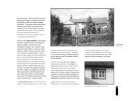
8FACE LIFTLookinggreat at8Bay,English Nature's Face LiftProgramme for enhancinggeological Sites of SpecialScientific Interest (SSSI) isnow in its eighth year. Since Face Liftwas initiated in 1999, more than 250projects have been undertaken with atotal spend of almost £600,000. Mosthave involved clearing vegetation or screeto re-expose geological faces which havebecome concealed over time due toneglect and lack of management.Since we last reported on Face Lift in<strong>Earth</strong> <strong>Heritage</strong> in 2004, several importantsites have been enhanced and goodexposures re-created.MichaelMurphy,English NatureCleared section of Quaternary loess at PegwellKent.Photo by Mick Murphy/English NatureSoutherham Grey Pit, Lewes, is designated as an SSSI for Cretaceousstratigraphy and vertebrate palaeontology. The site is of considerablestratigraphic importance, providing the only inland section in England ornorthern France of Chalk Marl and the lower half of the Grey Chalk. Inaddition, Lewes is renowned for its large diversity of fossil fish and thesite is the main resource of fossil fish in the area.Much of the section at Southerham Grey Pit had become concealed byscree as the face gradually collapsed in the years since the quarry waslast used. Because of a major road running behind the face, anengineering assessment was necessary to ascertain how removing thescree would affect face stability. Scree was then cleared from a 100metre section in February 2006, providing an excellent exposure.Pitt's Cleave is a large disused quarry near Tavistock,Devon, which exposes a thick dolerite sill of LowerCarboniferous age. Vegetation had concealed most of theexposures prior to a clearance project in 2005. Because thefaces were otherwise inaccessible, climbers werecontracted to clear growth, revealing good representativeexposures of sections through the sill.Cleared section of Southerham Grey Pit, Lewes, East Sussex.Photo by Mick Murphy/English Nature
9The cliffs at Pegwell Bay, Kent, aredesignated for several features ofgeological interest, including Cretaceous,Palaeogene and Quaternary stratigraphyand for Palaeogene vertebratepalaeontology. The site also exposes animportant unconformity between theCretaceous chalk and the Palaeogenesediments. The cliffs had become veryovergrown following the construction andsubsequent abandonment of a hoverport,concealing most of the features. A numberof sections, representing the entirestratigraphy of the site, were selected forclearance, which was undertaken over threeyears.Other sites which have been enhanced under the FaceLift Programme in the last two years include StonyFurlong Railway Cutting, Gloucestershire, and MilfordQuarry, Staffordshire.Climbers clearing scrub from a faceat Milford Quarry, Cannock Chase,Staffordshire.Photo by Angus TillotsonThis section at Pitt’sCleave Quarry,Devon, showingcolumnar-jointeddolerite, was clearedin 2005.Photo byMick Murphy/English NaturePurfleet Chalk Pits is aQuaternary site in Essex that isimportant both for research andeducation. It is close toLondon, in an area where thereare few sites suitable forstudent field trips. Vegetationclearance was undertaken in2005 to improve exposure offaces.Students examining a recently clearedsection at Purfleet Chalk Pits, Essex.Photo by Natalie Bennett/English NatureThis section through Mid-Jurassiclimestone at Stony Furlong RailwayCutting, Gloucestershire, had beenconcealed by vegetation and screefor many years before clearanceworks in 2006.Photo by Mick Murphy/English NatureAlthough we have made significantprogress in the enhancement ofgeological sites, much work remains.Increasingly, Face Lift is tackling morecomplex and large-scale enhancementworks, such as Southerham Grey Pit. Itis also important to establish agreedmanagement on many of the enhancedsites to ensure they remain in goodcondition in years to come. ■For more information about the FaceLift Programme, please contactmichael.murphy@english-nature.org.ukor tel: 01733 455216
Fforest Fawr:A Welsh firstThe Fforest Fawr (Great Forest)Geopark became the firstWelsh Geopark and the 24 thmember of the European andGlobal Geopark Network at the annualmeeting of the European GeoparkNetwork (EGN) on the Greek island ofLesvos in October 2005.The status was achieved as a result of theconcerted efforts of the Brecon BeaconsNational Park Authority, Cardiff Universityand the British Geological Survey.Representatives from these organisationsput together the successful application andreceived contributions to the submissionfrom the communities within the Geoparkarea.The Fforest Fawr Geopark was launched atthe Mountain Centre in Libanus on 21April 2006 by Lord Kinnock of Bedwellty,the Honorary President of the Geopark. Theevent not only celebrated the first EuropeanGeopark in Wales, but it was also the firstNational Park in the UK to be awarded thedesignation. Special guests included RtHon Rhodri Morgan (First Minister) and DrPatrick McKeever (Vice–Co-ordinator ofthe European Geopark Network), Dr TonyRamsay (Honorary Fellow of CardiffUniversity and Director of Fforest FawrGeopark), local schools, communities andthe Aberhonddu Male Choir. The awardwinningCambridge University ‘TimeTruck’ made a special appearance,providing hands-on experiences of fossilrubbing, gold panning, rock sculpture,earthquakes, volcanic eruptions, continentaldrift and rising sea-level consequences.Geologists, archaeologists and academicexperts were on hand to identify rock,fossil and mineral specimens.The Fforest Fawr Geopark covers an area ofsome 763 km 2 and contains some of themost outstanding mountain scenery insouthern Britain. The rocks and landscaperecord over 480 million years of geologicalhistory.In the west of the Geopark are theOrdovician and Silurian rocks of the WelshBasin, including the internationally knownLlandeilo and Llandovery type sections.10Eastwards, the looming mass of the BlackMountain (Y Mynydd Du) forms a ridgethat divides these ancient rocks from theDevonian Old Red Sandstone whichunderlies much of the Geopark and formsthe spectacular Fforest Fawr/BreconBeacons escarpment. In the southern areaof the Geopark are exposed CarboniferousLimestone, Millstone Grit and CoalMeasures which fuelled the IndustrialRevolution in Wales. The limestone hostssome of the largest cave systems andunderground passages known in Europe.The geomorphology is varied. Eight peakswithin the Brecon Beacons and FforestFawr escarpment rise to over 610m (2,000feet), including Pen-y-Fan (891m), FanFawr (734m), and Fan Hir (712m) and thelowest point is just 122m above sea level.Across the area, the evidence of the last(Devensian) ice age is clearly visible, fromthe morainic deposits within the Usk Valleyand the beautiful glacial lakes at Llyn y FanFach and Llyn y Fan Fawr.The geopark spans the transition from ruralmid-Wales to the industrial valleys of SouthWales. It illustrates the relationshipbetween geology, landscape, altitude, floraand 8,000 years of human influence whichtogether contribute to a rich natural andcultural heritage. This is acknowledged inthe designation of two National NatureReserves, 31 Sites of Special ScientificInterest and 166 Sites of Interest for NatureConservation.The Fforest Fawr area has been the subjectof significant research and mapping sincethe mid-19 th century when Adam Sedgwickand Roderick Murchison studied the OldRed Sandstone and underlying rocks. Thegeopark’s varied geology offersopportunities to examine many importantconcepts.The glacially sculpted landscape of the BreconBeacons from Fan Gyhirych.These include:● the relationship of geology to landscape;● the relationship between depositionalenvironment and palaeontology;● tectonic evolution of an area;● the importance of stratigraphy;● basin evolution and the influence ofeustatic sea-level changes;● the effects of rapid climate change onthe terrestrial environment;● environmental change and humaninfluence.With this breadth of concepts to explore,the geopark appeals to diverse audiences,including educational parties, casualvisitors (both day-trippers and those onextended stays) and research scientists.The diverse partner bodies involved inmanaging the Geopark ensure an evenhandedapproach which weighs all interestsand views in decisions over strategy andday-to-day running.By joining the EGN, Fforest Fawr iscommitted to encouraging sustainabledevelopment through geotourism. A grantfrom the Welsh Assembly’s AggregatesLevy Sustainability Fund is allowing theCONFERENCE CALLThe second International Conference on Geoparks will be heldin Belfast, Northern Ireland, from 17-21 September. The four-dayevent promises plenary sessions and education workshops fordelegates and will explore the benefits of the designation, aswell as the processes involved in taking a geopark from idea toentity. More information is available via the website www.geoparks2006.com
11What is a Geopark?In 2000, four groups from France,Germany, Greece and Spain formed theEuropean Geoparks Network (EGN).Their aim was to promote theirgeological heritage to visitors and theirown communities through designatingeach area as a European Geopark. Thetitle denotes an area which has ageological heritage of Europeansignificance, a coherent and strongmanagement structure and asustainable economic strategy.Jane Davies, Fforest Fawr GeoparkAdrian Humpage, British Geological SurveyTony Ramsay, Cardiff University & Fforest Fawr GeoparkA geopark management group aims touse its area’s geological heritage, aswell as aspects of natural and culturalheritage, to bring sustainable and realeconomic benefit to local people,usually through developing sustainabletourism. There are currently 25European Geoparks, linked in a networkthat facilitates co-operation andexchanges (of expertise, experience,staff etc.) between members. InFebruary 2004 the EGN and eightGeoparks in the People’s Republic ofChina amalgamated to form theUNESCO Network of Global Geoparks.management team to develop a series ofgeotourism-related products. These will beaimed at both the casual visitor and theamateur or undergraduate geologistmarkets.Although many sites have statutoryprotection, numerous other important sitesfall outside the SSSIs and NNRs. FforestFawr is working with CCW, RIGS groupsand the South Wales Regional Group of theGeological Society to identify sites suitablefor detailed recording to help thedevelopment of a Local GeodiversityAction Plan for Fforest Fawr. Communitiesboth within and outside the geopark areproposing initiatives which are beingincorporated into the geopark managementplan. Many of the gateway towns, such asBrynamman and Merthyr Tydfil, have ahistory of deprivation since the decline ofheavy industry and recognise the benefitsthat the geopark can bring to them.Fforest Fawr is working with othermembers of the EGN to raise the profile ofgeological heritage and is also workinghard to involve communities and businessesin developing the future economic healthand vibrancy of the region. The designationis the start of an exciting opportunity. ■^Right: Sgwd Clun-gwyn, a spectacular waterfall onthe Afon Mellte. Below: Carreg Cennen Castle is ona craggy outlier of Carboniferous Limestone whichhas been faulted into the Old Red Sandstone.All photos by Jane Davies
A ton of n100 new sites identifiedto date in Welsh auditJacqui Malpas and Cynthia Burek,North East Wales RIGS GroupThe North East Wales RIGS(NEWRIGS) Group has livedup to its acronym byidentifying 127 RegionallyImportant Geodiversity Sites (RIGS)– 100 of which are listed for thefirst time.The NEWRIGS audit spanned thecounties of Conwy, Denbighshire,Flintshire and <strong>Wrexham</strong>, and is part of acomprehensive exercise to examinepotential RIGS throughout North Wales.All the sites have been fullydocumented, including details oflocation, a statement of RIGSimportance, the geological background,references, practical considerations,ownership and planning control, andcondition, use and management. Anassessment was made of the potentialfor using each site to raise publicawareness of geoconservation and forpossible geotourism. The sites havebeen registered with the relevant localauthorities, the Countryside <strong>Council</strong> forWales and their owners and/or tenants,and documentation supplied to allrelevant parties.Thirty-eight sites are considered to havepotential for use in education. Of these,eight are of particular significance andhave prompted discussions on theirfurther development with Yale College,<strong>Wrexham</strong> and the Open CollegeNetwork (Wales). Seventeen limestonepavements have been identified. TheCumbria-based Limestone PavementAction Group and the nationalLimestone Pavement Biodiversity ActionPlan Steering Group have beeninformed. Documentation for LimestonePavement Orders has been prepared foreach. One hundred and thirty-fivepotential RIGS have also been identified12and these will require furtherassessment and documentation.As part of the project, NEWRIGS carriedout extensive promotional activities toraise public awareness ofgeoconservation, geodiversity andRIGS. These activities have includedparticipation in the <strong>Wrexham</strong> ScienceFair, many presentations and talks toconferences and local interest groups,the organisation of field visits, andproducing a range of publications.The project has yielded two particularlyexciting highlights. The first is therediscovery of the sites used by twogeologists, Ethel Woods and MargaretCrosfield, in pioneering work in the early20 th century on Silurian graptolitebiostratigraphy. This led to the finding oftheir previously lost specimens and fieldnotebooks in the Grosvenor Museum,Chester and at BGS, Keyworth, and arenewed appreciation of the importanceof their work was prompted by a paperin the Role of women in the history ofgeology conference (see page 30).However, the ‘jewel in the crown’ of theaudit has been the discovery of theCarboniferous fossil forest on the site ofthe old steelworks at Brymbo, <strong>Wrexham</strong>(see page 14). This is a discovery ofinternational significance that wouldhave had no chance of conservation if ithad not been identified by the audit.The audit work is part of a partnershipbetween Gwynedd and Môn RIGSGroup and the NEWRIGS Group whichhas received backing from the WelshAssembly and Aggregates LevySustainability Fund, to undertake acomprehensive RIGS audit of NorthWales. Work on the remainder of theaudit is ongoing and funding has alsobeen secured for similar work in CentralWales. ■All photos by JacquiMalpas/NEWRIGSexcept Holt Castle Stewart Campbell
ew RIGS!Main picture, below: Nant y Ne ravine RIGS is an important fossil locality that wasdescribed by pioneering women geologists during the late 19 th and early 20 thcenturies. Ethel Woods and Margaret Crosfield investigated the rocks and fossils,mainly graptolites, of the Silurian Period that were deposited 430 to 425 millionyears ago. See also page 30.Left: Erbistock Farm RIGS on the banks of the River Dee near <strong>Wrexham</strong> is a typesection of the Upper Carboniferous, Erbistock Formation. This red sandstone bluffhas good sedimentary structures such as ripples and cross-bedding with sharpbases and channel features (bottom of image), indicating fluvial deposition and areturn to well-drained, oxidising, alluvial floodplain conditions throughout the areato the north of the Wales Brabant Massif (high ground to the south of the district),during the latest Westphalian.Right: Caergwrle Castle RIGS is a fine example of a mediaeval castle takingadvantage of a prominent outcrop of the local stone, the Carboniferous,Cefn y fedw Sandstone, part of the Millstone Grit Series.Above: Holt CastleRIGS demonstratesPermo-Triassicsandstones in aseries of exposuresfrequently used byeducational parties.The castle is aScheduled AncientMonument, andattempts underwayto strengthen itsfoundations arelikely to causesevere damage tothe RIGS. We hopeto report on this ina future issue.Centre left: Pentre Chert RIGS is the type section of theCarboniferous, Namurian, Pentre Chert Formation. The cliffsconsist of colour-banded glassy cherts and siliceous (cherty)mudstones with subordinate thin siltstone and silicified crinoidallimestone beds that were deposited in an offshore to basinalenvironment approximately 300 million years ago. The pictureshows cyclic deposition of beds of light and dark grey, glassychert with subordinate mudstone.Left: Basement Beds in Ffernant Dingle RIGS are the typesection of the Ffernant Formation. This site is part of a networkthat marks the initial fluvial phase of the Lower Carboniferoustransgression prior to the flooding of North Wales by the seaapproximately 350 million years ago.Right: Cegidog Valley RIGS is a reference section for theHolywell Shales Formation. The rocks in and beside the streamcontain marine bands with important marine fossils. This site ispart of a network of goniatite sites that show how far the seaflooded North East Wales during the Upper Carboniferous.13
Race to savefossil forestJacqui Malpas,North East Wales RIGS GroupRight: Neuropteris fern leaflets,one of the finds at the Brymbo site.All photos by Jacqui MalpasThe race is on to find funds thatwill conserve the spectacularfossil forest discovered duringthe redevelopment of theformer Brymbo steelworks near<strong>Wrexham</strong>.At present the Brymbo Fossil Forest isopen to the elements and rainwater isdamaging the fossils. Unless it is madeweather-proof, the fossils from this – oneof only four fossil forests known in the UK– will be lost for ever. Further work on thediscovery site cannot proceed until theforest and the associated Industrial <strong>Heritage</strong>Area are conserved for the nation.The discovery of the fossil forest wasreported a year ago in <strong>Earth</strong> <strong>Heritage</strong> 24(Rainforests in the rock) and there havebeen significant developments since then.In particular, the owners and operators ofthe site, Parkhill Estates Ltd, and the NorthEast Wales Regionally ImportantGeodiversity Sites (NEWRIGS) Grouphave staged several open days to allowallcomers to visit this remarkable site.Parkhill Estates is now fully committed tothe conservation of the forest and itsdevelopment for geotourism.NEWRIGS became involved whileconducting a geodiversity audit of northeastWales, funded by the Aggregates LevySustainability Fund for Wales (pages 1213). It quickly became apparent that theBrymbo site had an unprecedented numberof huge lycopod stumps up to two metres indiameter and just as tall. Each visitrevealed more lycopods, together with insitu stands of Calamites (giant horsetails),as well as beautifully preserved leaves, seedcones and ferns.At this stage in the discovery, it wasthought that the site could not be saved, butdiscussions between NEWRIGS andParkhill led to an agreement to incorporatethe fossil forest site within the Industrial<strong>Heritage</strong> Area. The <strong>Heritage</strong> Area is aremarkable ironworks complex from the1418 th century. It contains an ancientmonument (Number One Blast Furnace)and an important collection of listedbuildings, including the forge, machineshop and pattern shop. There was anexisting plan to conserve the <strong>Heritage</strong> Areaas a monument to Brymbo’s industrial past.This agreement means that the fossil forestsite, adjacent to the <strong>Heritage</strong> area, canbecome an important part of the story ofiron and steel production. This is in starkcontrast to the previous situation, where itwas thought that the site could not besaved. Then, access was limited to fieldtrips in the form of fossil-collecting days,during which many spectacular fossils weretaken.Since the NEWRIGS agreement withParkhill Estates Ltd, excavation hascontinued. To date, 25 lycopods includingLepidodendron and Sigillaria withcomplex, detailed root systems (Stigmaria),branches (Lepidophyllum) leaves(Lepidophylloides) and cones(Lepidostrobus) have been found. Theseplants represent the canopy of a tropicalrain forest. There is also evidence of theunderstorey or lower canopy, with stands ofCalamites gently bent over, all at the sameangle and with beautiful detail of the plantsand sediment layers. It is just as if theswirling sediment-laden water floodedthem yesterday. The mudstone layerscontain a large number of fern-like plantsincluding Alethopteris, Neuropteris andSphenophyllum, which grew on the forestfloor. The detail is stunning.There has been recent extensive coverageof the Brymbo forest’s discovery in thenational and local press and on BBC radio,television and web. Brymbo is the onlyknown fossil forest in Wales. The otherthree in the UK are two Carboniferous sites– Fossil Grove in Glasgow and Wadsley,Sheffield, as reported in <strong>Earth</strong> <strong>Heritage</strong> inSummer 2004 – and the Great Dirt BedForest of Jurassic age near Lulworth Cove,Dorset. ■Above: Abundant leaf debris including Calamites(left and top) and lycopod (bottom).Below: Re-development of the Brymbo steel workssite revealed in situ Lycopod and Calamites. Theclose proximity of these two types of plants gives anidea of the tropical rainforest palaeoenvironmentduring the deposition of the Upper Carboniferous,Coal Measures.
A quarry forthe communityAbigail Brown,Herefordshire & Worcestershire<strong>Earth</strong> <strong>Heritage</strong> TrustAformer quarry which wasonce threatened with landfilland off-road vehicle activitiesis being turned into aneducational and research resource, witha busy programme of associatedcommunity events.Silurian sectionsWhitman’s Hill Quarry was used forlimestone extraction for aggregateuntil 1988. The site now offersexcellent sections through the SilurianCoalbrookdale and Much WenlockLimestone formations and illustratesre-colonisation by lime-loving plants.In 1999, the site was designated aRIGS for its Wenlock succession,impressive exposures, educationalvalue, and abundant fossils - mainlycrinoids, corals, brachiopods,trilobites, algae and bryozoans. Therocks here are about 425 millionyears old, and formed at a time whenthis area was about 15 degrees southof the equator.Herefordshire and Worcestershire <strong>Earth</strong><strong>Heritage</strong> Trust has secured a 10-year leaseon Whitman’s Hill Quarry, a RIGS nearMalvern, Worcestershire, and it has alsowon a Geodiversity Discovery Venturegrant, funded by English Nature throughDefra’s Aggregates Levy SustainabilityFund. As well as offering guided visits toparties of geologists and other adult interestgroups, the Trust will be inviting localschools, students at the nearby OutdoorCentre and community groups to visit thequarry and take part in workshops fromSeptember 2006. Leaflets and trails dealingwith the geology and wildlife of the siteand its quarrying heritage are beingdeveloped to support these visits.The project was launched by Bill Wiggin,MP for Leominster, in January at CradleyVillage Hall. The event drew about 120local people, intrigued to find out about theventure and take part in various fungeological activities. It also attracted stronglocal media coverage. A series of monthlyseminars is now being staged at the villagehall and attracting enthusiastic audiences.A comprehensive study of the stratigraphyand palaeontology seen at Whitman’s Hillis underway and numerous samples from abioherm at the site are being analysed byChris Forster of the University ofBirmingham, as part of his PhD researchinto the architecture and development ofSilurian reef systems. Ten new RIGS arealso being designated in the area, adding tothe overall geodiversity interpretation. NewRIGS have so far been selected in theMercia Mudstone, St Maughans and MuchWenlock Limestone formations.Additionally, Woolhope Naturalists’ FieldClub is conducting a long-term biodiversityaudit of the quarry and the surroundingBill Wiggin MP at the project launch with AbigailBrown.© Worcester Newswoodland, as well as siting and monitoringbird and dormouse boxes. Cradley <strong>Heritage</strong>Group is researching the historical andcommunity aspects of the quarry andassociated lime kilns and recordingmemories of quarrying at Whitman’s Hillfrom local residents. A range of digitaleducational resources, including e-Learningmaterials, virtual field trips and film clips,is being prepared for the Trust’s website, toequip teachers and group leaders preparingto bring parties to the quarry.To find out more, or to arrange a guidedvisit to Whitman’s Hill (from September),contact the Herefordshire & Worcestershire<strong>Earth</strong> <strong>Heritage</strong> Trust, Geological RecordsCentre, University of Worcester, HenwickGrove, Worcester WR2 6AJ.Tel: 01905 855184.E-mail: abigail.brown@worc.ac.ukWebsite: www.<strong>Earth</strong><strong>Heritage</strong>Trust.org ■Above: Whitman’s Hill Quarry in 1977, whilst beingworked for aggregate. Below: The quarry today,displaying Much Wenlock Limestone Formationoverlying Coalbrookdale Formation.Photos by John Milner and Les MorrisBelow: Fossiliferous slab from the Much Wenlock Limestone Formation. Fossils include the pygidium of thetrilobite Dalmanites ?myops and several brachiopods, all Atrypa reticularis.Photo: Herefordshire & Worcestershire <strong>Earth</strong> <strong>Heritage</strong> Trust15
Celebratinga landscapefashionedby geologyAlan McKirdy,Series Editor – A LandscapeFashioned by GeologySince the first title waspublished in 1992, theLandscape Fashioned byGeology series has becomethe most popular publication of itstype produced by Scottish Natural<strong>Heritage</strong>, having sold over 100,000copies. With 14 titles published, theseries will be completed with theappearance of six more titles withinthe next two years.A raised beach backs the present shore at Gruinard Bay which is underlain by ancient Lewisian gneisses. River-deposrear. [Page 37 from Northwest Highlands Landscape Fashioned by Geology].The formula for success is simple. We takethe landscape of Scotland – as celebratedby painters and poets through thecenturies, and explain in plain butengaging English the way in which thefamiliar views and landscape features havedeveloped over time.Since the series was initiated, we havereached a wide cross section of the publicand, we hope, convinced them thatgeology is not just for the academic or theenthusiast. The subject has something tosay to everyone with an interest in thecountryside.The British Geological Survey is a partnerin the writing of the series. This partnershiphas endured since the first in the series –Edinburgh; the Athens of the north (and inmany ways the cradle of modern geology),was written about. Edinburgh was the birthplace of James Hutton, the 18 th centurygeologist who developed the concept ofdeep time and the idea that we can learnso much about our geological past byobserving the way in which the <strong>Earth</strong>works today. The landscapes of hisbirthplace inspired Hutton’s interest andcuriosity in the workings of the <strong>Earth</strong>. Heknew the dissected remains of the Arthur’sSeat volcano well, as his house overlookedthe rocky crags of the Queen’s Park. Hisvisit to Siccar Point with his companion16Photo by Lorne Gill, SNHand biographer, Dr Playfair, stimulated anaccount of the place that is one of theclassics of scientific literature. We haveattempted to take the accepted scientificexplanations for the renowned naturallandscape features we see around us inEdinburgh and many other areas ofScotland covered by the series, andexplain their origins in non-technicallanguage.Photography plays a big part in thesuccess of the Landscape series. We arefortunate in having the services ofphotographers Lorne Gill and PatMacDonald at our disposal. Lorne worksfor SNH and has won many awards. Patserved as a Main Board member withSNH. In her spare time, she took up flyingand her expertise and acclaim as an aerialphotographer is now well established.The series has also used diagrams toconvey some of the more challenginggeological concepts. The Mull volcano isbeautifully illustrated in all its complexity inthe diagram shown above right, drawn byBGS scientist and part-time illustratorEmrys Phillips. It appears in Mull and IonaLandscape Fashioned by Geology.The Landscape series seeks to enhancethe enjoyment and appreciation of thecountryside by tourists, school groups andlocals alike as they spend time in theoutdoors. Green tourism is a growingindustry in Scotland, as in many otherparts of the world. As more geologicalattractions, such as Our Dynamic <strong>Earth</strong> inEdinburgh and Knockan Crag in the
ited Torridonian sandstones form the mountains to theNorthwest Highlands, are created, so geotourismalso thrives (see page 29). Visitorsgo out of their way to see these specialsites and the local economy benefits fromthe increased visitor traffic.The Landscape series plays a role inexplaining these sites to those visiting forthe first time and wishing to take away amemento of their trip.The 14 published titles cover many of thepopular areas where there is a goodgeological story to tell. An agreement hasbeen signed with BGS to complete thecoverage across Scotland, with a furthersix titles covering Ben Nevis and Glencoe,the Western Isles, Caithness and theMoray Firth Area, Northeast Scotland,Argyll and the Islands and SouthwestScotland. ■See ‘LatestPublications’,page 31The view from Iona over the Ross of Mull, composedof 410 million-year-old pink granite, toward the 60million-year-old lava pile of the Mull volcano formingthe Ardmeanach peninsula. This scene was madefamous by among others the late 19 th /early 20 thcentury painters Peploe and Cadell. It is the cover ofMull and Iona – A Landscape Fashioned by Geology.Photo by Lorne Gill, SNH17
Soils:Soil is something most of us takefor granted – it’s just there, isn’tit? But soil is very important. Wegrow our food in it and itprovides us with essential minerals as aconsequence. It filters our water, can actas a sponge to absorb excess water, andhelps to remove pollution. We build on it.It protects our cultural heritage and canprovide clues to environmental conditionsin the past. We rely on it to store excesscarbon, and we use it as a raw material. Itsupports our habitats and contains a vastamount of biodiversity in its own right.Soil itself is hugely varied, according tothe geology it has developed on and theconditions it has developed in. Maybe weshouldn’t take it for granted?But what is soil? Engineers, geologists andecologists all view it differently. Some areinterested only in the surface features,others in looking at the whole profile, itscharacteristics and how it has developed.Soil starts from weathered and eroded rocks.These are acted on by chemical and physicalprocesses, for example by rainfall and otherclimatic factors. Organic matter is addedfrom growing and decaying plants, and fromsoil fauna (see <strong>Earth</strong> <strong>Heritage</strong> 6). Time andland management are also key factors in soildevelopment. Over time, soil develops aprofile, with the parent material towards thebottom, and layers of different materialabove, with the organic material nearer thetop. This profile is determined by all theprocesses that have acted on it. Put moresimply, soil = rock + organic matter +beasties + rain + time.Photo by Peter Roworth/English Nature18There have been moves afoot to raise theprofile of soil (an interesting concept forsoil scientists due to our interest in soilprofiles!). Defra has led on developing theEngland Soil Action Plan, and theEnvironment Agency has published Thestate of soils in England and Wales alongwith its strategy for considering soils intheir own work. Scotland and Wales are alsodeveloping soil strategies. Soil is a keyconcern for agriculture, and there is aselection of guidance, for example onimproving soil structure, and requirementsfor cross-compliance for soil managementin agri-environment schemes. There are also
Anna Wetherell,English Natureguidelines for managing soils in thequarrying industry, and there is likely to bean EU Soil Framework Directive. A veryuseful website (www.silsoe.cranfield.ac.uk/nsri/services/cf/gateway/ooi/nmsoilscapes.cfm) provides a range of soil informationfor England and Wales, using the‘soilscapes’ mapping, developed by theNational Soil Resources Institute.There are three actions within the EnglandSoil Action Plan which English Nature isinvolved in, namely 41, 42 and 43. Action41 looks at the benefits and options thatmight arise from establishing a nationalseries of benchmark sites for soilbiodiversity. Activities towards this includelooking at soil types in existing SSSIs, andalso considering how RIGS could link in,especially bearing in mind the series ofRIGS for soils in Wales. SNHcommissioned a specific project looking atcorrelations between soil diversity andSSSI coverage in Cairngorm and Dumfries,which has been extended to the Tern andEden catchments in England. The outcomesof the project are still being assessed, butthe analytical techniques developed providean interesting way of assessing soildiversity .Action 42 required English Nature toproduce a position statement on the role ofsoil management and protection withinstatutory sites, which has been completedvia a paper to English Nature’s <strong>Council</strong>.This focuses partly on issues arising fromcommon soil management practices. Somefarming can result in diffuse pollution dueto nutrient leaching and increased siltloading in rivers. The paper alsoacknowledges the importance of soil as partof the ecosystem, providing ecosystemsservices such as nutrient recycling, and italso identifies soil as being of importancefor biodiversity.Action 43 requires English Nature topublish guidance on the use of soilinformation in the restoration of wildlifeand wildlife habitats. This guidance is ofparticular interest to those of us involved insite management and restoration, includingquarry operators. The outcomes of theproject will be published as an EnglishNature Research Report in September, anda summary document will also be available.The key messages include:● There are many different soil typeswhich have different properties andcharacteristics, such as pH, chemistryand moisture. These support differentvegetation and habitat types.● Understanding the soil types andcharacteristics on-site are critical tochoosing restoration objectives andachieving outcomes. Soil analysis(which can be done at a variety of levelsand complexity) is an essential part ofany restoration project.● Choosing objectives and outcomes basedon existing soil type is more likely toresult in successful and cost-effectiverestoration.● Soils often take time to (re)establish, inparticular for the organic matter and thesoil fauna to become re-established andfor important soil processes to functionagain. For complex restoration, such asre-creating wetlands, this time factormay need to be built into a project inorder to achieve successful long-termoutcomes.This project did not set out to re-createexisting guidance, but to create anoverview of available guidance, summariseit and list key sources of information. TheResearch Report will therefore contain anextensive bibliography and details of arange of websites. It will give guidance onwhat types and levels of soil survey may beappropriate, which habitats are generallyfound on which soil types, and where tofind more information.Soil profiles, like this iron-pan stagno-podzol of the Hiraethog Series on the Denbigh Moors, Clwyd, areinvaluable indicators of past climatic conditions and events. Photo by John ConwayBut what does all this mean for us, apartfrom potential information overload? Theimportance of soil is increasinglyrecognised, and forthcoming legislationreflects that. Soil can be regarded as part ofour geodiversity, as well as a key part ofthe interactions between land, air and water.There are many opportunities and ways topromote the importance of soil. Perhapsnow is the time to think about some ofthese, and even put them into action? ■19
Breaking new groundDylan Williams,Countryside <strong>Council</strong> for WalesThe publication of a groundbreakingbooklet on studyingsoils in the field comes at atime when soil science isenjoying a bit of a renaissance.There is increasing awareness amongpolicymakers of the importance of soilresources and the ecosystem services theyprovide for society. Recent soil policyinitiatives such as EU Thematic Strategyfor Soil Protection and Defra’s Soil ActionPlan illustrate this. So does the introductionof soil protection measures under theCommon Agricultural Policy’s new ‘crosscompliance’regime and the related agrienvironmentschemes which break the linksbetween farming and productivity in favourof encouraging land management that ismore environment-friendly and sustainable.The wider appreciation of the significanceof soil as a carbon sink is shown in actionplans for climate change and sustainabledevelopment.However, it is becoming increasinglyapparent that there are significantknowledge gaps. For example, the public’sawareness of the need to protect soil is low,and the understanding of soils by schoolchildrenand students can be improved. Thelack of documented and accessible fieldsites to help illustrate the relationshipbetween soils, landscapes and land use isan obstacle to raising public awareness,meeting National Curriculum needs andindeed the training of future soil scientists.This field-based guide nicely fills the gapfor North Wales, providing sites whereexamples of major soil groups can be seenand which should remain accessible. Thisbilingual English and Welsh booklet is wellstructured, progressing logically fromsimple overview of what soil is and how itis formed to more detailed accounts of soilclassification, major soil types(lithomorphic, brown soils, etc.), soilproperties and finally soil landscapes –20limestone pavements, themountains, coastal fringes etc.The appetite for soils is whetted to such adegree that I suspect that many, especiallystudents, will be disappointed with such alimited further reading list (only fourreferences).The bulk of the booklet is devoted to givinga picture of the major soil types found inWales. Each soil type is briefly introducedin the context of parent material,topography, land use and vegetation.Photographs and profile descriptions areused to describe example soils at variouslocations in North Wales (grid referenceand directions supplied!), from the raw gleysoils of the Porthmadog saltmarsh torankers on the slopes of Crib Goch inSnowdonia. The association of soil type toa particular landscape allows the visitor tofind similar soil profiles in many otherplaces in that particular landscape.The booklet is rounded off by scaling upthe study of soils to landscape level andgood use is made oflandscape features and scenery photographswith insets of profiles of associated soils.The depiction of soil patterns in thelandscape and how this variety is theessential basis of biodiversity and of typesof land use illustrates the fundamentalimportance of soil management - theprevious section having usefully introducedthe reader to common threats to soil qualityand what is being done to address thosethreats.This 32-page booklet is testimony to theauthor’s persistence in trying to get soil,that ‘softest’ wing of geology, betterunderstood. His enthusiasm for Welsh soilsclearly shines through. It is a superbattempt at making the study of soils morerelevant and informative to non-specialists.The booklet can be used as a model of howto present regional soils for a broadaudience. Other parts of the UK canemulate and improve upon it. Let’s hopethis is the first of many such educationalbooklets! ■Soils in the Welsh Landscape (A field-based approach to the study of soil in thelandscapes of North Wales). J.S. Conway. Association of Welsh RIGS Groups. £5.00.A4 softback. ISBN 0-9546966-1-1. Available from Dr Margaret Wood, College,Llansadwrn, Menai Bridge, Anglesey LL59 5SN.
Soft-sedimentchallengeThe Bubbenhall area of easternWarwickshire is well knownfor a succession of Quaternarytills and fluvial sands andgravels. Professor Fred Shotton ofBirmingham University had probablyrecognised a clear stratigraphy by theearly 1930s, and he proposed thesesediments as the stratotype of thepenultimate glaciation in Britain.Bubbenhall quarries have yielded severalimportant finds over the last 20 years,including highly fossiliferous channel fills,teeth and bones of the straight-tuskedelephant Palaeoloxodon, and a series ofmagnificent Palaeolithic hand axesfashioned from andesitic volcanic rock(above). Most recently, Palaeolithicspecialists have recovered up to 50 roughlyfashioned quartzite tools, providing thepromise of important finds to come.Jon Radley,Clark Friend,Warwickshire MuseumThe project has been a successful profileraisingexercise. The WGCG’s conservationsub-committee has produced a leaflet thathas been distributed to a variety of outlets,including Warwickshire <strong>County</strong> <strong>Council</strong>’sRyton Pools Country Park, an area offormer gravel workings adjacent to WoodFarm Quarry. Talks have been delivered tolocal residents, the WGCG and a regionalquarry biodiversity conference on the area’srich ice-age heritage and the importance ofthe Bubbenhall quarries. Additionally, thefunding has paid for a geologicalinformation panel, recently erected atRyton Pools Country Park.Work continues on refining the design ofthe protective screen and a series ofsediment peels have been constructed fordisplay at the Country Park VisitorCentre. ■The section through the Baginton Sand and Graveland Thrussington Till at Wood Farm Quarry presentsa real conservation challenge. The WarwickshireGeological Conservation Group is experimenting witha protective screen made from vehicle tarpaulin.Photos by Jon RadleySeveral classic Quaternary sites have beennotified as Sites of Special ScientificInterest or registered as RegionallyImportant Geological Sites (RIGS).However, these pose real conservationchallenges, given the rapid deterioration ofthe loose strata once exposed.Recently, the Warwickshire GeologicalConservation Group (WGCG) obtainedfunding from the Aggregates LevySustainability Fund (ALSF) to pilot a softrockconservation scheme in a workingsand and gravel pit – Wood Farm Quarrynear Bubbenhall, south of Coventry. Inclose liaison with John Green, quarrymanager, we chose a section for the softsedimentconservation project and cleaned,graded and stabilised it. A waterproof cover(a vehicle tarpaulin sheeting) was securedto a steel frame and anchored to the face attop and bottom. With the cover in place, theWGCG aims to monitor the sectionperiodically as part of its next ALSFfundedproject that will extend soft-rockconservation schemes to other local sites.Wood Farm Quarry specialitiesWood Farm Quarry, operated by Smith’s Concrete, will become a RIGS because ithas yielded numerous remains of straight-tusked elephant and several Palaeolithichand axes. The axes are amongst the oldest recorded in Britain and they also posean intriguing question because the rock types do not appear to be matched locally.In fact, they resemble rocks found in the Lake District. This prompts thoughts aboutthe possible extent of former glaciations as represented by erratics, and thepossibilities of human migration routes or even trade routes.At Wood Farm, the Thrussington Till overlies the fluvial Baginton Sand and Gravel.Beneath the sands and gravels, the quarry floor consists of eroded Triassic MerciaMudstone, locally cut into by pre-Baginton channels and their sedimentary infills. Theinfills comprise organic-rich silts and clays with some sandier layers. The Bagintonsands and gravels were deposited in cold climatic conditions but, in contrast, themicrofossils in the channel fills record a warm climate.When freshly dug, the sections in the Baginton Sand and Gravel present an amazingrange of sedimentary structures. In particular, the upper, finer-grained part displaysbeautifully preserved channels with trough cross-bedding, showing how the mainriver channel moved laterally and indicating deposition in a high-energy riverenvironment. The overlying red-brown Thrussington Till, largely comprising re-workedMercia Mudstone, is notable for its remarkably planar base and lack of far-travellederratics.21
Crouching in a muddysubterranean passagesomewhere under Somerset, Icould only watch in horror asthe soles of my friend’s welliesdisappeared rapidly down a narrowtunnel ahead. My reluctance to followmust have annoyed the experienced caverbehind me. “Come on, if Hazel can fitthrough there, so can you!”I was introduced to caving by my friendHazel Oliver, a fellow postgraduate studentat the University of Portsmouth’s GeologyDepartment. Always keen to recruit newmembers to the University’s caving club(UPCC), Hazel had dragged me along on acaving trip to the Mendip Hills. That is whyI found myself hesitating at the start of atight phreatic passage known as TheDrainpipe. This is within GoatchurchCavern, a small but interesting systemconsidered suitable for novice cavers.Lorna Steel,University of PortsmouthThe joys of cavingTen years on, I am still caving, but I amfrequently asked why. So, why do caversrelish the prospect of struggling throughclaustrophobic squeezes, dangling on ropesand ladders, clambering on boulder slopes,grovelling in mud and diving in freezingwater? Some admit that they view it as asport, a physical and technical challenge tobe met and overcome. For others, caves arethe ultimate in unexplored territory andoffer the chance to discover something newto science. Perhaps understandably, somepeople are only tempted underground tomarvel at the beauty of natural structurescreated by the movement of water and thedeposition of minerals. For a scientist,caves are a study site for many disciplines,from geology and chemistry to biology andarchaeology. However, there are obviousphysical barriers which make cave studies alittle more difficult than most types ofscientific fieldwork. Perhaps this sense ofexclusivity is part of their attraction.Caving is often said to be a ‘dangeroussport’, and occasionally we hear ofaccidents and fatalities. However, I arguethat people do far more damage to cavesthan caves do to people! A trip to manywell-known and accessible caves reveals asorry state of desecration due to previousvisitors plundering calcite formations fortheir mantelpiece or museum collections.But the effects of humans on caves can bemore subtle than this. From the moment weenter the cave environment, changes takeplace, some of which are irreversible. Theecology of the cave could potentially beaffected by the introduction of foreignbacteria and fungi on the clothes of cavers.22Calcite formations which may have takenthousands of years to form are easilydamaged by careless movement ordiscoloured by muddy hands. Sedimentsand crystal pools on the floor are destroyedby careless or thoughtless trampling. Lightand noise disturb the dark, silentenvironment, and cave dwellers such asbats may be disturbed. Carbide lamps alsoleave sooty stains on low ceilings, andcavers tended to dispose of the spentpowder underground. Nowadays, most ofus have switched to more cave-friendly,battery powered LED or halogen lamps.So what is being done to help conservecaves and their contents?The National Caving Association has aCave Conservation Code, Minimum ImpactCaving Code and Code of Ethics to protectcaves and people from each other. Manycave entrances are securely gated, and thekeys are held by caving clubs. Althoughgated entrances are unnatural and unsightly,there are good reasons for their presence.Gating ensures that caves remain accessibleto cavers but not to farm animals. Withinmany caves, no-go areas are marked with
Above: Lorna Steel in Sidcot Lobster Pot.Photo by Lorna SteelLeft: flowstone on a sediment formation in <strong>County</strong>Fermanagh, Northern Ireland.© Environment and <strong>Heritage</strong> Service, Northern Irelandcompelling is that caves are like ‘timecapsules’, trapping evidence of pastenvironments, events and beliefs.Have I returned to Goatchurch Cavern? Yes,I’ve been back a few times, and introduceda few more fresh-faced novices to TheDrainpipe. If you fancy a privileged peekinto the underground world, join one of themany caving clubs. For a modestmembership fee, you can use clubaccommodation and equipment, but you’llprobably need to buy your own kneepads.Believe me, you’ll need them.brightly coloured tape. Again, this is anunattractive intrusion, but taping protectsdelicate formations and sediments fromclumsy hands and feet. For some speciallyprotected caves, an approved leadersupervises the trip and ensures that thecodes of conduct are upheld. We can allhelp by minimising our impact on the cavesthat we visit, and by setting a goodexample for others to follow.Humans and caves have been interacting invarious ways for as long as people came onthe scene. Caves provided shelter, one ofour basic needs, but they also had a placein superstition and ritual, hence the diverseartefacts and art left behind. For manyyears, archaeologists and geologists havestudied cave sites around the world, butexcavation and recording techniques of thepast were not always up to modernstandards. Occasionally, new caves arediscovered, and these undisturbed sitesprovide an opportunity to use modernscientific techniques to date cave depositsand place artefacts and bones in context.There are many reasons to conserve cavesand their contents, but perhaps the mostAs a return on that investment you willgain an up-close experience of somefantastic geology. Just make sure you lookbut don’t touch so that it continues toevolve as it has done over unspokenamounts of time previously. ■More informationFind out more on these websites:www.caveinfo.org.uk/nca(National Caving Association)www.bcra.org.uk (British CaveResearch Association)capra.group.shef.ac.uk (CaveArchaeology and PalaeontologyResearch Archive)www.pengellytrust.org (WilliamPengelly Cave Studies Trust)23
Beyond Aust –South Gloucestershire’sgeological treasuresLeft: The newinterpretationboard at Wick Quarryin South Gloucestershire.Right: Detail of the new WickQuarry interpretation board.Photos by Avon RIGS GroupAsk a crowd of geologists toname a place of geologicalinterest in SouthGloucestershire and most willprobably put Aust Cliff SSSI at the topof their list. There is no doubting theimportance of this site in ourunderstanding of Upper Triassicbiostratigraphy. The famous Ceratodusbone bed has attracted universitystudents and academics for over acentury. It is visited by more people,geologists and non-geologists, than anyother geological site in SouthGloucestershire.But South Gloucestershire has many moregeological and geomorphological treasures.Its geological pedigree spans almost 500million years. There are numerous disusedand active quarries, as well as rocksexposed in road cuttings and river cliffs. Todate there are over 70 RIGS and SSSI inSouth Gloucestershire with the potential formany more. These places provide the rawmaterial to help people understand thegeology of the area in which they live. Thisincreased understanding encourages peopleto help protect and conserve the rocks andlandscape.So Avon RIGS Group was delighted whenit had the opportunity to work with SouthGloucestershire <strong>Council</strong> to review all itscurrent RIGS sites and provideinterpretation for a small number.24Simon Carpenter,Chair, Avon RIGS GroupThe <strong>Council</strong> secured funding throughDefra’s Aggregates Levy SustainabilityFund (ALSF) administered by EnglishNature. This work is spread over two years.The first year (mid-2005 to early 2006) sawthe creation, production and installation ofsix geological interpretation boards. Thesecond year (early 2006 to early 2007) isseeing a further three interpretation boardsinstalled, all RIGS reviewed (site visitsmade and all associated documentationupdated) and a website and booklet createdto extend the learning experience to thepublic. The website will link many of thesites through geological time as well ascarrying a level of background informationthat the largely pictorial interpretationboards cannot accommodate. The websitewill also provide an overview of thegeology of South Gloucestershire from itsoldest Silurian rocks to the present day.The first phase of work was dedicated tocreating interpretative boards for five keygeological locations. To meet ALSFcriteria, we chose a variety of sites thatincluded active and non-active aggregatequarries. It was essential that the sitesrepresented the different ages of rocks inthe district. Site visits by the project teamhelped establish best positions for boardinstallations. The team also established athemed approach to the boards, by avoidinguse of photographs or illustrations thatduplicated views that people could readilysee at the individual sites.The project team also paid attention to thereadability and accessibility of theinterpretation boards, which are designedwith the public in mind. As well asexplaining the geology of each site, theboards also detail industrial links,especially at sites where quarrying hasceased. At working quarries, where accessis not permitted, the boards are installed toafford views of the quarry withoutjeopardising safety. At these sites, largerock specimens support the board uprightsso people can examine the fossils and rocktypes there.Good promotion to the public is central tothe project. Schools, colleges, communityand wildlife groups will all be contactedand press releases sent to local papers toinspire more people to visit lesser knowngeological sites in South Gloucestershire –as well as visiting Aust Cliff.The South Gloucestershire <strong>Council</strong> projectwill have succeeded largely as a result ofcollaboration between SouthGloucestershire <strong>Council</strong>, the Avon RIGSGroup, Bristol Regional EnvironmentalRecords Centre (BRERC) and landownerswho have allowed interpretation boards tobe installed on their land. ■
More sparklein northernjewelCoastal plain reinstatedMorrich More is a magnificent 34km 2 low-lying coastal plain on thesouthern shore of the Dornoch Firth, on the north-east coast ofScotland. Composed of successive dune-capped ridges separated bylower, wetter areas of saltmarsh, this vast coastal sand dune systemextends 7km seawards from the Holocene (post-ice age) clifflinewhich runs to the nearby historic village of Tain. During the 1990spart of the site was developed into a pipeline assembly facility forthe offshore oil industry, including a launch site, railway, roadway,buildings and winching facilities extending across the site. Fifteenyears on, the facility has been removed as part of the site’sreinstatement. Now that the natural processes are operating again,time will tell how quickly and how successfully the site will recover.The geomorphologicalevolution of Morrich MoreA peat deposit under the oldest dune ridges(at the foot of the Holocene cliffline) hasallowed the creation of Morrich More to bedated to around 6,500 years ago. The duneridges were deposited at the peak of theHolocene transgression, when global sealevels rose rapidly after the melting of theice caps. As the rebound of the <strong>Earth</strong>’scrust caught up and started to outpace sealevelrises, beach ridges were deposited,forming a staircase of features, each at asuccessively lower altitude, extendingtowards the present shoreline. The olderbeach ridges are closely spaced, relating towhat was once a very healthy input ofsediment into this coastal environmentfollowing the Ice Age.However, as coastal sediment becamescarcer about four thousand years ago,fewer ridges were deposited, and furtherapart. Given the splendour, scale, anddiversity of this coastal strandplain, itbecame a Geological Conservation ReviewSite (GCR Site) and was designated a Siteof Special Scientific Interest (SSSI).Although the dune-capped ridges lie abovethe reach of the tide, the hollows betweenridges are normally inundated with eachhigh tide, resulting in a diverse range ofsaltmarsh habitats. In fact the saltmarsh atMorrich More makes up 5% of Scotland'snatural saltmarsh habitat. Reflecting thecomplex geomorphology, the wider siteincorporates an excellent range of sanddune, dune grassland, heathland andsaltmarsh habitats as well as transitionMorrich More, a magnificent strandplain extending intothe Dornoch Firth.Photo by Scottish Natural <strong>Heritage</strong>Alistair Rennie,Scottish Natural <strong>Heritage</strong>between them. These, together with rarerdune juniper scrub, contribute to the site’sEuropean status as a Special Area ofConservation.Industrial development ofMorrich MoreThe pipeline assembly area was developedin 1990 following a planning consentgranted in 1987. The Nature Conservancy<strong>Council</strong> (SNH’s predecessor) had opposedthe plan at public enquiry because of thelikely damage to the SSSI. However, onceconsent was granted, the relevant planningconditions were adhered to and impact onthe site was minimised.Although only directly affecting a smallproportion of the SSSI, the possibleindirect impacts were likely over a muchlarger area. This was primarily due to the20m-wide development corridor which cutacross the natural drainage pattern on thesite. The development comprised an accessroad and a line of regularly placed concreteplinths which supported the pipe. After thefirst pipe construction contract, this waspartly amended by building a narrow-gaugerail track on which the pipe would rest.continued next page25
Dunes and juniperMud flatsSaltmarshFlooded saltmarsh within dune slacksA swirlpool above one of the culverts draining thesaltmarsh 45 minutes after high tide.Photo by Scottish Natural <strong>Heritage</strong>from previous pageAt the seaward end of the corridor there wasan elaborate system of winches to helplaunch the long length of fabricated pipethrough the sand dunes.Winching platformPipeline assembly areaGeomorphological andecological changesPonding of water on the ‘inland’ side of thepipeline corridor led to changes invegetation, with saltmarsh replaced by baremud in extreme cases. The removal of thestructures and the restoration of formerlevels and flow patterns should, in time,allow the former vegetation to return,though it may be decades before all thedamaged areas achieve the quality of thesections that were unaffected by the pipelinework. The pipeline corridor itself presentedan ecological barrier that bisected the site,and now that this has been removed theprocess of uniting the two sectionsbiogeographically is under way.DunesOblique aerial photograph of the fabrication facility, with the winching points in the dunesextending back towards the interior of the site. The sand dunes were temporarily removedduring the pipeline launching and reinstated afterwards.Photo by Smit Land & MarineHeavy plant equipmentwas used to remove theaggregate off site. Someof the aggregate has beenput to good use in theconstruction of a newschool nearby.Photo by Scottish Natural <strong>Heritage</strong><strong>26</strong>Reinstatement of theMorrich MoreIn 2005, SNH met Smit Land & Marine todiscuss how it could conclude its obligationsunder the planning consent to return the siteto its former use, and to allow processes andhabitats to become re-established. Theorganisations worked closely on a strategyand the work was carried out in conjunctionwith other stakeholders, consultants andcontractors.In most coastal systems, the ecology isdriven by geomorphological processes. Forthis reason we aimed to reinstate naturalprocesses which would allow the habitatsaffected by the pipeline corridor to revert toa more natural state. The presence of thepipeline corridor and culverts over the last15 years had a variety of effects. Theconstriction of the flood and ebb tidethrough the culverts caused scour channelsand increased undermining within adjacent
tidal creeks. However, the nature of the floodand ebb tides was also adjusted as the waterwas held back by the pipeline corridor as itwas forced though the culverts. This oftenled to the saltmarsh draining like a sinkrather than over saltmarsh and through tidalcreeks. This altered the duration of the floodand ebb tides, affecting the velocity anddirection of water flow across the wider site.These changes in flooding frequency andduration affected the site’s ecology.Removal of the pipelinecorridorThe reinstatement started in November 2005at the seaward end of the pipeline corridor,where the winching facilities, aggregate andconcrete plinths were removed. This area isdominated by aeolian processes and sandthat had accreted around the winch pointsover the last 15 years was re-profiledtowards adjacent levels.Further inland, on lower areas, tidalprocesses dominate. Reinstating thesehabitats required levelling the aggregatewhich supported the access road to the sameheight as adjacent habitats. This wasconsidered the best option, given the absenceof appropriate fill material and the risk ofcreating a new drainage system if all theaggregate was removed. Tidal creeks werere-created with sinuosity comparable toadjacent sections.What about the future?How successful will it be?Although the reinstatement works are nowcomplete and each successive tide continuesthe processes of returning the site towards itsnatural state, it will be many years before theevidence of the pipeline corridor disappears.This reinstatement work marks the neweststage of this site’s 7,000-year history. It willmake the site more able to adjust naturally tofuture changes, in particular those thatclimate and sea-level change will bring. ■Reinstated tidal creeks along the pipeline corridor.The sand bars started to migrate immediately afterreinstatement, adjusting to natural processes.Photo by J. McKeown/RAF TainAbove: Reconstruction of thetidal creeks aimed to reflect thechannel sinuosity on adjacent‘natural’ sections.Photo by Scottish Natural <strong>Heritage</strong>Right: Reinstated corridor andtidal creeksPhoto by J. McKeown/RAF TainBelow: Reinstated intertidalmuds, showing the crescenticscour marks, a legacy of theculverts that in time willhopefully disappear.Photo by J. McKeown/RAF TainGLOSSARY:Culvert – A drainage pipe (in this case 0.5m diameter)used to allow water under the aggregate.Eustatic sea-level change – the worldwide changing ofsea level due to the growth or decay of glaciers.Holocene - the last 10,000 years associated with themost recent interglacial periodHolocene cliffline - cliffline created at the end of themost recent Ice Age.Holocene transgression – submergence of coastal areasat the end of the last ice age due to increased oceanvolume fed by glacial melt.Strandplain – a low-altitude coastal plain (in this case)formed by emerged coastal features.For more information contact:A. Rennie – Alistair.Rennie@SNH.gov.ukP. Wortham – Peter.Wortham@SNH.gov.uk27
Above: James Carter (interpreter) and Max Nowell (mason) at Hutton Wall/Sculpture in Jedburgh. Right: Aubrey Manning opens the Trail atAuchencrow Farm Shop. Photos by British Geological SurveyIn May, the Borders Foundation forRural Sustainability, launched itsScottish Borders James HuttonTrail and the permanent JamesHutton Exhibition at the Reiver FarmShop at Auchencrow near Reston inBerwickshire. With local television andnational press interest, the exhibition andtrail were opened by the inimitableProfessor Aubrey Manning.This substantial interpretative project hasbeen long awaited by many who were keento see the life and work of the ‘father ofmodern geology’ celebrated in his localarea, and at the locations in the Bordersmade famous by his brilliant geologicalinsights.The project has produced a series ofinterpretative panels with an accompanyingtrail leaflet and a developing website(www.james-hutton.org.uk). One of thepanels is at Hutton’s farm at SlighhousesFarm south of Grantshouse, with another atits old marl pit, where Hutton extractedmarl in an effort to make agriculturalimprovements on the farm. A board hasalso been placed at his hill farm at NetherMonynut in the Lammermuir Hills.Another panel is located above the classicunconformity section at Siccar Point, a sitelong overdue for interpretation.For those of us who have long thoughtaccess was difficult, even to the top of the60-metre high steep and grassy bank abovethe internationally famous Siccar Point,there is now a way-marked trail to the sitefrom the lane leading to Drysdale’s TurnipFactory, the former access route to Siccar.A new signpost by a farm gate (NT 801228HuttonTrailopensMike Browne,British Geological Survey & Lothian and Borders RIGS GroupJim Floyd,British Geological Survey7051) now leads the visitor past the ruinsof St Helen’s Chapel and through kissinggates to the site. Improved access down thegrassy bank to the famous view of theunconformity is still being considered inthe light of its biodiversity and slopestability. The information board is by thelast kissing gate that gives access to the topof Siccar Point (NT 8112 7085).Following the launch of the ScottishBorders James Hutton Trail, John Dent ofScottish Borders <strong>Council</strong> launched the MaxNowell sculpture of the Huttonunconformity site at Jedburgh. Craftedusing greywacke sandstone and blondeCarboniferous sandstone from SwintonQuarry (Berwickshire), the sculpture issituated in Lothian Park in front ofJedburgh Abbey. The sculpture and aninterpretation panel nearby bring theunconformity to the tourist, as the realunconformity site, used by Hutton to helpdevelop his ‘Theory of the <strong>Earth</strong>’, is ratherovergrown. Also known as InchbonnyRIGS, the actual unconformity can beviewed from the opposite bank of the JedWater at Allar’s Mill.For Hutton fans the world over, the goodnews does not stop there. The Lothian andBorders RIGS Group (LaBRIGS) has justpublished a new leaflet James Hutton: Aman ahead of his time. It was prepared byvolunteers, supported financially byScottish Natural <strong>Heritage</strong> and BordersFoundation for Rural Sustainability (BFRS)with the British Geological Survey (BGS)also providing ‘in-kind’ staff time. Theleaflet is a treasure trove of places, peopleand art associated with Hutton including animage of a painting of Hutton meeting withRobert Burns and Sir Walter Scott andothers of the Enlightenment in SciennesHouse, Edinburgh in 1787. The leaflet hadits first public airing at the Exhibitionlaunch.The funding for this substantial project wasfrom Making Tracks (Leader Plus and theScottish Executive) and Scottish Natural<strong>Heritage</strong>. BGS and LaBRIGS providedprofessional and volunteer support as themain providers of geological information.Local Borders businesses (e.g.Simprimstudio) provided the design team.Denise Walton, Chair of BFRS, whointroduced Professor Manning, set up thisproject, obtained sufficient match fundingand has managed the project to this point.■Mike Browne and Jim Floyd publish with permission ofthe Executive Director, British Geological Survey (NERC).
TRAINING helpstravel trade BOOSTGEOTOURISMFor years, the Isle of Arran hashosted generations of geologystudents, numerous geologicalsociety excursions andgeotourists keen to learn about thehugely varied geology the island has tooffer. Often described as a microcosm ofScottish geology, the island is cut by theHighland Boundary Fault and offers anincomparable teaching ground with ahuge variety of Palaeozoic and Mesozoicsedimentary rocks, poly-deformedPrecambrian Dalradian rocks and theheart of a Palaeogene volcano.It was the island’s hoteliers, B & B ownersand coach-tour operators who had askedSNH to run the course in March, followingthe success of the first two courses in 2004and 2005. The course followed a nowfamiliartwo-day format. The first dayincluded discussions on the importance ofnatural heritage tourism, ways in which theisland can be marketed as a wildlifetourism destination and how that concepthas been taken on successfully elsewhere inScotland. There was then a walk to seesome shoreline wildlife at first hand.On the second day the trainees boarded abus to visit more of the island’s bestwildlife-watching and geological sites. Atlunch, there was a short lecture on thegeological development of Arran whichincluded a rundown of the top geotouristlocations. Day two continued with thetrainees being briefed on topics such as:responsible rock and fossil collecting andwildlife watching; how to meet visitors’needs and expectations; and access andsafety legislation. The last stop of the daywas a walk through 90 million years ofgeographical and environmental historyfrom the top of the Devonian through theentire Carboniferous to the base of theWhen Scottish Natural <strong>Heritage</strong>(SNH) ran a natural heritagetraining course on the Isle ofArran, it was no ordinary courseLeft: Cobbles and boulders on a beach on– the participants were hoteliers, Arran’s west coast, provide an excellentintroduction to the geodiversity of theB & B owners and coach-tourisland.operators on the island!Stimulating interest in Arran’sspectacular scenery, geologyand bird life among those in itstourist industry will enable themto pass that knowledge andenthusiasm to visitors.Colin MacFadyen,Scottish Natural <strong>Heritage</strong>Permian, afforded by gently dipping strataat Corrie on Arran’s east coast.Although aware of the importance ofArran’s geology and bird life in attractingstudent parties and tourists, the courseparticipants will be more confident andbetter informed in talking about theseaspects of the local natural heritage tovisitors. Many visitors to the island will notknow of the varied and spectacular naturalheritage features that can be experiencedbeyond the picturesque northern mountains,picture-postcard villages, and peacefulambience. It is expected that increasedawareness of the island’s natural heritage, inpart as a result of the training courses, mayhelp extend the tourist season on Arran intothe early spring and late autumn, as well asattracting people to some of the less visitedparts of the island.The course was run in conjunction withDestination Arran, the National Trust forScotland Ranger Service and the RSPB.SNH is assisting VisitScotland (the publicsectoragency providing leadership anddirection for the development of Scottishtourism), to deliver a range of similartraining courses across the country in2006. ■Above: Dalradian meta-sedimentary rockand several species of seabird provide thenatural heritage interest at this locationnear Imachar on Arran’s west coast.Photo by Colin MacFadyenPhoto by Graeme Walker, SNHAbove: Dalradian meta-sediment illustratingsmall-scale folding - a location that provedpopular with the course trainees.Photo by Colin MacFadyenArran has a tremendous geological heritagethat spans over 600 million years of <strong>Earth</strong>history with all but the Silurian geologicalperiod represented. Long regarded as amicrocosm of Scottish geology, Arran hasmade a major contribution to theunderstanding of the geological evolutionof Scotland. Visited by James Hutton in1787, the island offered evidence to supporthis celebrated Theory of the <strong>Earth</strong>. Sincethen it has provided the training ground forthousands of geology students andgeotourists.Arran’s geological highlights include:■ The Highland Boundary Fault thatseparates the Highlands from Scotland’sCentral Belt■ A slice of the floor of the IapetusOcean, complete with pillow lavas■ The remains of a Palaeogene volcano■ Sill and dyke intrusions some of whichare composed of pitchstone■ Corries, erratics and glacial outwashfans associated with the last glaciation■ Spectacular examples of raised beachesand associated sea stacks and caves■ Cheirotherium (reptile) tracks and oneof the few Arthropleura (giantcentipede) trackways known in the UK■ Hutton’s Unconformity – anunconformity used by James Hutton tosupport his Theory of the <strong>Earth</strong>.29
UnsungheroinesA silhouette ofEtheldred BennetArecent conference highlightedthe work of women whoseof geology as a science areoften overlooked or understated.Cynthia Burek,Top: Catherine Raisin(in the dark hat) andother women at thecontributions to the evolution University of Chester International Geological Congress in Toronto in‘The Role of women in the history ofgeology’ conference in London was the firstof its kind and was attended by over 80people.It divided the important contribution thatwomen made into four areas:■ Women as wives or family members■ Women as academics■ Women in geological institutions asmuseum workers or collectors■ Women as geologists overseas.Women as helpers within their families andthe so-called wife assistants, includedspouses such as Lady Prestwich, MaryMantell, sisters such as Anne Phillips orGeorge Cuvier’s two daughters, his stepdaughterSophie Duvaecel and his biologicaldaughter, Clémentine.The second grouping, women as academicgeologists, only emerged once women hadentered higher education in the second halfof the 18 th century. The role women played inthe development of geological educationwas covered using Catherine Raisin andGertrude Elles in Britain specifically lookingat Bedford College, London and NewnhamCollege, Cambridge and Florence Bascom inthe US.Before then they used two methods ofcommunication to educate themselves. Thefirst was to attend lectures and field trips.(Here the Geologists’ Association must beapplauded for including women within itsmembership from the very beginning [1856]– unlike the Geological Society of London,which withheld membership until forced todo so by legislation in 1919!) The secondform of communication was the letter.Women such as Maria Ogilvie Gordon andEtheldred Bennet corresponded withgentlemen geologists such as ArchibaldGeikie and William Buckland to debate andquestion, as it would have been unladylikeunder the strict protocol of Victorian societyto have done anything else. Ladiescorresponded with each other too, and thefirst female geological (or perhaps it is moregirls’ network”) emerged in Cambridge in the1890s. Gertrude Elles, Margaret Crosfield,Ethel Wood and Ethel Skeat regularly helpedeach other with identification andinterpretation.The conference also highlighted a thirdgrouping, the large number of women whowere involved either as collectors,illustrators, classifiers, cataloguers,researchers or field assistants. In theimportant area of women working withinmuseums, the so-called ‘Quiet workforce’ ofPatrick Wyse Jackson, Mary Spencer Jonesfrom Trinity College Dublin, showed the oftenunpaid work undertaken by women acrossthe country during the early 1900s and ChrisCleal and Helen Fraser covered theimportance of women in palaeobotanyduring the late Victorian years and the early1900s. The role of early 19 th centurypalaeontologists was covered in acomparison of conditions within Germany. Inanother paper, Dorothea Bate working in theNatural History Museum in London washighlighted. The role of women in geologicalsocieties was discussed by Susan Brown,former president of the Geologists’Association, who gave the second part ofher talk in a wide-brimmed and flowery hat.The importance of hats was subsequentlynoticed in many of the photos shown. TheAssociation was shown in a very good light,especially the part it played in organisingfieldtrips and lectures. Eric Robinsondiscussed the particular contribution ofMuriel Arber to the GA.The position of women overseas both asgeologists and their place within society wascovered in three papers. Australia washighlighted by Susan Turner from Brisbane,herself a great advocate of Geoparks. Thelost women of Ireland too were highlighted,especially Susanna Drury, the firstgeologically accurate Giant’s Causewayartist, and several Marys, namely Mary Ball,Mary Rosse, and Mary Ward. The rolewomen played in the Geological Survey ofIreland highlights the pioneering work ofDylis Jones and, later, Loreto Farrell andJean Archer. The position of women in ourdiscipline was taken up to present day withcorrect to call it the palaeontological “old a poster on ‘Is there gender bias in the models. ■301913. Above: Maria Matilda Ogilvie Gordon, one ofScotland’s most prolific research geologists of thelate 19 th century. Below: Margaret Crosfield (left) andEthel Skeat (right) on a Geologists’ Association fieldtrip in Oswestry, Shropshire, in 1908.geological science?’ The role that societyplayed in inhibiting female geologicaldevelopment in Germany also showed theunusual position women in Britain were induring the evolution of the science. Anotherpaper dealt with the role of women inQuaternary geology, itself an oftenoverlooked (until recently) part of thegeological column.All this raises a couple of issues of generalinterest to geoconservation.■ In this day of electronic communication,as the letter seems to be a thing of thepast, where will tomorrow’s historians ofgeology find the vital comment or sketchwhich brings the people behind thescience alive?■ Another paper highlighted the importanceof finding and preserving the sites andspecimens of these women (see alsopages 12-13). Often the samples are therein museums but frequently the name ofthe donor, not the finder, is documented.Sometimes the specimens have no namesat all or only initials, which means thegender is missing.Overall the conference was considered aremarkable achievement in a discipline stilllargely dominated by men (as demonstratedin one of the posters). The 16 papers andtwo posters from the conference will bepublished as a book by the GeologicalSociety of London in 2007. This isgeoconservation of an unusual kind – role
A sparkling tribute to agatesAgates – Treasures of the <strong>Earth</strong>. RogerPabian with Brian Jackson, Peter Tandyand John Cromartie. Natural HistoryPublishing. £16.99. Hardback. Availablefrom: www.nhm.ac.uk/buy-online ortel: 01752 202301Latest publicationsAlthough agates are probably the mostcommon gemstones on <strong>Earth</strong>, they aresome of the most beautiful, and thisnew A5-size, full-colour hardback fromthe Natural History Museum does themjustice in every respect. Its 184 pages,virtually all illustrated, take readersthrough every facet of the world ofagates, from their names(mineralogical, geological, local, tradeand trivial), modes of formation andproperties to their sources all over theworld. Subsequent chapters deal withlapidary (techniques such as sawing,grinding and polishing), uses of agatesthrough the ages and collecting. Thebook is appropriately referenced andhas a useful glossary.The book successfully presents thecurrent state of knowledge of thesegems in a way that will appeal toPhotos© Natural HistoryMuseum, London.novices (like me) and to advancedcollectors and experts alike. It alsoreminds of us the cultural significanceof these beautiful stones.I particularly like the tour of thegeographical distribution of agatesaround the world. I was aware of agatebearingterrains in the USA and SouthAmerica, particularly Brazil, butoblivious to the fact that Scotland hasmore known locations and varieties ofagate than anywhere else in Europe.I was also interested to learn of agatesfrom Ordovician rocks in North Wales.These were first studied in 1899 byCatherine Raisin, a geology studentwho was one of the first to relate agatesto their environments of deposition.The chapter on the use of agatesthrough the ages is equally fascinating,aided by the beautiful photographs ofagate artefacts from all over the world.The standard of illustration throughoutis exceptional, superbly complementingthe authoritative and informative text.- STEWART CAMPBELLManaging EditorScottish Natural <strong>Heritage</strong> has publishedthe latest titles in its Landscape Fashionedby Geology series. (See also pages 16-17)Glasgow and Ayrshire. ISBN 1 85397 451 xPrice £4.95, Scottish Natural <strong>Heritage</strong>pubs@snh.gov.ukThis booklet expertly peers beneath theunassuming rolling lowlands of Scotland’sindustrial heart to reveal an amazing rockyunderworld forged by 450 million years oftectonic forces, wind, fire, water and ice.Like any good detective story, it finds thatthe clues to this region’s remarkablejourney through time lie scattered allaround us, sometimes in the mostsurprisingly familiar of places.- Dr Iain Stewart, geologist andbroadcasterCairngorms. ISBN 1 85397 455 2 Price£4.95, Scottish Natural <strong>Heritage</strong>pubs@snh.gov.ukThe Cairngorms landscape is one of themost fascinating, spectacular and magicalenvironments in the whole of Britain – aplace where you can whisk yourself backthrough time to the Ice Age and evenearlier. From the wild, sub-Arcticconditions on the mountains to theprecious fragments of native pinewoods inthe glens, this diverse area is a “must” foranyone passionate about the outdoors –and this beautifully illustrated booklet willbe an essential travelling companion.- Vanessa Collingridge, author andbroadcasterHerefordshire and Worcestershire <strong>Earth</strong> <strong>Heritage</strong> Trusthas published the two latest in its explore series oflaminated guides, taking walkers on routes atopposite ends of Worcestershire, Lickey Hills inthe north and Broadway in the south. Both arepriced at £2. Lickey Hills ISBN 0-9548360-4-9.Broadway ISBN 0-9548360-3-031
<strong>Earth</strong> <strong>Heritage</strong> magazine is published twice a year to promote interest in geological and landscape conservation.Plas Captain, Flintshire, is a huge boulder (probablyOrdovician volcanic tuff) transported and dumpedfar from its source by Wales’ last great ice-sheet,some 18,000 years ago.This imposing lone stone is registered as aRegionally Important Geodiversity Site, one of 127recorded to date by the NEWRIGS Group in a jointexercise between RIGS groups in North and CentralWales to create a network of RIGS in the region.See pages 12-13 for more on these sites.Photo by Stewart Campbell