Innisfil Official Plan OMB Approved - Town of Innisfil
Innisfil Official Plan OMB Approved - Town of Innisfil
Innisfil Official Plan OMB Approved - Town of Innisfil

You also want an ePaper? Increase the reach of your titles
YUMPU automatically turns print PDFs into web optimized ePapers that Google loves.
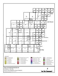
<strong>Town</strong> <strong>of</strong> <strong>Innisfil</strong> <strong>Official</strong> <strong>Plan</strong>LEFROY SECONDARY PLANnative plant species in consultation with LSRCA, as well as accommodate a trailsystem where appropriate.e) Lands required for stormwater management facilities shown on Schedule B3shall be dedicated, at no cost, to the municipality.f) The <strong>Town</strong> may consider the establishment <strong>of</strong> interim stormwater managementfacilities on a temporary basis within the Secondary <strong>Plan</strong> area, notwithstandingthe underlying land use designation for the lands, provided the interim facilitiesdo not preclude or prejudice future development on the basis <strong>of</strong> the land usedesignations shown on Schedule B3, and provided they are not located withinthe Natural Environmental Area designation.13.4 ENVIRONMENTAL MANAGEMENTAlthough lands have been designated for environmental protection in the NaturalEnvironmental Area designation, development outside <strong>of</strong> these areas can haveimplications for the environment and for public health and safety. The policies <strong>of</strong> thissection require additional consideration and study and possible mitigation throughdesign and prohibition <strong>of</strong> certain uses within areas <strong>of</strong> potential environmentalconcern.13.4.1 Greenlandsa) A portion <strong>of</strong> the Secondary <strong>Plan</strong> area is traversed by the ‘Greenland’ designationin the County <strong>of</strong> Simcoe <strong>Official</strong> <strong>Plan</strong>. The policies <strong>of</strong> the County <strong>of</strong> Simcoe<strong>Official</strong> <strong>Plan</strong> provide for the County Greenlands designation to be refined throughmore detailed investigations in the local municipal <strong>Official</strong> <strong>Plan</strong>. This Secondary<strong>Plan</strong> and supporting studies have refined the boundaries based on the NaturalEnvironmental Area designations and with the intent to maintain a north-southlinkage connection through Lefroy. The refined boundary is shown on ScheduleB3A.b) Existing development will be encouraged to maintain, enhance and augment theexisting natural features through the use <strong>of</strong> buffers, natural restoration, otheropen space and land stewardship in order to maintain the potential for plant andwildlife movement and dispersal.c) Density bonusing and transfers may be employed to encourage restoration,rehabilitation and land dedication <strong>of</strong> a linkage where appropriate.13.4.2 Hazard Landsa) Hazard Lands on Schedule B3 include lands potentially unsafe for developmentdue primarily to flood hazard but may also include erosion hazard and steepslopes. The floodplain <strong>of</strong> Carson Creek is included within the Hazard Landsboundary. For the undeveloped areas west <strong>of</strong> the rail corridor, the floodplain islocated within the Natural Environmental Area designation. However, there aresome existing lots and dwellings located east and west <strong>of</strong> the railway that arelocated within the floodplain.210Adopted July 26, 2006 <strong>Approved</strong> by <strong>OMB</strong> May 2009, March 2010 & April 8, 2011