Innisfil Official Plan OMB Approved - Town of Innisfil
Innisfil Official Plan OMB Approved - Town of Innisfil
Innisfil Official Plan OMB Approved - Town of Innisfil

Create successful ePaper yourself
Turn your PDF publications into a flip-book with our unique Google optimized e-Paper software.
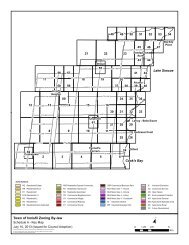
<strong>Town</strong> <strong>of</strong> <strong>Innisfil</strong> <strong>Official</strong> <strong>Plan</strong>LEFROY SECONDARY PLANb) The Lefroy Settlement Area shall consist <strong>of</strong> four residential neighbourhoodsfocused on a mixed use Core Commercial area along Killarney Beach Road.The rail line and Killarney Beach Road create the boundaries between the fourneighbourhoods.c) The rail line is also intended to provide travel service to the north and south. Theestablishment <strong>of</strong> a GO Transit station will provide commuter services forresidents to Barrie and Toronto and will provide the opportunity to create atransportation and transit hub within the <strong>Town</strong>.d) The Concept envisions a major open space area consisting <strong>of</strong> natural areas (e.g.streams, wooded areas), parks, conservation uses as well as providing for anintegrated pedestrian and cycling trail system.e) A trail system is conceptually delineated on Schedule C2. It is intended to linkparks, community facilities, natural environmental areas and stormwatermanagement ponds through open space lands and along public rights <strong>of</strong> way.f) Two “Gateway” opportunities exist at Killarney Beach Road and County Road 39and at Killarney Beach Road and Ewart Street. These gateways can provideidentity, visual improvement and superior urban streetscape and design.g) The Secondary <strong>Plan</strong> area shall achieve a housing mix <strong>of</strong> approximately 75%singles and semi-detached housing units and 25% townhouses and apartmentunits. Multi-unit housing forms shall be distributed in clusters throughout theSecondary <strong>Plan</strong> area.h) The urban design guidelines found in Section 13.8 <strong>of</strong> this Secondary <strong>Plan</strong> shallestablish an appropriate character for the Secondary <strong>Plan</strong> area and support theheritage character <strong>of</strong> the area.i) It is anticipated that the Secondary <strong>Plan</strong> area will provide for an additionalpopulation <strong>of</strong> approximately 4,500 people exclusive <strong>of</strong> infill by 2016 based on apersons per household rate <strong>of</strong> 2.9.13.3 LAND USE PLAN13.3.1 Generala) The Land Use designations for the Lefroy Secondary <strong>Plan</strong> area are identified onSchedule B3 - Land Use <strong>Plan</strong>, which should be read in conjunction with thepolicies <strong>of</strong> this Secondary <strong>Plan</strong>.b) Lands within the Lefroy Secondary <strong>Plan</strong> area will be primarily residential,consisting <strong>of</strong> a full range <strong>of</strong> housing opportunities and supporting facilitiesincluding schools, commercial facilities, places <strong>of</strong> worship, parks and open spaceareas.195Adopted July 26, 2006 <strong>Approved</strong> by <strong>OMB</strong> May 2009, March 2010 & April 8, 2011