Innisfil Official Plan OMB Approved - Town of Innisfil
Innisfil Official Plan OMB Approved - Town of Innisfil
Innisfil Official Plan OMB Approved - Town of Innisfil

Create successful ePaper yourself
Turn your PDF publications into a flip-book with our unique Google optimized e-Paper software.
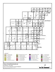
<strong>Town</strong> <strong>of</strong> <strong>Innisfil</strong> <strong>Official</strong> <strong>Plan</strong>COOKSTOWN SECONDARY PLAN11.2.7.3 Preliminary review undertaken by the <strong>Town</strong> and developers between 1995 and 2000suggest that expansion or upgrades to the Cookstown sewage treatment plant toaccommodate the second stage would be at significant cost and is not a realisticoption for the additional 1000 population (approximately 300 units), contemplated inthe foreseeable future. Given that only limited growth is contemplated for theCookstown area over the planning period, use <strong>of</strong> available reserve capacity toaccommodate additional growth has been considered.11.2.7.4 Through monitoring <strong>of</strong> actual usage <strong>of</strong> the sewage treatment plant, in accordance withguidelines accepted by the Ministry <strong>of</strong> the Environment plus 5% <strong>of</strong> the average dailyflow as an additional buffer, indications are that there is some available reservecapacity which will enable limited development as contemplated in the Stage 2allocations, without requiring an expansion to the sewage treatment plant. However toensure plant capacity is not exceeded, any development occurring beyond the Stage 1allocations shall be subject to the ongoing monitoring and implementation provisionsas set out in Section C to this section <strong>of</strong> the Cookstown Secondary <strong>Plan</strong>.11.2.7.5 The intent <strong>of</strong> this policy is to encourage growth and to ensure adequate support inregard to municipal services.11.2.7.6 The following subsections, in conjunction with map Schedule B2a - DevelopmentStaging <strong>Plan</strong>, set out the areas, type <strong>of</strong> uses and maximum development potentialpermitted. Section (A) deals with the residential development <strong>of</strong> large blocks <strong>of</strong> vacantlands; Section (B) deals with growth items such as apartments, infilling andconversions. Section (C) deals with policies for development to proceed on the basis<strong>of</strong> available Reserve Capacity.11.2.7.6 a Single Family Residential Development1. Area 1, as set out on Schedule B2a, is located generally south <strong>of</strong> Queen Street,west <strong>of</strong> Dufferin Street and north <strong>of</strong> Victoria Street, and consists <strong>of</strong> approximately3.74 hectares. Maximum allowable development is set at 15 single familyresidential units in the first phase and up to an additional 25 single familyresidential units in the second phase.2. Area 2, as set out on Schedule B2a, is located generally south <strong>of</strong> Victoria Street,west <strong>of</strong> King Street and north <strong>of</strong> the Village boundary and consists <strong>of</strong> approximately9.9 hectares. Maximum allowable development is set at 27 single familyresidential units in the first phase and up to an additional 58 single familyresidential units in the second phase. At this time it is not known if Evelyn Streetwill be continued into area 2 through area 7 and if portions <strong>of</strong> land in area 7 will betransferred to area 2. Should the street be continued and should parts <strong>of</strong> area 7be transferred to area 2 as a result <strong>of</strong> this extension, then, for the purpose <strong>of</strong> this<strong>Plan</strong>, those areas west <strong>of</strong> Evelyn Street extended, transferred from area 7 to area2, shall be deemed to be developable properties within area 2 and furthermore noamendment to this <strong>Plan</strong> or Schedule B2a will be required to reflect this change.3. Area 3, as set out on Schedule B2a, is located generally south <strong>of</strong> Victoria Street,east <strong>of</strong> King Street and north <strong>of</strong> the Village boundary and consists <strong>of</strong> approximately12 hectares. Maximum allowable development is set at 45 single family residential179Adopted July 26, 2006 <strong>Approved</strong> by <strong>OMB</strong> May 2009, March 2010 & April 8, 2011