To view a detailed project report click here - UNESCO Islamabad
To view a detailed project report click here - UNESCO Islamabad To view a detailed project report click here - UNESCO Islamabad
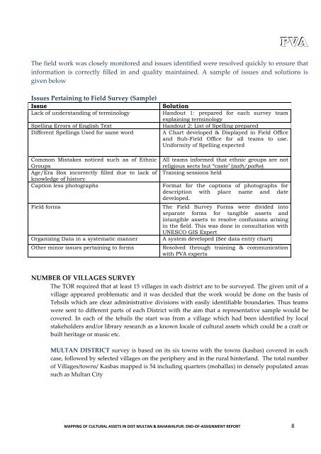
PVAThe field work was closely monitored and issues identified were resolved quickly to ensure thatinformation is correctly filled in and quality maintained. A sample of issues and solutions isgiven belowIssues Pertaining to Field Survey (Sample)IssueLack of understanding of terminologySpelling Errors of English TextDifferent Spellings Used for same wordCommon Mistakes noticed such as of EthnicGroupsAge/Era Box incorrectly filled due to lack ofknowledge of historyCaption less photographsField formsOrganizing Data in a systematic mannerOther minor issues pertaining to formsSolutionHandout 1: prepared for each survey teamexplaining terminologyHandout 2: List of Spelling preparedA Chart developed & Displayed in Field Officeand Sub-Field Office for all teams to use.Uniformity of Spelling expectedAll teams informed that ethnic groups are notreligious sects but “caste’ (zath/pathe)Training sessions heldFormat for the captions of photographs fordescription with place name and datedeveloped.The Field Survey Forms were divided intoseparate forms for tangible assets andintangible assets to resolve confusions arisingin the field. This was done in consultation withUNESCO GIS ExpertA system developed (See data entry chart)Resolved through training & communicationwith PVA expertsNUMBER OF VILLAGES SURVEYThe TOR required that at least 15 villages in each district are to be surveyed. The given unit of avillage appeared problematic and it was decided that the work would be done on the basis ofTehsils which are clear administrative divisions with easily identifiable boundaries. Thus teamswere sent to different parts of each District with the aim that a representative sample would becovered. In each of the tehsils the start was from a village which had been identified by localstakeholders and/or library research as a known locale of cultural assets which could be a craft orbuilt heritage or music etc.MULTAN DISTRICT survey is based on its six towns with the towns (kasbas) covered in eachcase, followed by selected villages on the periphery and in the rural hinterland. The total numberof Villages/towns/ Kasbas mapped is 54 including quarters (mohallas) in densely populated areassuch as Multan CityMAPPING OF CULTURAL ASSETS IN DIST MULTAN & BAHAWALPUR: END-OF-ASSIGNMENT REPORT 8
TABLE SHOWING THE VILLAGES MAPPED IN DISTRICT MULTANPVAS. N NAMES OF TOWN VILLAGES1. JALAL PUR TOWN 1. Khan Bella2. Ali Pur Sadaat3. Ghazi Pur4. Karam Ali Wala5. Kotla Chaker6. Umerpur2. SHAH RUKN -E-ALAM TOWN1. Shah Rukn-e-Alam Town City2. Jhooke Lashker Pur3. Makhdoom Rasheed4. Budhla Santt3. BOSAN TOWN 1. Qadir Pur Ran2. Bosan U.C.643. Salah Mahay4. Binda Sandeela4. SHER SHAH TOWN 1. Sher Shah Town City2. Hamid Pur Kanoora3. Qasba Sani4. Laar5. Rangeel Pur5. MUMTAZ ABADTOWN1. Mumtaz Abad Town City2. Said Pur3. Basti Malook4. 18-M / R5. Mumtaz Abad U.C.846. SHUJA ABAD TOWN 1. Shuja Abad Walled City2. Sikendar Abad3. Kotli Nejabat4. Jalal Pur Khakhi5. Jhallan Wala7. Basti Sheikh Ismaeel8. Moza Khanu9. Chack 82/M Basti Khuda Baksh10. Hafiz Wala11. Basti Behli Sharif12. Basti Dewala5. Loother6. Tattay Pur7. Sayedpur8. Sorajmiani5. Alamdi Surrah6. Bosan Town City7. Gulgisht Colony8. Basti Laber6. Kotla Toley Khan7. Aminbad8. Bajje Wala9. Tibbi Sher Khan Wala6. Khan Pur Marral7. Nawabpur8. Moza Balochan9. Lakhi Wala10. Chah Said Wala6. Noushehra Panjani7. Bulel8. Gardezpur9. Chanbi Wala10. Moza JhakkarTOTAL VILLAGES/TOWNS/KASBAS 54BAHAWALPUR DISTRICT mapping represents all tehsils and total as 65village/kasbas/mohallas.During the Bahawalpur mapping, the team was able to record some songs of the riverside tribesalong the Sutlej and it was decided that a team would be dispatched to map tribes along theriverside. A unique cache of intangible assets were mapped, a selection of which has beenproduced as a DVD. In Bahawalpur district it was also decided to go into Deep Cholistan sincethe periphery villages had revealed such unique and exquisite assets it was felt that the moreremote parts would perhaps be important to record. (See The Strategy Report -Part 1: Findings ofthe Project). The Table below encapsulates the villages mapped during the ProjectMAPPING OF CULTURAL ASSETS IN DIST MULTAN & BAHAWALPUR: END-OF-ASSIGNMENT REPORT 9
- Page 1 and 2: PVAopasdfghjklzxcvbnmqwertyuiopasdf
- Page 3 and 4: 3. STAGES OF WORK, OUTPUTS AND OUTC
- Page 5 and 6: TABLE 2: TRAINING DURING PROJECT PE
- Page 7: ) FIELD SURVEY AND GIS DATABASEPVAT
- Page 11 and 12: DATA ENTRY IN GIS DATABASEThis invo
- Page 13 and 14: 1 Introduction -Background & Method
- Page 15 and 16: PVAANNEX1. Terms of Reference & Out
- Page 17 and 18: PVAANNEX 2SAMPLEBAHAWALPUR- Quality
- Page 19 and 20: PVAFormIDSite Name Settlement Kind
- Page 21 and 22: Wali2063 Shah Machine Multan Mound
- Page 23 and 24: PVAANNEX 5: List of Built Assets, D
- Page 25 and 26: Alsadiq1007 Sadiq Dain HighSchoolBa
- Page 27 and 28: PVAbe maintained in permanent good
- Page 29: PVA14 2740 Textile Jalalpur(Meer Ko
PVAThe field work was closely monitored and issues identified were resolved quickly to ensure thatinformation is correctly filled in and quality maintained. A sample of issues and solutions isgiven belowIssues Pertaining to Field Survey (Sample)IssueLack of understanding of terminologySpelling Errors of English TextDifferent Spellings Used for same wordCommon Mistakes noticed such as of EthnicGroupsAge/Era Box incorrectly filled due to lack ofknowledge of historyCaption less photographsField formsOrganizing Data in a systematic mannerOther minor issues pertaining to formsSolutionHandout 1: prepared for each survey teamexplaining terminologyHandout 2: List of Spelling preparedA Chart developed & Displayed in Field Officeand Sub-Field Office for all teams to use.Uniformity of Spelling expectedAll teams informed that ethnic groups are notreligious sects but “caste’ (zath/pathe)Training sessions heldFormat for the captions of photographs fordescription with place name and datedeveloped.The Field Survey Forms were divided intoseparate forms for tangible assets andintangible assets to resolve confusions arisingin the field. This was done in consultation with<strong>UNESCO</strong> GIS ExpertA system developed (See data entry chart)Resolved through training & communicationwith PVA expertsNUMBER OF VILLAGES SURVEYThe TOR required that at least 15 villages in each district are to be surveyed. The given unit of avillage appeared problematic and it was decided that the work would be done on the basis ofTehsils which are clear administrative divisions with easily identifiable boundaries. Thus teamswere sent to different parts of each District with the aim that a representative sample would becovered. In each of the tehsils the start was from a village which had been identified by localstakeholders and/or library research as a known locale of cultural assets which could be a craft orbuilt heritage or music etc.MULTAN DISTRICT survey is based on its six towns with the towns (kasbas) covered in eachcase, followed by selected villages on the periphery and in the rural hinterland. The total numberof Villages/towns/ Kasbas mapped is 54 including quarters (mohallas) in densely populated areassuch as Multan CityMAPPING OF CULTURAL ASSETS IN DIST MULTAN & BAHAWALPUR: END-OF-ASSIGNMENT REPORT 8


