Walking Guide 3 - Dearne Valley Park - Barnsley Council Online
Walking Guide 3 - Dearne Valley Park - Barnsley Council Online
Walking Guide 3 - Dearne Valley Park - Barnsley Council Online
- No tags were found...

You also want an ePaper? Increase the reach of your titles
YUMPU automatically turns print PDFs into web optimized ePapers that Google loves.
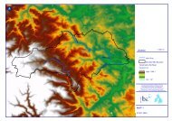
e ACTIVE CHOOSE WALKING<strong>Walking</strong> <strong>Guide</strong> 3DEARNE VALLEY PARKStarting Point: <strong>Dearne</strong> <strong>Valley</strong> <strong>Park</strong>,Hoyle Mill.Distance: 2.1 miles (3.2 km).Grade of difficulty: Easy/Moderate.Time: Allow yourself 1¼ hrs.<strong>Dearne</strong> <strong>Valley</strong> <strong>Park</strong>, Hoyle MillInformation in this walking guide can be made available inlarge print. This route has been assessed for mobility andsensory impaired users. Please be aware that some pathsare uneven and stoney, and go up and down slopes.For further information please contact BMBC Planning andTransportation Service on 01226 772655.Information is correct at time of printing - March 2008.1 Start from <strong>Dearne</strong> <strong>Valley</strong> <strong>Park</strong>, Pontefract Road. From thecar park bear left along the tarmac path keeping the River<strong>Dearne</strong> to your right. 2 At the junction of paths, bear leftuphill to join the former canal tow path. 3 Bear sharp rightalong the path heading towards the footbridge on the site ofthe <strong>Barnsley</strong> Canal Aqueduct. 4 Before the footbridge bearright down the sloping path. 5 At the junction of paths, turnleft heading towards the bridge over the river; cross overthen turn right heading towards the ‘dam head crossing’.6 Continue on, keeping the lakes to your left. 7 At thejunction, bear left then cross the small bridge. 8 Bear left,following the path around the lake heading towards the ‘damhead crossing’. 9 Bear right, up the wide stone pathheading towards the nearby settlement. 10 Bear left, alongthe path heading towards the <strong>Barnsley</strong> Canal Aqueduct.11 Bear left, before the footbridge; go through a woodedarea heading back towards the lake and the start of yourwalk. You may go over the ‘dam head crossing’ if passable;otherwise follow the route back around the lake, to the carpark up a flight of steps or ramp.BARNSLEYMetropolitan Borough <strong>Council</strong>be ACTIVE CHOOSE WALKING
e ACTIVE CHOOSE WALKING be ACTIVE CHOOSE WALKINGbe ACTIVE CHOOSE WALKING4Not to scale11310295 6 78Reproduced from the Ordnance Survey mapping with the permission of Her Majesty’s Stationery Office C Crown Copyright. Unauthorised reproduction infringes Crown Copyright and may lead to prosecution or civil proceedings.<strong>Barnsley</strong> Metropolitan Borough <strong>Council</strong>, Licence number 100022264.be ACTIVE CHOOSE WALKING be ACTIVE CHOOSE WALKING1be ACTIVE CHOOSE WALKING