The Soils of Elgin County - Agriculture and Agri-Food Canada
The Soils of Elgin County - Agriculture and Agri-Food Canada The Soils of Elgin County - Agriculture and Agri-Food Canada
Procedure :1) Locate the symbols 'BV" and "TA" in the firstcolumn of Table 4 titled 'Map Symbol".2) Determine the appropriate slope class columnsby locating slope class 'b" and slope class "c"which appear under the heading titled"Capability classification by slope classes".3) The soil capability ratings for the soilsidentified in the symbol are shown where thehorizontal lines and vertical columns intersect.Therefore, the capability rating for BV soilswhich occur on b slopes is 2D, and thecapability rating for TA soils which occur on cslopes is 2T .4) The soil capability rating for the map symbolis 2D>2T.Example 5.AL, ER, SC, or VCThese symbols represent miscellaneous landunits. In Table 4, a capability rating is given foreach of these units which is the range of soilcapabilities that generally occur in all areas wherethese land units were identified. The capabilitiesof the soils within individual areas mapped asthese land units, therefore, may vary . Forexample, two areas may be identified on one ofthe soil maps. as Alluvium (AL), and both arerated Class 31 to 51 in Table 4 . One of the areas,however, may be composed entirely of soils whichhave a capability of Class 31. The other area maybe composed entirely of soils which have acapability of Class 51.
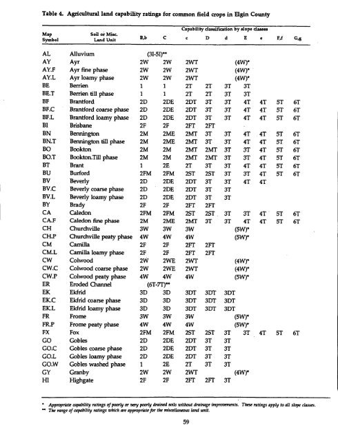
Table 4.Agricultural land capability ratings for common field crops in Elgin CountyMapSymbolSoil or Misc .Land UnitB,bCCapability classification by slope classesc D d E e F,f G,gAL Alluvium (31-5I)**AY Ayr 2W 2W 2WT (4W)*AY.F Ayr fine phase 2W 2W 2WT (4W)*AY.L Ayr loamy phase 2W 2W 2WT (4W)*BE Berrien 1 1 2T 2T 3T 3TBE .T Berrien till phase 1 1 2T 2T 3T 3TBF Brantford 2D 2DE 2DT 3T 3T 4T 4T 5T 6TBF.C Brantford coarse phase 2D 2DE 2DT 3T 3T 4T 4T 5T 6TBF.L Brantford loamy phase 2D 2DE 2DT 3T 3T 4T 4T 5T 6TBI Brisbane 2F 2F 2FT 2FTBN Bennington 2M 2ME 2MT 3T 3T 4T 4T 5T 6TBN .T Bennington till phase 2M 2ME 2MT 3T 3T 4T 4T 5T 6TBO Bookton 2M 2M 2MT 2MT 3T 3T 4T 5T 6TBO.T Bookton.Till phase 2M 2M 2MT 2MT 3T 3T 4T 5T 6TBT Brant 1 2E 2T 3T 3T 4T 4T 5T 6TBU Burford 2FM 2FM 2ST 2ST 3T 3T 4T 5T 6TBV Beverly 2D 2DE 2DT 3T 3T 4T 4TBV .C Beverly coarse phase 2D 2DE 2DT 3T 3TBV.L Beverly loamy phase 2D 2DE 2DT 3T 3TBY Brady 2F 2F 2Fr 2FTCA Caledon 2FM 2FM 2ST 2ST _ 3T 3T 4T - 5T 6TCA .F Caledon fine phase 2M 2ME 2MT 3T 3T 4T 4T 5T 6TCH Churchville 3W 3W 3W (5W)*CH.P Churchville peaty phase 4W 4W 4W (5W)*CM Camilla 2F 2F 2FT 2FTCM.L Camilla loamy phase 2F 2F 2FT 2FTCW Colwood 2W 2WE 2WT (4W)*CW.C Colwood coarse phase 2W 2WE 2WT (4W)*CW .P Colwood peaty phase 4W 4W 4W (5W)*ER Eroded Channel (6T-7T)**EK Ekfrid 3D 3D 3DT 3DT 3DTEK.C Ekfrid coarse phase 3D 3D 3DT 3DT 3DTEK.L Ekfrid loamy phase 3D 3D 3DT 3DT 3DTFR Frome 3W 3W 3W (5W)*FRY Frome peaty phase 4W 4W 4W (5W)*FX Fox 2FM 2FM 2ST 2ST 3T 3T 4T 5T 6TGO Gobles 2D 2DE 2DT 3T 3TGO.C Gobles coarse phase 2D 2DE 2DT 3T 3TGO.L Gobles loamy phase 2D 2DE 2DT 3T 3TGO.W Gobles washed phase 1 2E 2T 3T 3TGY Granby 2W 2W 2WT (4W)*HI Highgate 2F 2F 2FT 2FT 3T' Appropriate capability ratings of poorly or very poorly drained soils without drainage improvements. These ratings apply to all slope classes .w The range of capability ratings which are appropriate for the miscellaneous land unit.59
- Page 9 and 10: 5. More detailed information for a
- Page 11 and 12: Table 1 .Climate data for Elgin Cou
- Page 13 and 14: Figure 4.Generalized geologic map o
- Page 15 and 16: Table 2.Correlation of major soils
- Page 17 and 18: Figure 6.Schematic landscape cross-
- Page 19 and 20: HOW THE SOILS WERE MAPPED AND CLASS
- Page 21 and 22: of soil profiles and horizons which
- Page 23 and 24: GENERAL DESCRIPTIONS OF THE SOILSSo
- Page 25 and 26: Table 3.Soils and land units mapped
- Page 27 and 28: Figure 11 .Soil textural groups and
- Page 29 and 30: phase (BN.T) soils were mapped in c
- Page 31 and 32: underlying fine textured materials
- Page 33 and 34: atings for selected special crops a
- Page 35 and 36: Conservation tillage practices, par
- Page 37 and 38: clay. The Ap horizons commonly have
- Page 39 and 40: Gobles soils were frequently mapped
- Page 41 and 42: Kelvin soils are susceptible to com
- Page 43 and 44: Soil Moisture CharacteristicsMiddle
- Page 46 and 47: soils which occur in the eastern po
- Page 48 and 49: Bluish gray or gray gley colours ar
- Page 50 and 51: Stanley till, Tavistock till phase
- Page 52 and 53: to neutral in the Ap horizons, to m
- Page 54 and 55: tillage practices, particularly no-
- Page 56 and 57: Organic (OR)Organic land units usua
- Page 58 and 59: eference and also Publication No .
- Page 62 and 63: Table 4.Agricultural alnd capabilit
- Page 64 and 65: Soil Suitability ClassesDescription
- Page 66 and 67: Procedure:1) Locate the symbols 'BV
- Page 68 and 69: Table 6.Agricultural land suitabili
- Page 70 and 71: Table 6.Agricultural land suitabili
- Page 72 and 73: Table 6 .Agricultural land suitabil
- Page 74 and 75: Table 6 .Agricultural land suitabil
- Page 76 and 77: Table 6. Agricultural land suitabil
- Page 78 and 79: Table 6.Agricultural land suitabili
- Page 80 and 81: Table 7.Agricultural land suitabili
- Page 82 and 83: Table 7.Agricultural land suitabili
- Page 84 and 85: Table 7. Agricultural land suitabil
- Page 86 and 87: Table 7.Agricultural land suitabili
- Page 88 and 89: Table 7. Agricultural land suitabil
- Page 90 and 91: Table 7.Agricultural land suitabili
- Page 92 and 93: Table 8.Agricultural land suitabili
- Page 94 and 95: Table 8.Agricultural land suitabili
- Page 96 and 97: Table 8. Agricultural land suitabil
- Page 98 and 99: Table 8 .Agricultural land suitabil
- Page 100 and 101: Table 8.Agricultural land suitabili
- Page 102 and 103: Table 8 .Agricultural land suitabil
- Page 104 and 105: Table 8 .Agricultural land suitabil
- Page 106 and 107: erosion losses will occur . Potenti
- Page 108 and 109: the average annual soil loss using
Table 4.<strong>Agri</strong>cultural l<strong>and</strong> capability ratings for common field crops in <strong>Elgin</strong> <strong>County</strong>MapSymbolSoil or Misc .L<strong>and</strong> UnitB,bCCapability classification by slope classesc D d E e F,f G,gAL Alluvium (31-5I)**AY Ayr 2W 2W 2WT (4W)*AY.F Ayr fine phase 2W 2W 2WT (4W)*AY.L Ayr loamy phase 2W 2W 2WT (4W)*BE Berrien 1 1 2T 2T 3T 3TBE .T Berrien till phase 1 1 2T 2T 3T 3TBF Brantford 2D 2DE 2DT 3T 3T 4T 4T 5T 6TBF.C Brantford coarse phase 2D 2DE 2DT 3T 3T 4T 4T 5T 6TBF.L Brantford loamy phase 2D 2DE 2DT 3T 3T 4T 4T 5T 6TBI Brisbane 2F 2F 2FT 2FTBN Bennington 2M 2ME 2MT 3T 3T 4T 4T 5T 6TBN .T Bennington till phase 2M 2ME 2MT 3T 3T 4T 4T 5T 6TBO Bookton 2M 2M 2MT 2MT 3T 3T 4T 5T 6TBO.T Bookton.Till phase 2M 2M 2MT 2MT 3T 3T 4T 5T 6TBT Brant 1 2E 2T 3T 3T 4T 4T 5T 6TBU Burford 2FM 2FM 2ST 2ST 3T 3T 4T 5T 6TBV Beverly 2D 2DE 2DT 3T 3T 4T 4TBV .C Beverly coarse phase 2D 2DE 2DT 3T 3TBV.L Beverly loamy phase 2D 2DE 2DT 3T 3TBY Brady 2F 2F 2Fr 2FTCA Caledon 2FM 2FM 2ST 2ST _ 3T 3T 4T - 5T 6TCA .F Caledon fine phase 2M 2ME 2MT 3T 3T 4T 4T 5T 6TCH Churchville 3W 3W 3W (5W)*CH.P Churchville peaty phase 4W 4W 4W (5W)*CM Camilla 2F 2F 2FT 2FTCM.L Camilla loamy phase 2F 2F 2FT 2FTCW Colwood 2W 2WE 2WT (4W)*CW.C Colwood coarse phase 2W 2WE 2WT (4W)*CW .P Colwood peaty phase 4W 4W 4W (5W)*ER Eroded Channel (6T-7T)**EK Ekfrid 3D 3D 3DT 3DT 3DTEK.C Ekfrid coarse phase 3D 3D 3DT 3DT 3DTEK.L Ekfrid loamy phase 3D 3D 3DT 3DT 3DTFR Frome 3W 3W 3W (5W)*FRY Frome peaty phase 4W 4W 4W (5W)*FX Fox 2FM 2FM 2ST 2ST 3T 3T 4T 5T 6TGO Gobles 2D 2DE 2DT 3T 3TGO.C Gobles coarse phase 2D 2DE 2DT 3T 3TGO.L Gobles loamy phase 2D 2DE 2DT 3T 3TGO.W Gobles washed phase 1 2E 2T 3T 3TGY Granby 2W 2W 2WT (4W)*HI Highgate 2F 2F 2FT 2FT 3T' Appropriate capability ratings <strong>of</strong> poorly or very poorly drained soils without drainage improvements. <strong>The</strong>se ratings apply to all slope classes .w <strong>The</strong> range <strong>of</strong> capability ratings which are appropriate for the miscellaneous l<strong>and</strong> unit.59


