Storm Water Pollution Prevention Plan (SWPPP) - the City of Lompoc!
Storm Water Pollution Prevention Plan (SWPPP) - the City of Lompoc!
Storm Water Pollution Prevention Plan (SWPPP) - the City of Lompoc!

You also want an ePaper? Increase the reach of your titles
YUMPU automatically turns print PDFs into web optimized ePapers that Google loves.
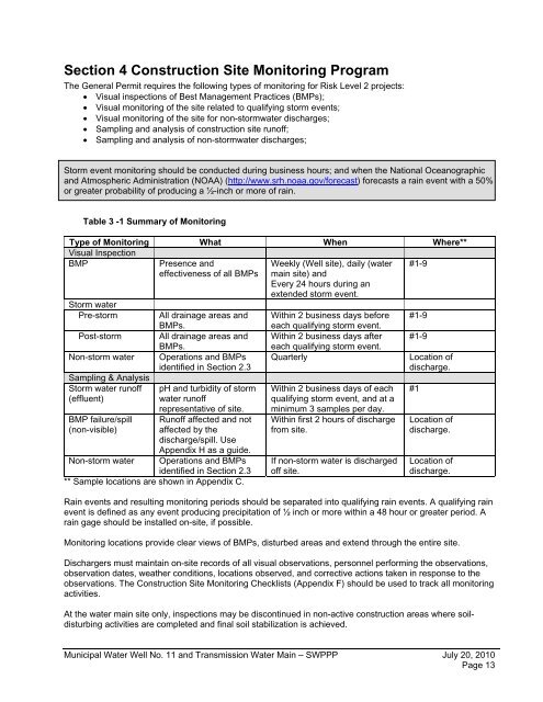
Section 4 Construction Site Monitoring ProgramThe General Permit requires <strong>the</strong> following types <strong>of</strong> monitoring for Risk Level 2 projects:• Visual inspections <strong>of</strong> Best Management Practices (BMPs);• Visual monitoring <strong>of</strong> <strong>the</strong> site related to qualifying storm events;• Visual monitoring <strong>of</strong> <strong>the</strong> site for non-stormwater discharges;• Sampling and analysis <strong>of</strong> construction site run<strong>of</strong>f;• Sampling and analysis <strong>of</strong> non-stormwater discharges;<strong>Storm</strong> event monitoring should be conducted during business hours; and when <strong>the</strong> National Oceanographicand Atmospheric Administration (NOAA) (http://www.srh.noaa.gov/forecast) forecasts a rain event with a 50%or greater probability <strong>of</strong> producing a ½-inch or more <strong>of</strong> rain.Table 3 -1 Summary <strong>of</strong> MonitoringType <strong>of</strong> Monitoring What When Where**Visual InspectionBMP#1-9<strong>Storm</strong> waterPre-stormPost-stormNon-storm waterSampling & Analysis<strong>Storm</strong> water run<strong>of</strong>f(effluent)BMP failure/spill(non-visible)Non-storm waterPresence andeffectiveness <strong>of</strong> all BMPsAll drainage areas andBMPs.All drainage areas andBMPs.Operations and BMPsidentified in Section 2.3pH and turbidity <strong>of</strong> stormwater run<strong>of</strong>frepresentative <strong>of</strong> site.Run<strong>of</strong>f affected and notaffected by <strong>the</strong>discharge/spill. UseAppendix H as a guide.Operations and BMPsidentified in Section 2.3** Sample locations are shown in Appendix C.Weekly (Well site), daily (watermain site) andEvery 24 hours during anextended storm event.Within 2 business days beforeeach qualifying storm event.Within 2 business days aftereach qualifying storm event.QuarterlyWithin 2 business days <strong>of</strong> eachqualifying storm event, and at aminimum 3 samples per day.Within first 2 hours <strong>of</strong> dischargefrom site.If non-storm water is discharged<strong>of</strong>f site.#1-9#1-9Location <strong>of</strong>discharge.#1Location <strong>of</strong>discharge.Location <strong>of</strong>discharge.Rain events and resulting monitoring periods should be separated into qualifying rain events. A qualifying rainevent is defined as any event producing precipitation <strong>of</strong> ½ inch or more within a 48 hour or greater period. Arain gage should be installed on-site, if possible.Monitoring locations provide clear views <strong>of</strong> BMPs, disturbed areas and extend through <strong>the</strong> entire site.Dischargers must maintain on-site records <strong>of</strong> all visual observations, personnel performing <strong>the</strong> observations,observation dates, wea<strong>the</strong>r conditions, locations observed, and corrective actions taken in response to <strong>the</strong>observations. The Construction Site Monitoring Checklists (Appendix F) should be used to track all monitoringactivities.At <strong>the</strong> water main site only, inspections may be discontinued in non-active construction areas where soildisturbingactivities are completed and final soil stabilization is achieved.Municipal <strong>Water</strong> Well No. 11 and Transmission <strong>Water</strong> Main – <strong>SWPPP</strong> July 20, 2010Page 13