PARADISE PARK RESERVOIR - Division of Water Quality
PARADISE PARK RESERVOIR - Division of Water Quality
PARADISE PARK RESERVOIR - Division of Water Quality

Create successful ePaper yourself
Turn your PDF publications into a flip-book with our unique Google optimized e-Paper software.
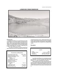
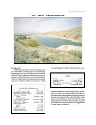
<strong>PARADISE</strong> <strong>PARK</strong> <strong>RESERVOIR</strong><strong>PARADISE</strong> <strong>PARK</strong> <strong>RESERVOIR</strong>IntroductionParadise Park Reservoir is an intermediate sizereservoir on the south slope <strong>of</strong> the High Uintas. It is at theterminus <strong>of</strong> a well maintained gravel road with acampground by the reservoir. It has a small, naturalwatershed and provides hiking opportunities. ParadisePark Reservoir was created in 1924 by the construction <strong>of</strong>an earth-fill dam. The reservoir shoreline is owned by theAshley National Forest, and public access is unrestricted.Characteristics and MorphometryLake elevation (meters / feet) 3,036 / 9,958Surface area (hectares / acres) 57.8 / 143<strong>Water</strong>shed area (hectares / acres) 996 / 2,461Volume (m 3 / acre-feet)capacity 3,870,000 / 3,135conservation pool 0Annual inflow (m 3 / acre-feet)Retention time (years)Drawdown (m 3 / acre-feet)Depth (meters / feet)maximum 11.28 / 37mean 6.09 / 20Length (meters / feet) 1,220 / 4,000Width (meters / feet) 610 / 2,000Shoreline (km / miles) 2.97 / 1.8Reservoir water is consumed entirely for irrigation. Fiftypercent <strong>of</strong> the volume <strong>of</strong> the reservoir is drained <strong>of</strong>f beforemid-summer for agricultural purposes and the remaining50% is retained as a conservation pool. <strong>Water</strong> use is notexpected to change in the foreseeable future.RecreationLocationCountyUintaLongitude / Latitude 109 54 56 / 40 40 04USGS Map Paradise Park 1965DeLorme's Utah Atlas & Gazetteer TM Page 56, B-1Cataloging Unit Duchesne River (14060003)Paradise Park Reservoir is north <strong>of</strong> LaPoint in theUinta Basin. From U-121 in LaPoint, go north on a pavedroad for about seven miles to a fork, take the left fork. Asthe pavement ends and leaves the Uinta and Ouray IndianReservation it enters the National Forest, becoming FS-104. The reservoir is about 16 miles into the NationalForest. The route is well marked, but the road at times isv e r y r o u g h
LAKE REPORTSFile Contains Data forPostScript Printers Only
<strong>PARADISE</strong> <strong>PARK</strong> <strong>RESERVOIR</strong>due to washboard development in the road.Fishing, boating, swimming, camping, picnicking, andhiking are all popular. While there are no boat ramps, it isgenerally possible to get a boat on the reservoir. TheUSFS recommends that boats be less than 14' long.Recreational facilities at the reservoir include aParadise Park Campground, a USFS facility, which hasprimitive latrines, picnic areas, and 15 campsites. Usagefees are not charged.Limnological AssessmentThe water quality <strong>of</strong> Paradise Park Reservoir is verygood. It is considered to be very s<strong>of</strong>t with a hardnessconcentration value <strong>of</strong> approximately 7 mg/L (CaCO3).The parameters that have exceeded State water qualitystandards for defined beneficial uses are dissolvedoxygen and pH. Dissolved oxygen concentrations in latesummer substantiate the fact that water qualityimpairments do exist. Concentrations droppeddramatically in the hypolimnion. The pr<strong>of</strong>ile <strong>of</strong> September4, 1991 indicates that stratified conditions may haveexisted earlier in the summer when the depth <strong>of</strong> thereservoir was greater. These low levels <strong>of</strong> dissolvedoxygen indicate that there is a substantial demand foroxygen at the sediment-water interface. Although thismay not create a problem for the fishery during theproductivity season, depletion <strong>of</strong> the dissolved oxygenduring winter months may be extensive enough to impairthe fishery.<strong>Water</strong>shed DescriptionParadise Park Reservoir is located in the High Uintas.It is an impoundment <strong>of</strong> Paradise Creek, a tributary to theWhiterocks River. The watershed consists entirely <strong>of</strong>alpine meadows and coniferous forests. Slopessurrounding the reservoir are not particularly steep(
LAKE REPORTSCurrent data suggest that the reservoir is currently anitrogen limited system. TSI values indicate the reservoiris mesotrophic but this may be skewed higher than it reallyis due to the elevated transparency TSI value. Thephosphorus and chlorophyll-a concentrations are relativelylow at 5 and 2.2 ug/L respectively. The high transparencyTSI value may be due to increased turbidity from theshallowness <strong>of</strong> the reservoir. The reservoir is probablyupper oligotrophic to low mesotrophic.According to DWR no fish kills have been reported inrecent years. The reservoir supports populations <strong>of</strong> brooktrout (Salvelinus fontinalis), rainbow trout(Oncorhynchus mykiss), and cutthroat trout(Oncorhynchus clarki). The lake has not been treatedfor rough fish competition, so populations <strong>of</strong> native fishesmay still be present in the lake. Current stocking reportsindicate that DWR stocks the reservoir with 5,000catchable rainbow trout and 7,000 fingerling brook trout.D o C pH DOCond0 15.5 8.2 7.7 241 15.5 7.7 7.6 232 15.4 7.4 7.5 243 15.4 7.4 7.4 244 14.7 7.1 7.0 245 14.1 6.8 6.5 246 12.0 6.2 2.0 266.6 11.6 6.0 1.7 29watershed.Beneficial Use ClassificationThe state beneficial use classifications include:boating and similar recreation (excluding swimming) (2B),cold water game fish and organisms in their food chain(3A) and agricultural uses (4).InformationManagement AgenciesUinta Basin Association <strong>of</strong> Governments 722-4518<strong>Division</strong> <strong>of</strong> Wildlife Resources 538-4700<strong>Division</strong> <strong>of</strong> <strong>Water</strong> <strong>Quality</strong> 538-6146Ashley National Forest 789-1181Vernal Ranger District 789-1181RecreationDinosaurland Travel Region (Vernal) 789-6932Vernal Chamber <strong>of</strong> Commerce 789-1352Reservoir AdministratorsWhiterocks Irrigation Company 247-2327TempDOPhytoplankton in the euphotic zone include thefollowing taxa (in order <strong>of</strong> dominance)SpeciesCell Volume% Density(mm 3 /liter) By VolumeSpherical green alga 0.008 37.47Oocystis sp. 0.008 35.13Pennate diatoms 0.003 14.05Centric diatoms 0.003 13.35Total 0.022Shannon-Weaver [H'] 1.28Species Evenness 0.92Species Richness 0.18The phytoplankton community is dominated by greenalgae and diatoms indicative <strong>of</strong> low productivity and goodwater quality.Pollution AssessmentNonpoint pollution sources include gazing andrecreation. Each summer, 400 cattle gaze in the area andon the shore line <strong>of</strong> the reservoir.There are no point sources <strong>of</strong> pollution in the
<strong>PARADISE</strong> <strong>PARK</strong> <strong>RESERVOIR</strong>