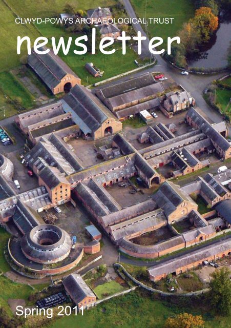
Spring 2011 issue - Clwyd-Powys Archaeological Trust
Spring 2011 issue - Clwyd-Powys Archaeological Trust
Spring 2011 issue - Clwyd-Powys Archaeological Trust

You also want an ePaper? Increase the reach of your titles
YUMPU automatically turns print PDFs into web optimized ePapers that Google loves.
Change of address . . .Towards the end of March the <strong>Trust</strong> movedinto new rented premises at 41 BroadStreet Welshpool, about midway between itsformer offices in Church Street and the HighStreet. As well as bringing the whole of the<strong>Trust</strong> under one roof our new premises providemuch better access and facilities for the publicand much needed storage.We are quite easy to find, opposite the townhall next to the offices of the MontgomeryshireWildlife <strong>Trust</strong>. The building never seems tohave had a number on the outside and insteadhas the date of 1816 prominently displayedabove the door. The building, a former branchof Lloyd’s Bank, lies on the site of a bank setup by Robert Griffiths during the 1780s, laterrenamed the Montgomeryshire Old Bank. Intime, the <strong>Trust</strong> will no doubt begin to stamp itsown identity on the history of the building.The move, which is in effect our first movesince we were set up thirty-six years ago,provides an opportunity to look again atour aims and objectives, as set out on thepage opposite. Due to the current climateof financial austerity we will inevitablybe forced have to cut-back on some of ouractivities — perhaps particularly on oureducation and outreach work — thoughhopefully we will be able to return to theseonce the economy begins to recover.our aims . . .The <strong>Trust</strong> is one of the fourWelsh <strong>Archaeological</strong> <strong>Trust</strong>s,working closely with othernational, regional and localbodies to help protect, recordand interpret all aspects of thehistoric environment for thewhole of Wales.In the other three panes wesummarize some of the ways inwhich we try to carry out ouraims.protectWe help to protect the historicenvironment by• working with localauthorities and otheragencies to monitor theimpact of development• providing strategicplanning advice at local andnational levels• providing informationand advice about sitemanagement andconservation <strong>issue</strong>sThe <strong>Trust</strong>’s newoffices at 41 BroadStreet, Welshpool,just oppositethe Town Hall.Below Banknote<strong>issue</strong>d by theMontgomeryshireOld Bank in 1814.recordWe help to record the historicenvironment by• maintaining the regionalHistoric EnvironmentRecord which includesphotographic, drawn andwritten records• undertaking survey andexcavation projects,particularly of sites underthreat• recording finds made bydetectorists and members ofthe general publicinterpretWe help to interpret the historicenvironment by• providing informationabout sites and findsof archaeological andhistorical interest• mounting exhibitions anddisplays, undertakingguided walks and talks, andpublishing reports aboutour work• providing work experienceand employment trainingopportunities2 3
On Denbigh Moors . . .Just published! This well-illustrated, bilingual volume about the Denbigh Moors — MynyddHiraethog — has just been published by the Royal Commission on the Ancient andHistorical Monuments of Wales in collaboration with the <strong>Trust</strong> and written byBob Silvester, the <strong>Trust</strong>’s Deputy Director. Based on theCommission’s Uplands Survey Initiative, thevolume tells the history of this distinctiveupland area south of Denbigh.Despite its often harsh and challenginglandscape the moors have been exploitedby people over many millennia. The storytakes in Mesolithic hunter-gatherers, BronzeAge chieftains, Iron Age, medieval andpost-medieval farmers, as well as more recentpressures posed by 20th- and 21st-centuryreservoirs, conifer plantations and windfarms.The book recently published by theRoyal Commission in the DiscoveringUpland Heritage series. See theCommission’s website for furtherdetails (www. rcahmw.gov.uk)Above The 20th-century AlwenReservoir, snaking its way across themoor. Mesolithic stone implementshave been found below some of themoor’s reservoirs during periodsof low water. Left Reconstructiondrawing of the post-medieval summerhouses at Hafod y Nant Criafolenexcavated in the 1970s in advanceof the construction of the BrenigReservoir by the Rescue ArchaeologyGroup — the forerunner of the <strong>Trust</strong>.The illustration is from the originalpublication in the Post-MedievalArchaeology journal.4 5Above left In the foreground is the enclosureknown as Hen Ddinbych (‘Old Denbigh’)which seems likely to have been the focus ofa sheep farm forming part of the estate ofthe medieval bishops of Bangor. Towardsthe middle right of the image is just visiblethe Brenig platform cairn with Llyn Brenigreservoir beyond The Bronze Age platformcairn was excavated in the 1970s as part of therescue campaign organised by Frances Lynch,The <strong>Trust</strong>’s current chairman, in advance ofthe construction of the reservoir. Below leftOne of the smaller Bronze Age cairns thatwere examined in the 1970s. This one wasfound to cover a cremation burial placed in acentral stone-lined cist.
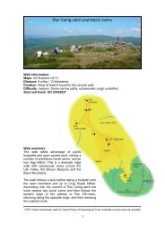
Historic landscape walksAseries of self-guided historic landscapewalks on open-access land is nowavailable on the <strong>Trust</strong>’s website (www.cpat.org.uk/walks/index.htm). The guides givedetails (see example on pages 8–9) of whereyou can park, sites of interest that you cansee on the walk, plus an indication of howlong the walk might take and how strenuousit is. The first series of walks, shown on themap below, focus on the recent survey ofprehistoric burial and ritual sites funded byCadw, including sites such a stone circles,standing stones and burial cairns largelydating to the Bronze Age (between about2300–1200 BC), but also draw attention tosites of other periods that can be seen on thewalk. It is hoped that in time walks lookingat sites of other periods will be added to thelist.Opposite The Moel Ty Uchaf stone circle,south of Llandrillo, Denbighshire, which isthe focus of one of the self-guided walks.Historic landscape walksin the <strong>Clwyd</strong>-<strong>Powys</strong> areaNote that the downloadableguides should always be used inconjunction with a suitable map,such as the Ordnance Survey1:25,000 Explorer or OutdoorLeisure series. A GPS andcompass may also be useful. Thewalks will take you into remoteupland areas and you should makesure that you are well equippedand have checked a weatherforecast before setting out.DenbighWelshpool1 Gop Cairn2 Llyn Brenig3 Llantysilio Mountain4 Eglwyseg5 Moel Ty Uchaf6 Trannon7 Corndon8 Gro Hill9 Gors Lydan10 Bache Hill11 Nant Tarw12 Mynydd Llangorse13 Pen Cerrig-calchBrecon6 7
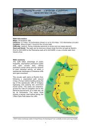
Eglwyseg MountainMaps Ordnance Survey Explorer 256Distance 5.3 miles / 8.5 kilometres (linear) or up to 9.6 miles / 15.5 kilometres (circular)Duration Allow at least 7 hours for the circular walkDifficulty Medium, with some moderate exposure to drops and one steep descentStart/finish The walk can be done as a linear route from the car park at World’sEnd SJ 23214835 to the Panorama walk at SJ 24104295, or as a circular walkfrom World’s End.From car park turn left and take first track on right, continuing until itjoins another track, where you turn right along a waymarked route. Thispasses the earthworks of 18th or 19th-century lead mining 1 (SJ23794768), comprising small shafts surrounded by spoil which arepart of a much wider mining landscape. Following waymarked path,turn right, opposite the cliffs of Craig y Forwyn, which is popularwith climbers.Follow path alongside fence and at the corner take waymarkedpath on left. Below you will see Plas Uchaf, the manor house atWorld’s End which you will pass later on.Continue towards the rocky outcrop of Craig Arthur, withviews west to the Horseshoe Pass and its slate workings visibleon the skyline. At the waymark ignore descending path andkeep to top of the crag.At Craig Arthur there is a good view of the limestone cliffsto the south and the Berwyns on the skyline. A short detourascends the limestone crags on the left to an impressive burialcairn 2 (SJ 22344708). This is one of many burials sites in thearea which date from the Bronze Age (2300 – 1200 BC). Thecairn has a kerb of larger stones around its edge and although it hasnot been excavated it is likely to cover a main burial, possibly within astone cist (coffin). Nearby is a small satellite cairn which may cover acremation.Return to the path, continue along crest of the escarpment, descend into a steepvalley and rise to the top of the crag beyond. Pass a small stone-built sheepfold 3 (SJ22304583) on right, evidence of past landuse when the moorland was used extensively forgrazing sheep. As the path descends a large burial cairn is visible on the skyline. Follow the pathFor a fuller description of this walk see www.cpat.org.uk/walksup the valley and take the waymarked path on right to the large BronzeAge burial cairn 4 on the highest point of Creigiau Eglwyseg (SJ22184495). An urn and cremation were discovered here in 1879,placed within in a small chamber.Continue through gate and follow path along top of cliffs,with spectacular views of Dinas Brân. This steep sided hillrises spectacularly out of the valley floor and is topped by thepicturesque ruins of Castell Dinas Brân 5, a medieval castlesited within the earthworks of an Iron Age hillfort. The castleis thought to have been built by Gruffydd ap Madoc, son of thefounder of Valle Crucis Abbey.The path curves into the head of a valley to a signpost 6 (SJ22554420). There are now several options. To follow the walk as alinear route take the Panorama Walk as far as the road, then turn leftand follow the road to the parking area (SJ 24104295). For the circularroute either continue along the Panorama Walk to the road (SJ 23644324).Alternatively, descend directly to the right from the signpost on a narrowpath, keeping the wall on your left. This path descends steeply, is roughunderfoot, and may be difficult in wet weather. As the valley narrows ignorea path leading left to a quarry and follow the path right, through gorse, to theroad.Turn right at road and and follow it for some distance before taking a trackrising on the right, waymarked for the Offa’s Dyke Path (SJ 21814530). Avery short detour on the right leads to a well-preserved limekiln 7. Thisarea was once an important source of limestone, which was used as abuilding stone and also burnt for use in lime mortar and as an agriculturalfertilizer.Continue to follow the Offa’s Dyke Path along the base of the cliffsand below Craig Arthur. Take left fork signed for Offa’s Dyke Path,which gives views of Plas Uchaf 8. The impressive timberframedmanor house bears a date of 1563 and stands on the site ofa hunting lodge of the princes of <strong>Powys</strong>, established by Bleddynap Cynfyn in the 11th century. Legend relates that here Owain apCadwgan abducted Nest of the kingdom of Dyfed.Continue through a felled plantation to join the road on a cornerwith a ford. Cross the ford on stepping stones and follow the roadback to the carpark, noting a limekiln 9 on the right.CPAT historic landscape walks © <strong>Clwyd</strong>-<strong>Powys</strong> <strong>Archaeological</strong> <strong>Trust</strong>The guide to the Egwlyseg historic landscape walk overlain with images of some ofthe sites that can be seen, including (clockwise from top right) Creigiau Eglwysegescarpment, Plas Uchaf manor house, Craig Arthur Bronze Age burial cairn, BrynGoleu limekiln, and Castell Dinas Brân.8 9
Montgomeryshire from the airAerial photography has become a vitaltool for archaeologists, providing ameans of finding previously unknown sitesand for showing how known sites fit intothe landscape. This is amply illustrated byMontgomeryshire Past & Present from theAir ― shortly to be published by the <strong>Trust</strong>in collaboration with the <strong>Powys</strong>land Cluband the Royal Commission on the Ancientand Historical Monuments of Wales. Thebook, by Chris Musson, former Director ofthe <strong>Trust</strong> and subsequently responsible foraerial photography at the Royal Commission,includes almost 200 colour images mostlyfrom the aerial photographic collections ofthe <strong>Trust</strong> and the Royal Commission.Opposite Cefn Carnedd Iron Age hillfortnear Llandinam. Below: Owain Glyndŵr’sSycharth medieval motte-and-bailey castlenear Llansilin.12 13
The images in the book, some of which areshown here, have been specially chosen toshow how the traces of the county’s history,from the earliest times up to virtually thepresent day, are indelibly etched into thelandscape. They show the burial moundsof pioneering Neolithic and Bronze Agefarmers, hillforts of Iron Age chieftains,strategic camps and forts built by the invadingRoman army, Dark Age territorial boundaries,Norman motte-and-bailey castles, medievaltowns, villages and churches, and postmedievallead mines and model farms, as wellas modern reservoirs and windfarms.Above Llywelyn ap Gruffudd’s castle atDolforwyn. Below The ornate gardens atGregynog. Opposite The Breidden Hillsmarking the gateway to the upper Severn Valleyjust to the north of Welshpool, and author,Chris Musson, with Bob Jones (right) of Mid-Wales Aviation, pilot and perceptive ‘spotter’ inflights from the 1980s onwards with a Cessnaaircraft.Publication is anticipated in late May/early June. Once published, copies ofMontgomeryshire Past & Present from theAir will be obtainable from the <strong>Powys</strong>landClub (Triangle House, Union Street,Welshpool, SY21 7PG).14 15
The medieval market town of LlanidloesThis image taken from the forthcoming Montgomeryshire Past & Present from the Air providesan aerial view of the medieval market town of Llanidloes from the south, laid out in a loop of theSevern. The ancient church of St Idloes is visible at the top left. The long-vanished motte-andbaileycastle lay towards the lower right. The medieval market lay in the centre of the town, closeto the fine half-timbered Market Hall built in about 1600 which is just visible where the principalroads cross at the centre of the town.The <strong>Trust</strong> is gratefulto all the landownerswho grantedpermission to carryout the projectsdescribed here, andfor the funding madeavailable by thesebodies:The Newsletter can be downloadedfrom www.cpat.org.uk/news/newslets/newslets.htmFront cover: Part of the remarkableVictorian farm complex at Leighton,from the forthcoming MontgomeryshirePast & Present from the Air (photo KenSaito)© CPATThe <strong>Clwyd</strong>-<strong>Powys</strong> <strong>Archaeological</strong> <strong>Trust</strong>41 Broad Street, Welshpool,<strong>Powys</strong>, SY21 7RRtel 01938 553670, fax 01938 552179email trust@cpat.org.ukwebsite www.cpat.org.ukRegistered Charity 508301Limited Company 121245516