Catchment Management Plan - Hunter Water
Catchment Management Plan - Hunter Water Catchment Management Plan - Hunter Water
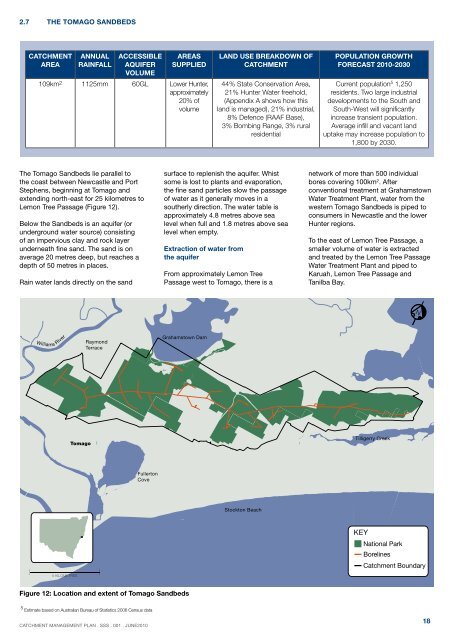
2.7 The Tomago SandbedsCatchmentareaAnnualrainfallACCESSIBLEAQUIFERVOLUMEAreassupplied109km 2 1125mm 60GL Lower Hunter,approximately20% ofvolumeLand use breakdown ofcatchment44% State Conservation Area,21% Hunter Water freehold,(Appendix A shows how thisland is managed), 21% industrial,8% Defence (RAAF Base),3% Bombing Range, 3% ruralresidentialPopulation growthforecast 2010-2030Current population 5 1,250residents. Two large industrialdevelopments to the South andSouth-West will significantlyincrease transient population.Average infill and vacant landuptake may increase population to1,800 by 2030.The Tomago Sandbeds lie parallel tothe coast between Newcastle and PortStephens, beginning at Tomago andextending north-east for 25 kilometres toLemon Tree Passage (Figure 12).Below the Sandbeds is an aquifer (orunderground water source) consistingof an impervious clay and rock layerunderneath fine sand. The sand is onaverage 20 metres deep, but reaches adepth of 50 metres in places.Rain water lands directly on the sandsurface to replenish the aquifer. Whistsome is lost to plants and evaporation,the fine sand particles slow the passageof water as it generally moves in asoutherly direction. The water table isapproximately 4.8 metres above sealevel when full and 1.8 metres above sealevel when empty.Extraction of water fromthe aquiferFrom approximately Lemon TreePassage west to Tomago, there is anetwork of more than 500 individualbores covering 100km 2 . Afterconventional treatment at GrahamstownWater Treatment Plant, water from thewestern Tomago Sandbeds is piped toconsumers in Newcastle and the lowerHunter regions.To the east of Lemon Tree Passage, asmaller volume of water is extractedand treated by the Lemon Tree PassageWater Treatment Plant and piped toKaruah, Lemon Tree Passage andTanilba Bay.NWilliams RiverRaymondTerraceGrahamstown DamTomagoTilligerry CreekFullertonCoveStockton BeachKEYNational ParkBorelinesCatchment Boundary5 KILOMETRESFigure 12: Location and extent of Tomago Sandbeds5 Estimate based on Australian Bureau of Statistics 2006 Census dataCATCHMENT MANAGEMENT PLAN . ssS . 001 . JUNE201018
The importance of the sandbeds to thesupply systemThe sandbeds are strategically importantfor both ongoing and backup watersupply. The ongoing supply from thesandbeds reduces the load on surfacewater sources and thereby allows greateroverall yield from the total water supplysystem. The large storage volume can beused as a reserve supply during droughtand is available as a backup supply inthe event of water quality issues in thesurface storages.Water quality and catchment healthWater from the Tomago aquifer is ofreliable quality. This has been the resultof both favourable natural conditionsand forward-looking land zoning. Sanditself is a good filter of contaminants andtherefore pollutants do not travel quicklyand are normally inactivated. In addition,most of land in the catchment areas hashistorically been zoned a water reservewhich preserves drinking water quality.To date, the most significant issue towater quality has been managing thearea’s grey sands which contain ironand arsenic minerals. These can oxidiseon exposure to air (eg during miningactivities) liberating dissolved forms ofthese metals to the groundwater. Someareas of the sandbeds are naturally veryhigh in dissolved minerals and otherareas may have been contaminatedby past mining activities. High minerallevels at some sites have caused theinactivation of some bores.Although industry at Tomago is not new,there has been increasing pressure fromindustrial land uses in and around thesandbeds due to a demand for industrialland close to Newcastle:• Tomago Aluminium, which producesairborne fluoride as a by-product ofthe refinery process, has expanded.• Other potentially polluting industries(eg a lead battery smelting facility)have been approved adjacent to thesandbeds.• Large manufacturing plants arebeing built on the outskirts of thecatchment with significant areas ofhard surface.• The Defence RAAF base hasexpanded over the aquiferwhich brings with it risks of fuelcontamination.It is becoming increasingly important towork with land use planners and industryin this area to protect the sandbeds as anatural resource.Grahamstown Dam, Tomago Sandbeds in the distanceCATCHMENT MANAGEMENT PLAN . ssS . 001 . JUNE201019
- Page 2 and 3: Table of contentsMessage from the M
- Page 4 and 5: Executive SummaryWater supply busin
- Page 6 and 7: Part 1: Introduction1.1 DOCUMENT Pu
- Page 8 and 9: “Preventive measures by their1.6
- Page 10 and 11: Part 2: Our drinking water catchmen
- Page 12 and 13: 2.3 A snapshot of Hunter Water’sc
- Page 14 and 15: NBarrington TopsNational ParkChiche
- Page 16 and 17: 2.6 Grahamstown DamCatchmentarea115
- Page 20 and 21: 2.8 The Tomaree (Nelson Bay) Sandbe
- Page 22 and 23: 2.10 The Paterson andAllyn RiversCa
- Page 24 and 25: 3.1 Element 1: Identify thetop haza
- Page 27 and 28: 637 6000williams river2Sinclairs Hi
- Page 29 and 30: Using this model it is possible to
- Page 31 and 32: 3.2.4 Hunter Water’s visionfor le
- Page 33 and 34: Freudenberg (1999) 9 recommendsthe
- Page 35 and 36: 3.4.3 Recent improvementsto the mon
- Page 37 and 38: 3.5.2 Hunter Water’s vision forca
- Page 39 and 40: 3.7 Element 7: EngagE thecommunityO
- Page 41 and 42: Appendix A:Items to observe during
- Page 43 and 44: Appendix C:The Land newspaper adver
- Page 45 and 46: Appendix E:Graphic used to illustra
2.7 The Tomago Sandbeds<strong>Catchment</strong>areaAnnualrainfallACCESSIBLEAQUIFERVOLUMEAreassupplied109km 2 1125mm 60GL Lower <strong>Hunter</strong>,approximately20% ofvolumeLand use breakdown ofcatchment44% State Conservation Area,21% <strong>Hunter</strong> <strong>Water</strong> freehold,(Appendix A shows how thisland is managed), 21% industrial,8% Defence (RAAF Base),3% Bombing Range, 3% ruralresidentialPopulation growthforecast 2010-2030Current population 5 1,250residents. Two large industrialdevelopments to the South andSouth-West will significantlyincrease transient population.Average infill and vacant landuptake may increase population to1,800 by 2030.The Tomago Sandbeds lie parallel tothe coast between Newcastle and PortStephens, beginning at Tomago andextending north-east for 25 kilometres toLemon Tree Passage (Figure 12).Below the Sandbeds is an aquifer (orunderground water source) consistingof an impervious clay and rock layerunderneath fine sand. The sand is onaverage 20 metres deep, but reaches adepth of 50 metres in places.Rain water lands directly on the sandsurface to replenish the aquifer. Whistsome is lost to plants and evaporation,the fine sand particles slow the passageof water as it generally moves in asoutherly direction. The water table isapproximately 4.8 metres above sealevel when full and 1.8 metres above sealevel when empty.Extraction of water fromthe aquiferFrom approximately Lemon TreePassage west to Tomago, there is anetwork of more than 500 individualbores covering 100km 2 . Afterconventional treatment at Grahamstown<strong>Water</strong> Treatment <strong>Plan</strong>t, water from thewestern Tomago Sandbeds is piped toconsumers in Newcastle and the lower<strong>Hunter</strong> regions.To the east of Lemon Tree Passage, asmaller volume of water is extractedand treated by the Lemon Tree Passage<strong>Water</strong> Treatment <strong>Plan</strong>t and piped toKaruah, Lemon Tree Passage andTanilba Bay.NWilliams RiverRaymondTerraceGrahamstown DamTomagoTilligerry CreekFullertonCoveStockton BeachKEYNational ParkBorelines<strong>Catchment</strong> Boundary5 KILOMETRESFigure 12: Location and extent of Tomago Sandbeds5 Estimate based on Australian Bureau of Statistics 2006 Census dataCATCHMENT MANAGEMENT PLAN . ssS . 001 . JUNE201018


