Technical Specifications
Technical Specifications
Technical Specifications
You also want an ePaper? Increase the reach of your titles
YUMPU automatically turns print PDFs into web optimized ePapers that Google loves.
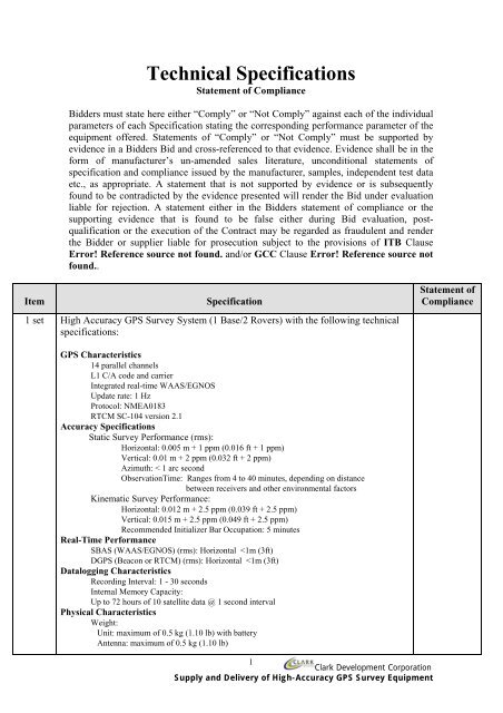
<strong>Technical</strong> <strong>Specifications</strong>Statement of ComplianceBidders must state here either “Comply” or “Not Comply” against each of the individualparameters of each Specification stating the corresponding performance parameter of theequipment offered. Statements of “Comply” or “Not Comply” must be supported byevidence in a Bidders Bid and cross-referenced to that evidence. Evidence shall be in theform of manufacturer’s un-amended sales literature, unconditional statements ofspecification and compliance issued by the manufacturer, samples, independent test dataetc., as appropriate. A statement that is not supported by evidence or is subsequentlyfound to be contradicted by the evidence presented will render the Bid under evaluationliable for rejection. A statement either in the Bidders statement of compliance or thesupporting evidence that is found to be false either during Bid evaluation, postqualificationor the execution of the Contract may be regarded as fraudulent and renderthe Bidder or supplier liable for prosecution subject to the provisions of ITB ClauseError! Reference source not found. and/or GCC Clause Error! Reference source notfound..ItemSpecification1 set High Accuracy GPS Survey System (1 Base/2 Rovers) with the following technicalspecifications:Statement ofComplianceGPS Characteristics14 parallel channelsL1 C/A code and carrierIntegrated real-time WAAS/EGNOSUpdate rate: 1 HzProtocol: NMEA0183RTCM SC-104 version 2.1Accuracy <strong>Specifications</strong>Static Survey Performance (rms):Horizontal: 0.005 m + 1 ppm (0.016 ft + 1 ppm)Vertical: 0.01 m + 2 ppm (0.032 ft + 2 ppm)Azimuth: < 1 arc secondObservationTime: Ranges from 4 to 40 minutes, depending on distancebetween receivers and other environmental factorsKinematic Survey Performance:Horizontal: 0.012 m + 2.5 ppm (0.039 ft + 2.5 ppm)Vertical: 0.015 m + 2.5 ppm (0.049 ft + 2.5 ppm)Recommended Initializer Bar Occupation: 5 minutesReal-Time PerformanceSBAS (WAAS/EGNOS) (rms): Horizontal
User Interface:Full color advanced TFT liquid crystal display with backlight320 x 240 resolution with 262.144 colorsResistive touch panelKeyboard with backlight 20 buttonsAudio: built-in speakerMemory:128 MB SDRAM, 128 NAND Flash memoryInterface:RS232USB: host and slaveBluetooth wireless technology- Specification 1.2 compliant- Point-to-point and point-to-multi-point- Profiles: serial port, OBEX, dial up networkingEnvironmental CharacteristicsReceiver:Operating Temperature: -10°C to 60°C (14°F to 140°F)Storage Temperature: -20°C to 70°C (-4°F to 158°F)Weather: Water-resistantShock: 1.5 m (4.9 ft) drop on concreteAntenna:Operating Temperature: -55°C to 85°C (-67°F to 185°F)Weather: WaterproofShock: 2 m (6.6 ft) drop on concretePower CharacteristicsBattery type: 3.7 V Li-Ion, 3900 mAhBattery life: 8 hours (typical operation)External power for extended operation timeField Software ToolsGPS UtilitiesBluetooth ManagerSystem / Data Back-up / RestoreEmissions CertificationImmunity (EN 55022 Class B)Susceptibility (EN 50082-1)FCC and CE certifiedSYSTEM ACCESSORIES:3x External Antenna3x Vertical Antenna Extension3x Field Bracket3x Carrying Case3x Lithium Battery Pack6x Stylus3x USB Data Cable3x Tribrach1x Card Reader1x Post-processing (L1) Software with computer hardware1x Kinematic Initializer Bar w/Quick Release Set1x CD Assembly, User Documentation & Office Software with computer hardware3x External Antenna Cable3x High-measurement Tape3x Field System Bag3x Hand Strap3x 32MB SD Memory Card3x Clip-On I/O Module3x Universal AC Adapter3x Aluminum Tripod2Clark Development CorporationSupply and Delivery of High-Accuracy GPS Survey Equipment
1x Range Pole1x Leveling Bubble1x Car Navigation AntennaSurvey: Post-Processing Software Installed in a Notebook Computer HardwareKey post-processing software functions include the following: Integrated transformation and grid system computations allow for processing, adjusting, reporting, andexporting point positions in user-selected or user-defined systems (including RINEX formatconversion). Pre-defined datums along with user-defined capabilities using the 7-parameter method of computingand applying datum transformation parameters. Survey mission planning. Automatic vector processing. Least-squares network adjustment. Data analysis and quality control tools. Coordinate transformations. Geoid 03.Notebook computer hardware should meet the following: CPU Technology Intel® Pentium Dual core T4200 2.0 GHz or higher Operating System Genuine Windows XP System Memory 1 GB DDR2 or higher Graphics Mobile Intel® GMA 4500M Display 14.1” WXGA display High Def. BrightView Display Hard Disk Drive 250 GB 5400 rpm SATA Optical Disc Drive DVD Super Multi Drive Wireless LAN 802.11a/b/g Bluetooth Integrated Bluetooth Webcam Integrated Camera Battery 6-Cell Battery USB Ports 3 USB 2.0 Speakers Altec Lansing Card Reader 5-in-1 Card Reader Microphone YesGIS: Office Software Installed in a Desktop Computer HardwareKey GIS office software functions include the following: Feature Library Editor. Background Map Creation. Job Creation and Editing. Differential Correction. GIS Data Display and Editing. GIS Import/Export: ESRI, SHP, MapInfo .MIF, and AutoDesk .DXF import/export and .CSV export. Geoid 03.Desktop computer hardware should meet the following: Processor Intel® Pentium Dual Core E5200 2.5 GHz 2MB 800 FSB or higher Operating System Genuine Windows XP Chipset NVIDIA® GeForce® 7100 and nForce® 630i Memory 2 GB of DDR2 800 MHz SDRAM Hard Drive 320GB SATA II 7200RPM Optical Drive 16x SuperMulti with Labelflash TM technology Graphics Integrated NVDIA® GeForce® 7100 graphics solutionP205Hxbd 20” Widescreen LCD Monitor with DVIPCI Express® 2.0 x 16 graphics card support (low-profile) Audio Embedded high-defenition audio with 5.1-channel surroundsound supports/PDIF (Sony/Philips Digital Interface) support3Clark Development CorporationSupply and Delivery of High-Accuracy GPS Survey Equipment
Networking Gigabit Ethernet I/O ports Front:Five USB 2.0 portsMulti-in-one card readerHigh-definition headphone and microphone jacksIEEE 1394 port (4-pin)Rear:Four USB 2.0 portsPS/2 keyboard and mouse portsFive audio portsEthernet (RJ-45) portD-sub VGA portHDMI TM porteSATA portOptical S/PDIF portCOM port I/O expansion PCI Express® 2.0 x 16 (one slot available)PCI Express® 2.0 x 1 (one slot available) Dimensions 265 (H) x 352 (D) x 100 (W) mm (with bezel) Power Supply 220 WPLUS: GPS Training for CDC-BURD Property Survey Team for at least three (3) days.Note: All items should be covered with a one (1) year maintenance/replacement warranty4Clark Development CorporationSupply and Delivery of High-Accuracy GPS Survey Equipment


