

searchable PDF - Association for Mexican Cave Studies
searchable PDF - Association for Mexican Cave Studies
searchable PDF - Association for Mexican Cave Studies
- No tags were found...

Create successful ePaper yourself
Turn your PDF publications into a flip-book with our unique Google optimized e-Paper software.
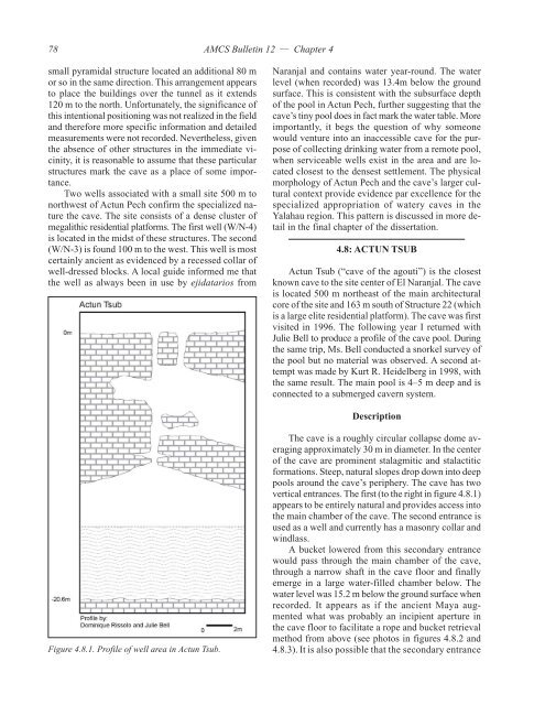
78AMCS Bulletin 12 — Chapter 4small pyramidal structure located an additional 80 mor so in the same direction. This arrangement appearsto place the buildings over the tunnel as it extends120 m to the north. Un<strong>for</strong>tunately, the significance ofthis intentional positioning was not realized in the fieldand there<strong>for</strong>e more specific in<strong>for</strong>mation and detailedmeasurements were not recorded. Nevertheless, giventhe absence of other structures in the immediate vicinity,it is reasonable to assume that these particularstructures mark the cave as a place of some importance.Two wells associated with a small site 500 m tonorthwest of Actun Pech confirm the specialized naturethe cave. The site consists of a dense cluster ofmegalithic residential plat<strong>for</strong>ms. The first well (W/N-4)is located in the midst of these structures. The second(W/N-3) is found 100 m to the west. This well is mostcertainly ancient as evidenced by a recessed collar ofwell-dressed blocks. A local guide in<strong>for</strong>med me thatthe well as always been in use by ejidatarios fromNaranjal and contains water year-round. The waterlevel (when recorded) was 13.4m below the groundsurface. This is consistent with the subsurface depthof the pool in Actun Pech, further suggesting that thecave’s tiny pool does in fact mark the water table. Moreimportantly, it begs the question of why someonewould venture into an inaccessible cave <strong>for</strong> the purposeof collecting drinking water from a remote pool,when serviceable wells exist in the area and are locatedclosest to the densest settlement. The physicalmorphology of Actun Pech and the cave’s larger culturalcontext provide evidence par excellence <strong>for</strong> thespecialized appropriation of watery caves in theYalahau region. This pattern is discussed in more detailin the final chapter of the dissertation.4.8: ACTUN TSUBActun Tsub (“cave of the agouti”) is the closestknown cave to the site center of El Naranjal. The caveis located 500 m northeast of the main architecturalcore of the site and 163 m south of Structure 22 (whichis a large elite residential plat<strong>for</strong>m). The cave was firstvisited in 1996. The following year I returned withJulie Bell to produce a profile of the cave pool. Duringthe same trip, Ms. Bell conducted a snorkel survey ofthe pool but no material was observed. A second attemptwas made by Kurt R. Heidelberg in 1998, withthe same result. The main pool is 4–5 m deep and isconnected to a submerged cavern system.DescriptionFigure 4.8.1. Profile of well area in Actun Tsub.The cave is a roughly circular collapse dome averagingapproximately 30 m in diameter. In the centerof the cave are prominent stalagmitic and stalactitic<strong>for</strong>mations. Steep, natural slopes drop down into deeppools around the cave’s periphery. The cave has twovertical entrances. The first (to the right in figure 4.8.1)appears to be entirely natural and provides access intothe main chamber of the cave. The second entrance isused as a well and currently has a masonry collar andwindlass.A bucket lowered from this secondary entrancewould pass through the main chamber of the cave,through a narrow shaft in the cave floor and finallyemerge in a large water-filled chamber below. Thewater level was 15.2 m below the ground surface whenrecorded. It appears as if the ancient Maya augmentedwhat was probably an incipient aperture inthe cave floor to facilitate a rope and bucket retrievalmethod from above (see photos in figures 4.8.2 and4.8.3). It is also possible that the secondary entrance


