
Create successful ePaper yourself
Turn your PDF publications into a flip-book with our unique Google optimized e-Paper software.
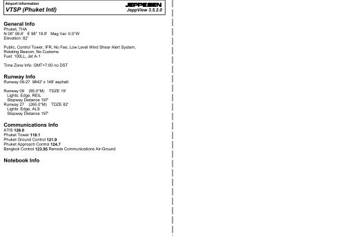
Airport Information<strong>VTSP</strong> (<strong>Phuket</strong> <strong>Intl</strong>)JEPPESENJeppView 3.5.2.0General Info<strong>Phuket</strong>, THAN 08° 06.6' E 98° 18.8' Mag Var: 0.0°WElevation: 82'Public, Control Tower, IFR, No Fee, Low Level Wind Shear Alert System,Rotating Beacon, No CustomsFuel: 100LL, Jet A-1Time Zone Info: GMT+7:00 no DSTRunway InfoRunway 09-27 9842' x 148' asphaltRunway 09 (85.0°M) TDZE 19'Lights: Edge, REILStopway Distance 197'Runway 27 (265.0°M) TDZE 82'Lights: Edge, ALSStopway Distance 197'Communications InfoATIS 128.0<strong>Phuket</strong> Tower 118.1<strong>Phuket</strong> Ground Control 121.9<strong>Phuket</strong> Approach Control 124.7Bangkok Control 123.95 Remote Communications Air-GroundNotebook Info
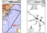
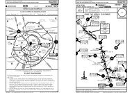
Licensed to max. Printed on 22 Jun 2008.Notice: After 4 Jul 2008 0901Z, this chart may no longer be valid. Disc 12-2008<strong>VTSP</strong>/HKTPHUKET INTL15 JUN 07JEPPESEN10-3039^DSTNSURAT THANI110.6 STNJEPPESENJeppView 3.5.2.0Apt Elev Trans level: FL130 Trans alt: 11000'82' Contact <strong>Phuket</strong> RADAR on 124.7 after take-off.3300'070^hdgPHUKETDPUT116.9 PUTN08 06.9 E098 18.4(RWY 09)(RWY 27)N09 07.8 E099 08.1D78 PUTRwy 09 requires a minimum climb gradientof: 4.3%Gnd speed-KT 75 100 150 200 250 3004.3% V/V (fpm) 327 435 653 871 1089 1306Not above11000'(STN 1B)SURAT ONE BRAVO010^hdg(RWY 09)(RWY 27)(STN 1A).G.458.SURAT ONE ALFA090^180^3000'.SID.4600'270^MSA PUT VORNOT TO SCALEAt or abovePHUKET 2500'At or aboveDPUT116.9 PUT2500'N08 06.9 E098 18.4SIDINITIAL CLIMBSURAT ONE ALFAClimb runway heading until 2500' or above. Then turn LEFT heading 010^to intercept and proceed on PUT R-039. EXPECT RADAR control.SURAT ONE BRAVOClimb runway heading until 2500' or above. Then turn RIGHT heading 070^to intercept and proceed on PUT R-039. EXPECT RADAR control.At or above2500'SURAT ONE ALFA (STN 1A) DEPARTURESURAT ONE BRAVO (STN 1B) DEPARTUREAt or above2500'Not above11000'TRANG ONE ALFA (TRN 1A) DEPARTURETRANG ONE BRAVO (TRN 1B) DEPARTUREPHUKET, THAILANDNOT TO SCALELicensed to max. Printed on 22 Jun 2008.Notice: After 4 Jul 2008 0901Z, this chart may no longer be valid. Disc 12-2008<strong>VTSP</strong>/HKTPHUKET INTL15 JUN 07134^JEPPESENJeppView 3.5.2.0Apt Elev Trans level: FL130 Trans alt: 11000'82' Contact <strong>Phuket</strong> RADAR on 124.7 after take-off.3300'At or above2500'PHUKETDPUT116.9 PUTN08 06.9 E098 18.4100^hdgUTHAI ONE BRAVO(UTHAI 1B)(RWY 09)JEPPESEN10-3AUTHAI ONE ALFA (UTHAI 1A) DEPARTUREUTHAI ONE BRAVO (UTHAI 1B) DEPARTURENOT TO SCALE(RWY 27)Not above11000'At or above2500'160^hdgUTHAI ONE ALFA(UTHAI 1A)Not above11000'.R.325.PHUKET, THAILAND090^D97UTHAIN07 00.1E099 29.8180^3000'.SID.4600'270^MSA PUT VORTRANG ONE ALFA100^CHANGES: MSA, new format.hdg130^ hdg115^TRANG ONE BRAVO(TRN 1B)Rwy 09 requires a minimum climb gradientof: 4.3%Gnd speed-KT 75 100 150 200 250 3004.3% V/V (fpm) 327 435 653 871 1089 1306(TRN 1A).W.14.TRANGD116.6 TRN TRNN07 30.5 E099 37.6D86 PUTSIDINITIAL CLIMBTRANG ONE ALFAClimb runway heading until 2500' or above. Then turn RIGHT heading 130^to intercept and proceed on PUT R-115. EXPECT RADAR control.TRANG ONE BRAVOClimb runway heading until 2500' or above. Then turn LEFT heading 100^to intercept and proceed on PUT R-115. EXPECT RADAR control.Not above11000'| JEPPESEN SANDERSON, INC., 2007. ALL RIGHTS RESERVED.Rwy 09 requires a minimum climb gradientof: 4.3%Gnd speed-KT 75 100 150 200 250 3004.3% V/V (fpm) 327 435 653 871 1089 1306SIDUTHAI ONE ALFAUTHAI ONE BRAVOINITIAL CLIMBClimb runway heading until 2500' or above. Then turn RIGHT heading 160^to intercept and proceed on PUT R-134. EXPECT RADAR control.Climb runway heading until 2500' or above. Then turn LEFT heading 100^to intercept and proceed on PUT R-134. EXPECT RADAR control.CHANGES: MSA, new format.| JEPPESEN SANDERSON, INC., 2007. ALL RIGHTS RESERVED.
CHANGES: NDB removed.| JEPPESEN SANDERSON, INC., 1999, 2007. ALL RIGHTS RESERVED.CHANGES: None.| JEPPESEN SANDERSON, INC., 1999, 2007. ALL RIGHTS RESERVED.Licensed to max. Printed on 22 Jun 2008.Notice: After 4 Jul 2008 0901Z, this chart may no longer be valid. Disc 12-2008<strong>VTSP</strong>/HKTApt ElevN08 06.6 E098 18.898-1882'2 NOV 07JEPPESEN10-9JEPPESENJeppView 3.5.2.0PHUKET, THAILANDPHUKET INTLATIS PHUKET Ground Tower128.0 121.9 118.198-1998-20Licensed to max. Printed on 22 Jun 2008.Notice: After 4 Jul 2008 0901Z, this chart may no longer be valid. Disc 12-2008<strong>VTSP</strong>/HKT2 NOV 07RWY 09-27JEPPESEN10-9AE098-18.2 E098-18.3 E098-18.4CJEPPESENJeppView 3.5.2.0PHUKET, THAILANDPHUKET INTLDN08-06.7N08-06.7Low-level wind shear alert system.Maneuvering on movement area:1. Most all of the area between apron Alpha to Charlie is the blind spot area, when ATCinstruction is issued, aircraft are to maneuver by pilot discretion.2. Simultaneous operations on near parallel taxiway due to minimum separation distance betweenrunway centerline and taxiway centerline is 492' (150m). When IMC, the wide body aircraft maybe requested to hold on the taxiway for wide body aircraft landing or take-off.3. Taxiing on taxiway Papa in connection with taxiway Echo due to the minimum separation distancebetween taxiway centerline and objects is 130' (39.6m) wide body aircraft to taxi with extremecaution.01^WN08-06.6APBP21 22 23 24 25 26 27 28APRON C6 5 4 3 2 1APRON BPPN08-06.6148'08-07 197'60m 08-07VORStopway197'Stopway09085^60mElev 19'ABCDEARPFOR PARKINGPOSITIONS SEECHART 10-9A9842' 3000mPTaxiways C and D limited to light aircraft.FGControl TowerElev 82'27265^N08-06.57APRON A8910PASSENGERTERMINALN08-06.598-18BldgAreaFeetMeters00100098-195002000 3000 400010005000150098-20N08-06.41211N08-06.409RWY27HIRLHIRLREILSALSADDITIONAL RUNWAY INFORMATIONUSABLE LENGTHSLANDING BEYONDThreshold Glide Slope TAKE-OFFPAPI (angle 3.0^)RVRPAPI (angle 3.2^)RVR9076' 2766mWIDTH148'45mN08-06.3E098-18.2151413E098-18.3E098-18.5N08-06.3E098-18.6PARKING BAY COORDINATESBAY No. COORDINATES BAY No. COORDINATESAPRON BAPRON C1, 23 thru 56N08 06.6 E098 18.5N08 06.6 E098 18.4N08 06.6 E098 18.321 thru 2324 thru 28N08 06.7 E098 18.4N08 06.7 E098 18.5ABCDAIR CARRIERLVP must be in ForceAll RwysRCLM (DAY only)or RL250m300mAll RwysRCLM (DAY only)or RL400mTAKE-OFF2Eng3 & 4EngAIR CARRIER (FAR 121)All RwysAdequate Vis RefRVR 500mVIS 400mAPRON A7 thru 9 N08 06.5 E098 18.310 thru 12 N08 06.4 E098 18.313 thru 15 N08 06.3 E098 18.3
Licensed to max. Printed on 22 Jun 2008.Notice: After 4 Jul 2008 0901Z, this chart may no longer be valid. Disc 12-2008<strong>VTSP</strong>/HKTJEPPESENJEPPESENJeppView 3.5.2.0PHUKET, THAILAND18 APR 08 10-9B PHUKET INTLRLG DOCKING SYSTEM-IN SYSTEM AT PHUKET INTL AIRPORT1. INTRODUCTION1.1 The RLG docking system-in system is installed at bays 4, 8, 9 and 10.1.2 The system enables the pilots seated on the left of the cockpit to positionhis aircraft on the correct stand centerline and stop position.2. PILOT OPERATING INSTRUCTIONS2.1 The pilot or co-pilot simply follows the center azimuth steering bars tokeep the aircraft at the center, and to keep the aircraft to a reasonablespeed.2.2 The azimuth indication consists of a central green bar and two red barsoneto each side of the green bar. The center green bar will always be on,while the red side bars will only come on, one at a time, when the aircraftis off center.2.3 If the aircraft veers too far to the right, the right red bar will come on,along with the center green bar. Conversely, if the aircraft veers too farto the left, the left red bar will come on, along with the center green bar.The pilot would simply steer towards the green bar to get back to thecenter J-line.2.4 When the aircraft is more than 30 meters away from the docking position,the only indications will be the aircraft type displayed on the first displayline, and the azimuth bar(s) at lower center of the Pilot Display unit.2.5 Starting at 30 meters, the close-in distance will be displayed on thesecond display line, along with the progress meter at the lower left cornerof the Pilot Display unit. The close in distance will be updated in 1meter increments.2.6 Starting at 10 meters, the close-in distance will be displayed in 0.2 meterincrements.2.7 If the aircraft is moving too fast, the Aircraft Display unit will let thepilot know by displaying the message "2 FAST". The pilot should slowdown the aircraft until the "2 FAST" message disappears.2.8 If the incoming aircraft does not match the expected aircraft (shown onthe top line of display) the message "NO ID" will immediately be displayedon the first line, and the message "STOP", in red, on the second line ofdisplay. The pilot must stop the aircraft immediately, and follow anyinstructions from the ground crew.2.9 If the aircraft overshoots and moves beyond the designated dockingposition, the Aircraft Display will display the message "2 FAR" toindicate the over travel. The pilot should also stop the plane immediatelyif this happens.2.10 RLG system parking sequencea.) In this picture the aircraft is at a distance greater than30 meters from the parking position and is directly at thecenterline.Note that the progress bar and digital close-in distanceare not displayed when the aircraft is greater than 30meters away from the docking position. A Boeing 747aircraft is expected.B747Licensed to max. Printed on 22 Jun 2008.Notice: After 4 Jul 2008 0901Z, this chart may no longer be valid. Disc 12-2008JEPPESENJeppView 3.5.2.0JEPPESEN<strong>VTSP</strong>/HKT PHUKET, THAILAND18 APR 08 10-9C PHUKET INTLe.) The aircraft is now at 6.2 meters from the docking positionand has again veered off the left of centerline.Note that at below 10 meters, the close-in distance isdisplayed in 0.2 meter increments.f.) Finally the aircraft is perfectly parked at the stop position,and perfectly centered.The word "STOP" is displayed in red. Note also the mergingof the arrow and the stop line on the progress meter.B7476.2MB747STOP3. ALLOCATION OF AIRCRAFT PARKING BAYSAll aircraft parking bays are allocated by Ground/Apron controller withregard to aircraft type involved and prevailing or anticipated traffic situation.4. AIRCRAFT MARSHALLING AND TOWING SERVICESThe marshalling of scheduled, non-scheduled and casual aircraft into the bayseither manually or by the aid of the RLG Guide-in system and the pushing outof aircraft for departure shall be under the responsibility of the aircraftoperator or its appointed ground handling agency.5. TAXIING PROCEDURES5.1 Arriving AircraftAircraft entering the aprons are to follow closely to the taxiway and aproncenterline so as to avoid reducing safety distances between them andparking aircraft.5.2 Departing AircraftWhen start-up clearance is issued by ATC, then pushed out onto aproncenterline.b.) In this picture the aircraft is exactly 30 meters from thedocking position, but is off to the right of the centerline.Starting at 30 meters, the digital close-in distance(second line of display) is displayed, in 1 meter increments.The progress meter (lower left) will also be activated atthis distance.c.) The aircraft is at 20 meters from the docking position andhas returned to the centerline.Note position of progress meter. The arrow will advanceon position every 2.5 meters.B74730MB74720Md.) In this picture the aircraft is at 10 meters and is on thecenterline.B74710MCHANGES: New procedure.| JEPPESEN, 2008. ALL RIGHTS RESERVED.CHANGES: New procedure.| JEPPESEN, 2008. ALL RIGHTS RESERVED.
Licensed to max. Printed on 22 Jun 2008.Notice: After 4 Jul 2008 0901Z, this chart may no longer be valid. Disc 12-2008JEPPESENJeppView 3.5.2.0JEPPESEN<strong>VTSP</strong>/HKT PHUKET, THAILAND18 APR 08 10-9D PHUKET INTLLicensed to max. Printed on 22 Jun 2008.Notice: After 4 Jul 2008 0901Z, this chart may no longer be valid. Disc 12-2008JEPPESENJeppView 3.5.2.0JEPPESEN<strong>VTSP</strong>/HKT PHUKET, THAILAND18 APR 08 10-9E PHUKET INTLINTRODUCTIONSAFEDOCK TYPE 25 LASER SCANNER SYSTEMThe safedock type 25 laser scanner system is installed at parking bays NR1 and11. The docking system enables wide-body aircraft to park at the correct positionon the parking bays without the assistance of a marshaller. Pilots should notexceed a speed of 6 kts when using the docking system.The system consists of a display screen and laser scanner located at the terminalwall in front of the parking bays to ensure the aircraft stops in the correctlocation relative to the airbridges.THE SYSTEM DESCRIPTIONThe system consists of two components which supply the following informationto the pilot:a. The top alphanumeric information display which shows aircraft type designationin yellow.b. The azimuth and centerline guidance display in red and yellow and the closingrate bar in yellow.TYPES OF AIRCRAFTThe types of aircraft are programmed into the system and the additional aircrafttypes can be selected from the operator panel before the aircraft approaches theparking stand.All types of aircraft programmed into the system are as follows:SAFEGATE DOCKING SYSTEM-IN SYSTEM AT PHUKET INTL AIRPORT1. INTRODUCTION1.1 The SAFEGATE Docking System-in system is installed at bays 5, 6 and 7.1.2 The system enables the pilots seated on the left of the cockpit to positionhis aircraft on the correct stand centerline and stop position.2. PILOT OPERATING INSTRUCTION2.1 Safety Procedurea.) General warningThe DGS system has a built-in error detection program to inform theaircraft pilot of impending dangers during the docking procedure.If the pilot is unsure of the information, being shown on the DGSdisplay unit, he must immediately stop the aircraft and obtain furtherinformation for clearance.b.) Item to check before entering the stand areaWarning: The pilot shall not enter the stand area, unless the dockingsystem first is showing the vertical running arrows. The pilot must notproceed beyond the bridge, unless these arrows have been supersededby the closing rate bar.Warning: The pilot shall not enter the stand area, unless the aircrafttype displayed is equal to the approaching aircraft/The Correctness ofother information, such as 'door 2', shall also be checked.c.) The SBU messageThe message STOP SBU means that docking has been interrupted andhas to be resumed only by manual guidance. Do not try to resumedocking without manual guidance.BayB707 B727 B737 B757 B767 DC8 DC9 A300 A310 A319 A320 A321 A330111Bay A340 DC10 MD11 B741 B742 B743 B744 B777 L10111112.2 START OF DOCKINGThe system is started by pressing one of the aircraft typebuttons on the operator panel. When the button has beenpressed, WAIT will be displayed.WAIT2.3 CAPTUREThe floating arrows indicate that the system is activatedand in capture mode, searching for an approaching aircraft.It shall be checked that the correct aircraft type is displayed.The lead-in line shall be followed.The pilot must not proceed beyond the bridge, unless thearrows have been superseded by closing rate bar.B747CHANGES: New chart.| JEPPESEN, 2008. ALL RIGHTS RESERVED.CHANGES: New procedure.| JEPPESEN, 2008. ALL RIGHTS RESERVED.
Licensed to max. Printed on 22 Jun 2008.Notice: After 4 Jul 2008 0901Z, this chart may no longer be valid. Disc 12-2008JEPPESENJeppView 3.5.2.0JEPPESEN<strong>VTSP</strong>/HKT PHUKET, THAILAND18 APR 08 10-9H PHUKET INTL2.19 TOO FASTIf the aircraft approaches with a speedhigher than the docking system can handle,the message STOP (with red squares) andTOO FAST will be displayed.The docking system must be re-started ordocking procedure completed by manualguidance.2.20 EMERGENCY STOPWhen the emergency stop button is pressed, STOP isdisplayed.STOPTOOSTOPFASTLicensed to max. Printed on 22 Jun 2008.Notice: After 4 Jul 2008 0901Z, this chart may no longer be valid. Disc 12-2008<strong>VTSP</strong>/HKTSTRAIGHT-IN RWY0927VOR ZVOR YILSFULLALS outLOCALS outVOR YALS outJEPPESENJeppView 3.5.2.0.JAA.MINIMUMS.21 SEP 07 10-9XPHUKET INTLA B C D850'(831') 850'(831') 850'(831') 850'(831')R1500m R1500m R2000m R2000mR1500m540'(458')R1000mR1200m770'(688')R1500m540'(458')540' (458') 550' (468')R1000m R1000mR1200mR1200mR2000m2000mPHUKET, THAILAND1260'(1241') 1260'(1241') 1260'(1241') 1260'(1241')R1500mR1500m1080'(998')R1500mR1500mJEPPESENR1000mR1200m770'(688') 770'(688') 770'(688')R1500mR1500mR2000mR2000mR2000m2000mVOR Z 1060' (978') 1060'(978') 1060'(978') 1060'(978')R1500m R1500m R2000m R2000mALS out R1500mR1500mR2000mR2000m1080'(998') 1080'(998') 1080'(998')R1500m R2000m R2000mR1500mR2000mR2000m2.21 CHOCKS ONCHOCK ON will be displayed, when the ground staff has putthe chocks in front of the nose wheel and pressed the"Chocks on" button on the operator panel.CHOCKON11CIRCLE-TO-LAND 100 Kt 135 Kt180 Kt 205 KtAfter all approaches 1300'(1218') 1300'(1218') 1400'(1318') 1400'(1318')V1500m V1600m V2400m V3600mNot Authorized South of Airport.TAKE-OFF2.22 ERRORIf a system error occurs, the message ERROR is displayedwith an error code. The code is used for maintenancepurposes and explained elsewhere.ERROR3ABCDAIR CARRIERLVP must be in ForceAll RwysRCLM (DAY only)or RL250m300mAll RwysRCLM (DAY only)or RL400m2Eng3 & 4EngAIR CARRIER (FAR 121)All RwysAdequate Vis RefRVR 500mVIS 400m2.23 SYSTEM BREAKDOWNIn case of a severe system failure, the display will go black,except for a red stop indicator. A manual backup proceduremust be used for docking guidance.2.24 POWER FAILUREIn case of a power failure, the display will be completelyblack. A manual backup procedure must be used for dockingguidance.CHANGES: New procedure.| JEPPESEN, 2008. ALL RIGHTS RESERVED.CHANGES: Minimums.| JEPPESEN SANDERSON, INC., 2002, 2007. ALL RIGHTS RESERVED.
360^180^BRIEFING STRIP TMLicensed to max. Printed on 22 Jun 2008.Notice: After 4 Jul 2008 0901Z, this chart may no longer be valid. Disc 12-2008<strong>VTSP</strong>/HKTJEPPESENPHUKET INTL 24 AUG 07 11-1 .Eff.30.Aug.1099'960'540' D2.0 IPKTPHUKETDPUT 116.9 PUT1476'824'069^105^JEPPESENJeppView 3.5.2.0PHUKET, THAILANDILS or LOC Rwy 27ATIS PHUKET Approach (R) PHUKET Tower Ground128.0 124.7 118.1121.9LOCFinalGSILSIPKT Apch CrsD7.0 IPKT DA(H)Apt Elev 82'D6.9 PUT Refer to109.9 267^Rwy 27 82' 3300'2000'(1918') MinimumsMISSED APCH: Climb STRAIGHT AHEAD to 2500' then turn RIGHTdirect to D7.0 IPKT/D6.9 PUT at 2500' and hold or as directed 2900'by ATC.Alt Set: hPa Rwy Elev: 3 hPa Trans level: FL 130 Trans alt: 11000'1. PUT VOR DME and IPKT DME required.08-1008-00IPKT DMEALTITUDEOFFSET LOCTCH 55'IPKTILS DME267^ 109.9 IPKTLoc Crs offset 1.4^Rwy centerline 265^MM4.0 5.0 6.0 7.0985' 1325' 1665' 2000'CMMD7.0D6.9087^RWY 27 82' 0.5 5.0IPKTPUTD7.0 IPKT D12.0 IPKTD6.9 PUTD11.9 PUT267^267^98-20 98-30D2.0 IPKT1411'GS2000'1263'1017'087^2000'222^(IF)D12.0 IPKTD11.9 PUT2500'5.0312^2500267^8.01119'267^25008.0090^ANFILD18.5 PUTD18.6 IPKT46002500'180^ 360^4600'3000'MSA PUT VOR915'(IAF)1047'270^(IAF)MANYUD18.5 PUTD18.6 IPKT3000BRIEFING STRIP TMLicensed to max. Printed on 22 Jun 2008.Notice: After 4 Jul 2008 0901Z, this chart may no longer be valid. Disc 12-2008<strong>VTSP</strong>/HKTJEPPESENPHUKET INTL2 NOV 07 13-1JEPPESENJeppView 3.5.2.0PHUKET, THAILANDVOR Y Rwy 09ATIS PHUKET Approach (R) PHUKET Tower Ground128.0 124.7 118.1121.9VORFinalMDA(H) Apt Elev 82'PUTApch CrsNo FAF116.9 075^1260'(1241') Rwy 09 19' 3300'MISSED APCH: Climb STRAIGHT AHEAD to 2500' then turn LEFT,continue climbing to 3000' back to PUT VOR and hold or as2900'directed by ATC.Alt Set: hPa Rwy Elev: 1 hPa Trans level: FL 130 Trans alt: 11000'1. Arrival from Northwest and Northeast sector descend in holding pattern.08-1008-00CAT A & B075^25 NMDStart turn atCAT A & B:CAT C & D:2000'PHUKET116.9 PUT PUTCAT C & D267^3 Min2 Min274^CAT C & DCAT A & B094^98-10 98-20075^1099'960'540'274^267^3000274^VOR3000'1476'824'090^4600'270^3000'MSA PUT VOR1411'PANS OPS 3Gnd speed-Kts 70 90 100 120 140 160ILS GS 3.20^ orSALS401 516 574 688 803 918LOC Descent Gradient 5.6%PAPI PAPIMAP at MMFAF to MAP5.0 4:17 3:20 3:00 2:30 2:09 1:53STRAIGHT-IN LANDING RWY27ABCDDA(H)2500'CIRCLE-TO-LANDILSLOC (GS out)Not AuthorizedABC: 540'(458')MDA(H) 770'(688')South of AirportD:550'(468')MaxFULL ALS outALS out Kts MDA(H)2200mRVR1500mVIS 1600m1001351300'(1218') -2200m1300'(1218') -2400m2300mCHANGES: BUKIT renamed MANYU.3200m3600m180205RTDD7.0IPKTD6.9PUT1400'(1318') -4800m| JEPPESEN SANDERSON, INC., 2007. ALL RIGHTS RESERVED.PANS OPS 3MAP at VORABCDCHANGES: PU NDB removed.STRAIGHT-IN LANDING RWY09MDA(H) 1260'(1241')2000m2400m4800mMaxKts100135180205REILPAPIRWY 0919'2500'3000'CIRCLE-TO-LANDNot Authorized South of AirportMDA(H)1300'(1218') -2000m1300'(1218') -2400m1400'(1318') -4800mPUT116.9| JEPPESEN SANDERSON, INC., 2007. ALL RIGHTS RESERVED.LT
360^180^BRIEFING STRIP TMLicensed to max. Printed on 22 Jun 2008.Notice: After 4 Jul 2008 0901Z, this chart may no longer be valid. Disc 12-2008<strong>VTSP</strong>/HKTJEPPESEN2 NOV 07PHUKET INTL 13-2JEPPESENJeppView 3.5.2.0PHUKET, THAILANDVOR Z Rwy 09ATIS PHUKET Approach (R) PHUKET Tower Ground128.0 124.7 118.1121.9VORFinal Minimum AltMDA(H) Apt Elev 82'PUTApch Crs D6.0116.9 075^ 1900' (1881')850'(831')Rwy 09 19'MISSED APCH: Climb STRAIGHT AHEAD to 2500' then turn LEFT2900'direct to D6.0 at 2500' and hold or as directed by ATC.Alt Set: hPa Rwy Elev: 1 hPa Trans level: FL 130 Trans alt: 11000'1. PUT VOR DME required.180^3300' 4600'090^ 270^360^3000'MSA PUT VORBRIEFING STRIP TMLicensed to max. Printed on 22 Jun 2008.Notice: After 4 Jul 2008 0901Z, this chart may no longer be valid. Disc 12-2008<strong>VTSP</strong>/HKTJEPPESENPHUKET INTL 2 NOV 07 13-3JEPPESENJeppView 3.5.2.0PHUKET, THAILANDVOR Y Rwy 27ATIS PHUKET Approach (R) PHUKET Tower Ground128.0 124.7 118.1121.9VORFinalMDA(H) Apt Elev 82'PUTApch CrsNo FAF116.9 268^1080' (998') Rwy 27 82' 3300'MISSED APCH: Climb STRAIGHT AHEAD to 2500' then turn RIGHT,continue climbing to 3000' back to PUT VOR and hold or as2900'directed by ATC.Alt Set: hPa Rwy Elev: 3 hPa Trans level: FL 130 Trans alt: 11000'1. Arrival from Northwest and Northeast sector descend in holding pattern.090^4600'270^3000'MSA PUT VOR08-10 (IAF)RICHYD17.633008.02500273^120^(IF)D11.0[CS~9]075^DD6.0[FS~9]PHUKET116.9 PUT PUT255^D1.0[MA~9]1099'540'960'1476'824'08-10D3000069^249^PHUKET116.9 PUT PUT960'540'069^824'1411'CAT C & D076^ CAT A & B268^1263'1017'PANS OPS 3[CS~9]236^MALEED17.698-00 290098-10 98-20PUT DME 6.05.0ALTITUDE1900' 1600'[FS~9][2.99^]Gnd speed-Kts 70 90 100 120 140 160Descent Gradient 5.2% 369 474 527 632 738 843Descent angle [2.99^] 370 476 529 635 741 846MAP at D1.0 D6.0 to MAP 5.0 4:17 3:20 3:00 2:30 2:09 1:53STRAIGHT-IN LANDING RWY 09ABCD08-00(IAF)8.02500'030^2500D11.0CHANGES: PU NDB removed.075^075^2500'5.0MDA(H) 850'(831')RVR 1500m2000m4000m4400m255^1900'VIS 1600mD6.05.0VORD1.0[MA~9]REILPAPIMaxKts1001351802050.84.01280'2500'[TCH 50']RWY 09LT1650'19'DCIRCLE-TO-LAND3.0960'Not Authorized South of AirportMDA(H)1300'(1218')-2000m1300'(1218') -2400m1400'(1318') -4800mD6.0| JEPPESEN SANDERSON, INC., 2007. ALL RIGHTS RESERVED.PANS OPS 3MAP at VORABCD08-00RWY 27VOR3000'82'1099'98-10 98-20 98-30CHANGES: PU NDB removed.CAT C & DCAT A & BStart turn atCAT A & B:CAT C & D:PAPI PAPIRTSTRAIGHT-IN LANDING RWY27CIRCLE-TO-LANDMDA(H) 1080' (998')Not Authorized South of Airport2000m2400m4800m069^076^ALS out268^1476'MaxKts100135180205SALS2100'3 Min2 Min25 NM2500'3000'MDA(H)1300'(1218') -2000m1300'(1218') -2400m1400'(1318') -4800mPUT116.9| JEPPESEN SANDERSON, INC., 2007. ALL RIGHTS RESERVED.
Licensed to max. Printed on 22 Jun 2008.Notice: After 4 Jul 2008 0901Z, this chart may no longer be valid. Disc 12-2008<strong>VTSP</strong>/HKTJEPPESENPHUKET INTL2 NOV 07 13-4JEPPESENJeppView 3.5.2.0PHUKET, THAILANDVOR Z Rwy 27ATIS PHUKET Approach (R) PHUKET Tower GroundBRIEFING STRIP TM128.0 124.7 118.1121.9VORFinal Minimum AltMDA(H) Apt Elev 82'PUTApch Crs D7.0268^ 1900'(1818') 1060'(978') Rwy 27 82' 3300'116.9MISSED APCH: Climb STRAIGHT AHEAD to 2500' then turn RIGHTdirect to D7.0 at 2500' and hold or as directed by ATC.090^2900'4600'270^3000'180^ 360^Alt Set: hPa Rwy Elev: 3 hPa Trans level: FL 130 Trans alt: 11000'1. PUT VOR DME required.08-10DPHUKET116.9 PUT PUT540'960'D2.4824'1411'088^D7.0 268^1263'1017'(IF)221^D12.0069^8.12500MSA PUT VOR915'(IAF)ANFILD18.546001047'1099'311^08-00PUT DMEALTITUDE98-20 98-30VOR1476'1900'268^105^5.0 6.0 7.01280' 1600' 1900'D2.4D7.0 D12.0088^2500'268^7.925001119'2500'(IAF)MANYUD18.53000RWY 27 82' 1.0 4.6Gnd speed-Kts 70 90 100 120 140 160SALSDescent Gradient 5.2% 369 474 527 632 737 843PAPI PAPIMAP at D2.4D7.0 to MAP 4.6 3:57 3:04 2:46 2:18 1:58 1:43STRAIGHT-IN LANDING RWY27MDA(H)1060'(978')5.02500'RTDD7.0CIRCLE-TO-LANDNot Authorized South of AirportAB2000m2400mALS outMaxKts100135MDA(H)1300'(1218') -2000m1300'(1218') -2400mPANS OPS 3CD4800m1802051400'(1318') -4800mCHANGES: PU NDB removed.| JEPPESEN SANDERSON, INC., 2007. ALL RIGHTS RESERVED.