water sources, infrastructure, space and the dynamics of ...
water sources, infrastructure, space and the dynamics of ...
water sources, infrastructure, space and the dynamics of ...

You also want an ePaper? Increase the reach of your titles
YUMPU automatically turns print PDFs into web optimized ePapers that Google loves.
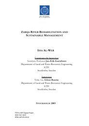
BilyimbaBaguliWater <strong>sources</strong>, <strong>infrastructure</strong>, Nadugu <strong>space</strong> No.1 <strong>and</strong> <strong>the</strong> <strong>dynamics</strong> <strong>of</strong> environmental diseases in Saboba District: Using GISFaliNakaku No. 1TekasuWabonAsareKukpeneGarikuka!.SambangAcheridoSettlementsRiversContoursRoadsW. Utindan-doBitin-doInagmabuniMagie Ug<strong>and</strong>oKinabusiaKpardorZegbeliBoaduNanwalbuJamboDemonYakaliJamoniJilmaJanbokToginSagbeGbonKokoliWalaKunjuulTombuNakpeuNaatagBukobChakpelangbini WagbalTingbalShegbini Wajori BiwaldoSanguliJabuniNafecheliLifur³Tisung JagridoKpeguKpasasene Nalogni No. 2YankaziaUnidoBodulSobibaWadejoKuwaniNakpalNayiliToma BorgbalnBuriburniNabuar Nalogni !. KiteekKujoniNakpani BukpamMpeasemGarimataKacheKujoni WayuubKungibJajelNakuru KabonbuSaladoNansonKuchaKudaniGbaniSambuli KuchachbuniWadigKudok KutuliPoon-BamDistance to Major Town (Metres)0 - 25002501 - 50005001 - 75007501 - 1000010001 - 43500WambongMulpedoKpalbaBichaanGnalajodo1:400,000Old NambiriFigure 8: Map <strong>of</strong> Saboba district showing distance <strong>of</strong> settlements to majortown33