Users Guide - the Virginia Modeling, Analysis and Simulation Center
Users Guide - the Virginia Modeling, Analysis and Simulation Center
Users Guide - the Virginia Modeling, Analysis and Simulation Center

Create successful ePaper yourself
Turn your PDF publications into a flip-book with our unique Google optimized e-Paper software.
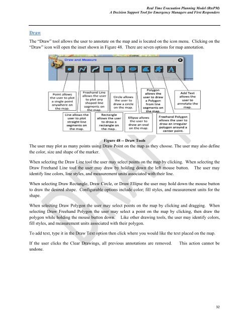
Real Time Evacuation Planning Model (RtePM)A Decision Support Tool for Emergency Managers <strong>and</strong> First RespondersDrawThe “Draw” tool allows <strong>the</strong> user to annotate on <strong>the</strong> map <strong>and</strong> is located on <strong>the</strong> icon menu. Clicking on <strong>the</strong>“Draw” icon will open <strong>the</strong> inset shown in Figure 48. There are seven options for map annotation.Figure 48 -- Draw ToolsThe user may plot as many points using Draw Point on <strong>the</strong> map as <strong>the</strong>y choose. The user may also define<strong>the</strong> color, size <strong>and</strong> shape of <strong>the</strong> marker.When selecting <strong>the</strong> Draw Line tool <strong>the</strong> user may select points on <strong>the</strong> map by clicking. When selecting <strong>the</strong>Draw Freeh<strong>and</strong> Line tool <strong>the</strong> user may draw by holding down <strong>the</strong> left mouse button. The user mayidentify line colors, line styles, <strong>and</strong> measurement units associated with <strong>the</strong>ir line.When selecting Draw Rectangle, Draw Circle, or Draw Ellipse <strong>the</strong> user may hold down <strong>the</strong> mouse buttonto draw <strong>the</strong> desired shape. Configurable options include color; fill styles, <strong>and</strong> measurement units for <strong>the</strong>shape.When selecting Draw Polygon <strong>the</strong> user may select points on <strong>the</strong> map by clicking <strong>and</strong> dragging. Whenselecting Draw Freeh<strong>and</strong> Polygon <strong>the</strong> user may select a point on <strong>the</strong> map by clicking, <strong>the</strong>n draw <strong>the</strong>polygon while holding <strong>the</strong> mouse button down. Like o<strong>the</strong>r drawing tools, <strong>the</strong> user may identify colors,fill styles, <strong>and</strong> measurement units associated with <strong>the</strong>ir polygon.To add text, type it in <strong>the</strong> Draw Text option <strong>the</strong>n click where you would like <strong>the</strong> text placed on <strong>the</strong> map.If <strong>the</strong> user clicks <strong>the</strong> Clear Drawings, all previous annotations are removed.undone.This action cannot be32